|
The combination of an upper-level trough with the center above the North Sea and a strong lee cyclogenesis over the Western Mediterranean brought abundant precipitation to the Alps, with 72 h precipitation totals reaching up to 400 mm. The heavy rains led to widespread river flooding in the Alps, causing a hundred-year flood along the Ötztaler Ache.
Severe Weather Outbreak Bavaria – August 26, 2023
As the trough above the North Sea neared Central Europe, very warm and moist air masses were advected into Southern Germany. The atmospheric sounding from 12 UTC at Munich showed already a substantial amount of CAPE in the middle atmosphere, while the boundary layer was capped by a strong capping inversion. The nearing trough induced mid-level lifting in the afternoon, overcoming the capping inversion. After 11 UTC embedded into a broad rain band originating from Switzerland, strong thunderstorms formed downwind of the Swabian Jura.
|
Atmospheric sounding (left) and hodograph (right) from Munich-Oberschleißheim, 26.08.2023 12 UTC, source:
University of Wyoming
|
 |
 |
In the following hours, the thunderstorms moved along the Alpine Foothills into Bavaria. Two distinct supercells formed, bringing torrential downpours with rain rates of more than 50 mm/h and very large hail, with hail stones reaching diameters of more than 5 cm. South of Augsburg, the town of Königsbrunn was hit by very large hail.
In the northern outskirts of the German Alps, the second supercells brought a violent hailstorm to towns just a few kilometers north of Garmisch-Partenkirchen. Hail stones reached diameters of more than 7 cm, with some reports suggesting that hailstones reached diameters of up to 10 cm. As a result, many cars and buildings were severly damaged. In the days following the event, many dead wildlife was found in the forest killed by the hail.
Heavy rain and flooding in the Alps – August 26, 2023, to August 29, 2023
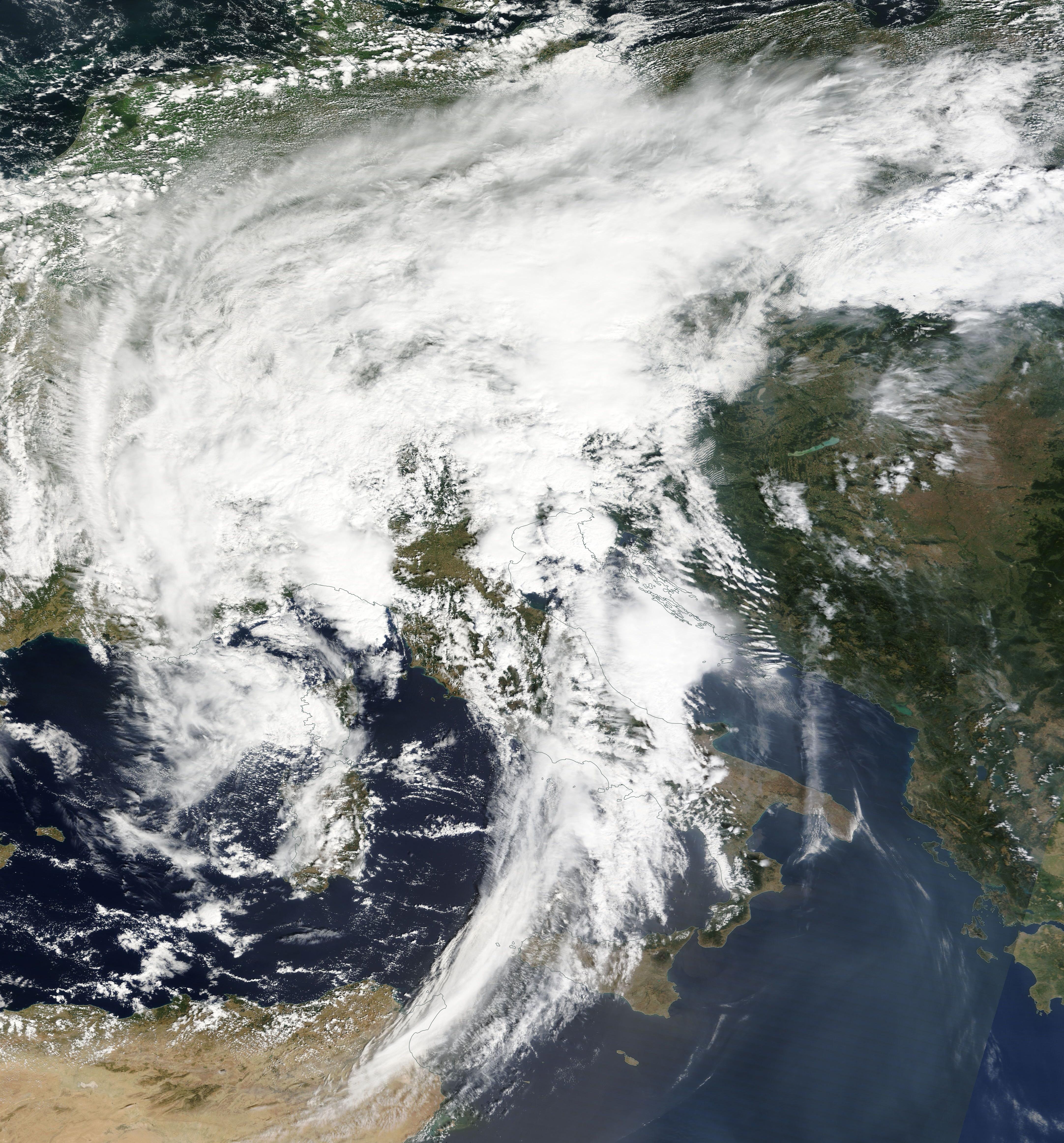
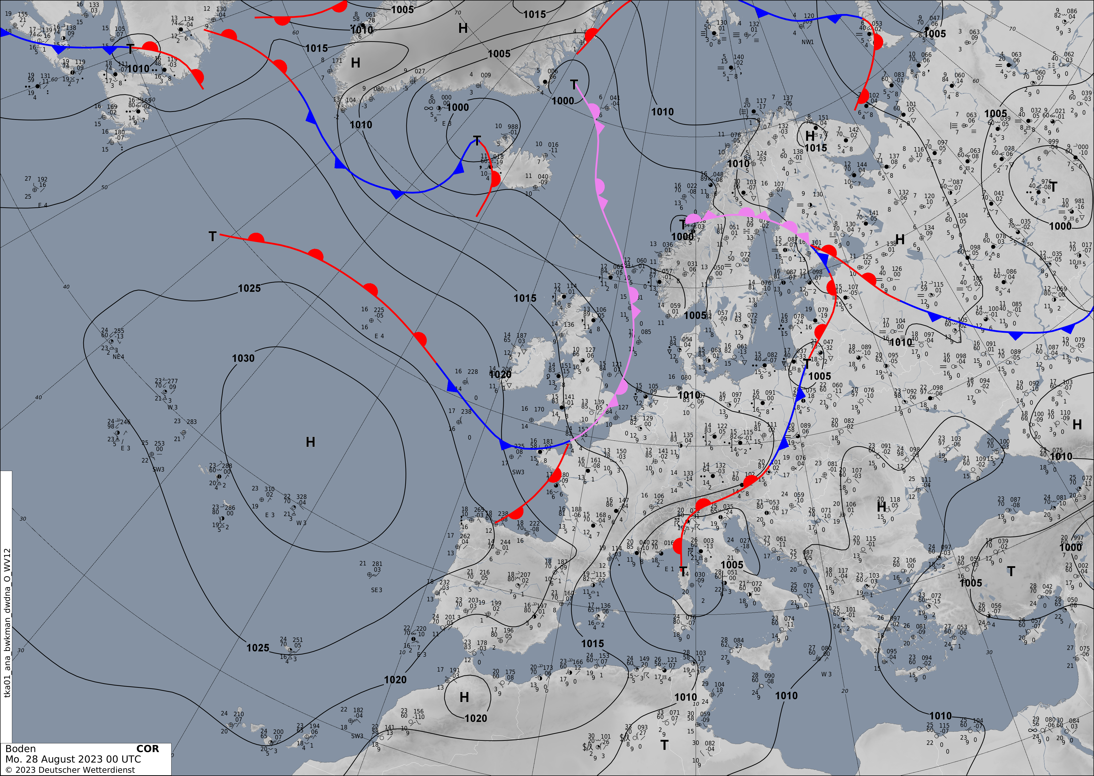
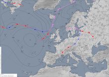
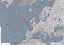
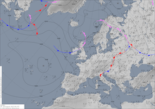
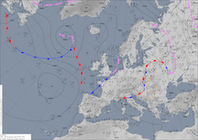
The trough over the North Sea led to a strong Mistral event in the Provence, which combined with the Lee cyclogenesis over the Gulf of Genoa caused hurricane-force winds across the Western Mediterranean. The developing surface low over the Gulf of Genoa in combination with the upper-level trough advected very moist air masses from the Mediterranean into the southern Alps.
|
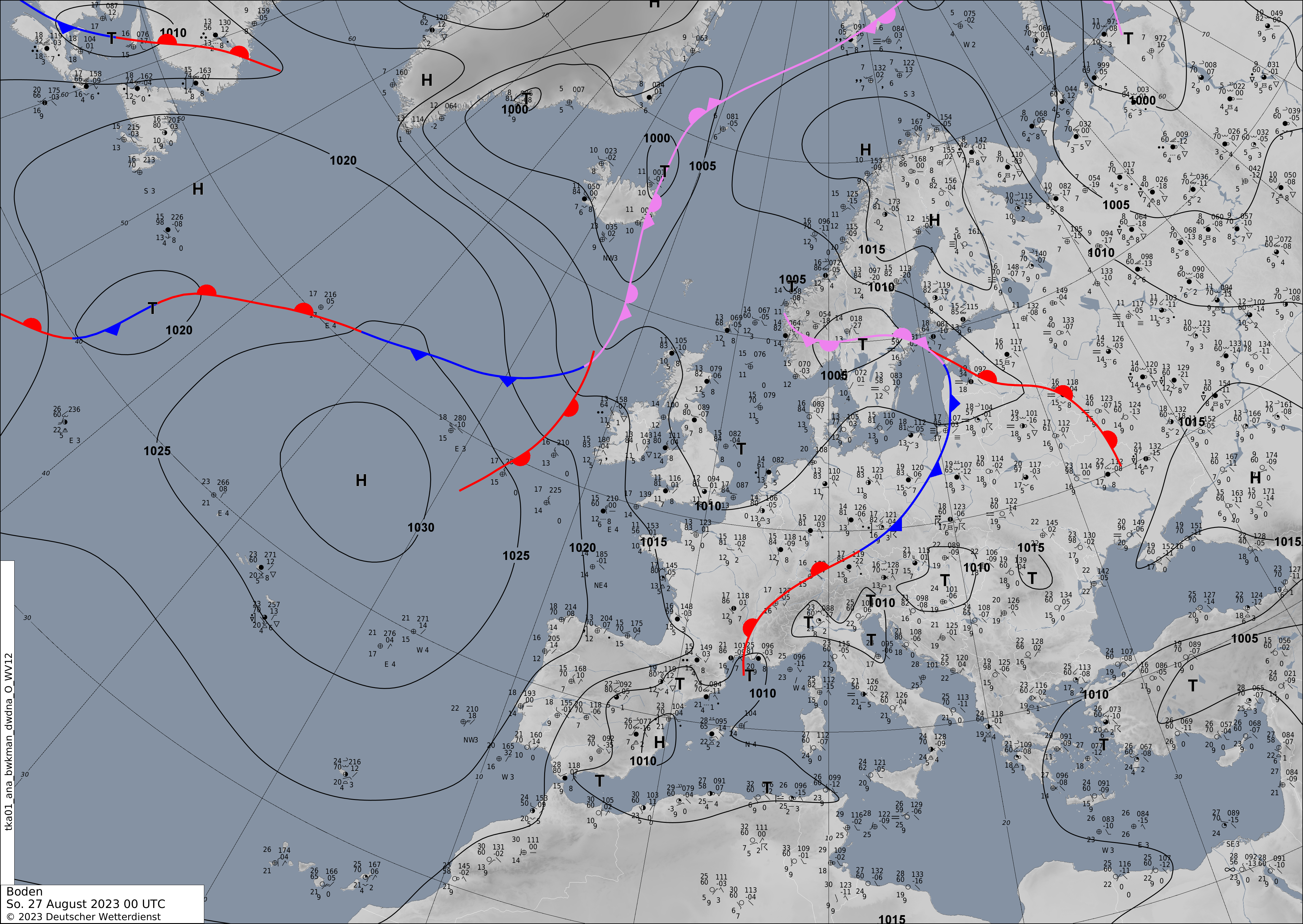
500 hPa Geopotential (upper row), 850 hPa pseudo-potential temperature (middle row), source:
wetter3 (both), and surface weather analysis (bottom row) and sea surface pressure over Europe, 27.08.2023 - 30.08.2023, source:
DWD
|
 |
 |
 |
 |
 |
 |
 |
 |
 |
 |
 |
 |
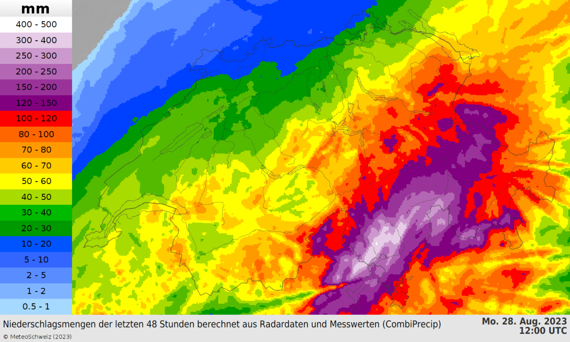
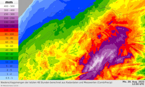
By the early afternoon hours, heavy downpours were observed along the Southern Alps, with the most intense precipitation affecting the Swiss Canton of Ticino and the Canton of the Grisons. Within a 48 h-period widespread precipitation totals reached up to 200 mm, with the highest precipitation total of 368 mm/48 mm being observed in the town of Biasca. Radar analysis suggests that localized more than 400 mm/48 h of precipitation have fallen.
|
48 h accumulated precipitation, 28.08.2023 12 UTC (left), and return period for the observed 48 h precipitation totals (right) over Switzerland, 26.08.2023 - 27.08.2023, source:
MeteoSchweiz
|
 |
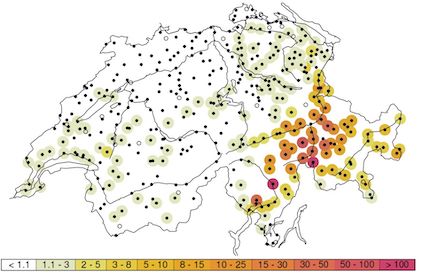 |
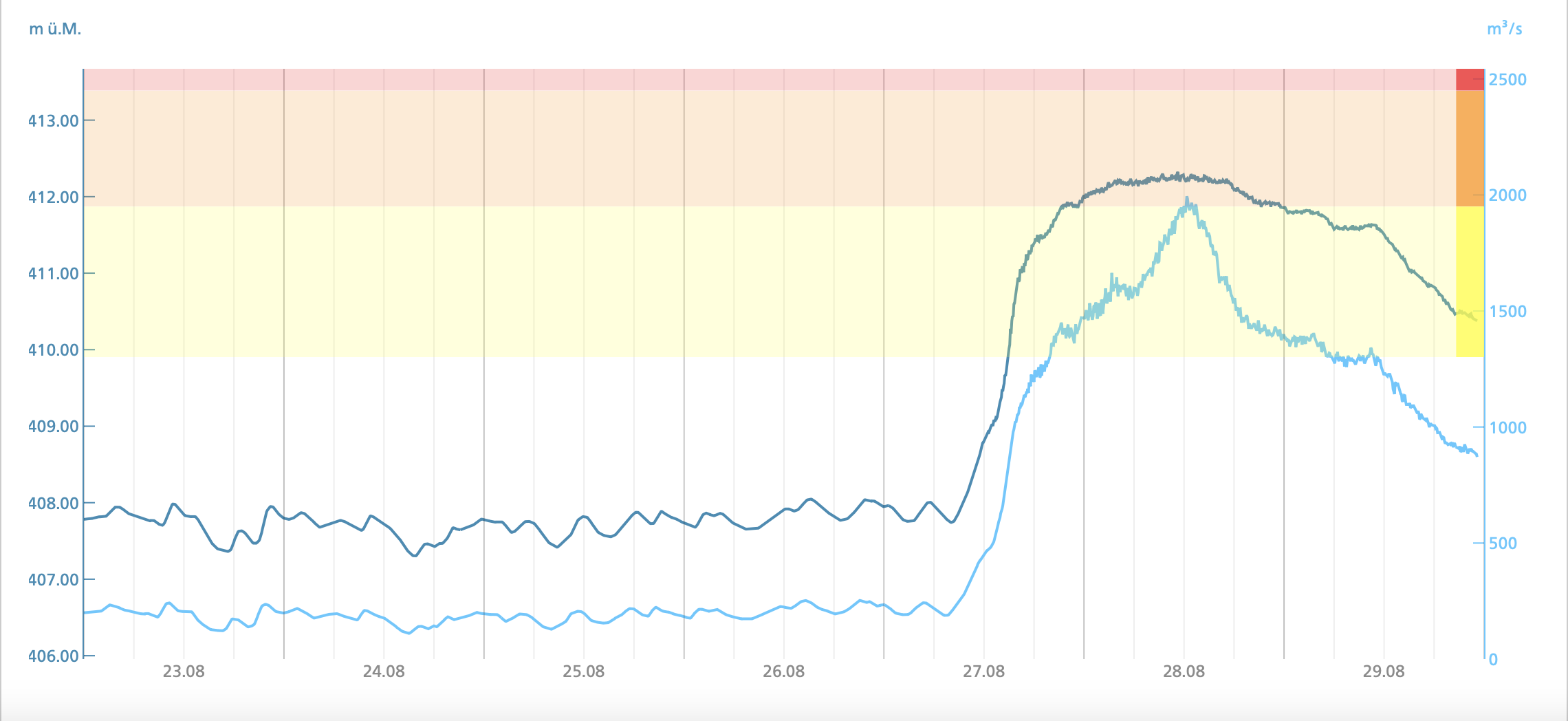
On average precipitation totals of around 200 mm/48 h are observed in this region on average once every 3 to 8 years. In the town of Biasca, the return period is larger than 100 years. In the Canton of the Grisons, the observed 48 h precipitation totals occur on average every 30 to 50 years. The heavy rains led to very strong run-off feeding into the Alpine Rhine, causing river flooding. However, as the snow melt in the Alps this late in the year is nearly complete, river levels did not reach extreme flooding stages.
|
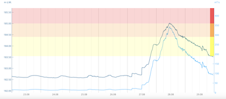
River level and flooding stages of the Inn at Tarasp (left) and of the Rhein at Diepoldsau, Rietbrücke (right), 23.08.2023 - 29.08.2023, source:
Bundesamt für Umwelt
|
 |
 |
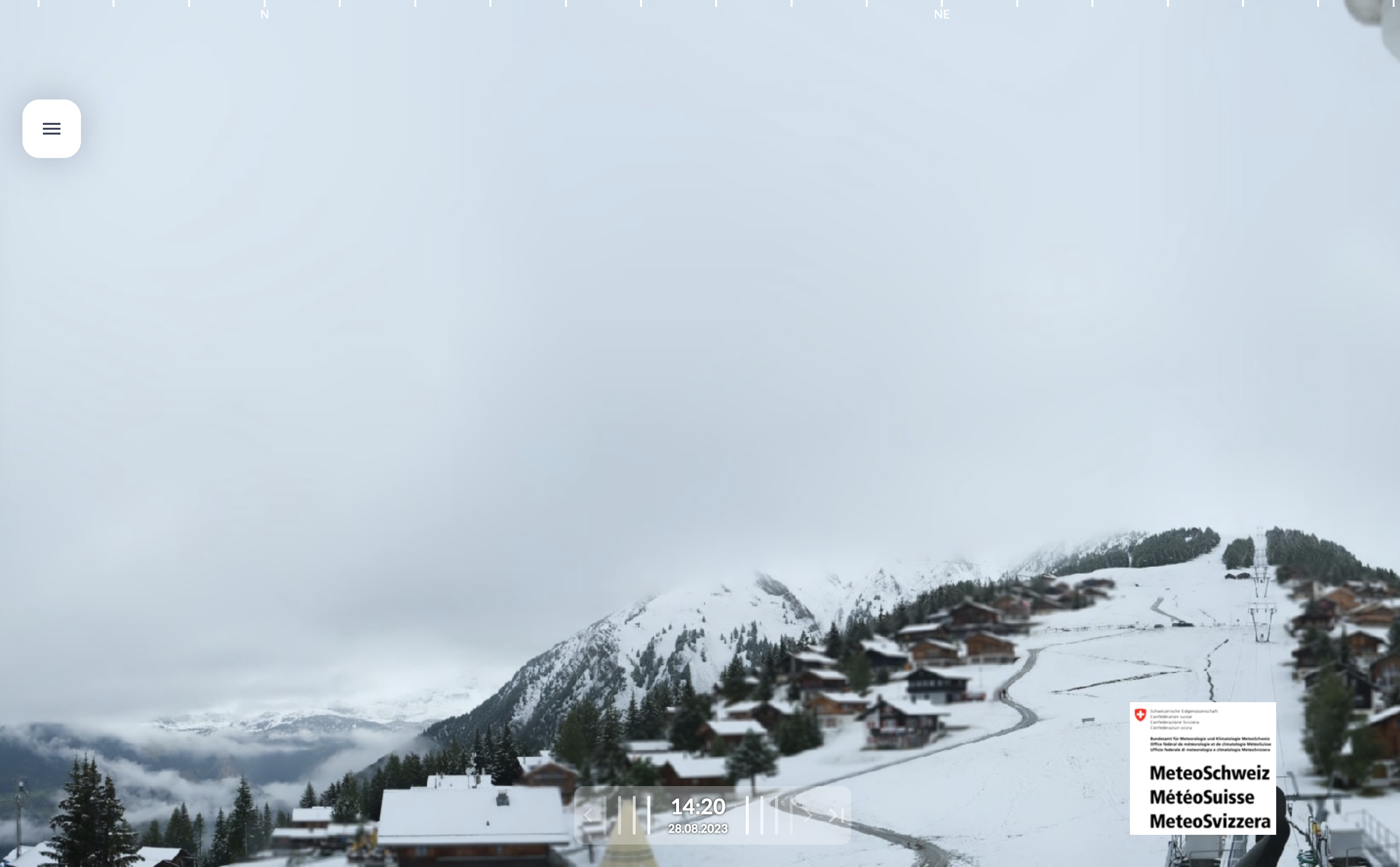
In some Swiss valleys north of the main chain of the Alps, the intense precipitation led to extreme temperature swing within a few days. On August 24, 2023, the Swiss town of Zermatt at an altitude of more than 1600 m above sea level reached a temperature of 31,2 °C. On August 28, 2023, the temperatures started to drop to freezing level due to an intense precipitation cooling effect, which was exacerbated by the confined valley the town lays in. Heavy snow started to fell in the town marking an unusually early start to the winter season with the first snow. At higher elevations, significant snow totals were observed in the western part of Switzerland, with the snow line dropping to 2000 m.
|
Snow cover at Rosswald at an altitude of 1830 m above sea level, 28.08.2023 12:20 UTC, source:
MeteoSchweiz
|
 |
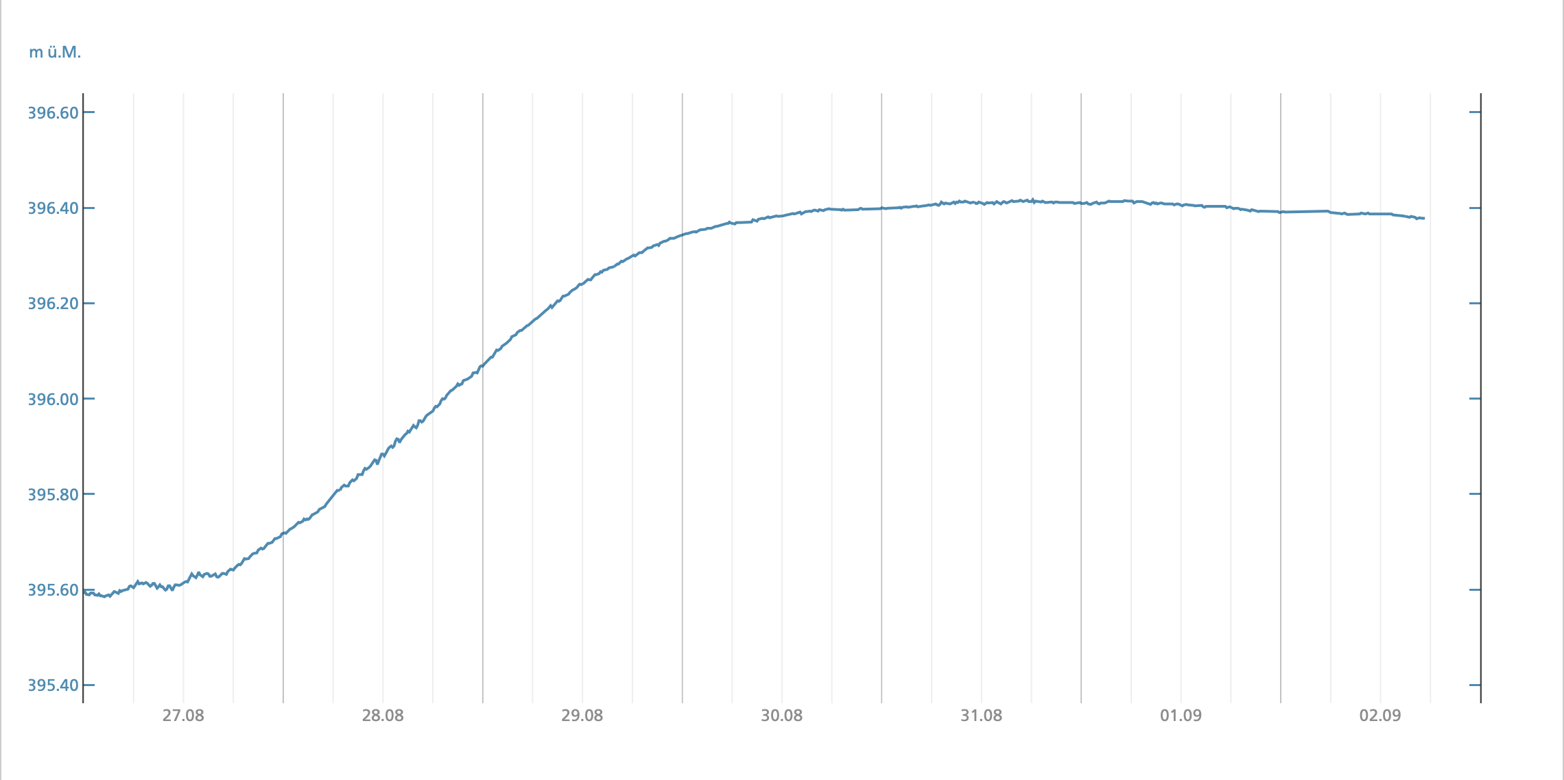
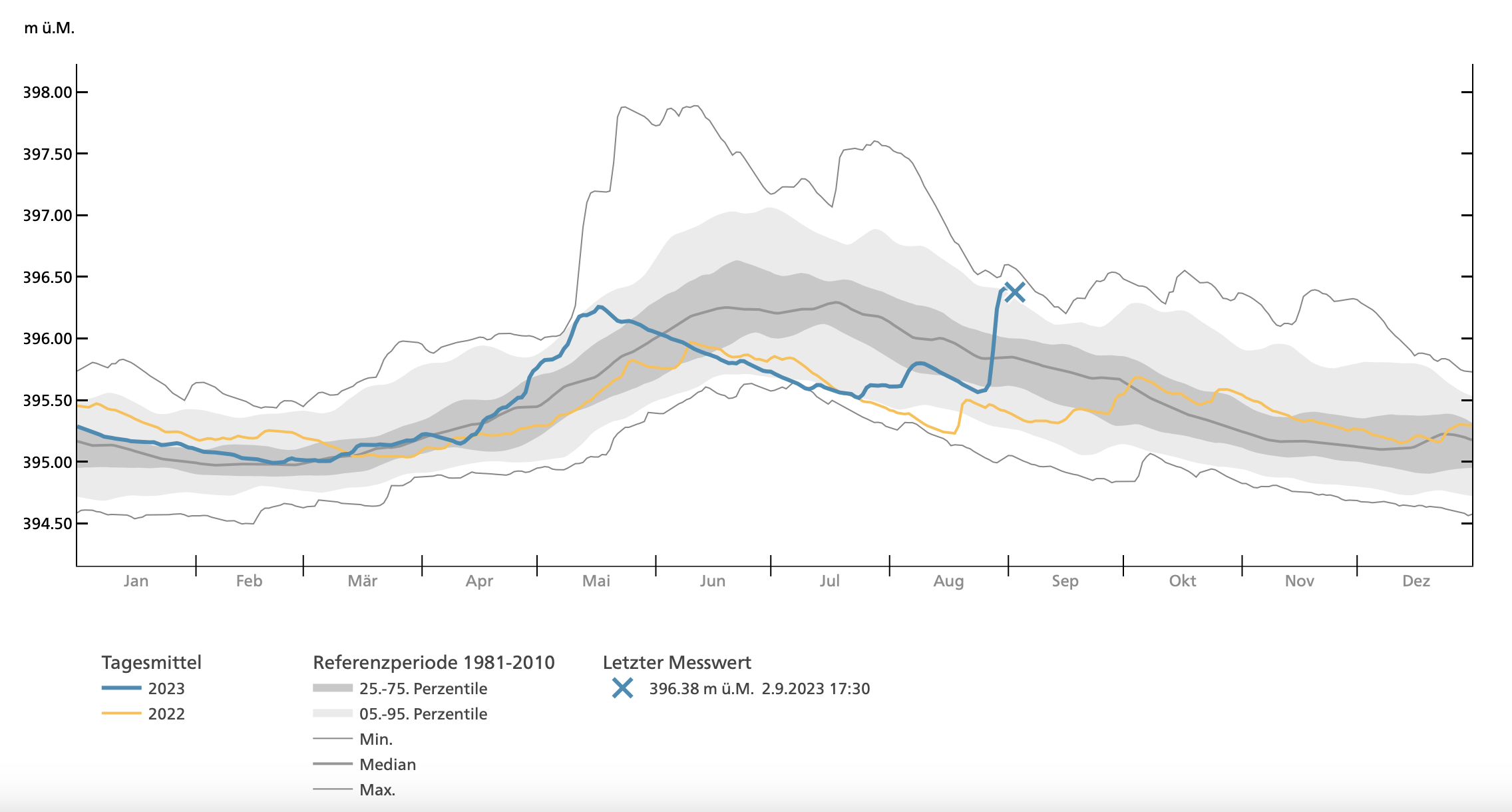
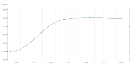
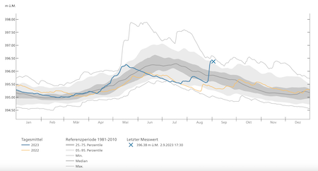
The high water spread downstream along the Alpine Rhine, reaching Lake Constance. Here, the enormous precipitation which well in Switzerland led to a fast increase in the lake level. Within a 72 h-period, the lake level of Lake Constance rose by up to 80 cm, which roughly accounts for 420.000.000 m3 of water influx, nearly 1 % of the lake’s total water content. Lake levels, as high as currently, are rare at the end of summer when the water level in Lake Constance approaches its Fall minimum. Downstream of Lake Constance, no river flooding was observed along the High Rhine. However, the river levels of the Rhine increased substantially from below-average conditions to above average run-off conditions for the season.
|
Lake level of Lake Constance at Romanshorn, 27.08.2023 - 02.09.2023 (left) and yearly overview (right), source:
Bundesamt für Umwelt
|
 |
 |
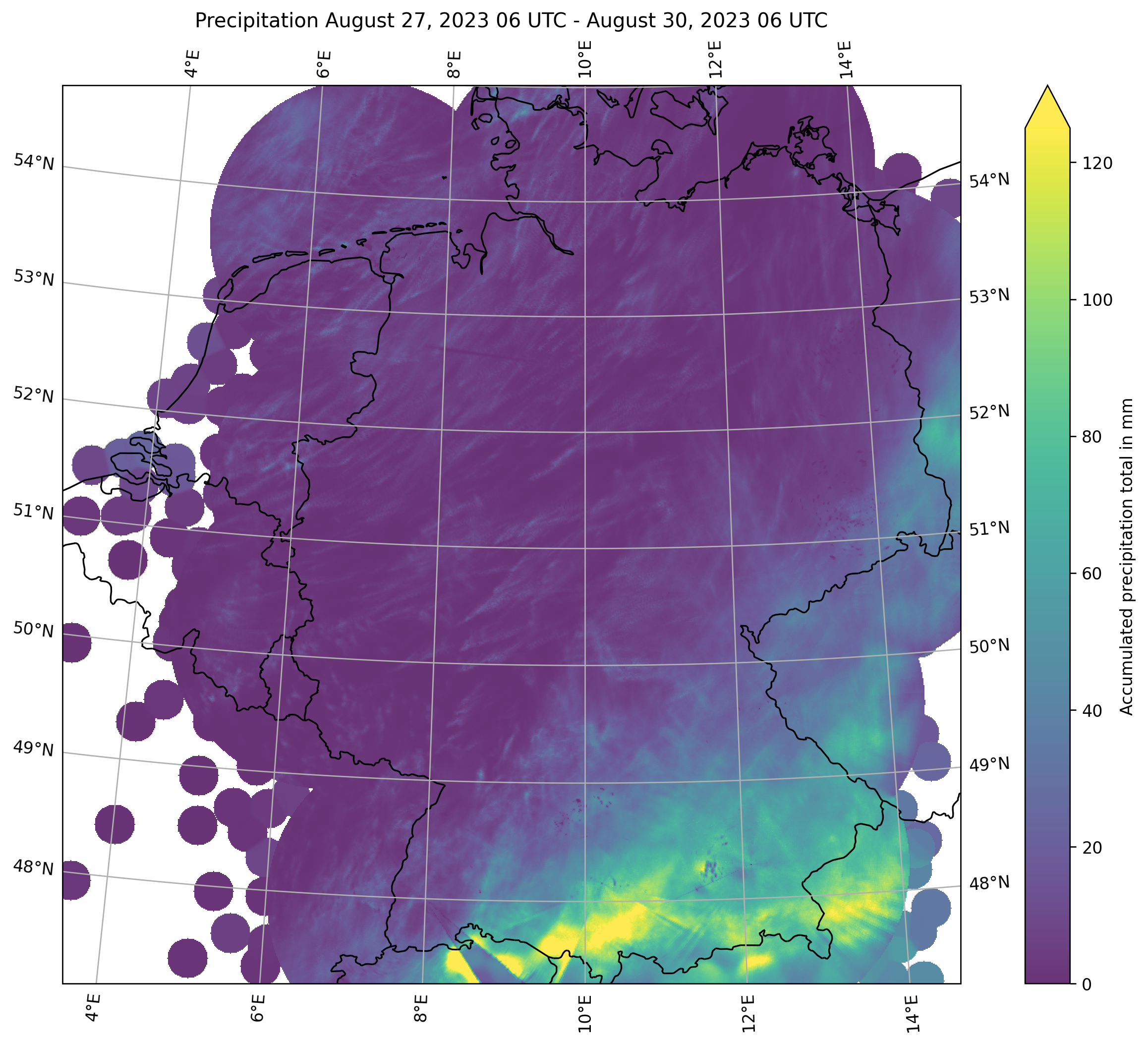
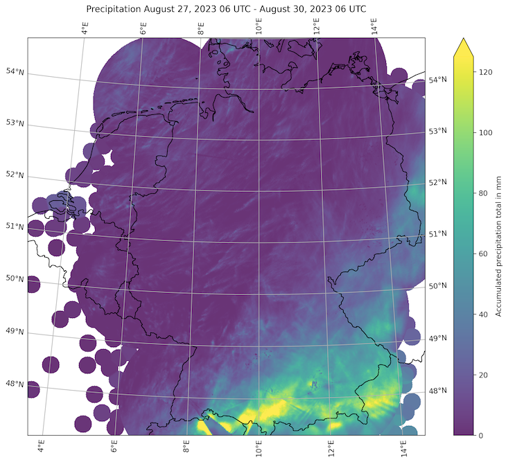
On August 27, 2023, the heavy rain started to spread across the Alps as the surface low moved northeastwards into Northern Italy. Heavy precipitation fell throughout Austria and spread into Southern Germany. Over Southern Germany, the highest precipitation totals were observed south of the Danube River. Widespread precipitation totals reached more than 100 mm within a 48 h-period. In Austria, the highest precipitation totals were observed in the States of Vorarlberg and Tyrol. 48 h precipitation totals reached up to 220 mm in the town of Fraxern.
|
72 h precipitation total over Germany, 30.08.2023 12:20 UTC, source:
DWD, Visualization: K. Gramlich
|
 |
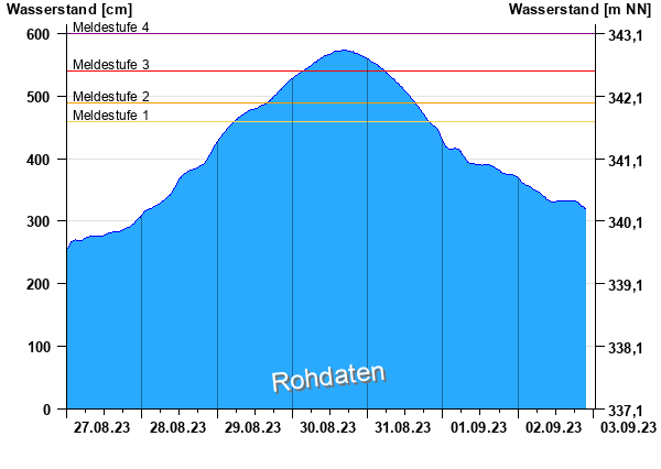
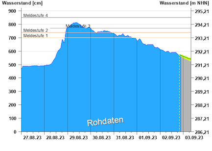
As a result of the extreme precipitation, many rivers feeding into the river Inn ran at exceptional flooding stages, with multiple hundred-year floods being observed. The worst flooding occurred in the Ötztal in Tyrol, where the Ötztaler Ache significantly surpassed the 100-year returning period. This resulted in the wash-out of the street connecting the Ötztal with the Inn Valley, leaving the towns within the valley being cut off from the outside world. The known skiing destination of S&omul;lden at the end of the Ötztal was affected the worst, with the only open roadway leading across a pass into South Tyrol. Along the river Inn, the flood spread downstream, at the town of Magerbach a hundred-year flood of the Inn was observed. In Innsbruck, the Inn reached the highest river level in almost 20 years. Further downstream, the river flood slowly dampened. Only in the town of Passau, where the Inn flows into the Danube River, the Danube river levels reached nearly 8 m.
|
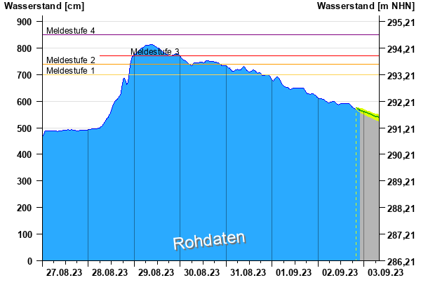
River level and flooding stages of the Danube at Kelheim (left) and at Passau Ilzstadt (right), 27.08.2023 - 02.09.2023, source:
HND Bayern
|
 |
 |
In the Alps, the heavy precipitation led to many rock- and landslides which blocked many roadways and train tracks in the Alps. In the Western Mediterranean, severe convective activity was observed, induced by the lee cyclogenesis. By August 29, 2023, the heavy precipitation ceded across the Alps, leading to quickly receding river levels. Nevertheless, in parts of Tyrol, the damages by the river flooding were extensive, with multiple roads being washed out. Throughout, the Alps this very strong precipitation event contributed to a very wet August, all the while a prolonged heat wave during the second half of the month led to many new temperature records in the Alps. Remarkably, a radiosonde launched at the Swiss town of Payerne recorded the highest freezing level on record in Central Europe on August 21, 2023, with an altitude of 5298 m above sea level.
Text: KG
September 02, 2023
|