Heat wave, Severe thunderstorms Central Europe
07 - 12 July 2023
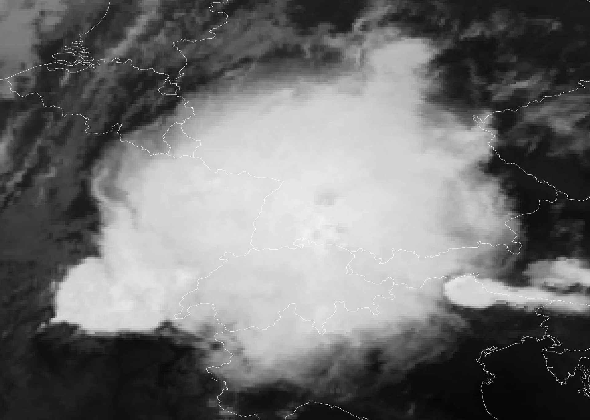
Infrared satellite imagery of a ginormous MCS over Central Europe, 11.07.2023 21 UTC
Source: Eumetsatview
The combination of a trough over the Eastern Atlantic and a ridge extending from the Iberian Peninsula into Central Europe led to sweltering heat in many parts of Europe. In the Central Europe, this led to the first major heat wave of the summer 2023, with temperatures reaching 38,0 °C in Waghäusel-Kirrlach, BW. On July 11, 2023, severe thunderstorms developed, accompanied by extreme convective downdrafts of up to 144,5 kph at the Uetliberg-Turmspitze, CH close to Zürich.
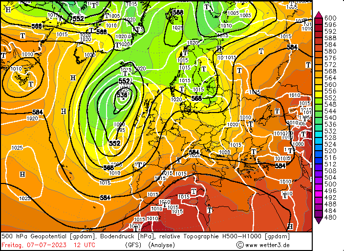
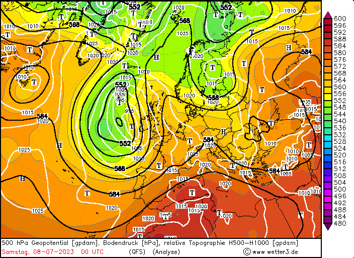
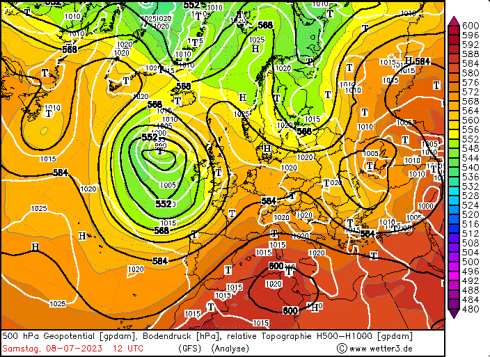
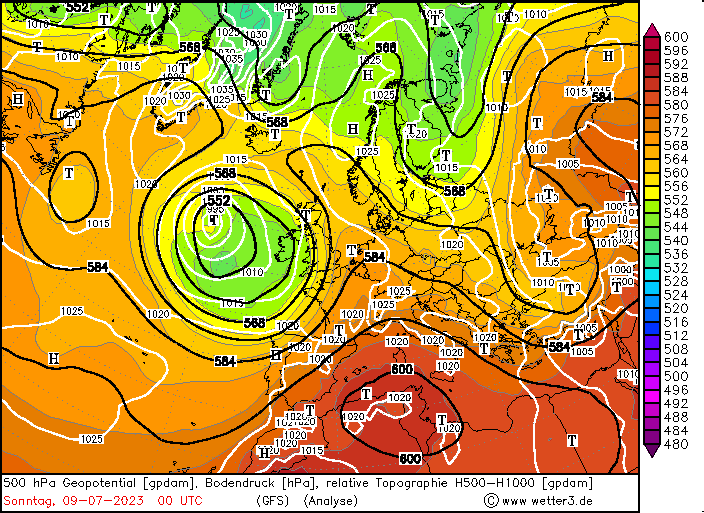
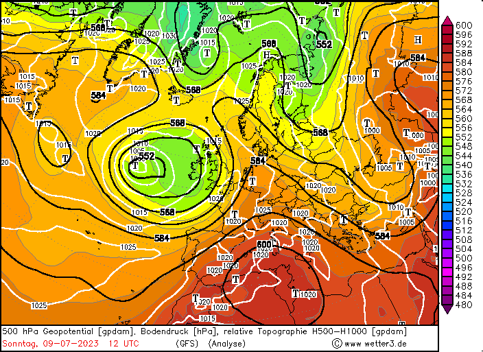
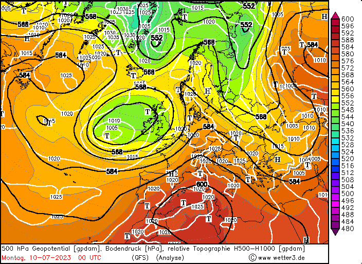
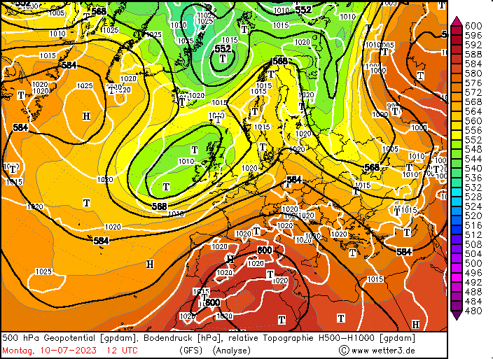
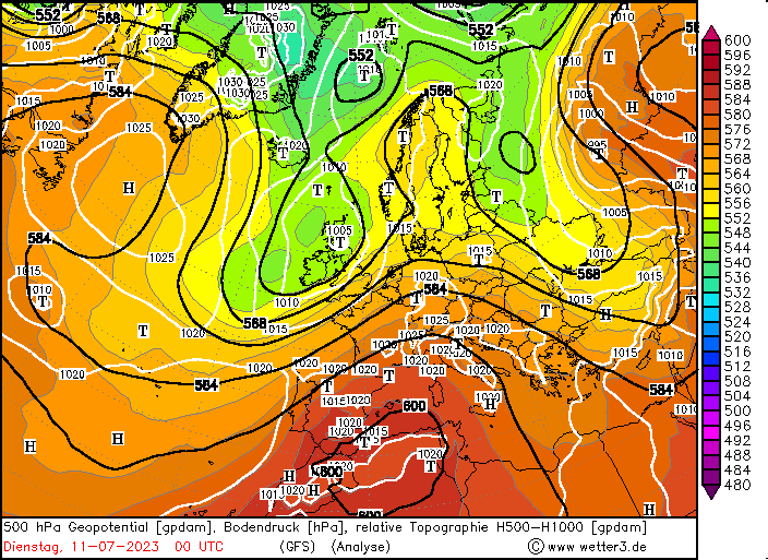
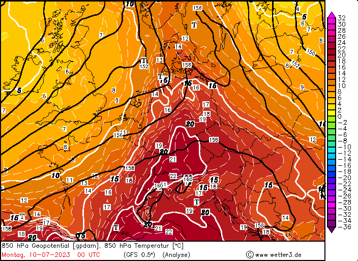
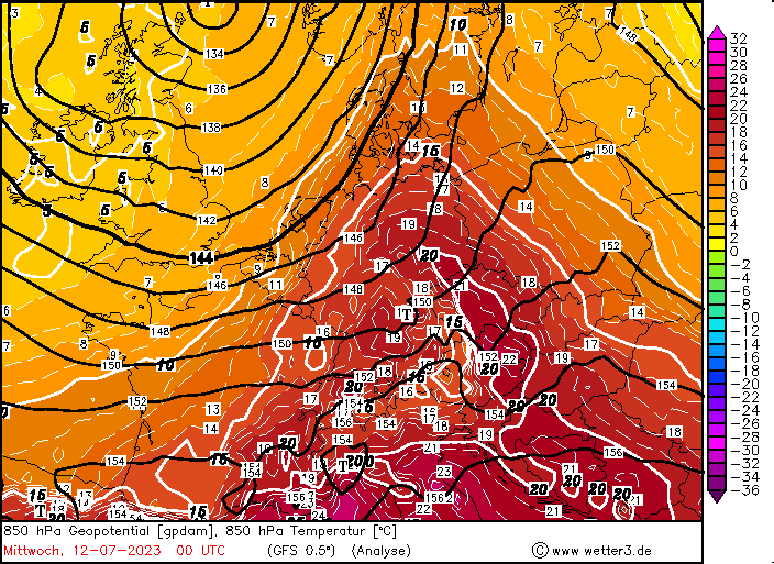
For the first days of the month a trough above the North Sea dominated the synoptic situation over Europe, by July 07, 2023, a cut-off formed above the Eastern Atlantic west of the British Isles. Above Europe, the formerly zonal flow pattern was disturbed and a ridge stretching from the Iberian Peninsula into Southern Scandinavia formed downstream of the trough, which lead to the advection of very warm air masses from Northern Africa into Europe. In Central Europe 850 hPa temperatures reached more than 20 °C, as air masses from the Mediterranean were advected into Central Europe.
500 hPa Geopotential and sea surface pressure over Europe 07.07.2023 12 UTC - 11.07.2023 00 UTC, source:
wetter3
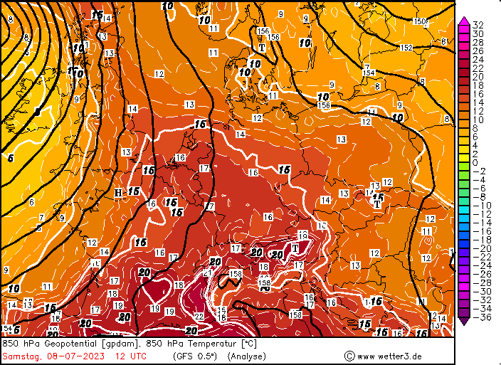
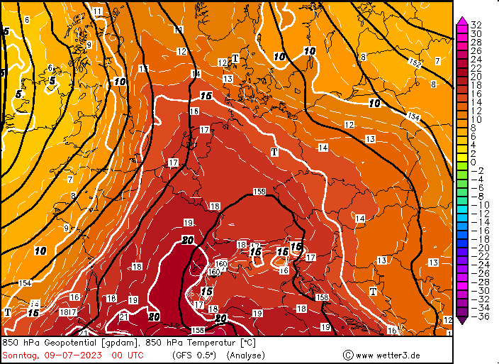
By July 07, 2023, the day-time maximum temperatures in the Upper Rhine Plain reached already more than 30 °C. By July 09, 2023, the nearing trough above the British Isles amplified the advection of very warm air masses into Central Europe with 850 hPa temperatures peaking at more than 20 °C in Southern Germany. The weather station at Waghäusel-Kirrlach, BW recorded with 38,0 °C the warmest temperature of the year 2023 in Germany thus far. Though, a non-DWD station in Bavaria measured 38,4 °C ahead of the severe weather outbreak in June.
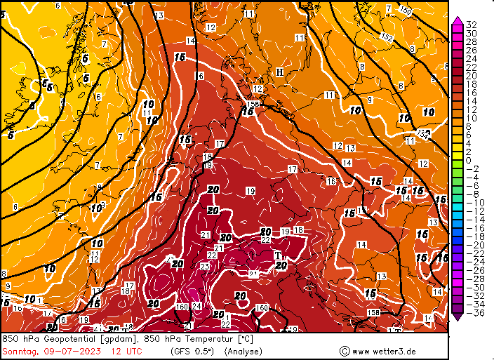
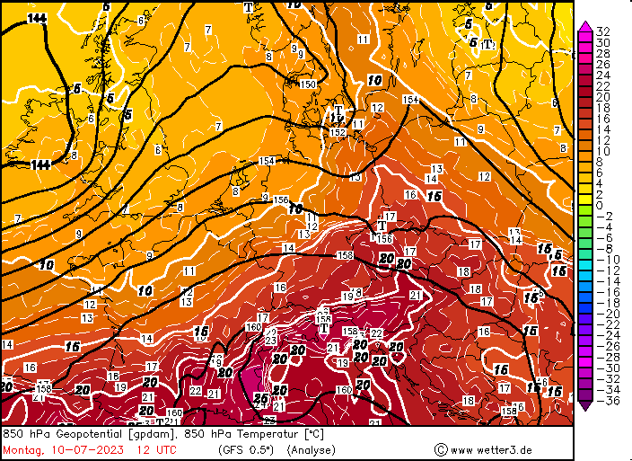
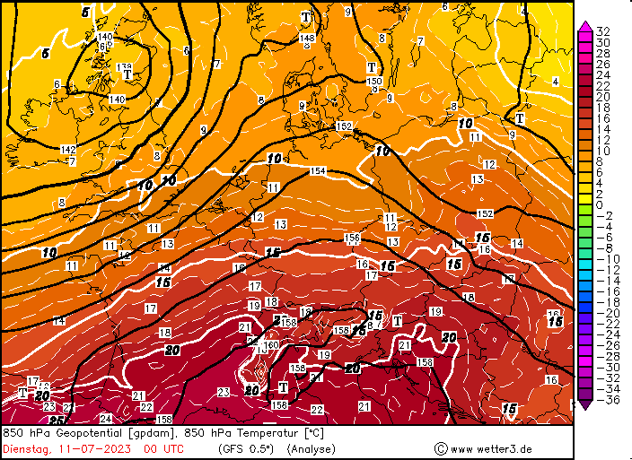
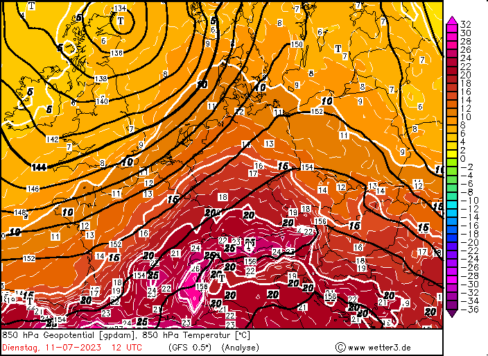
850 hPa temperature and sea surface pressure over Central Europe 08.07.2023 12 UTC - 12.07.2023 00 UTC, source:
wetter3
In the afternoon and evening, a cold front passed over Germany, bringing widespread convective activity to the northwestern half of Germany with locally heavy downpours and strong convective downdrafts with wind gusts of up to 100 kph. Behind the cold front, 850 hPa temperatures dropped by 5 - 10 K. Nevertheless, the temperatures remained above the 30 °C-mark in the southern part of Germany, especially in the Upper Rhine Plain.
With the trough above the British Isles nearing Central Europe, the advection of very warm air masses from the Mediterranean was once again increased on July 11, 2023, with 850 hPa temperatures reaching more than 20 °C in the southern part of Germany. A secondary heat peak was observed on July 11, 2023, with temperatures remaining around 1-2 K lower than the highs recorded two days prior. The highest temperature of the day was recorded in Möhrendorf-Kleinseebach, BY with 37,2 °C.
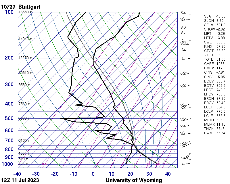
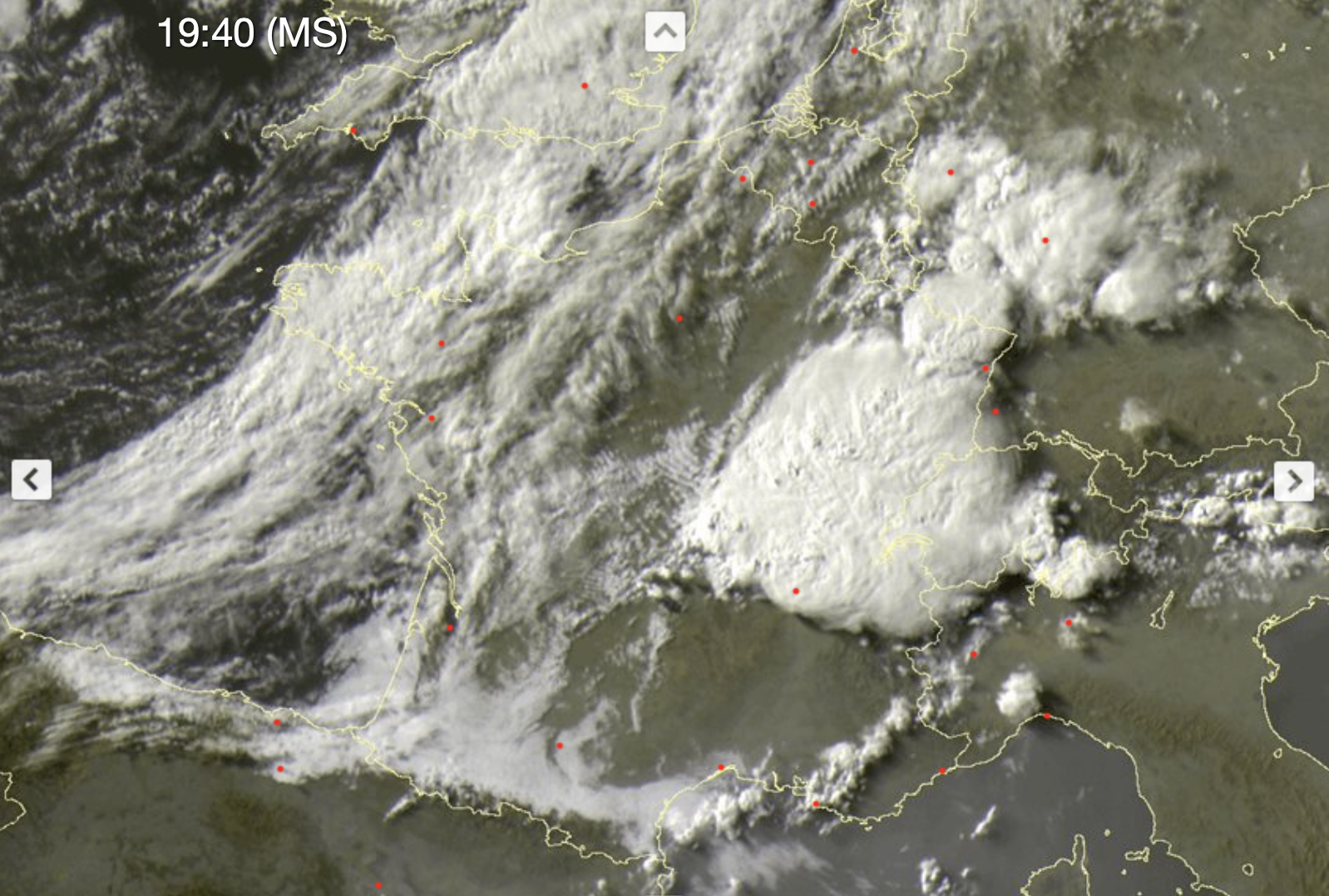
The combination of the nearing trough and the strong solar insolation above Central Europe on July 11, 2023, provided a beneficial environment for severe thunderstorm development in the afternoon hours. At the southern flank of the trough above the British Isles, a secondary trough developed, quickly moving northeastwards across France into Germany, providing mid-level lifting first above France, and later shifting into Germany. The 12 UTC soundings across Southern Germany already showed abundant CAPE with Mixed Layer CAPE > 1000 J/kg and a high boundary layer stretching up to 800 hPa. A first batch of thunderstorms developed to the southeast of Paris by 13 UTC moving northeastwards into the Grand Est and the western part of Germany. Locally, these thunderstorms brought large hail and heavy downpours. In Asweiler, SL heavy winds damaged multiple residential buildings, a weak tornado is suspected to have formed above the town, though, a strong microburst as the cause of the wind damage cannot be excluded at this time. By 13 UTC, first strong convective cells formed downstream of the Massiv Central moving into the Rhône-Valley. In the following hours, the thunderstorm activity quickly intensified in the region, with many strong singular cells forming a ginormous cluster system. The cirrus plume of the system covered more than a quarter million square kilometers, stretching across France, Germany, Switzerland, Austria, and Italy. Single overshooting tops embedded into the cluster, reached cloud top temperatures below -70 °C, implying cloud top heights of more than 12 km.
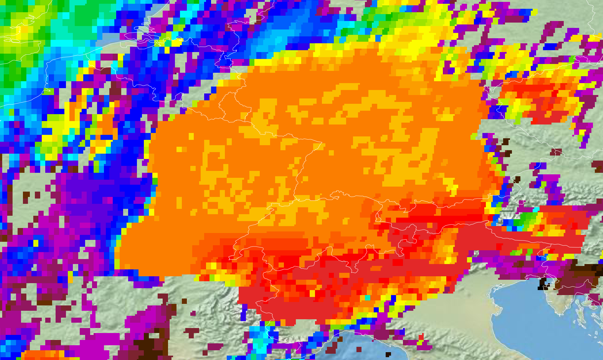
Visible satellite image, 11.07.2023 17:40 UTC (left), source: Sat24, and cloud tops height, 11.07.2023 17:45 UTC (right)
Eumetsatview
In the early evening hours, the cluster intensified as it moved above the Saône-Plain. At the leading edge of the cluster, a strong squall line formed, likely triggered by the convective outflow of the ageing cells upstream of the squall line. By 18 UTC, the mesoscale convective system (MCS) moved into the High Rhine area. After passing Zürich, a distinct squall line embedded in the MCS formed, stretching around 150 km to the northwest into the Alsace, moving northeastwards. Especially in the Swiss Plateau, the squall line brought hurricane force wind gusts over a large area, with wind gusts peaking at 144,5 kph at the Uetliberg-Turmspitze, CH close to Zürich. Both to the north and the south of the squall line embedded in the MCS strong single thunderstorms formed above the Black Forest and the Alps, bringing locally large hail and heavy downpours.
In the first half of the night, the squall moved northeastwards above Lake Constance into the Alpine foothills. Most stations in the Alpine foothills registered triple digits wind gusts with the arrival of the squall line, many recording hurricane-force wind gusts. Very high DCAPE values of around 1000 deg;C favored the formation of strong density currents with these thunderstorms. Both the observatory at Hohenpeißenberg, BY and the weather station up on the Feldberg mountain, observed their respective strongest wind gusts in the recorded history of the month of July, with a 133,2 kph gust at Hohenpeißenberg and a 142,6 kph gust at the Feldberg, BW. Overall, 16 stations in Baden-Württemberg and Bavaria observed the highest wind gust in the recorded history with the passage of the squall line on July 11, 2023.
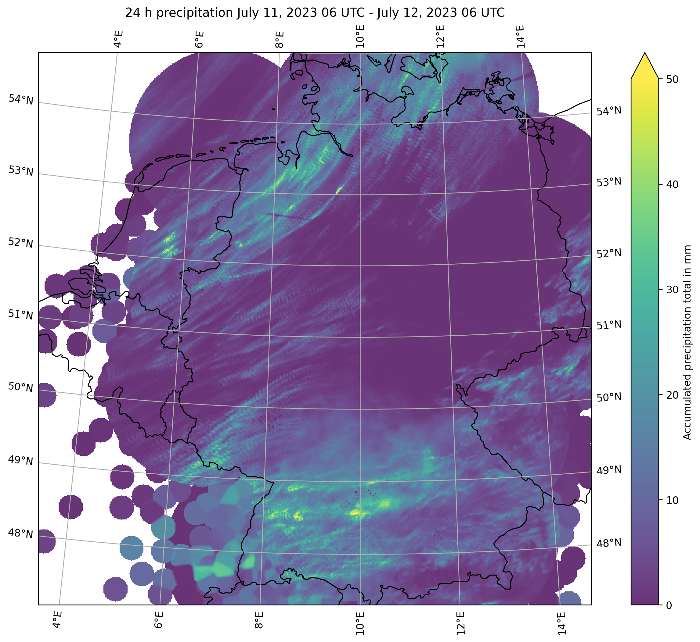
24 h precipitation totals over Germany between 11.07.2023 06 UTC - 12.07.2023 06 UTC, source: DWD, visualization: K. Gramlich
Heavy downpours were also embedded in the cluster with hourly precipitation rates of up to 43,6 mm in Haigerloch-Weildorf, BW. By 00 UTC, the squall line had passed the entire Danube Valley, while gradually weakening after passing Munich. Behind the squall line, the distinct reflectivity trough is prominently visible in the radar images, along with the stratiform precipitation falling in the region of the rear inflow jet. In the evening hours, the outflow of the MCS triggered secondary thunderstorm formation to the north of the system, bringing localized downpours. Over Bavaria, the radar images also show the cyclonic flow induced by the MCS, with the precipitation field forming a miniature representation of the precipitation fields of an extratropical low.
🔵 Gestern Abend (am 11.07.2023) kam es in #Asweiler bei #Freisen im #Saarland zu erheblichen Schäden während einem Gewitter. Im Ort wurden mehrere Dächer teils komplett abgedeckt und Bäume entwurzelt. Es besteht der Verdacht auf einen #Tornado. Mehr zum Fall folgt noch. pic.twitter.com/rm23KeDaFc
Over Northern Germany the approaching cold front of the surface low beneath the trough led to the formation of a second, yet much weaker squall line, bringing heavy rains. Behind the cold front, localized thunderstorms developed during July 12, 2023.