Wednesday, 21 June 2023, 18:30 UTC
|

|
|
|
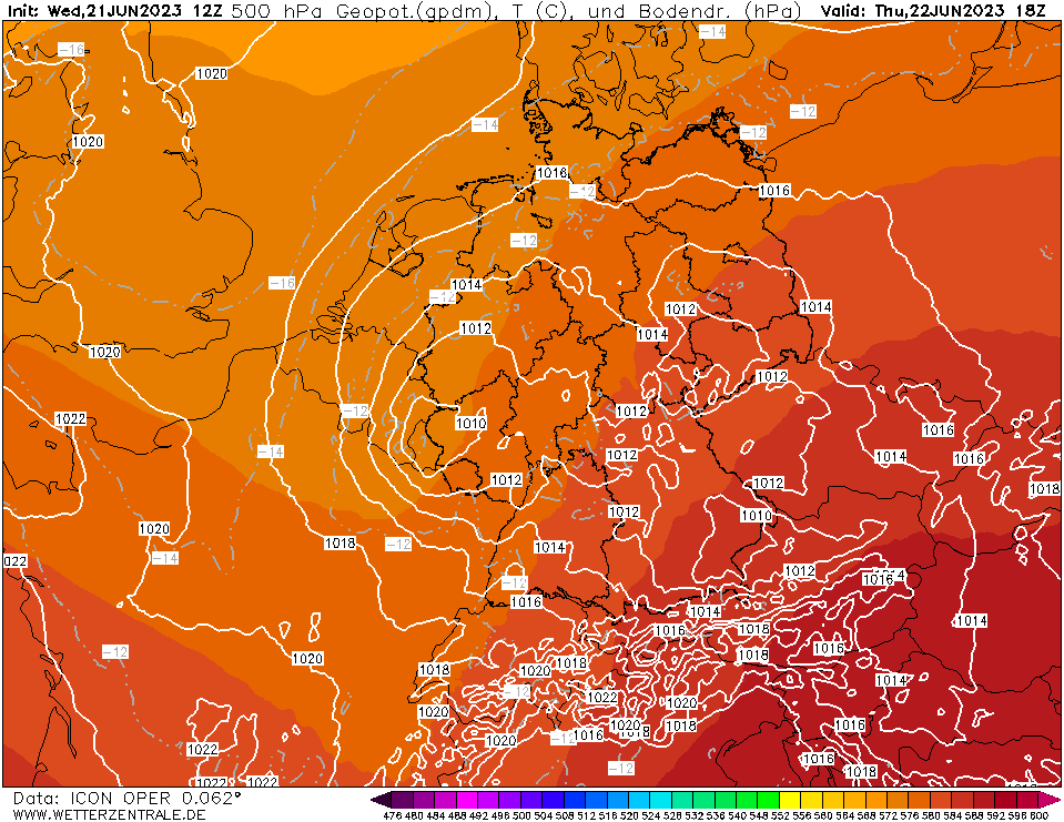
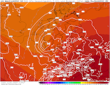
500 hPa Geopotential and sea surface
pressure Central Europe, 22.06 18 UTC
Source: wetterzentrale
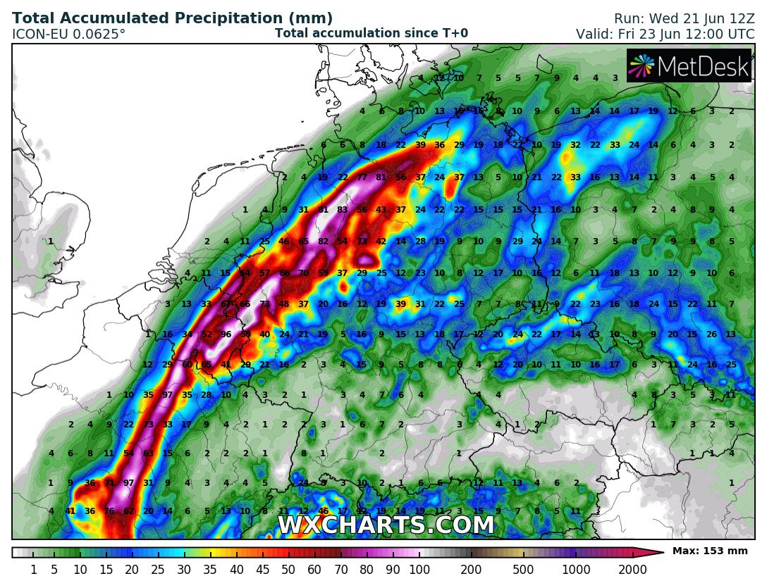
| Accumulated precipitation over Germany until
23.06 12 UTC
Source: wxcharts
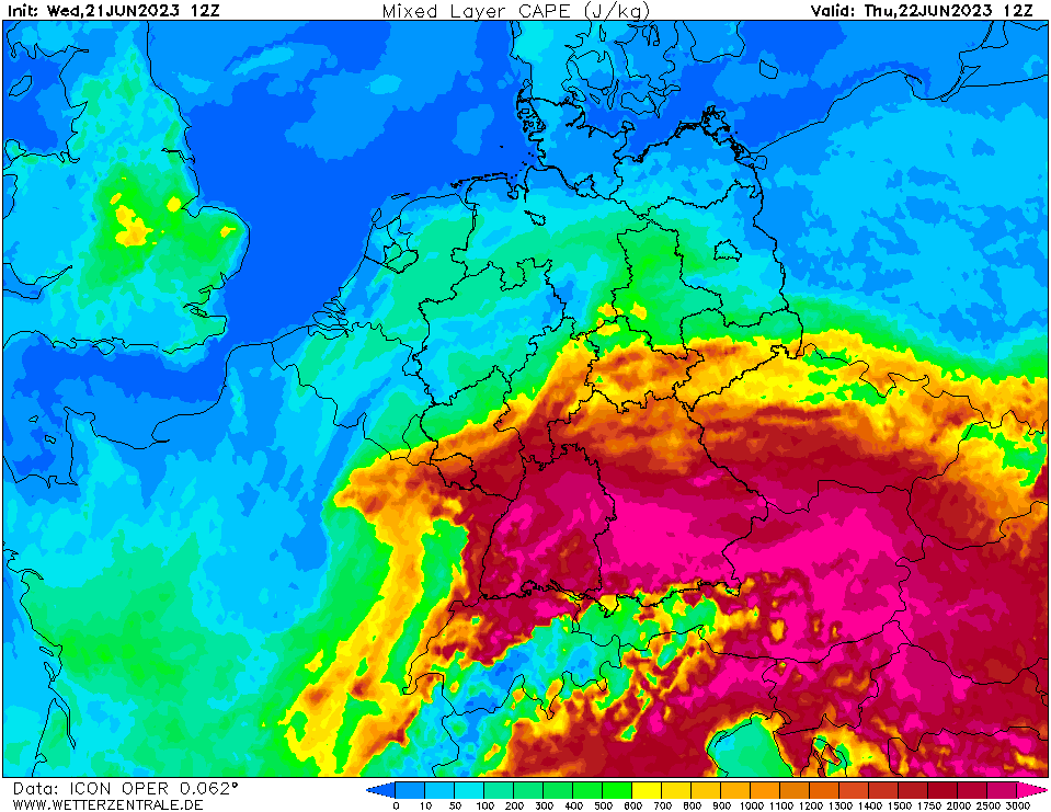
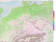
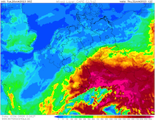
| Mixed layer CAPE Central Europe,
22.06 12 UTC
Source: wetterzentrale
|
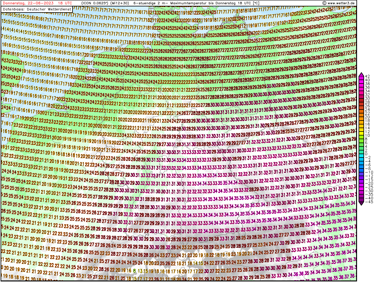
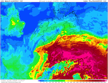
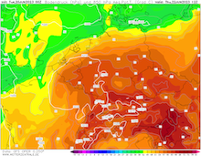
6 h Maximum temperature Central Europe,
22.06 18 UTC
Source: wetter3
|
Severe Thunderstorms, Heat
Central Europe
Issued: Wednesday, 21 June 2023, 18:30 UTC
A complex structure of a short-wave trough moving northeastwards from France into Germany as well as a small surface low developing ahead of the trough will likely induce severe convective activity over Central Europe on Thursday, June 22, 2023.
21.06.2023
At the southern tip of a trough over the North Atlantic, a short-wave trough has developed moving northeastwards across Western Europe. Subsequently, warm subtropical are advected into Central Europe ahead of the trough, with 850 hPa temperatures above the 20 °C-mark. Due to the complex nature of the synoptic situation, especially due to the interaction of the short-wave trough and the shallow surface low (core pressure only slightly below 1015 hPa), the prediction of the anticipated convective activity remains very challenging.
Ahead of convective activity tomorrow, the advection of very warm and humid into Central Europe is intensified, leading to sweltering heat across the southern part of Germany with day-time maxima potentially reaching 37 °C in the Alpine foothills, especially with the help of Föhn winds. Combined with very high dewpoints reaching locally more than 20 °C, the expected heat stress will be exceptionally high. Though, the temperature forecast is still highly uncertain, as convective activity across Southern Germany could potentially be triggered in the early afternoon hours, dampening the day-time temperature maxima.
The potential for severe thunderstorms is highly elevated from Thursday morning into Friday morning. Three distinct areas of convective areas will have to be monitored. First, along the tip of trough, a band extremely heavy rain mixed with severe convective activity is expected to impact Benelux states, moving northeastwards into North Rhine-Westphalia and across the Northern Lowlands of Germany. Here, the main concerns are very heavy downpours, as the atmosphere will be water loaded, with precipitable water reaching up to 40 mm. Hourly precipitation rates of more than 50 mm and 3 h precipitation totals of up to 100 mm must be expected, making flash-flooding likely, due to the recent dry-spell. In case trough has a more southeasterly trajectory across the German Uplands, small stream flooding along minor rivers in the German Uplands could be a concern, hotspot here would potentially be the Eifel and Sauerland mountains.
Directly to the southeast of the trough, the potential for widespread supercell activity is given as the trough moves across Northern Germany. The mid-level lifting of the trough will superpose above with the low-level shear of the shallow surface low, creating an enormous amount of shear. This will be accompanied very high CAPE values of up to 2000 J/kg, leading to Energy Helicity values greater than 2, locally more than 3 are possible. These thunderstorms can bring excessive precipitation as well as severe hail with diameters of multiple centimeters. Very damaging convective downdrafts of more than 120 kph are also possible. Locally, the formation of a tornado cannot be excluded, especially over the eastern part of Germany, as the models predict favorable hook echoes for supercell formation. On the cold side of the trough enduring heavy precipitation is expected, lasting into early Friday morning.
In the southern part of Germany, convective activity will likely be triggered in the Alps or the Swabian Jura, moving across the Danube valley on a northeasterly trajectory. Here, the thunderstorms will find an environment of exceptionally large CAPE values for Central Europe (> 3000 J/kg) due to the large day-time heating. Due to the decreased shear level, the potential for tornado formation in the southern part of Germany is slimmer but cannot be excluded as the supercells move northeastwards. Nevertheless, very large hail as well as heavy downpours and severe convective downdrafts with wind gusts upwards of 120 kph are likely.
Tuesday, 20 June 2023, 07:00 UTC
|
|
|
|
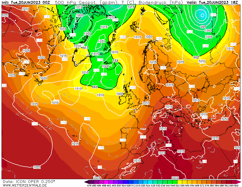
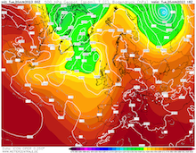
500 hPa Geopotential and sea surface
pressure Europe, 20.06 18 UTC
Source: wetterzentrale
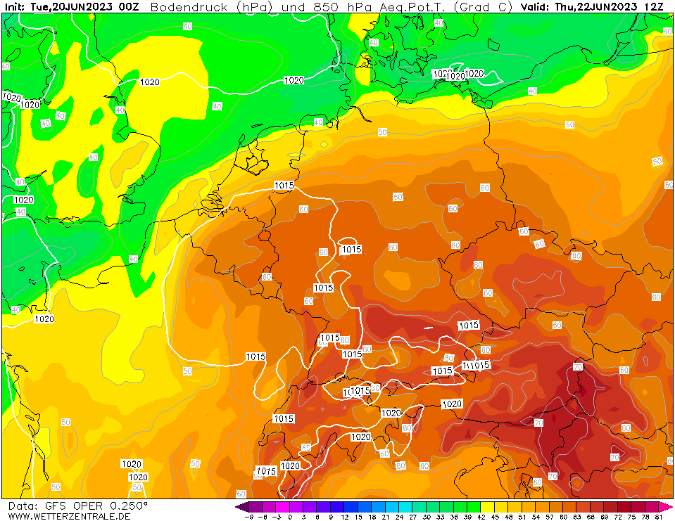
| 850 hPa Pseudo-potential temperature and
sea surface pressure Central Europe,
22.06 12 UTC
Source: wetterzentrale
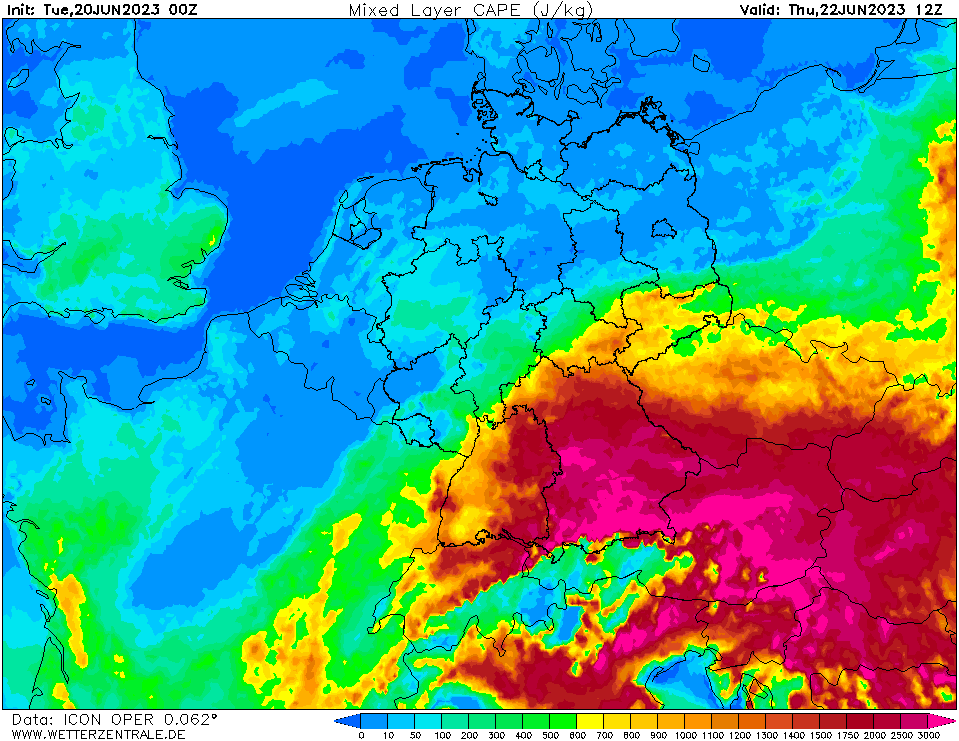
| Mixed layer CAPE Central Europe,
22.06 12 UTC
Source: wetterzentrale
|
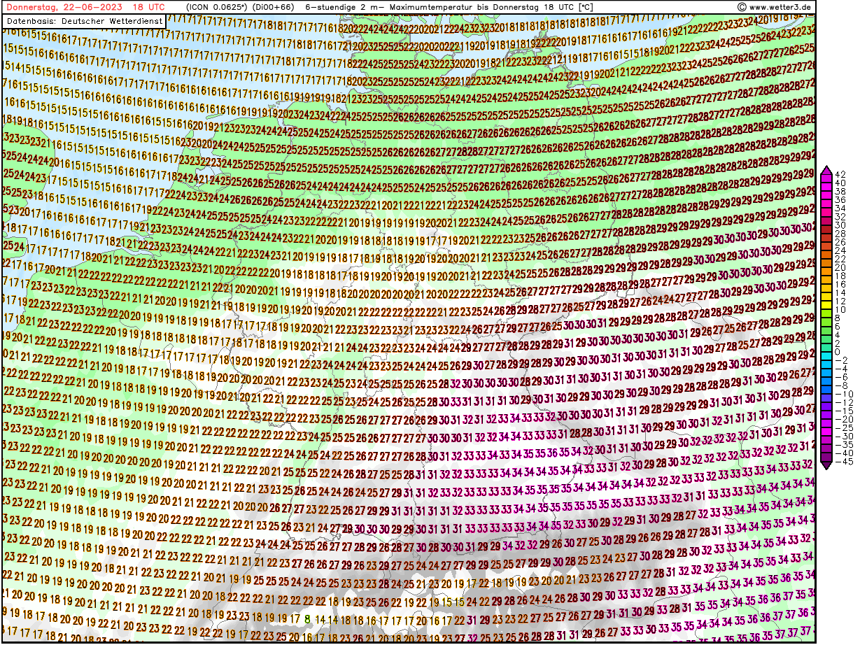
6 h Maximum temperature Central Europe,
22.06 18 UTC
Source: wetter3
|
Severe Thunderstorms, Heat
Central Europe
Issued: Tuesday, 20 June 2023, 07:00 UTC
Consecutive small upper-level troughs are expected to induce severe thunderstorm activity over Central Europe with heavy downpours, large hail, and damaging wind gusts. Ahead of the troughs severe heat with temperatures rising up to 35 °C is expected.
20.06.2023
At the southern tip of a trough structure between the British Isles and Iceland, consecutive upper-level troughs are expected to form in the coming days. Ahead of the trough, the advection of moist and very warm air masses from the Mediterranean is expected to be further enhanced, leading to sweltering heat in large parts of Central Europe with day-time maxima above the 30 °C-mark and dewpoints close to the 20 °C-mark at lower elevations.
In this moist air mass, the upper-level destabilization by the small troughs moving northeastwards across Central Europe will likely trigger widespread convective activity. The combination of day-time radiation and a strong upper-level lifting will lead to extreme CAPE values upwards of 3000 J/kg. As the strongest convective activity is likely connected to the upper-level troughs moving across Central Europe, the temporal activity can be grouped into two main events. First, in the nighttime hours of June 20, 2023, to June 21, 2023, mesoscale convective systems forming over Eastern France are expected to move northeastwards into the southern part of Germany.
While a second upper-level trough is likely to induce severe convective activity on June 22, 2023, across large parts of Germany. Ahead of the second trough, the advection of very warm and humid air masses is further amplified, with the 850 hPa temperatures reaching more than 20 °C in Southern Germany, leading severe heat in the Alpine foothills with temperatures possibly reaching 35 °C.
As the atmosphere will be very humid, with the precipitable water reaching values of more than 40 mm, heavy downpours must be expected. Further, large hail as well as severe wind gusts with convective downdrafts of more than 120 kph must be expected during the passage of the thunderstorms, especially in the Alpine foothills. Over the central part of Germany, the dangers of the expected convective activity lays more in the excessive precipitation in case of consecutive convective activity, in combination with the dry soils due to the recent dry spell heavy run-off as well as localized flash-flooding must be expected.
Issued: June 20, 2023, 07:00 UTC
KG
Issued: June 21, 2023, 18:30 UTC
KG
|