|
Tornadoes are a stunning and deadly force of nature; they can wipe out entire neighborhoods in a few minutes. Wind speeds in a tornado can reach up to 484 kph, recorded in the infamous 1999 Bridge Creek Tornado by a Doppler radar, higher than in any other weather phenomenon. But what makes a tornado, a tornado?
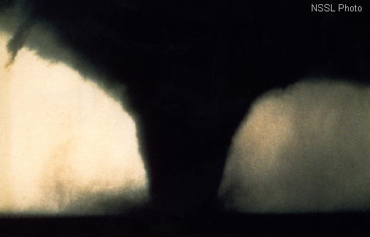
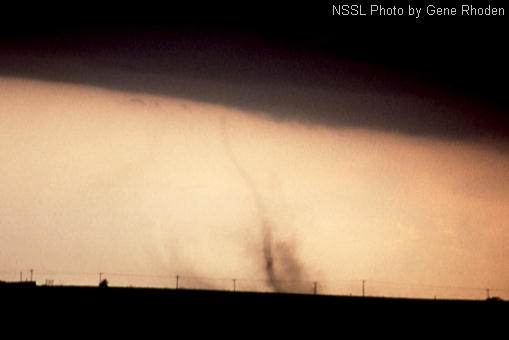
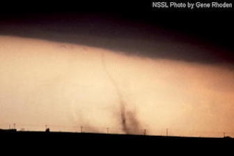
A tornado is a quickly rotating column of air, which reaches the ground. On the upper end of this column the tornado is connected to a cumulonimbus cloud. On rare occurrences, tornadoes can form beneath a cumulus cloud. A tornado can be prominently visible by the condensing air masses forming a cloud funnel beneath the parent cloud due to the extreme pressure drop. The funnel cloud doesn't necessarily has to have ground contact for the tornado to reach the surface. A debris cloud forming beneath the funnel cloud suggests that the tornado did in fact reach the surface and extreme wind gusts are prevalent at surface level.
Tornado without a condensed funnel cloud, note the debris cloud forming beneath the cloud, indicating that the tornado has ground contact
(F0 tornado Erick, Ok April 25, 1989), source:
NSSL (right)
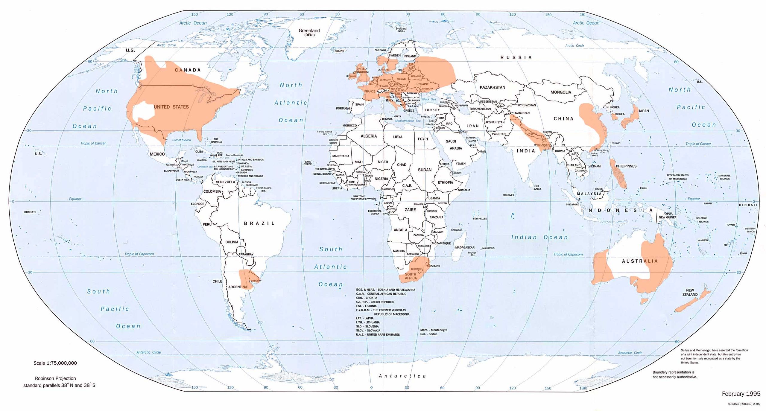
Global tornado occurrences (shaded), source:
NOAA (left)
|
 |
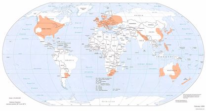 |
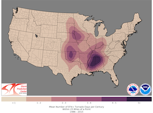
Tornadoes can occur globally in the mid-latitudes, where warm tropical to subtropical air masses meet much colder polar air masses. The most important region for tornado activity is the Great Plains in North America, east of the Rocky Mountains, with the most tornadoes being observed in the US, four times as many as in Europe. In Europe, the most tornadoes are reported in the Netherlands and the United Kingdom, with one of the highest tornado densities in the world due to the vivid weather conditions when cold fronts are passing, though most tornadoes are weak. The global maximum of tornado related deaths is in Bangladesh, mostly due to the poor construction quality and lack of precise warnings. Though, why is tornado activity so “common” in the Great Plains?
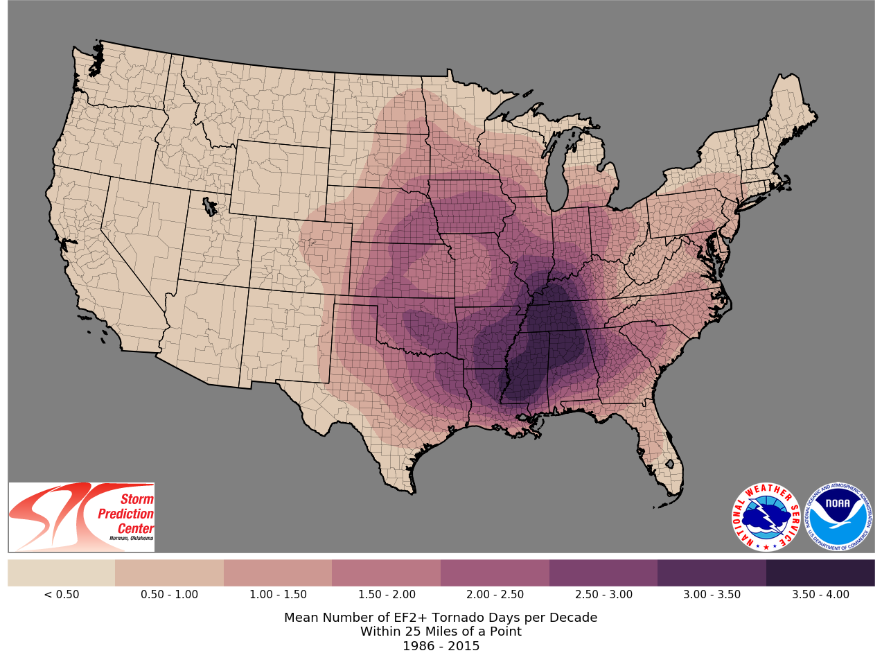
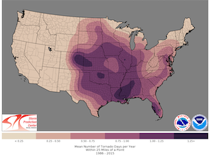
To answer this question, it is important to understand the synoptic ingredients needed for a tornado formation. Looking at a distribution of the tornado activity in the US, it is apparent, that most of the tornado activity in the US occurs in the southern part of the Great Plains, states like Oklahoma, Nebraska, and Colorado are one hotspot for tornado activity, as well as in the south of the US, states like Louisiana, Mississippi, and Alabama are a further hotspot for tornado activity. Florida is special case, as most tornadoes in this region tend to be rather weak and connected to the daily convective activity in the summer season in the humid tropical moisture or severe thunderstorm activity in tropical cyclones. Now, what makes the Great Plains so special, to explain this large number of observed tornadoes?
|
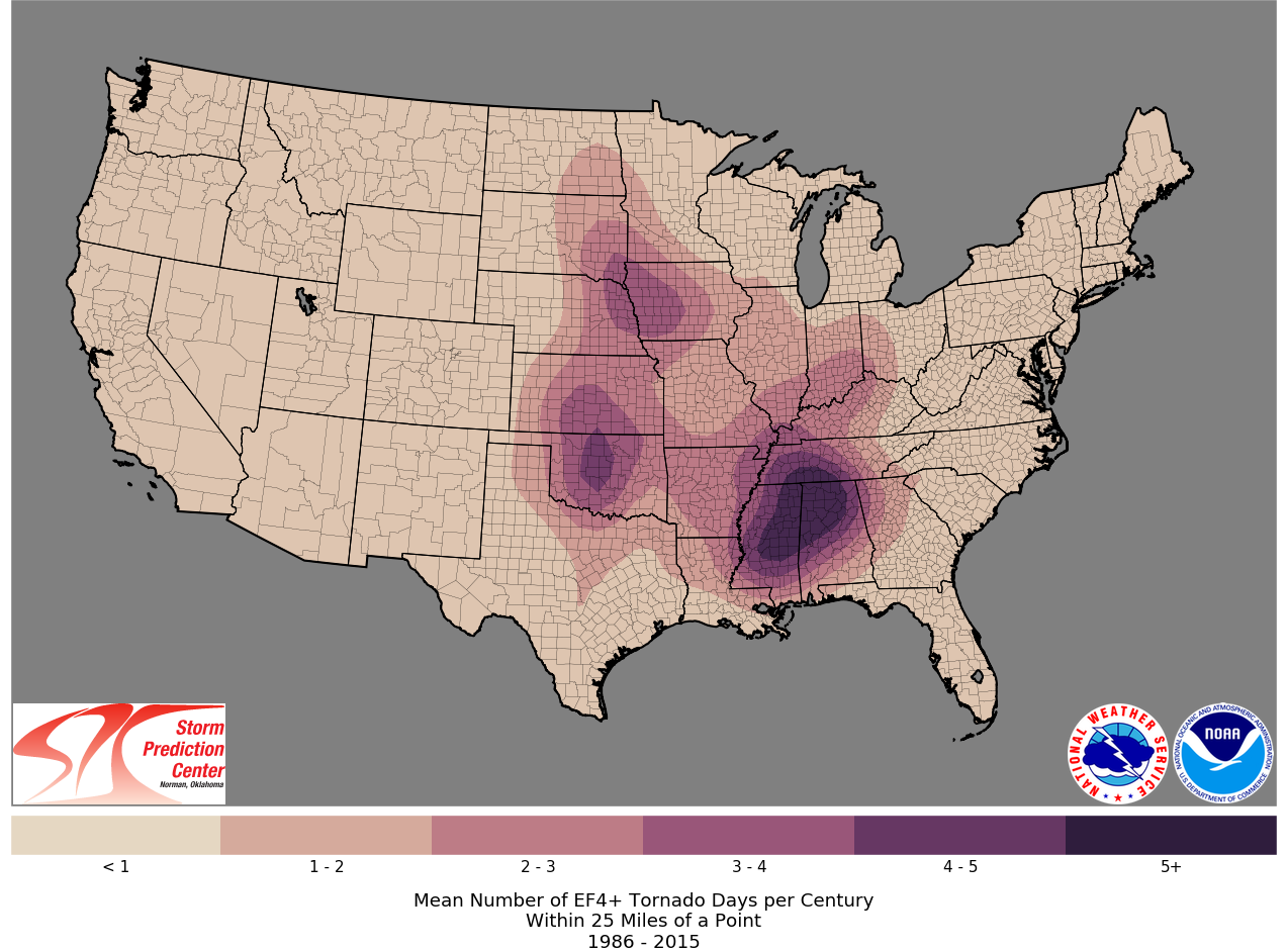
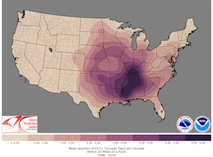
Tornado climatology in the US 1986 - 2015, all tornadoes (left), significant tornadoes (middle) and violent tornadoes (right), source:
SPC
|
 |
 |
 |
The topography of the American Continent plays a very important role, as the topography influences the general circulation pattern significantly. The Northern America Continent expands from the tropics to the high arctic with no latitudinal mountain range, like the Alps in Europe, separating the continent. On the one hand, this allows both warm and cold air masses to penetrate far north- or southwards respectively, creating intense temperature gradients. On the other hand, the Rocky Mountains lead to the formation of Lee waves, as the main westerly current must pass the mountain range, favoring the development of a trough structure east of the Rocky Mountains over the Great Plains. Most easily, this is explained with barotropic Rossby waves forming due to the conservation of absolute vorticity. Further, the mountain range blocks low-level moisture from passing, creating a distinct dry air mass, descending along the eastern slopes of the mountain range. In combination with the deserts in the Four Corners Region, a distinct dry line forms over the southern part of the Great Plains, where the dry air masses of the Rocky Mountains convergence with the very moist air masses originating from the Gulf of Mexico.
Dry line structure analyzed over the southern part of the Great Plains,
April 14, 2011, source:
NWS Little Rock
|
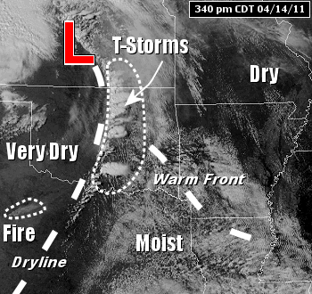 |
The dry line is typically found spanning from southern Texas into Oklahoma and Nebraska and can shift as far eastwards as the Mississippi Valley. Contrary to other meteorological fronts, the dry line doesn't necessarily have to have cyclonic shift of wind direction, therefore, not meeting the meteorological definition of a front. In the US, usually the 13 °C- dewpoint isotherm is used to identify the dry line in weather charts. The dry line shifts according to the diurnal cycle due to the solar insolation, eastwards during the daytime and westwards during the night. In the moist sector of the dry line convective activity is enhanced, especially right along the dry line, as the potential instability due to the increased moisture gradients favors convective activity in this region.
This creates the ingredients for severe thunderstorm activity. For a classic severe weather pattern, a trough east of the Rocky Mountains is required, leading to the advection of very cold air masses from the Canadian Arctic penetrating far to the south. Concurrently, the trough over the Great Plains leads to the northward advection of warm and moist air masses from the Gulf of Mexico. The descending air masses from the Rocky Mountains create a distinct dry instability in the lower atmosphere. Commonly, severe thunderstorm activity is initialized along the moist flank of the dry line, in the southeastern part of the Great Plains and moves northeastwards.
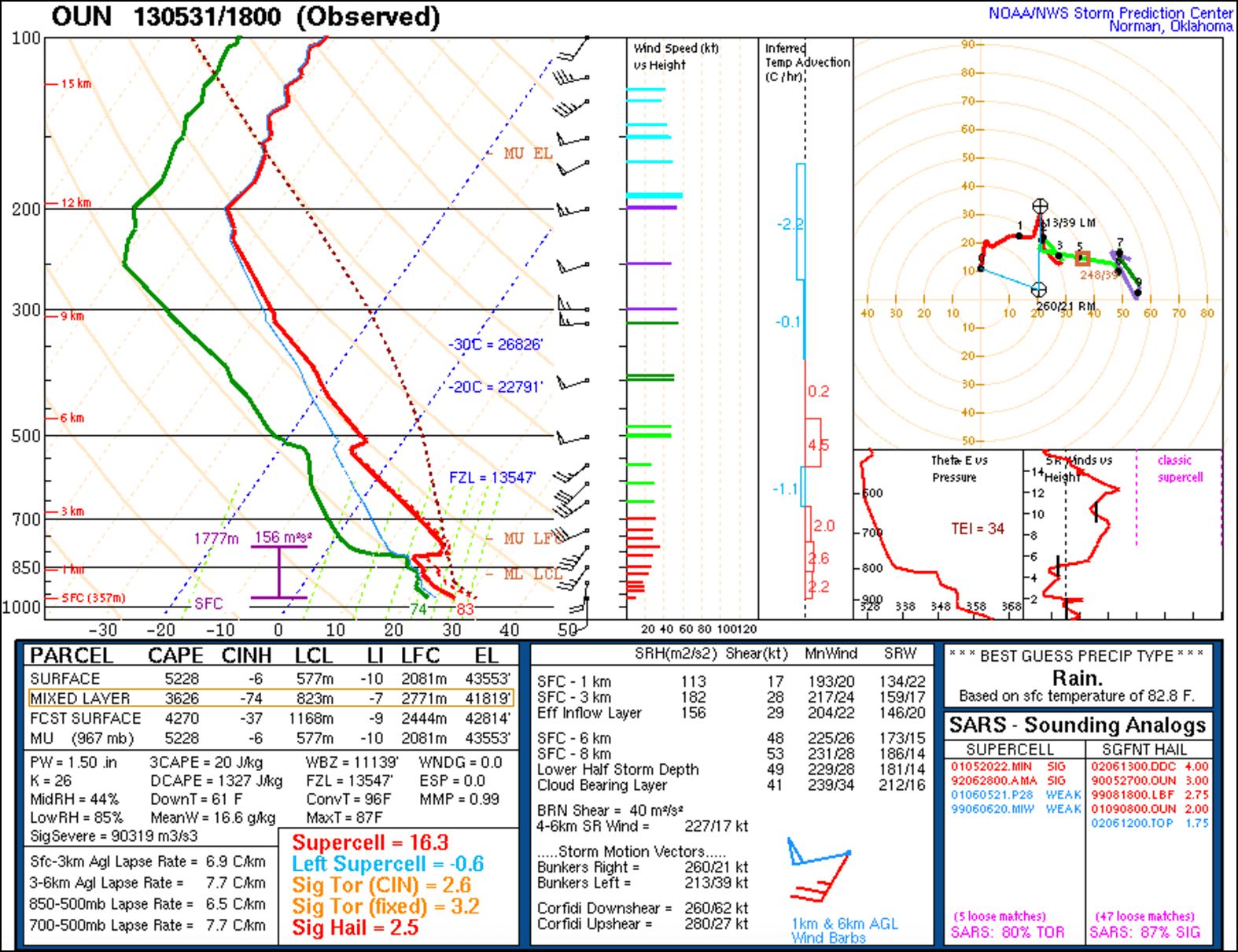
In an atmospheric sounding, such a weather pattern would lead to a high convective available potential energy (CAPE), as moist and warm air masses in the lower atmosphere lay beneath drier and colder air masses in the mid-atmosphere. Though, the high CAPE values aren't sufficient to explain the severe convective activity, as high CAPE values don't necessarily imply severe convective activity. A high convective inhibition (CIN) is needed to suppress widespread convective activity, as this leads to only very few thunderstorms breaking the CIN-barrier and developing and therefore draining a much larger reservoir of CAPE. This setup can be found in the moist sector of dry line, as commonly a strong capping inversion is found in this region, only weakening near the dry line.
|
Atmospheric soundings of Norman, OK on May 31, 2013 18 UTC before the infamous 2013 El Reno Tornado formed, source:
SPC
|
 |
The occurrence of a tornado is commonly proceeded by the formation of a supercell thunderstorm. To form a supercell both a vertical shear of the wind speed, as well as a vertical shear of the wind direction is needed. In the Great Plains, the wind commonly shifts from southwesterlies in the lower atmosphere to westerlies in the upper atmosphere, induced by the upper atmosphere polar jet. In an upper atmospheric sounding this vertical wind profile creates a hook shape structure in the hodograph. In the case of pure vertical wind speed shear, a bow line would develop. To estimate the strength of a potential supercell, it is important to know how much vorticity is transported into the supercell. The storm-relative environmental helicity (SREH) gives a measure therefore, when combining this with a threshold for CAPE the energy helicity index (EHI) can be defined, giving a measure for a potential supercell development. Supercells can be identified in the radar by their differing motion from the main mid-level atmospheric motion, as supercells can alter their movement direction. The movement of a supercell can be estimated in the hodograph by Bunker's Internal Dynamics method, giving the direction of motion of both the left and right moving supercell.
The violent updraft of a supercell erects the horizontally rotating column feeding vorticity into the storm vertically, giving the supercell its signature cloud rotation. At the bottom of the main vertical rotating column, a distinct cloud base develops, the wall cloud sometimes referred to as mothership. It remains unsure which mechanisms confine the vorticity of the rotating column of the supercell in the wall cloud to form a tornado. Only a small percentage of all supercells do in fact form a tornado (< 30 %). Especially in winter, low topped supercells forming in the cold sector of strong winter storms tend to be common when a polar air mass and strong jet stream are present over Europe, though only forming rarely a tornado.
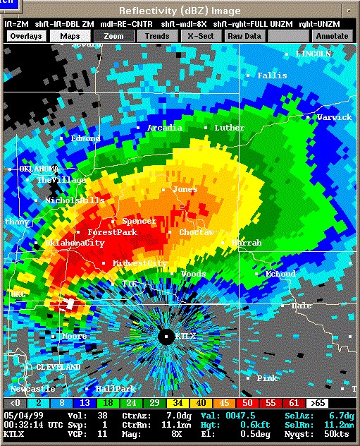
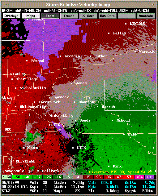
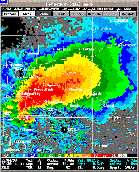
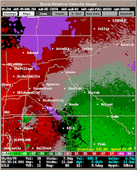
A precipitation radar can give a distinct signal of a tornado. The hook echo forming at the southwestern side of the supercell shows the presence of a tornado, the tornado is situated in the broader area at tip of the hook facing towards the supercell, showing the mesoscale rotation of the thunderstorm. Further, tornadoes can be identified with a Doppler radar, using the Doppler shift to determine the motion of the atmosphere. The rotation of the tornado is prominently visible by the shift from quickly nearing and departing signals in the output of the Doppler radar. Often the rotation forms two semicircles with distinct wind anomalies.
|
Radar image (left) and Doppler radar image (right) of the 1999 Bridge Creek Tornado May 04, 1999 00:32 UTC, source:
NWS Norman
|
 |
 |
For an observer on the ground, the visibility of a tornado is dependent on the position relative to the storm and precipitation mode of the supercell. The most prominent tornadoes develop from low precipitation supercells, an example therefore is the 2007 Elie, Manitoba Tornado. In high precipitation supercells the view of the tornado is obstructed by the rain and hail core of the system. These tornadoes are often referred to as rain-wrapped tornadoes, an example therefore is the infamous 2013 El Reno Tornado. These tornadoes can be particularly dangerous as the funnel of the tornado isn't visible with the naked eye and can only be identified with radar analysis. Around the main funnel of the tornado, sub-vortices can develop, rotating around the said funnel. The direction of rotation is dominantly anti-clockwise in the Northern Hemisphere and clockwise in the Southern Hemisphere. Though, clockwise rotating tornadoes have been observed. A single supercell can spawn multiple tornadoes during its life cycle, like the 2014 Pilger Tornado Family. An underestimated danger of a tornado can be the erratic movement of the twister. The tornado mostly follows the motion of the storm but can make sudden kinks or loop in its track. Also, tornado skipping can be observed, if the main rotation breaks down into multiple sub-vortices, making it extremely difficult to predict the precise track of the tornado. For an observer, the strong winds in a severe thunderstorm can be mistaken for a tornado, most commonly downbursts of cold air masses in the thunderstorm, especially violent in microbursts.
Tornado scales
The strength of a tornado is quantified by the Fujita scale, introduced by Ted Fujita in 1971, building a bridge between the Beaufort Scale and Mach scale (for speeds above the sound barrier). F1 starts roughly from the hurricane-force threshold of Bft 12 and F12 begins at the speed of sound.
| Scale |
Wind speed in kph |
Damage |
F0
F1
F2
F3
F4
F5
|
64 - 116
117 - 180
181 - 253
254 - 332
333 - 418
419 - 512
|
light damage
moderate damage
significant damage
severe damage
devasting damage
incredible damage
|
|
Never has an F6 tornado been observed, though two tornados had a preliminary F6 rating in the 1970s, today only the aforementioned 1999 Bridge Creek Tornado could have potentially surpassed the F6-threshold, though no near surface measurements have ever recorded such wind speeds. Yet, no wind speeds above 500 kph are necessary to cause devasting damages. For humans, neither the incredible wind speeds nor the violent pressure drop is the most dangerous features of a tornado, however it is debris transported by the tornado which causes the most injuries. Damage severity along the path of the tornado can change erratically in close distance, as for example the motion of the parent system reduces the wind speed on side of the tornado and on the side on which the direction of motion is aligned with tornado rotation it increases the wind speeds.
In 2007, the National Weather Service introduced the Enhanced Fujita scale which incorporates the visible damage of a tornado, to better categorize the tornado's strength. Therefore, the wind speed threshold tweaked slightly, further the Enhanced Fujita scale, ends with category EF5, needing no more discussion if a F6 tornado occurred.
| Scale |
Wind speed in kph |
Damage |
EF0
EF1
EF2
EF3
EF4
EF5
|
105 - 137
138 - 177
178 - 217
218 - 266
267 - 322
> 323
|
light damage
moderate damage
significant damage
severe damage
devasting damage
incredible damage
|
|
To shelter from a tornado, it is best to take cover in the basement of a building. If the building has no basement, one should shelter in the room with the most walls between you and the outside walls or beneath a solid structure of the building such as a staircase. Especially in times before the spread of the mobile phone, many people in the sparsely populated regions of the Great Plains took portable radios with them, as tornado and severe weather warnings are broadcasted by radio. Further, many towns in the Great Plains have tornado sirens warning of a nearing tornado.
In a year, tornado activity varies significantly. In the winter months tornado activity is reduced, with the center of activity in the deep south of the US. Tornado outbreaks in this region tend to be most deadly, as these regions are one of the poorest of the US, with many people living in mobile homes, most of the time build from lighter materials than build-in-place homes. In spring, the highest tornado activity is observed (maximum in May), with the area of most common tornadoes shifting to the northwest into the Oklahoma, Nebraska region, with many F5 tornadoes being observed in this region. In this time, the temperature gradients between polar and tropical air masses are most prominent, creating the most favorable environment for severe thunderstorm activity. In summer, the number of tornadoes decreases and shifts to the Northern Plains, as the subtropical ridge shifts into the Southern Plains and the temperature gradients between the tropical and polar air masses decreases. In autumn, a second spike of tornado activity is observed, with a second peak observed in September, when the temperature gradients over the Great Plains are once again increasing and overall temperatures are high enough to provide sufficient energy for severe thunderstorm activity. Often a high number of tornadoes occur during tornado outbreaks, where the synoptic situation is especially favorable for tornado activity. Most renown are the super outbreaks of April 1974 and April 2011.
Tornado records
| Record |
Value |
|
Average US tornadoes
Most active US tornado season
Most tornadoes in a single month in the US
Most tornadoes in a 24 h-span
Most EF5/F5 tornadoes in a 24 h-span
Highest wind speed in a tornado
Widest tornado
Longest track
Fastest forward speed
Longest duration
Deadliest Tornado
Costliest Tornado
Longest survived carriage by a tornado
Longest EF5/F5 drought
|
1200 tornadoes
1817 tornadoes
773 tornadoes
216 tornadoes
7 F5 tornadoes
484 kph
4.2 km
352 km
117 kph
3.5 h
1300
3373 million USD
398 m
since May 20, 2013
|
2004
April 2011
April 27 - April 28, 2011, 05 UTC
April 3 - April 4, 1974
1999 Bridge Creek Tornado
2013 El Reno Tornado
1925 Tri-State Tornado (potentially tornado family)
1925 Tri-State Tornado
1925 Tri-State Tornado
April 26, 1989, Bangladesh
2011 Joplin Tornado (adjusted for 2021 USD)
March 12, 2006, Fordland, MO
last EF5 tornado: 2013 Moore Tornado
|
|
Tornadoes in Germany
Tornadoes do occur in Germany, though there much more uncommon than in the US. They can occur during the winter season, when along the cold fronts of pronounced extratropical lows give favorable environments for tornado formation. In summer, severe thunderstorms can form tornadoes, though most of them tend to be rather weak. The 1968 Pforzheimer Tornado is most likely the most intense tornado of the last century in Germany, ranking as a F4 tornado.
Text: KG
April 06, 2023
|