Banner
Der Internet Explorer bietet nur eine eingeschränkte Funktionalität. The browser you're using is only limited functionable.

Thursday, 12 January 2023, 18:00 UTC


500 hPa Geopotential and surface pressure over
Northern America, 15.01, 00 UTC
Source: Wetter3
7-day accumulated precipitation over the US,
19.01 12 UTC
Source: WPC
14 d precipitation anomaly over the western part of the US,
12.01
Source: Water.weather
Expected river stages of the
Sacramento River at Colusa Brigde, CA,
12.01 17 UTC
Source: CNRFC


Heavy rain and snow
California, USA

Issued: Thursday, 12 January 2023, 18:00 UTC

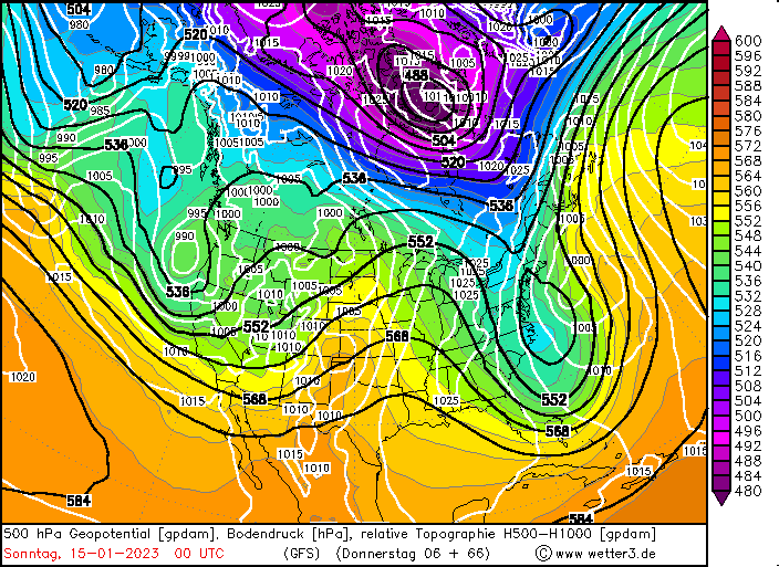
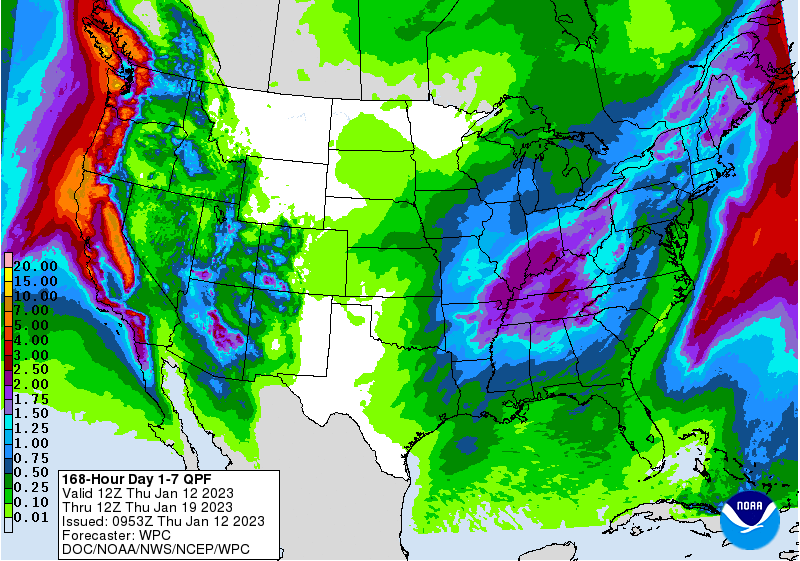
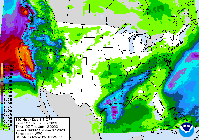
A very wet weather pattern is persistent over the western part of the US, bringing excessive precipitation to the state of California. Another round of storm activity is expected over the weekend lasting until Wednesday, January 18, with precipitation totals up to 250 mm in the Sierra Nevada.

12.01.2023


Since the Christmas Days a persistent trough structure over the Eastern Pacific is dominating the weather across the western part of the US, with strong extratropical lows bringing excessive precipitation to the state of California. Along western facing flanks, precipitation totals reached more than 1000 mm, with multiple meters of fresh snow accumulation at higher altitude, especially along the Sierra Nevada.
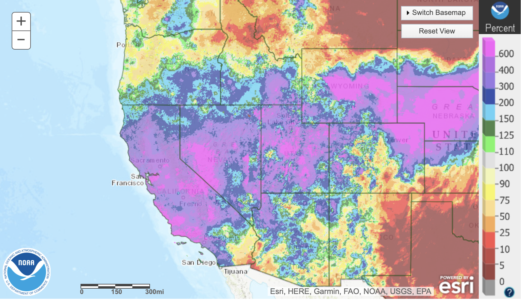
On Friday, January 13, another storm system is expected to impact the West Coast of the US, bringing again excessive precipitation to the state of California with precipitation totals over 250 mm along western facing flanks of the Sierra Nevada and parts of Northern California. With a second system on Sunday, January 15, up to 100 mm of rain are expected in the Central Valley, the precipitation is expected to reanimate flooding activity in the Central Valley as the soils in large parts of California are already saturated. At higher elevations, mainly in the Sierra Nevada, excessive snow fall is expected with multiple meters of fresh snow accumulation, leading to severe travel disruptions along the Sierra Nevada due to fresh snow accumulations and at lower elevations due to river flooding.
In the coming week the storm activity over California is expected to die down, nevertheless the recent period of enhanced precipitation activity relieved brought concerns in California, as well as building a substantial snowpack in the Sierra Nevada, with snow-water equivalent already surpassing the season average in large parts of the Sierra Nevada.


Saturday, 7 January 2023, 12:00 UTC


500 hPa Geopotential and surface pressure over
Northern America, 09.01, 12 UTC
Source: Wetter3
24 h precipitation over the US, 10.01. 12 UTC
Source: WPC
24 h precipitation return-periods over the US,
10.01 12 UTC
Source: WPC
5-day accumulated precipitation over the US,
12.01 12 UTC
Source: WPC


Heavy rain and snow
California, USA

Issued: Saturday, 7 January 2023, 12:00 UTC

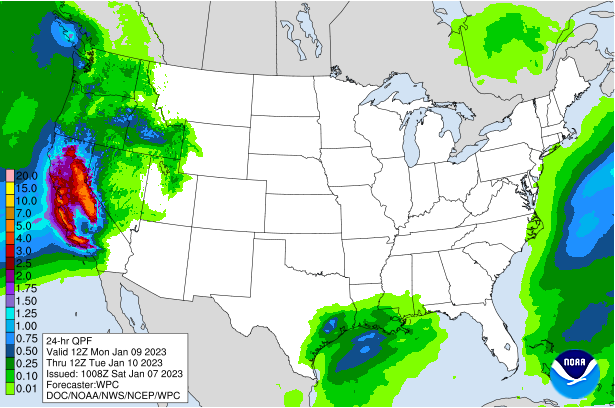
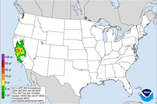
A very wet weather pattern over California continues over the weekend with another round of powerful storms hitting the state, bringing intense precipitation and high winds. At higher altitudes substantial snow fall is expected. Up until Wednesday, January 11, over 250 mm of precipitation are expected in the Sierra Nevada.

07.01.2023


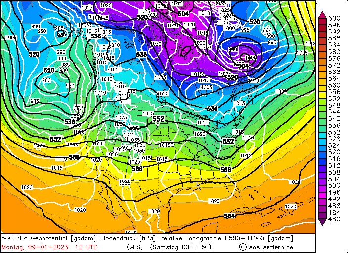
A strong trough over the Eastern Pacific is persistent since the Christmas Days, bringing a series of extratropical storms into California. The past systems have already brought intense precipitation to the state, upwards of 500 mm since December 26, 2022, along the western flanks of the Sierra Nevada. Leading to fresh snow accumulations of up to 300 cm at Mammoth Mountain, CA. In the Central Valley, in cities like Sacramento, CA received up to 160 mm of rain since Christmas, relieving the drought concerns in California.
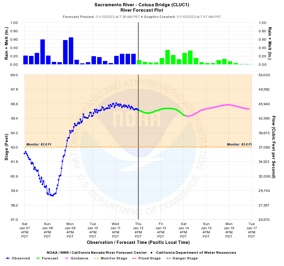
In the coming hours a first system will hit California bringing intense precipitation to the state. At altitudes above 2000 m, especially along the western facing flanks of the Sierra Nevada, heavy snow is expected. With up to 100 mm/24 h of precipitation in Northern California and up to 50 mm/24 h in the Central Valley.

On Monday, January 9, a more intense storm system is expected to reach California. Wind gusts in the Central Valley are expected to reach 100 km/h, with gusts upwards of 160 km/h along the Sierra crests. With the system, intense precipitation is expected, in the Central Valley up to 100 mm/24 h are forecasted and in the Sierra Nevada as well as the Coastal Ranges of California up to 150 mm/24 h of precipitation must be expected. In parts of the Central Valley, 24 h-precipitation rates with return-periods of up to 25 years must be expected, with extreme ensemble members suggesting precipitation amounts with return-periods of up to 100 years. 5-day storm totals of over 250 mm in the Sierra Nevada are expected, leading multiple meters of fresh snow accumulation in the higher elevations in the Sierra Nevada.
Severe travel disruptions must be expected, both by extreme snow fall at higher altitudes as well as flooding in lower elevations. As many rivers in the Central Valley are already reporting flooding, with water levels expected to rise significantly with storm systems passing California.


Wednesday, 4 January 2023, 11:00 UTC


500 hPa Geopotential and surface pressure over
Northern America, 05.01, 00 UTC
Source: Wetter3
RGB satellite imagery over the
Eastern Pacific, 04.01 10:26 UTC
Source: NOAA
24 h precipitation over the US until 04.01. 12 UTC
Source: WPC
24 h precipitation return-periods US
until 04.01 12 UTC
Source: WPC


Heavy rain and snow
California, USA

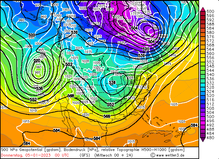
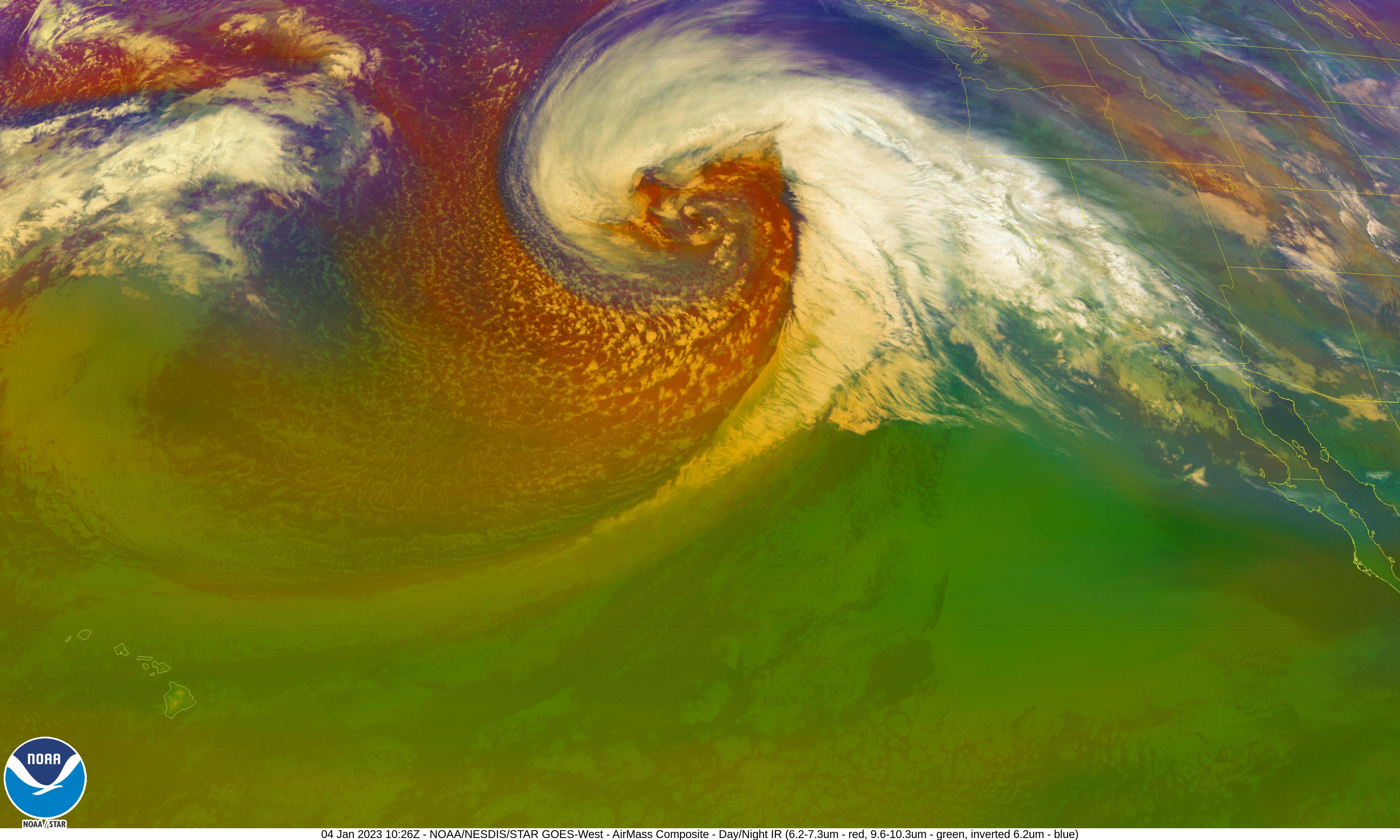
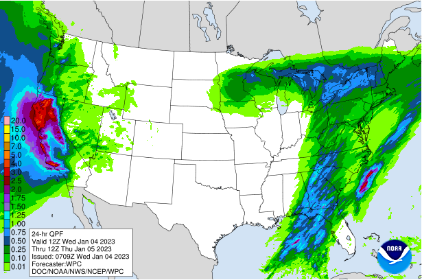
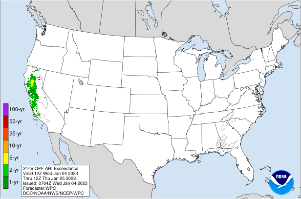
Issued: Wednesday, 4 January 2023, 11:00 UTC

Another powerful storm is expected to hit California later today, accompanied by excessive precipitation upwards of 75 mm/24 h in the valley regions and more than 100 mm/24 h in the mountains. Accompanied by powerful winds with gusts up to 100 km/h in the Central Valley. At higher elevations significant snow accumulations up to 1 m are possible. Small stream flooding is likely.

04.01.2023


After a very wet December in California, locally the wettest December on record, a potent atmospheric river brought intense precipitation to California on New Year's Eve, with storm totals exceeding 300 mm in the Sierra Nevada. While San Francisco, CA recorded the second wettest day on record on New Year's Eve with a daily precipitation of 138.7 mm at the station San Francisco Downtown, just shy of the all-time record.

In the night from today, January 4 to tomorrow, January 5, a strong extratropical low over the Eastern Pacific is expected to move eastwards towards the west coast of the US. Inducing heavy precipitation primarily in Northern and Central California. With large parts of the Central Valley expecting more than 50 mm/24 h, locally up to 100 mm/24 h, giving an average return-period of 2 years. Along westwards facing slopes, widespread precipitation of over 100 mm/24 h are likely, possibly reaching more than 150 mm/24 h. Above 1500 m heavy snow is expected with up to 1 m of fresh snow accumulation at higher elevations.


In the Sierra Nevada massive travel disruptions must be expected due to the intense snow fall. While at lower altitudes, river flooding is a growing concern as the soils of the Central Valley are getting saturated. Thursday and Friday a short improvement of weather conditions is expected, with another round of intense precipitation forecasted over the weekend in California.


Friday, 30 December 2022, 13:00 UTC


500 hPa Geopotential over Northern America,
31.12, 00 UTC
Source: Wetterzentrale
850 hPa Pseudopotential temperatures over
Northern America, 31.12 00 UTC
Source: Wetter3
Accumulated Precipitation over the
Southwestern US until 01.01.2023 00 UTC
Source: SPC
24 h fresh snow accumulation over the
Southwestern US, 01.01.2023 00 UTC
Source: SPC


Heavy rain and snow
California, USA

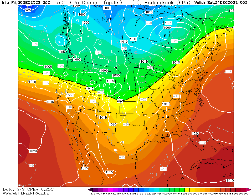
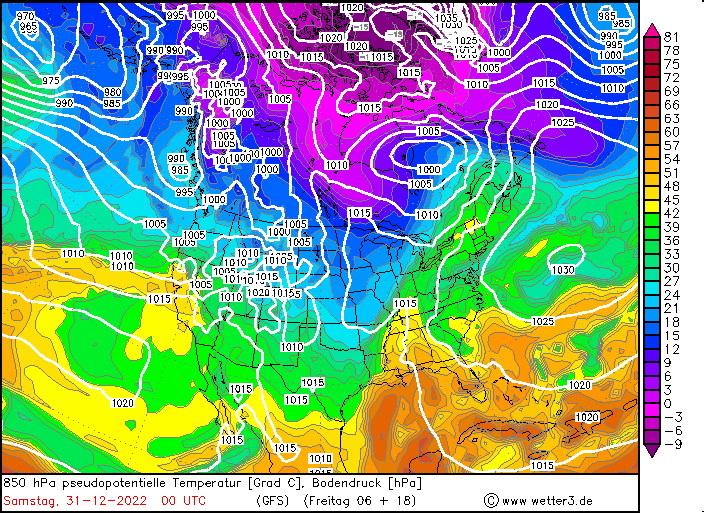
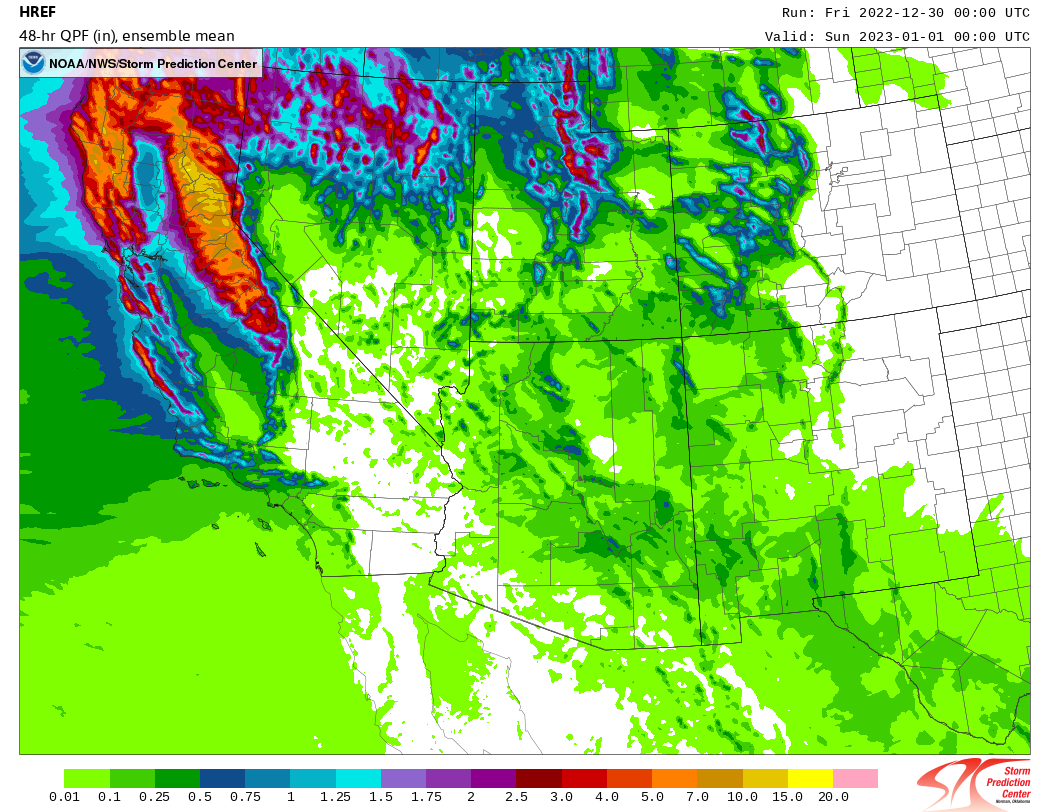
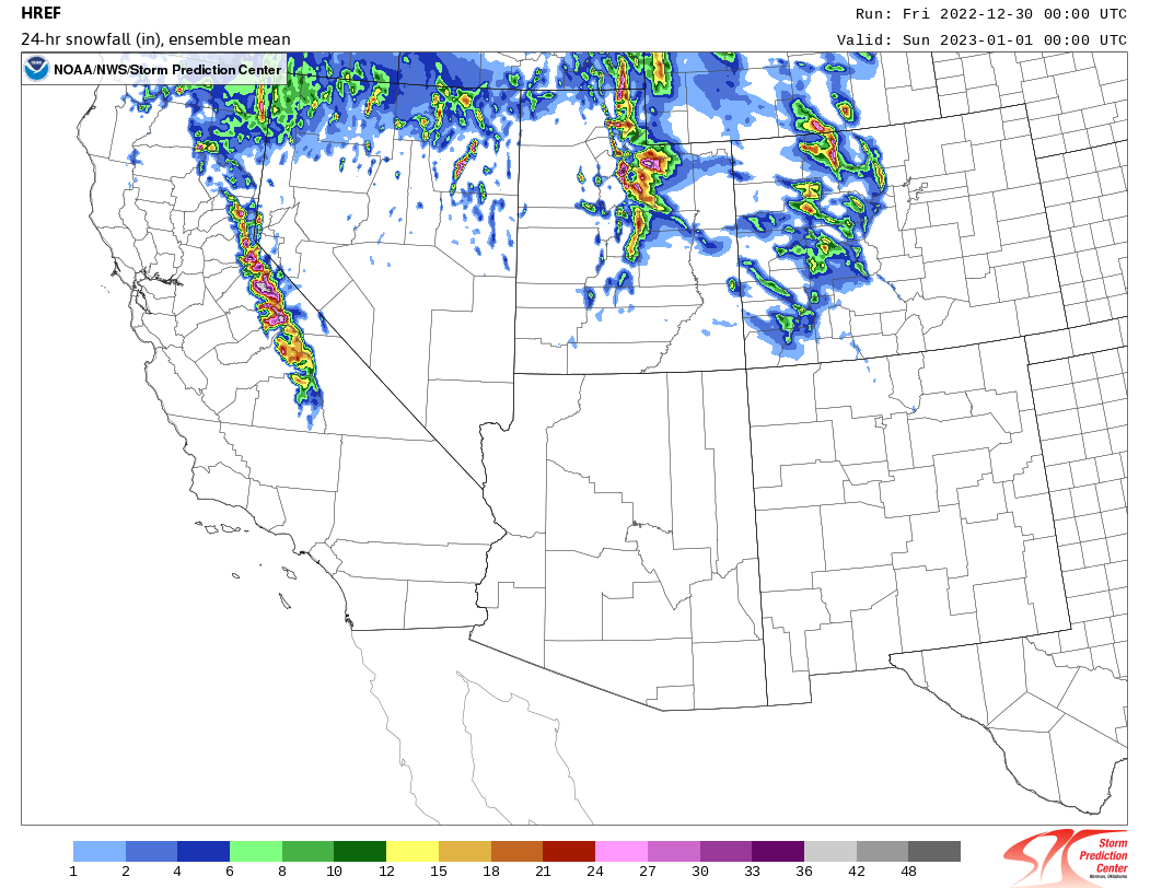
Issued: Friday, 30 December 2022, 13:00 UTC

A very wet weather pattern is expected to set in over the western part of the US. With a zonally aligned flow over the Eastern Pacific air masses of tropical origin get advected into California, leading to abundant precipitation as well as extreme snowfall in the Sierra Nevada.

30.12.2022


With a strong zonally aligned flow, a very wet weather pattern is expected in the coming days in California. The combination of a trough over the Northern US and Southern Canada and a ridge over the southwestern part of the US and northern Mexico will lead to the advection of moist air masses into California. When the westerly flow reaches the Sierra Nevada strong orographic lift is induced, leading to a sharp increase in precipitation. Further, these systems are expected to bring high winds into California, especially along the ridge crest of the coastal mountain ranges and the Sierra Nevada.

The western part of the US already experienced a snowy start to the winter season 2022/23, with the snow water equivalent running at 150 % of the season average up to date. On December 27 a first storm system moved through California, leaving up to 100 mm of precipitation on the western flank of the Sierra Nevada with wind gusts up to 160 km/h on the mountain tops. Today, December 30 and December 31 an intense system is expected to move through California, inducing heavy precipitation. Within a 48 h-period on the western flanks of the Sierra Nevada precipitation amounts of over 250 mm are possible, at higher elevations extreme snow accumulations are expected. Severely increasing the avalanche risk in the Sierra Nevada as well as massively impeding travel across the Sierra Nevada, especially along I-80. In the Central Valley up to 100 mm of rain can be expected.


In the new year a short spell of drier weather conditions is expected with abundant precipitation following. In the coming days flooding in California can be an issue, larger river flooding is dependent on the exact precipitation amounts as well as the snow line in the Sierra Nevada. Within the coming two weeks in the Sierra Nevada ensemble means show accumulated precipitation amounts of up 400 mm, with extreme model runs showing the potential for over 600 mm of precipitation. While the Northern Central Valley is expected to receive up to 200 mm of precipitation, relieving drought concerns in California. Further inland significant snowfall can also be expected as moist air masses move over the Sierra Nevada.


Issued: December 30, 2022, 13:00 UTC
KG

Issued: January 4, 2023, 11:00 UTC
KG

Issued: January 7, 2023, 12:00 UTC
KG

Issued: January 12, 2023, 18:00 UTC
KG


Visit us at
Facebook:

Information on warning levels and icons used
Information on meteoalarm.eu