|
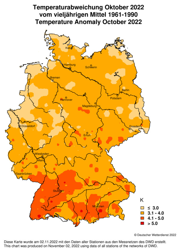
October 2022 marked the warmest October on record for Germany with a temperature surplus of 3-5 K from nothern to southern Germany. On October 28 a maximum temperature of 28.7 °C was recorded in Müllheim (BW).
The summer of 2022 in Central Europe brought almost uninterrupted temperatures above 30°C, numerous hours of sunshine and hardly any days with poor weather.
The summer months (June, July, August) 2022 were the warmest in Central Europe since the beginning of weather observations. At the weather station in Mannheim,
the 30°C mark was exceeded 46 times, the 25°C mark even 75 times. Only on 17 days, the temperature did not reach the required threshold for a summer day.
Not surprisingly, all three summer months were 1.5 to 3.5°C above the climatological average (compared to 1981-2010).
|
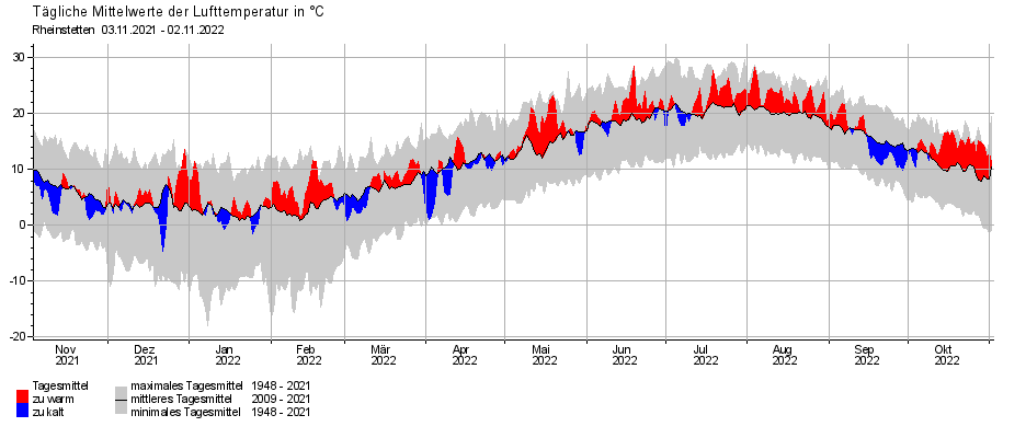
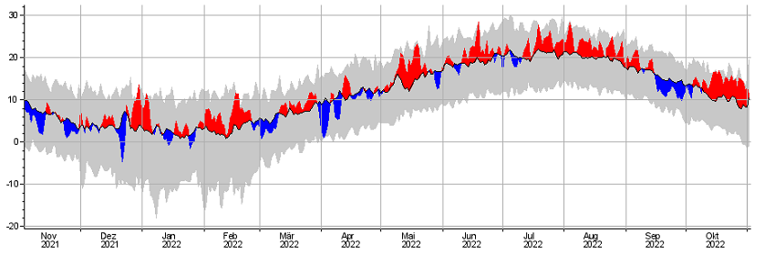
2m temperature time series and anomaly for Rheinstetten, source:
DWD
|
 |
In September, conditions reversed, at least for some parts of Germany. Several low-pressure areas such as QUEENIE or REILI caused polar air masses to be
directed to Germany. The result were lower temperatures and lots of convective precipitation. Especially in central and southern Germany, however, there were
not only repeated showers - here, heavy and continuous rain ensured that the precipitation balance of the year 2022 was polished up considerably. The distribution
of precipitation was quite uneven , with the south and west reaching 200% or more of the usual September amount. The northeast of Germany, on the other hand,
continued to experience a drought situation. At the weather station in Mannheim, a new record high (145.9 mm) of total precipitation was set in September.
For comparison: In the summer months of June, July and August, only 95.3 mm accumulated precipitation was recorded.
|
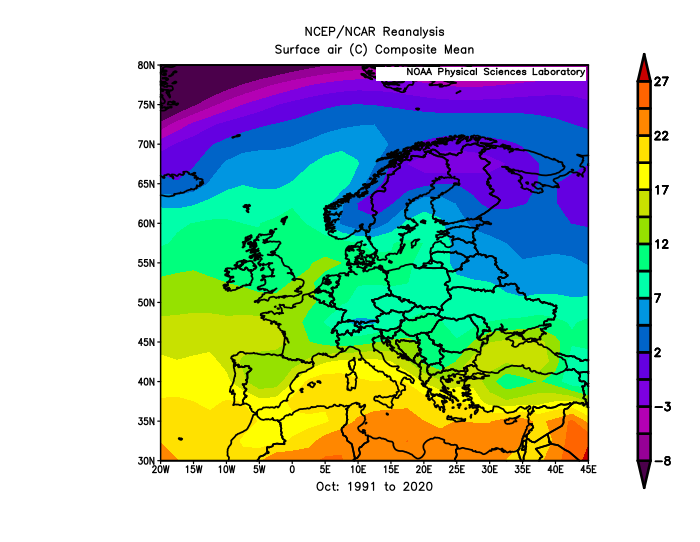
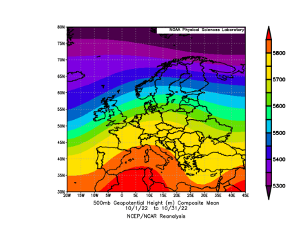
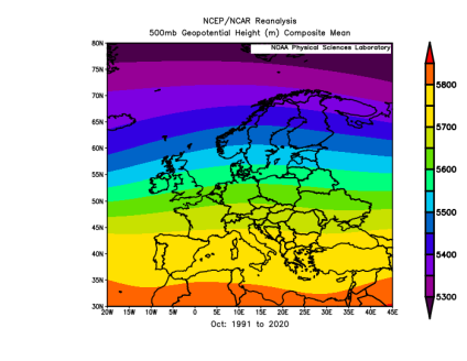
500 hPa Geopotential for Oct 2022 and Oct 1991-2020, source:
NOAA
|
 |
 |
October then continued where the summer months of June, July and August had left off. In Germany, October 2022 was the warmest October since the observations
of weather began. The climatological mean of the 500 HPa geopotential clearly shows a pronounced ridge over Central Europe, which not only provides for large-scale
negative vertical motion (subsidence), but also enables the inflow of mild air from the southwest at the back side.
The last weekend of October saw numerous new record highs. For example, a maximum temperature of 28.7 °C (Müllheim) occurred in southwestern
Baden-Württemberg on October 28. A total of 33 stations recorded a summer day (T > 25 °C). In Dachsberg-Wolpadingen and Zinnwald-Georgenfeld (both at about 880 m
above sea level) even new monthly records were set. 22.2 and 21.8 °C were registered here - on October 28. On the following Saturday, the 25 °C mark was again
exceeded in many places. In Geretsried, Bavaria, the mercury climbed to 27.0 °C, and 26.2 °C was also reached in Baden-Württemberg (Elzach-Fisnacht).
As is so often the case in autumn and winter, unusual warmth is caused by a southwesterly inflow. In the last weeks of October, mild air from the Mediterranean
region and the Iberian Peninsula was directed to Germany along the border between the high pressure area "Zacharias" and the low pressure areas "Iris" and "Jenny".
A little Sahara dust was also present, as could be felt in the slightly dimmed sunlight. What contributes significantly to the achievement of these high records
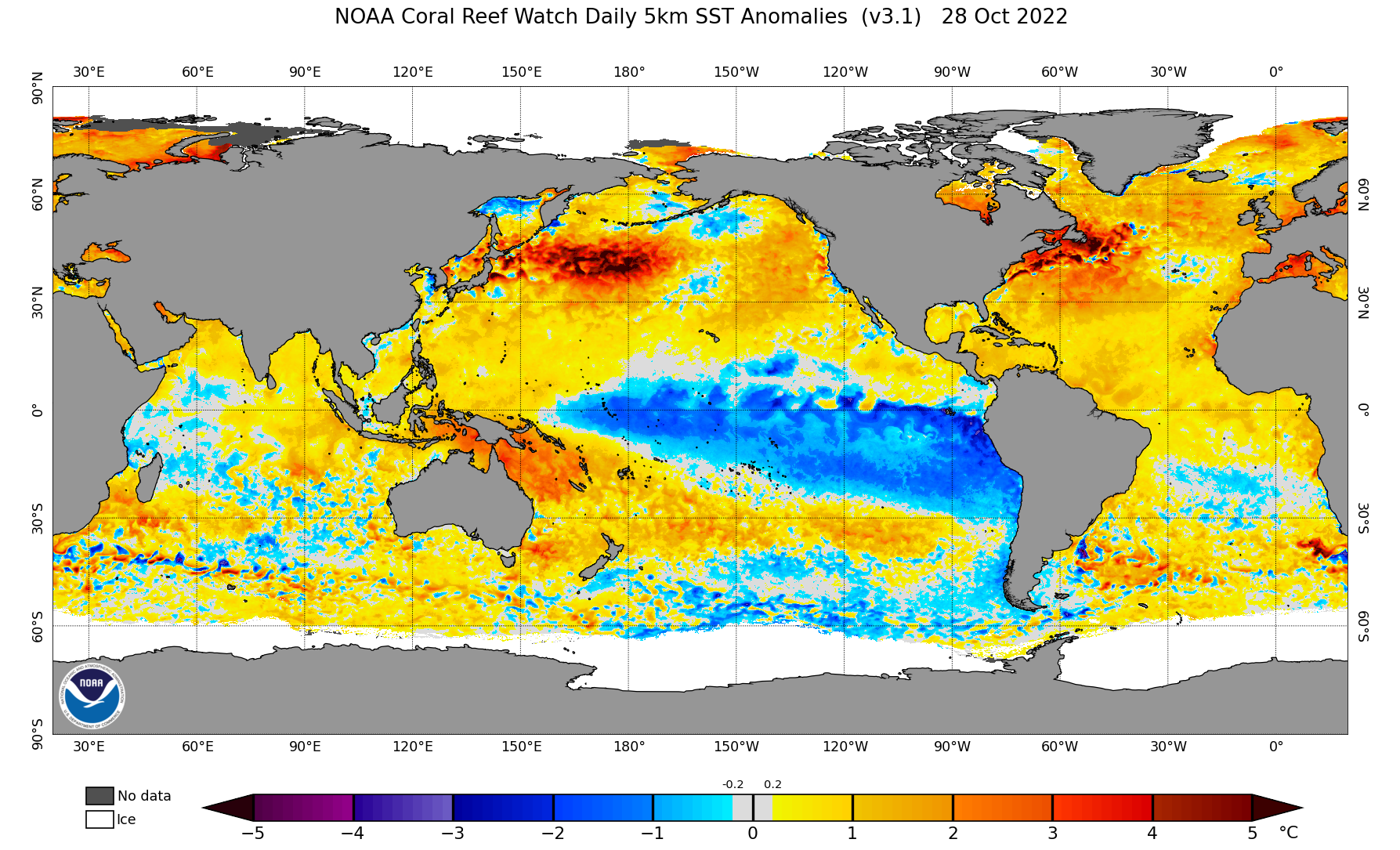
is also the history of the previous summer. Due to persistent heat, the oceans are still heavily overheated. The entire North Atlantic shows above-average temperatures,
and in the western Mediterranean the temperature is even up to 5 °C above average. This is of course noticeable when air masses from these regions are directed to Germany.
|
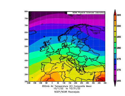
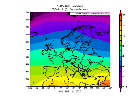
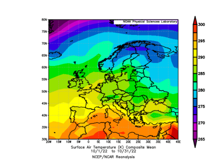
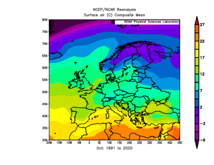
850 hPa Temperature (upper row) and 2m temperature (lower row) for Oct 2022 and Oct 1991-2020, source:
NOAA
|
 |
 |
 |
 |
Also in the 850 hPa temperature and in the 2m temperature at ground a clear positive deviation from the climatological mean for the entire Central and Western Europe is evident.
It is remarkable that especially the Mediterranean region shows only a small positive deviation with respect to the 850 hPa temperature, but deviates considerably from the
climatological mean at the ground level, which is due to the increased water temperatures. In Eastern Europe, the temperature anomaly was less pronounced; here, the pronounced
ridge over Central Europe meant that rather cold air masses of polar origin or air masses from Scandinavia were able to penetrate into Eastern Europe.
|
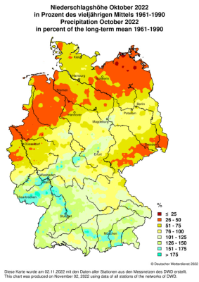
Anomalies in 2m temperature, sunshine duration and precipitation for Oct 2022, source:
DWD
|
 |
 |
 |
Within Germany, the temperature anomaly was strongest in the south and southwest. Locally, there was a difference of 5 K, whereas in the northwest the difference was only around 3 K.
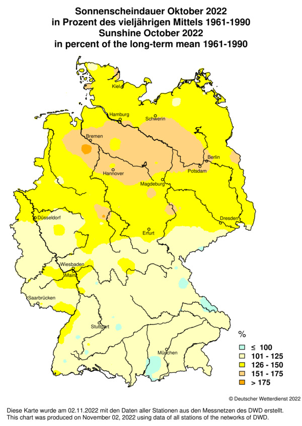
A contrasting picture emerges with regard to sunshine duration. Basically, the sunshine duration is above average in almost all parts of Germany, but the surplus is lowest in the south
with 1 - 25 %. In the northern half, the surplus was 26 - 50 % in many places, and in parts of Lower Saxony, Mecklenburg-Western Pomerania and Brandenburg it was as high as 51 - 75 %.
It was pretty much in these regions where dramatically low precipitation amounts fell in October. In many places, less than 25% of the usual amount came together. The same applies to
the region around the Ore Mountains. In the rest of central Germany and in the south of the country, precipitation was approximately on average, locally there were even precipitation
excesses of 51 - 75 %.
Text: FS
November 04, 2022
|