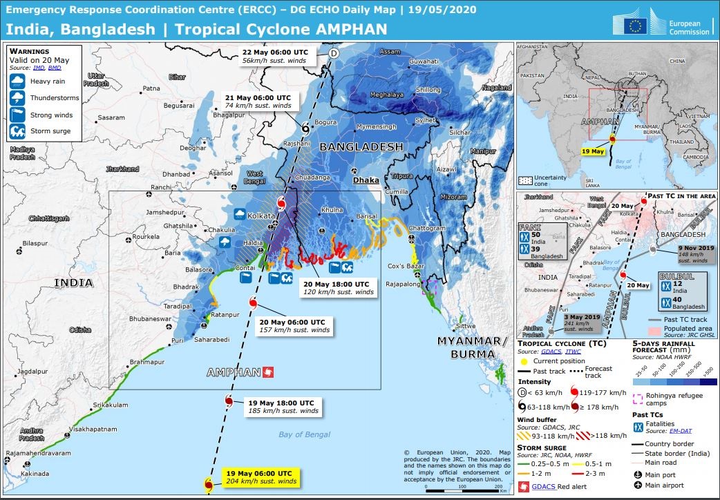
|
Super Cyclonic Storm AMPHAN reached 1-minute sustained winds of up to 260 kph and became the strongest tropical cyclone in
the North Indian Ocean on record (tied with GONU 2007). It made landfall in the western part of the Ganges Delta and led
to severe storm damage and flooding in West Bengal and low-lying parts of Bangladesh. Precipitation up to 261 mm/24h.
The development of Super Cyclonic Storm AMPHAN started on 13 May when an area of low pressure developed in the southeast of the
Bay of Bengal. An almost ideal distance to the equator, sea surface temperatures of more than 30°C and low vertical wind shear
provided a favourable environment. The India Meterological Department classified the system, which was still located in the south
of the Bay of Bengal, as a Tropical Depression on 16 May. In the further course, bands of deep convection formed near the circulation
centre. The system was then upgraded to a Cyclonic Storm and named AMPHAN.
|
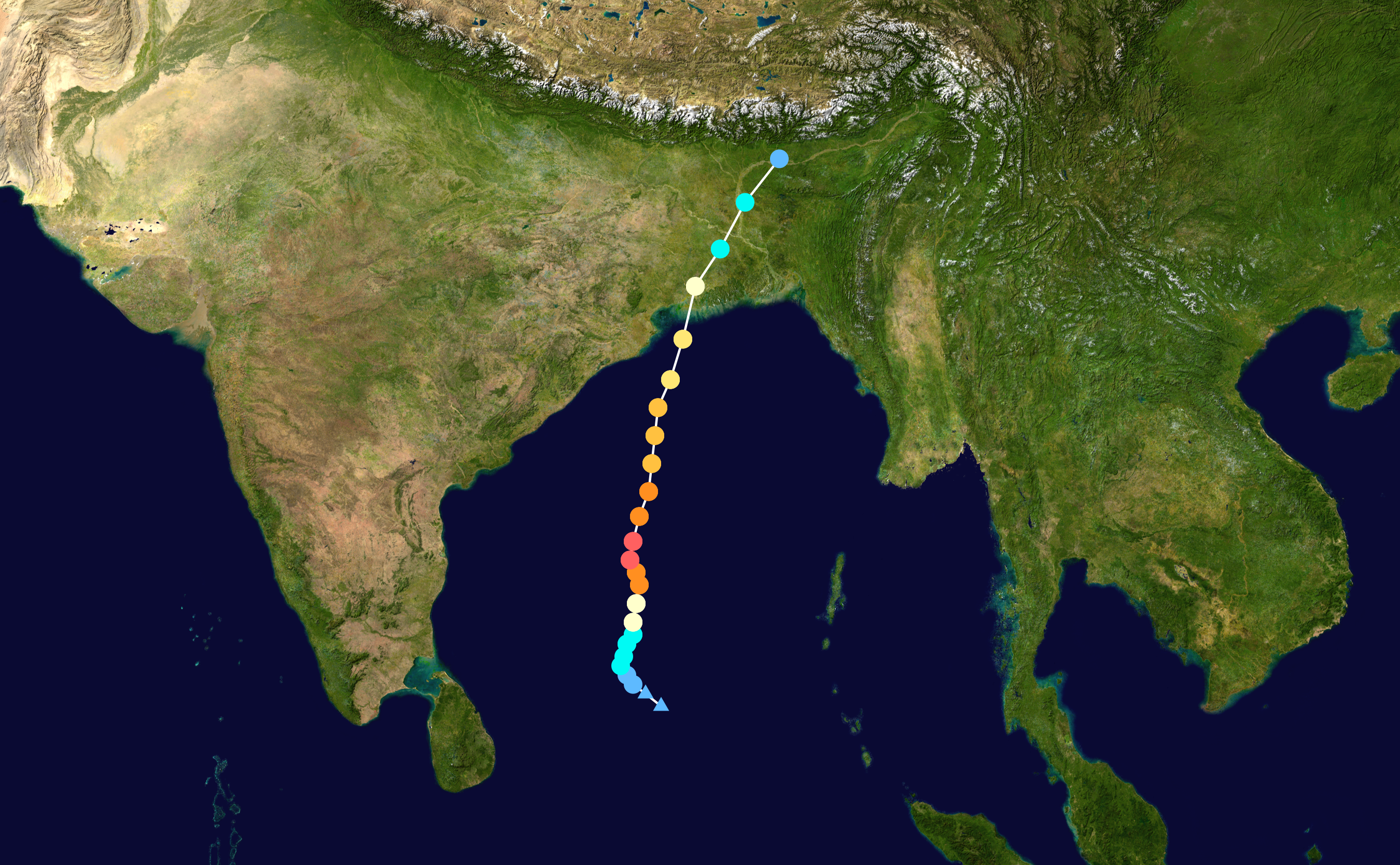
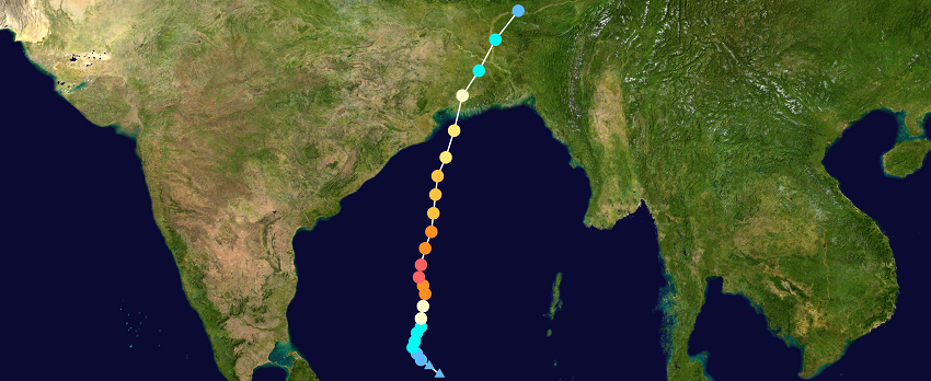
AMPHAN trajectory, source:
NOAA and
NASA
|
 |
While on 17 May, light shear winds in the northern and southern vicinity initially prevented further intensification, the cyclone
underwent and explosive intensification shortly afterwards. Within 6 hours the 1-minute sustained winds increased from 135 kph
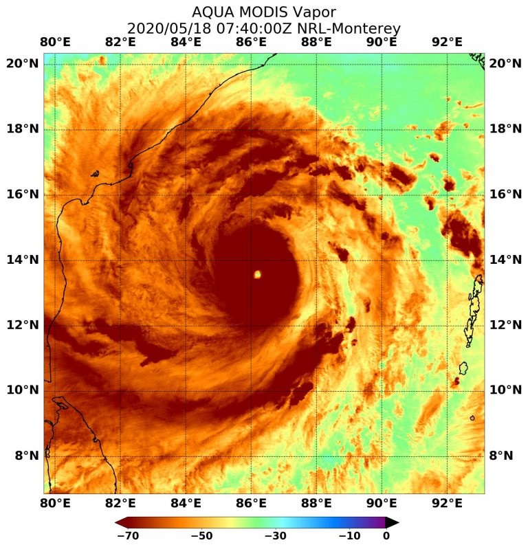
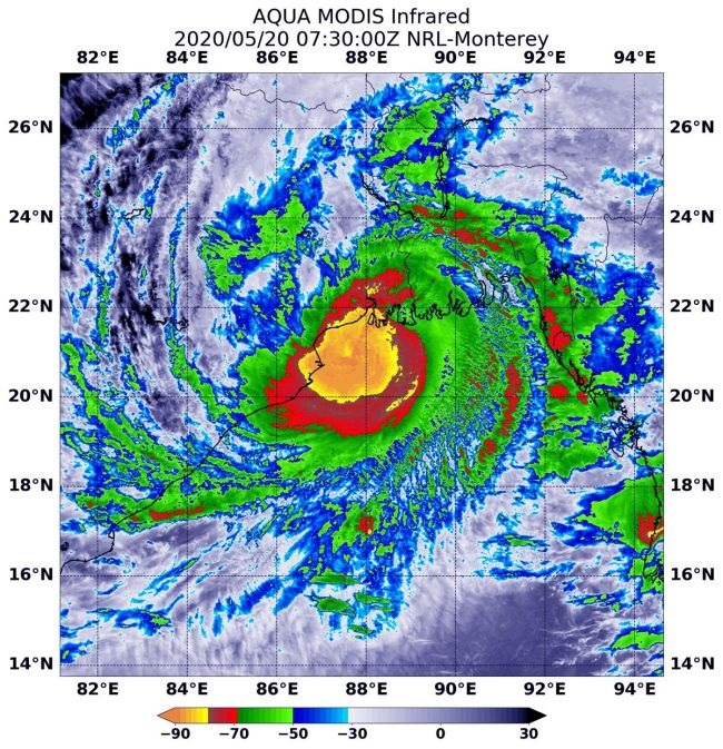
(equals Category 1) to 210 kph (equals Category 4). Another 12 hours later, on 18 May at about 12 UTC, AMPHAN reached its peak
intensity with 1-minute sustained winds of 265 kph, which corresponds to Category 5. This makes AMPHAN the first Super Cyclonic
Storm in the Bay of Bengal since ODISHA (1999) and the second strongest tropical cyclone of 2020 (behind HAROLD with 1-minute
sustained winds of 270 kph).
|
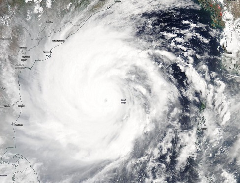
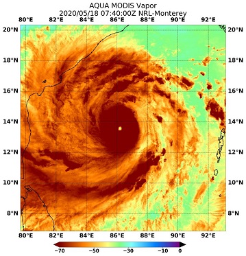
Satellite image and cloud top temperatures at AMPHANs peak intensitiy on 18 May, source:
NASA
|
 |
 |
An incomplete eyewall replacement cycle caused dry mid-level air to be sucked into the centre in the northwestern part of the storm.
The proximity to the Indian peninsula also resulted in increased vertical wind shear due to the adjacent monsoon winds. Under moderate
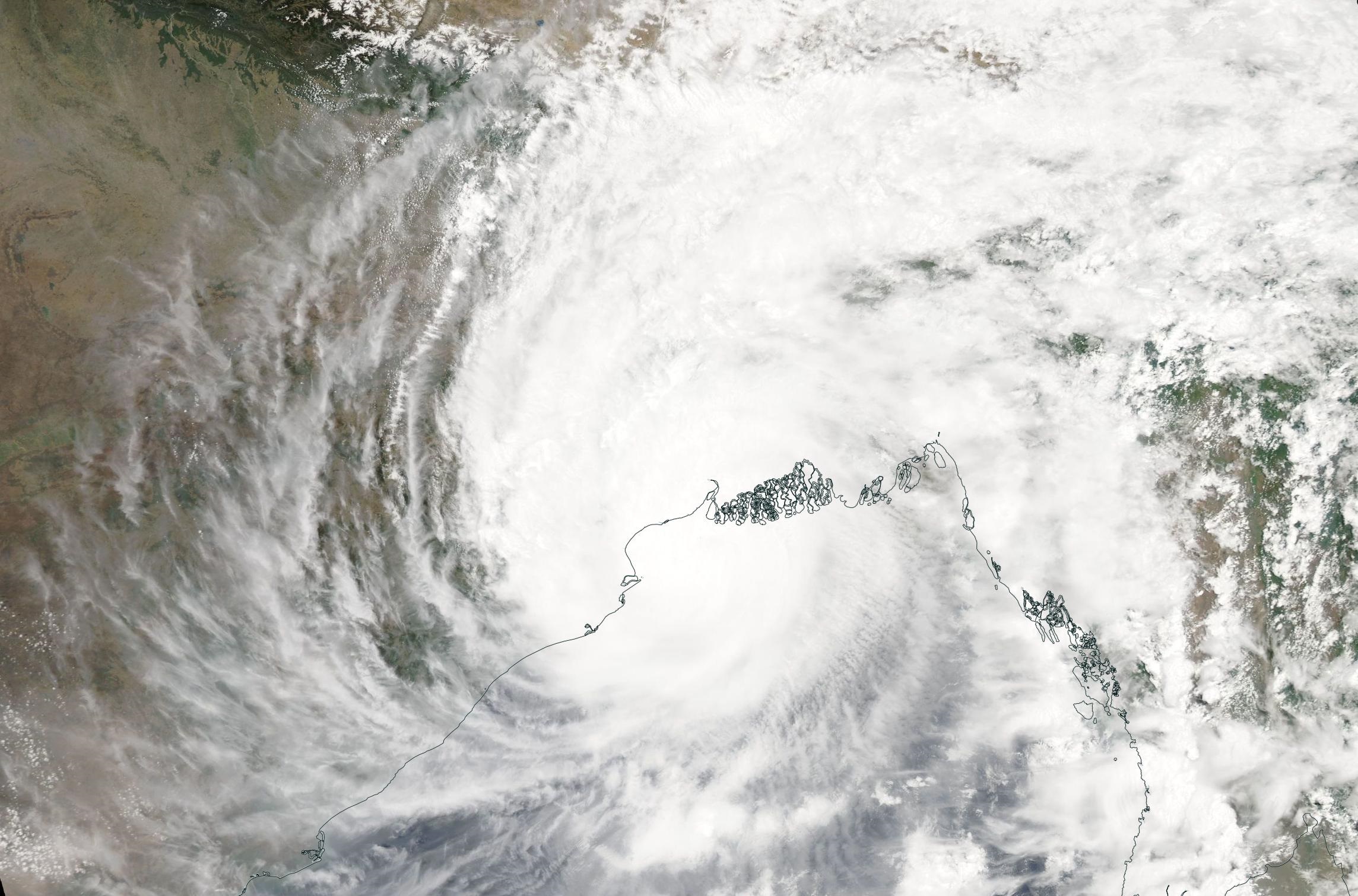
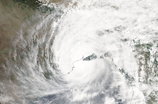
weakening, AMPHAN moved north with a displacement speed of 10-15 kph and made landfall as a Very Cyclonic Storm on 20 May at 12 UTC in
the westernmost part of the Ganges Delta, about 110 km south of Calcutta. The wind speeds at that time were still around 155 kph,
which is category 2 on the Saffir Simpson scale.
|
Satellite image and cloud top temperatures at AMPHANs landfall on 20 May, source:
NASA
|
 |
 |
The stormy winds from AMPHAN caused damage to infrastructure and the electricity network in many coastal areas. The latter, in combination
with the overnight darkness (the land fall occurred late in the evening in local time) made many rescue and evacuation measures difficult.
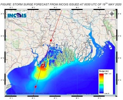
Especially in the area of the Ganges Delta a considerable storm surge of up to 5m occurred. Due to the south-to-north trajectory of the
cyclone and the funnel-like shape of the Bay of Bengal, huge amounts of water were forced into the river mouths. The shallow water depth
in the shore area allows the tide to penetrate far inland. In addition, precipitation of up to 261 mm/24h led to catastrophic flooding.
|
GDACS risk overview and storm surge height, source:
GDACS and
INCOIS
|
 |
 |
In general, the areas bordering the Bay of Bengal are very vulnerable to tropical cyclones. According to a list by
wunderground, 26 of the
35 deadliest tropical cyclones have occurred in the Bay of Bengal. In these storms the high mortality is mainly due to the enormous
storm surges. In the past two decades, 69% of the deaths caused by tropical cyclones worldwide occurred in Bangladesh or India.
The effects of AMPHAN were also felt far inland. In the north of Bangladesh, i.e. on the southern side of the Himalayan Mountains,
there were enormous stagnant rainfalls of up to 162 mm/24h. This precipitation also led to an increase in flooding in the coastal
areas of India and Bangladesh, because the water masses falling from the Himalayan Mountains flowed south into the Ganges Delta.
| Location |
24h Precipitation in mm |
Date |
Paradip (IN)
Digha (IN)
Balasore (IN)
Chandbali (IN)
|
180.0
159.0
118.0
108.0
|
19.05.2020
19.05.2020
19.05.2020
19.05.2020
|
|
| Location |
24h Precipitation in mm |
Date |
Paradip (IN)
Chuadanga (BD)
Mymensingh (BD)
Netrokona Sadar (BD)
Rajarhat (IN)
Tangail (BD)
Bogra (BD)
Barapani (IN)
|
261.0
184.4
151.7
149.4
139.7
130.3
130.0
105.0
|
20.05.2020
20.05.2020
20.05.2020
20.05.2020
20.05.2020
20.05.2020
20.05.2020
20.05.2020
|
|
Text: FS
May 22, 2020
|