Friday, Dec.21st 2018, 23:00 UTC
Storm - Warning
Dec.20th till Dec.22nd 2018
Established on: Thursday, Dec.20th 2018, 15:00 UTC
Storm in Central Europe - Dec.20-Dec.22nd 2018
The start of winter starts in Germany partly very stormy. On Friday December 21st in the course of the day, a low pressure system crosses Germany and brings stormy,
in the south and on exposed sites also gale-force gusts.
Deep STINA II develops in the night from Thursday to Friday on the front of a trough to a storm low.
STINA II brings stormy and rainy weather to Germany at the beginning of winter. Also showers and thunderstorms can be on the backside of the low. Partly there can be heavy rainfall,
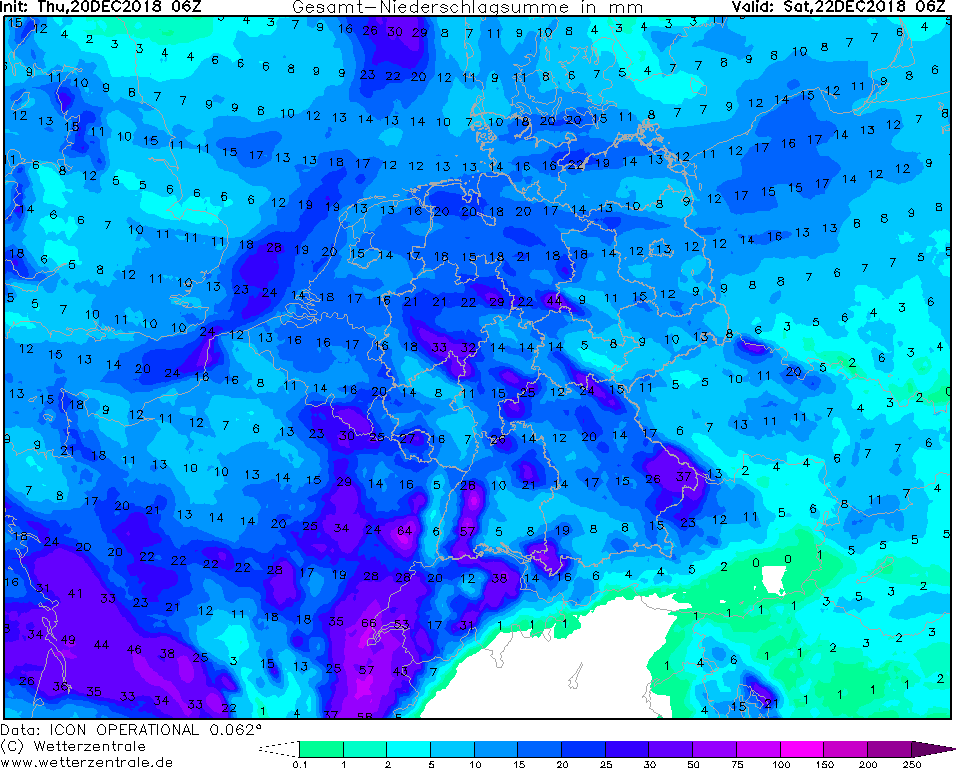
especially on the mountain ranges due to the accumulation of precipitation. In the Black Forest can be precipitation about 60 mm in 48 hours! Beware of rain and thunderstorms.
Here, too, stormy and gale-force gusts can reach the ground due to precipitation.
The first squalls are noticeable in the early morning from the west. Most affected are Saarland, Rhineland-Palatinate, Hessen and southern NRW.
The wind intensifies quickly until noon and then brings in Baden-Württemberg, the first stormy and gale-force gusts. The first stormy gusts were already recorded in
Deuselbach (RP) with 73 km / h (Source: Meteociel). As STINA II is rapidly shifting, the wind calms down until the evening / night. The main storm field extends over
the southeast of Baden-Wuerttemberg and over the middle of Bavaria to the south of Bavaria. In a narrow strip here gale-force gusts over 80 kt / 144 km / h are to be
expected! This shifts from northwest over Baden-Württemberg in the southeast to Bavaria. The warm front has already reached Germany and brings the first precipitation.
In addition to heavy rainfall and strong wind, STINA also brings mild to very mild air around 10 ° C to 12 ° C to Central Europe and therefore also Germany.
This increases the snowfall limit again.
Currently STINA's center with 992 hPa is located at Schleswig-Holstein and will continue to move eastward over Poland. The core pressure will increase slightly
and is about 996 hPa till tomorrow. Tomorrow it remains stormy especially in the south and southeast of Bavaria with about 60kt and 108km / h. In the south it is very
mild with up to 12 ° C, in the middle and in the north with 5-7 ° C also mild.
In Germany mostly changeable weather with showers and thunderstorms, which shift in the course of the day until the evening in the southeast. These can bring rain
and snow at higher altitudes. Furthermore, there is danger of stormy gusts near thunderstorms and showers.
There was already measured gale gusts on the Feldberg 137 km / h and absolute leader is the Brocken with 155 km / h! (Source: Meteociel)
German Version
Friday, Dec.21st 2018, 09:00 UTC
Storm - Warning
Dec.20th till Dec.22nd 2018
Established on: Thursday, Dec.20th 2018, 15:00 UTC
Storm in Central Europe - Dec.20-Dec.22nd 2018
The start of winter starts in Germany partly very stormy. On Friday December 21st in the course of the day, a low pressure system crosses Germany and brings stormy,
in the south and on exposed sites also gale-force gusts.
Deep STINA II develops in the night from Thursday to Friday on the front of a trough to a storm low.
STINA II brings stormy and rainy weather to Germany at the beginning of winter. Also showers and thunderstorms can be on the backside of the low. Partly there can be heavy rainfall,
especially on the mountain ranges due to the accumulation of precipitation. In the Black Forest can be precipitation about 60 mm in 48 hours! Beware of rain and thunderstorms.
Here, too, stormy and gale-force gusts can reach the ground due to precipitation.
The first squalls are noticeable in the early morning from the west. Most affected are Saarland, Rhineland-Palatinate, Hessen and southern NRW.
The wind intensifies quickly until noon and then brings in Baden-Württemberg, the first stormy and gale-force gusts. The first stormy gusts were already recorded in
Deuselbach (RP) with 73 km / h (Source: Meteociel). As STINA II is rapidly shifting, the wind calms down until the evening / night. The main storm field extends over
the southeast of Baden-Wuerttemberg and over the middle of Bavaria to the south of Bavaria. In a narrow strip here gale-force gusts over 80 kt / 144 km / h are to be
expected! This shifts from northwest over Baden-Württemberg in the southeast to Bavaria. The center moves to the newest model runs from the North Sea over the north
and northeast of Germany. The warm front has already reached Germany and brings the first precipitation. The storm track can still change until it reaches Germany.
In addition to heavy rainfall and strong wind, STINA also brings mild to very mild air around 10 ° C to 12 ° C to Central Europe and therefore also Germany.
This increases the snowfall limit again.
Currently, STINA II is just a wave disturbance and is located northwest of Germany over the UK. It develops as a marginal depression of STINA I, which is
located north of the UK. The pressure in the center is currently 994 hPa and will not deepen further. STINA II is rapidly migrating eastwards towards Europe, but
hardly intensifies due to the unfavorable position on the right-hand jet exit. The stormy winds are mainly caused by the strong gradient.
German Version
Thursday, Dec.20th 2018, 15:00 UTC
|

|
|
|
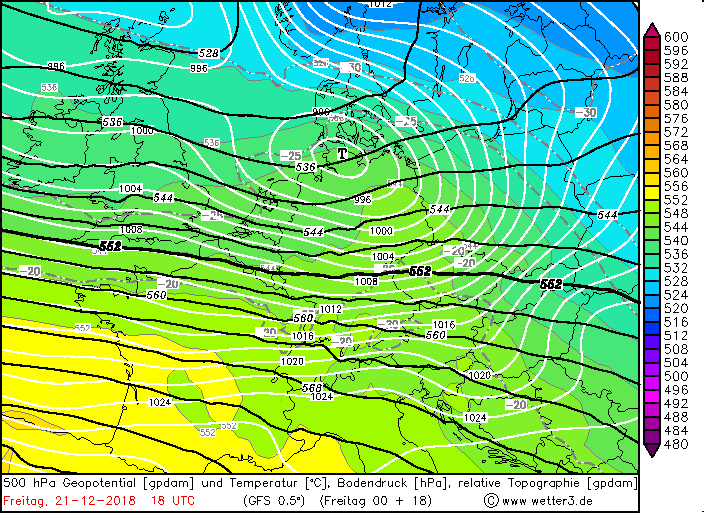
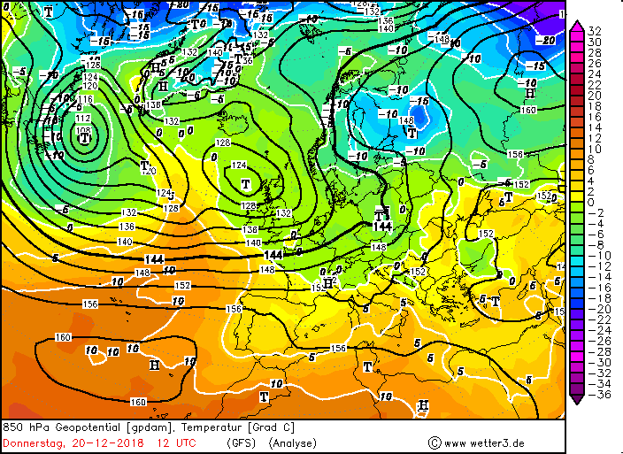
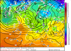
850 hPa Geopot. und Temp., 20.12., 12 UTC
Source: Wetter3
|
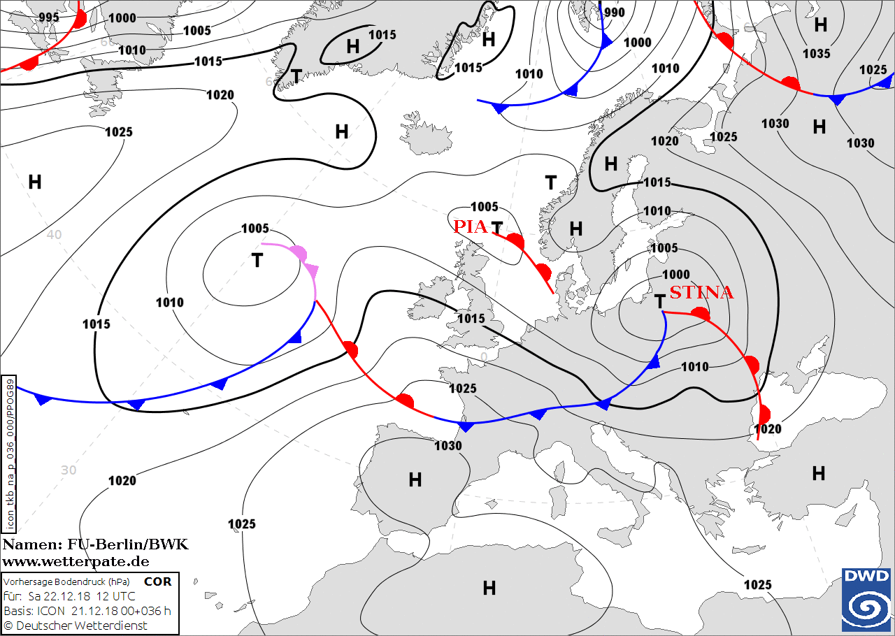
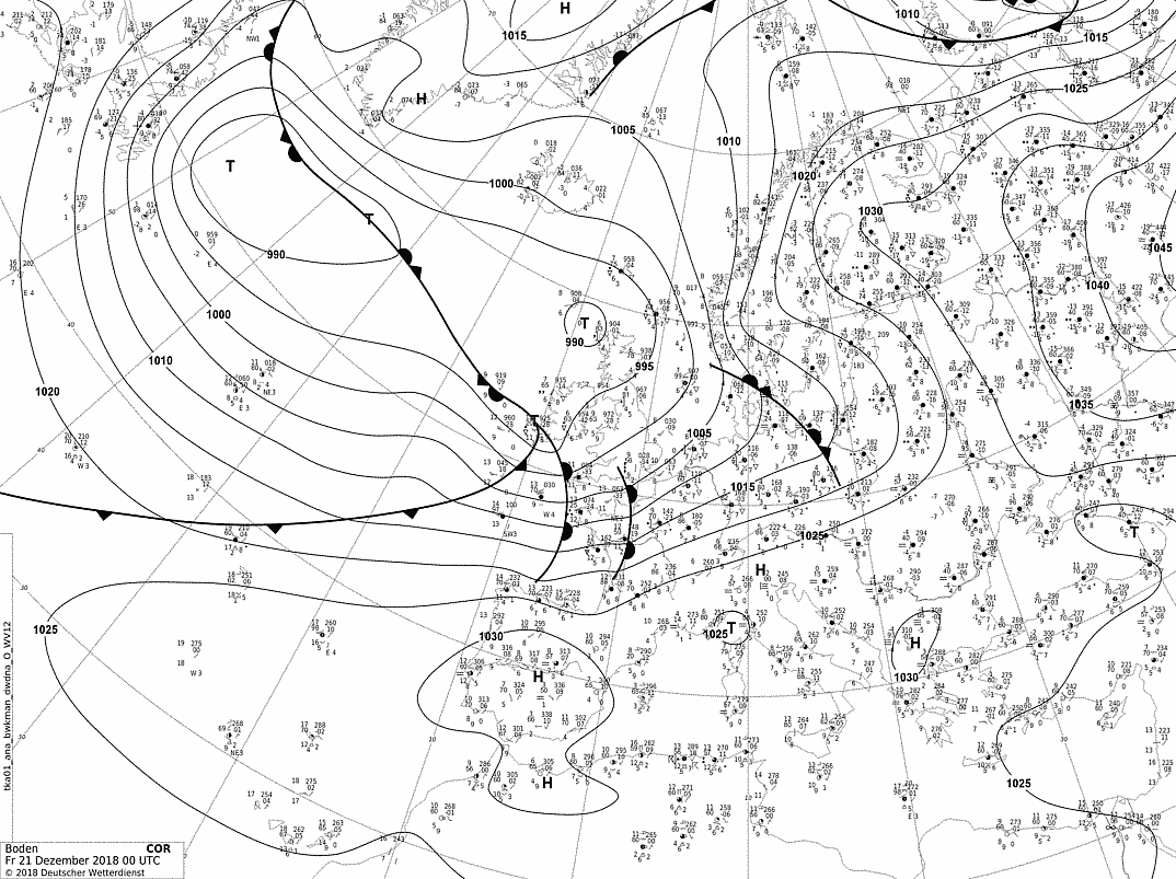
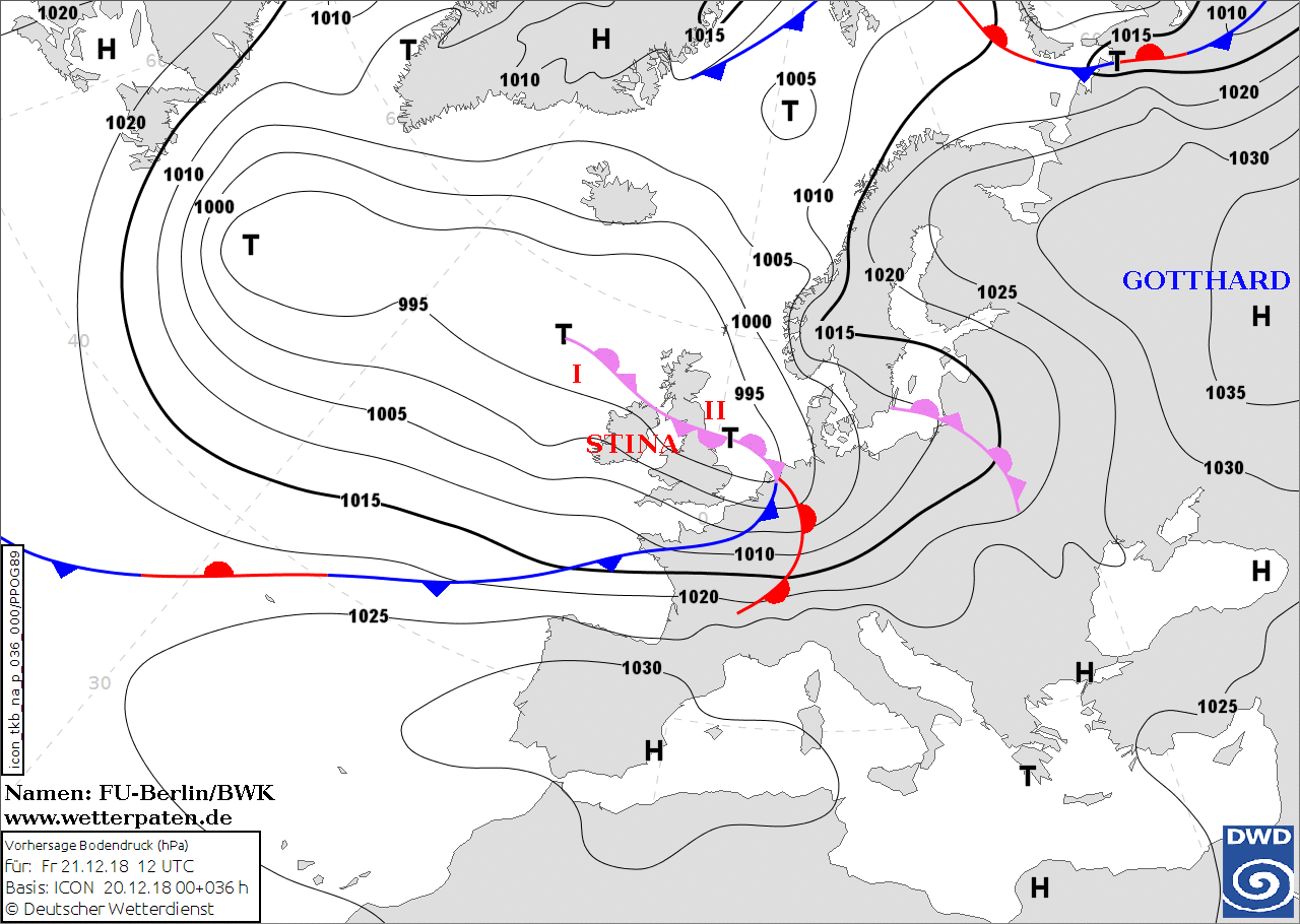
Sea Level Pressure forecast, 21.12., 12 UTC
Source: FU Berlin
|
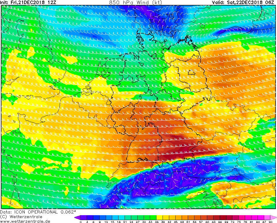
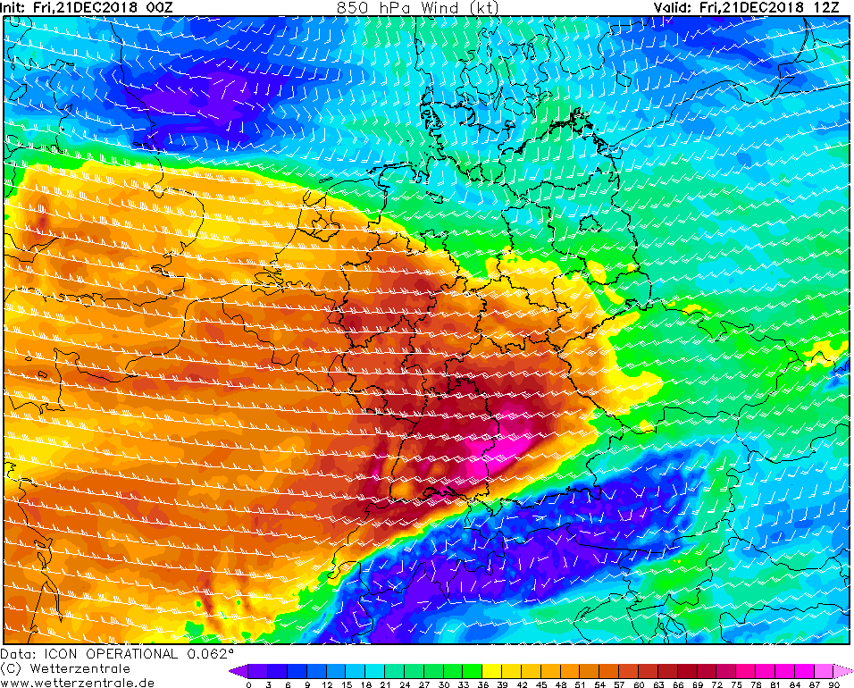
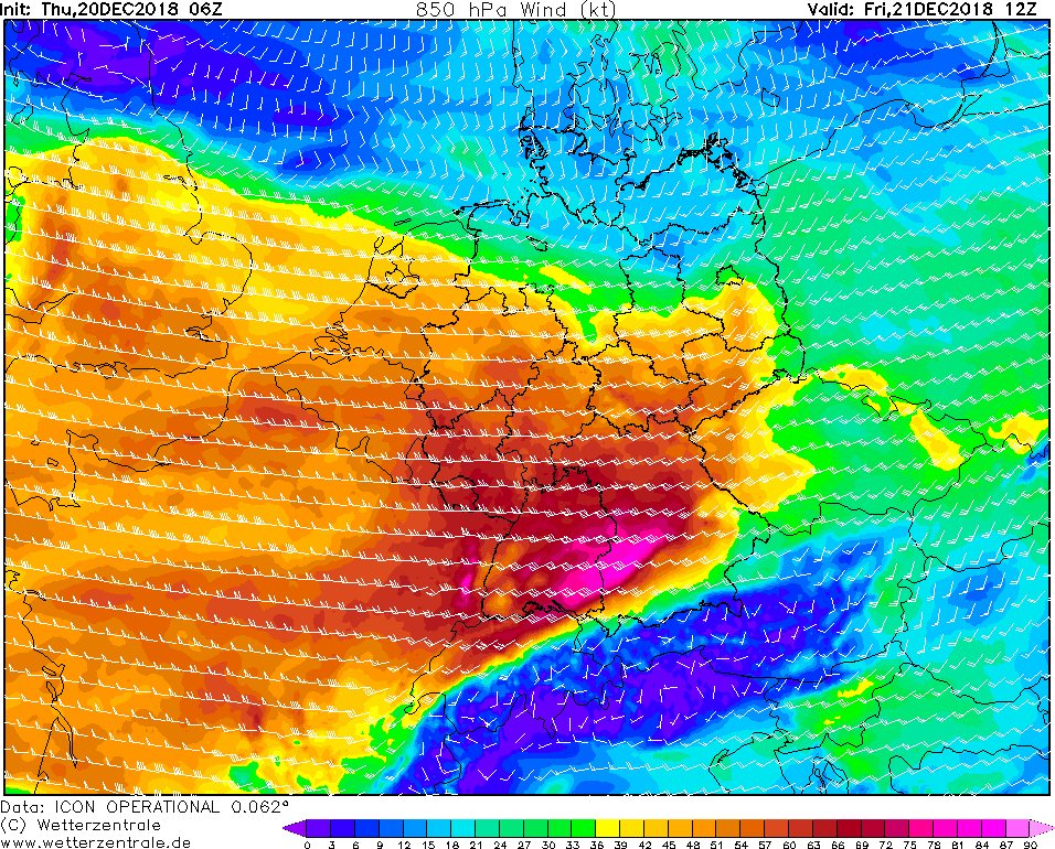
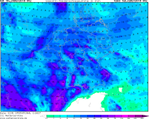
850 hPa Wind, 21.12., 12 UTC
Source: Wetterzentrale
|
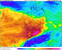
48 hours precipitation from Dec.20th
06 UTC till Dec.22nd 06 UTC
Source: Wetterzentrale
|
Storm - Warning
Dec.20th till Dec.22nd 2018
Established on: Thursday, December 20th 2018, 15:00 UTC
Storm in Central Europe - Dec.20th-Dec.22th 2018
The start of winter starts in Germany partly very stormy. On Friday December 21st in the course of the day, a low pressure system crosses Germany and brings stormy,
in the south and on exposed sites also gale-force gusts. Deep STINA II develops in the night from Thursday to Friday on the front of a trough to an storm low.
STINA II brings stormy and rainy weather to Germany at the beginning of winter. Also showers and thunderstorms can be on the backside of the low. Partly there can be heavy
rainfall, especially on the mountain ranges due to the accumulation of precipitation. In the Black Forest there can be precipitation about 60 mm in 48 hours! Beware of rain and
thunderstorms. Here, too, stormy and gale-force gusts can reach the ground due to precipitation.
The first squalls are noticeable in the early morning from the west. Most affected are Saarland, Rhineland-Palatinate, Hessen and southern NRW. The wind intensifies
quickly until noon and then brings in Baden-Württemberg, the first stormy and gale-force gusts. As STINA II shifts rapidly, the weather calms down with respect to
the wind until the evening / night. The main storm field extends over the southeast of Baden-Wuerttemberg and over the middle of Bavaria to the south of Bavaria.
In a narrow strip here gale-force gusts over 90 kt / 162 km / h are to be expected! This shifts from northwest over Baden-Württemberg in the southeast to Bavaria.
The center moves to the latest model runs over the North and Baltic Sea and the north of Germany. Stormy gusts are less to be expected here. The storm track can still
change until it reaches Germany.
In addition to heavy rainfall and strong winds, STINA also brings mild to very mild air around 10 ° C to 12 ° C to Central Europe and therefore also Germany.
This increases the snowfall limit again.
At the moment, STINA II is just a wave disruption and is located west of the UK over the Atlantic. It develops as a marginal depression of STINA I, which is located
above the north of the UK. The wave disturbance can be seen very well in the temperature maps as a temperature wave. The southern warm air already protrudes pointedly
into the northern cold air. The pressure in the center is currently 995 hPa. STINA II is rapidly migrating eastwards towards Europe, but hardly intensifies due to the
unfavorable position on the right-hand jet exit. The stormy winds are mainly caused by the strong gradient.
German Version
established on: December 20th 2018, 15:00 UTC
MG
|