|
Storm Éowyn was the worst storm to affect Ireland in the past decades. After a period of explosive cyclogenesis, hurricane-force winds impacted most of the British Islands on January 24, 2025. In Western Ireland, the measuring site at Mace Head provisionally broke the Irish wind record with a peak wind gust of 183 kph before measurements stopped.
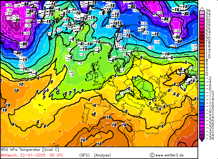
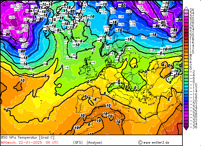
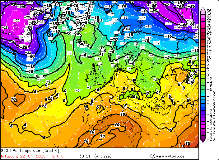
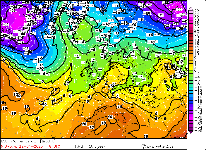
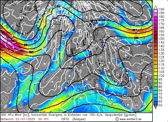
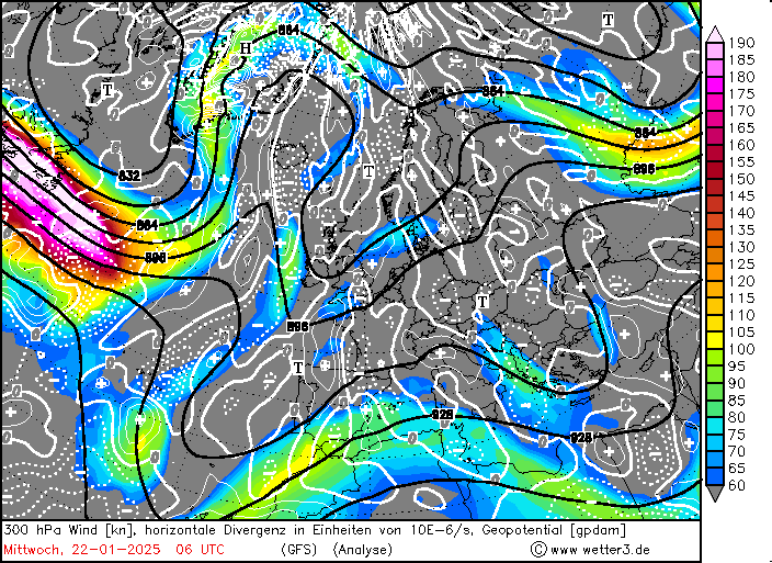
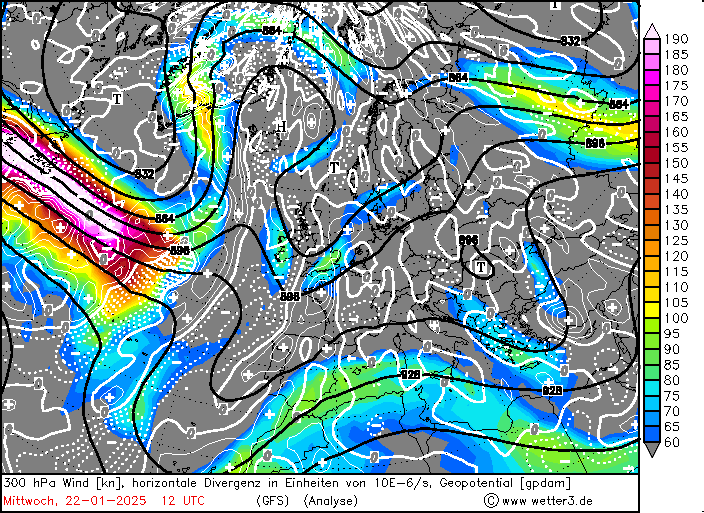
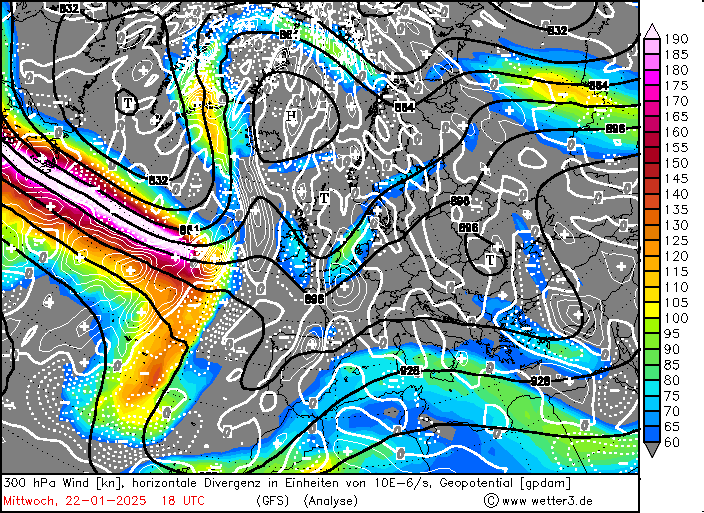
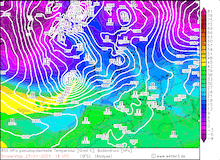
A small low-pressure system developed along the US Gulf Coast by January 21, 2025. Said low-pressure system was part of a sharp air mass boundary which brought a record-breaking blizzard to the US Gulf Coast. Within a few days, this low-pressure system developed into one of the worst winter storms impacting Europe in the past decades. With the severe cold snap over North America, a sharp air mass boundary developed over the Northern Atlantic. Here, polar air masses met subtropical air masses. The distinct meridional temperature gradient induced a strong jet streak over the Northern Atlantic.
|
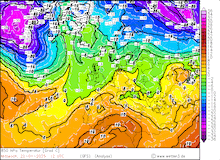
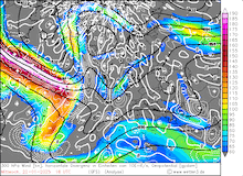
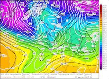
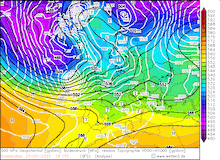
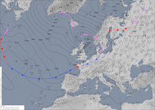
Development of jet streak over the Northern Atlantic seen in the 300 hPa wind and divergence patterns (upper row) and the inducing temperature gradient near Newfoundland seen in the 850 hPa temperature (lower row) over Europe, 22.01.2025 00 UTC - 22.01.2025 18 UTC, source:
wetter3.de
|
 |
 |
 |
 |
 |
 |
 |
 |
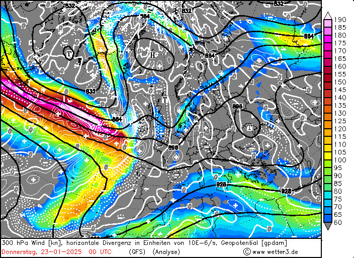
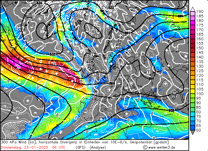
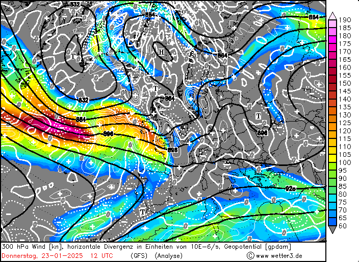
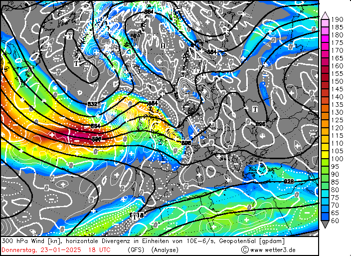
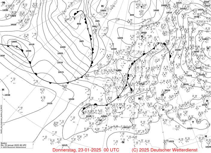
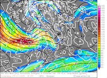
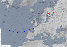
On January 22, 2025, the low moved along the US Atlantic Coast. South of Newfoundland, the low-pressure system started to travel along the sharp air mass boundary over the Northern Atlantic. In the upper troposphere, a strong jet streak spanned across the Atlantic from Newfoundland to the British Isles. Within the jet streak, 300 hPa wind speeds reached nearly 400 kph according to NWP analysis. The low was located beneath the right entry quadrant of the jet streak. Classic synoptic diagnostics show that in this area of a jet streak upper-level divergence will be present. This divergence is induced by the acceleration of the wind creating a strong ageostrophic wind component.
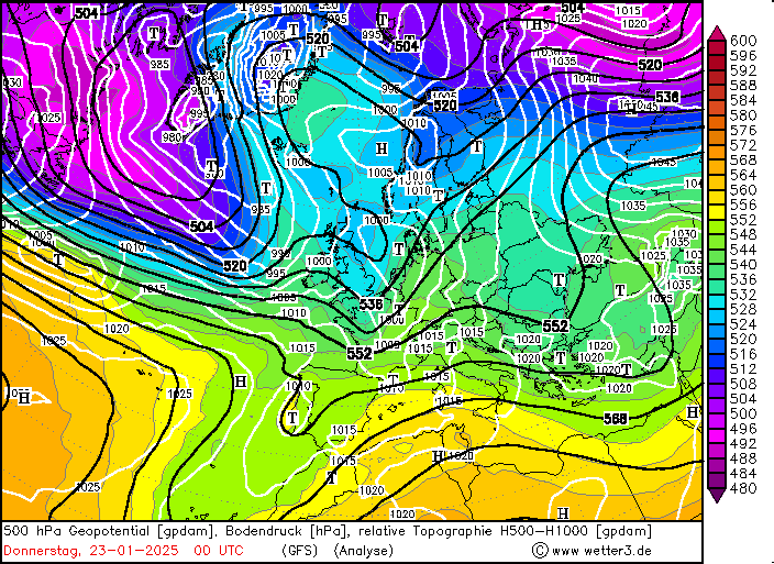
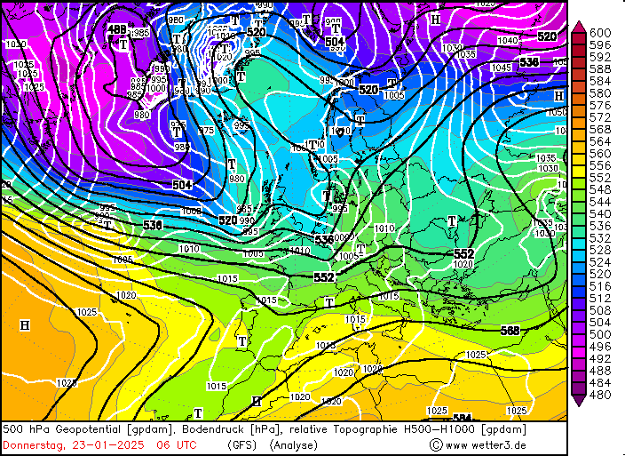
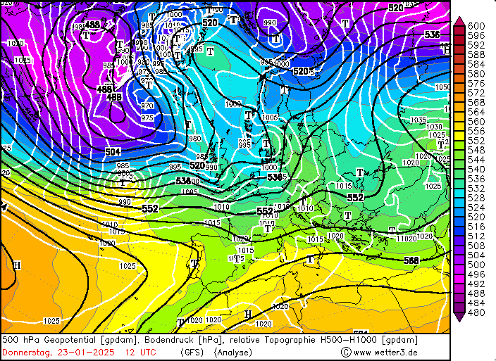
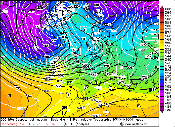
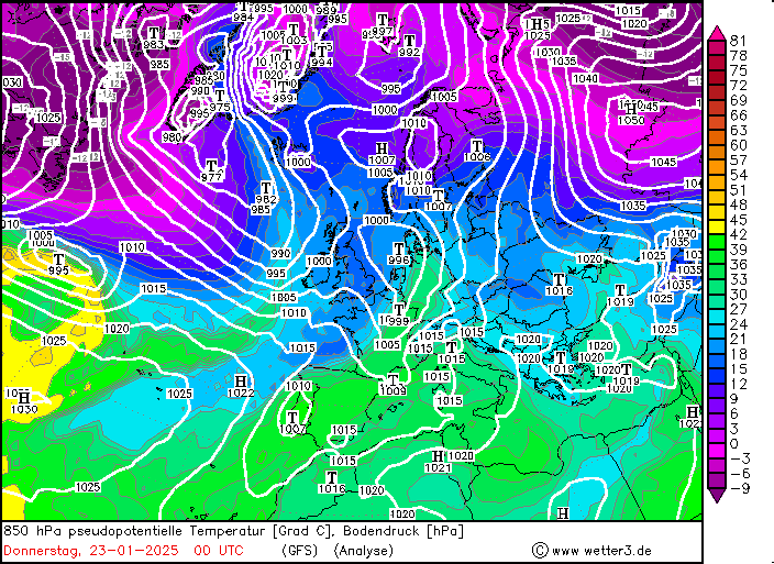
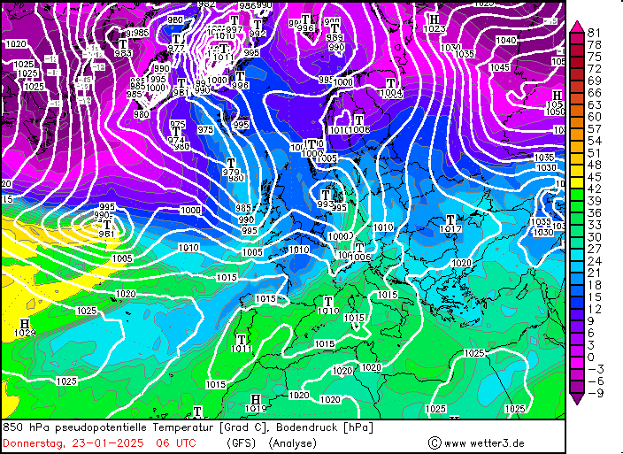
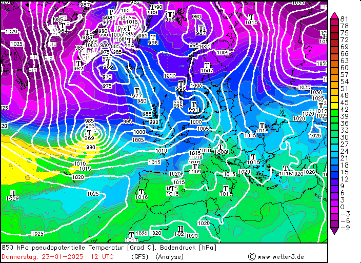
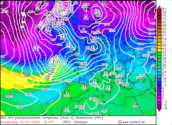
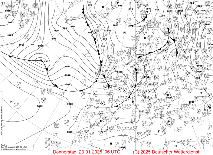
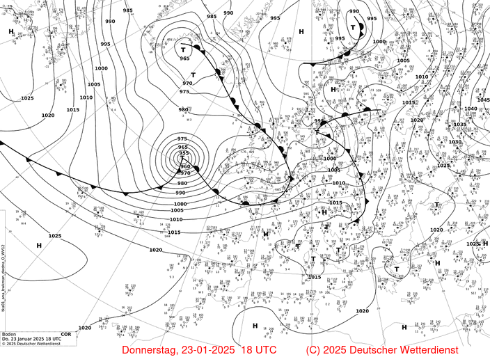
By 00 UTC on January 23, 2025, the central pressure of the low was just below 1000 hPa. Aided by the strong upper-level divergence, the surface low quickly intensified in the following day. Within a 24 h period, the central pressure of Storm Éowyn dropped extremely quickly. At 00 UTC on January 24, 2025, the central pressure of Storm Éowyn reached below 945 hPa. This is an extreme example of explosive cyclogenesis as the central pressure dropped by more than 60 hPa/24 h. At the same time, the low was advected across the entire North Atlantic, roughly 4000 km, by the high winds of the jet streak.
|
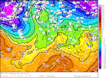
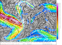
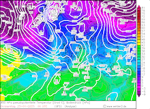
Development of the 300 hPa wind and divergence (first row), 500 hPa geopotential, 1000 hPa to 500 hPa thickness , and sea-surface pressure (second row), 850 hPa pseudo-potential temperature and sea-surface pressure (third row), and surface analysis and sea-surface pressure (fourth row) over Europe during the explosive cyclogenesis of Storm Éowyn, 23.01.2025 00 UTC - 23.01.2025 18 UTC, source:
wetter3.de
|
 |
 |
 |
 |
 |
 |
 |
 |
 |
 |
 |
 |
 |
 |
 |
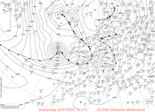 |
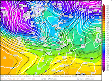
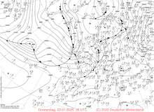
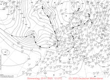
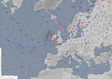
Analyzing the period of explosive cyclogenesis of Strom Éowyn more closely, the relative position of the low to the jet streak becomes of great importance. Upon entering the jet streak, Storm Éowyn was located below the right entry quadrant of the jet streak. Throughout January 23, 2025, the air mass boundary over the North Atlantic was increasingly bent by Storm Éowyn. A distinct warm sector developed ahead of the low-pressure system. By the end of the day, Storm Éowyn had moved to the polar side of the jet streak. In this area, the upper-level dynamics create divergence which helped to further intensify the cyclone. This crossing of the jet axis is a trademark characteristic of Shapiro-Keyser cyclones.
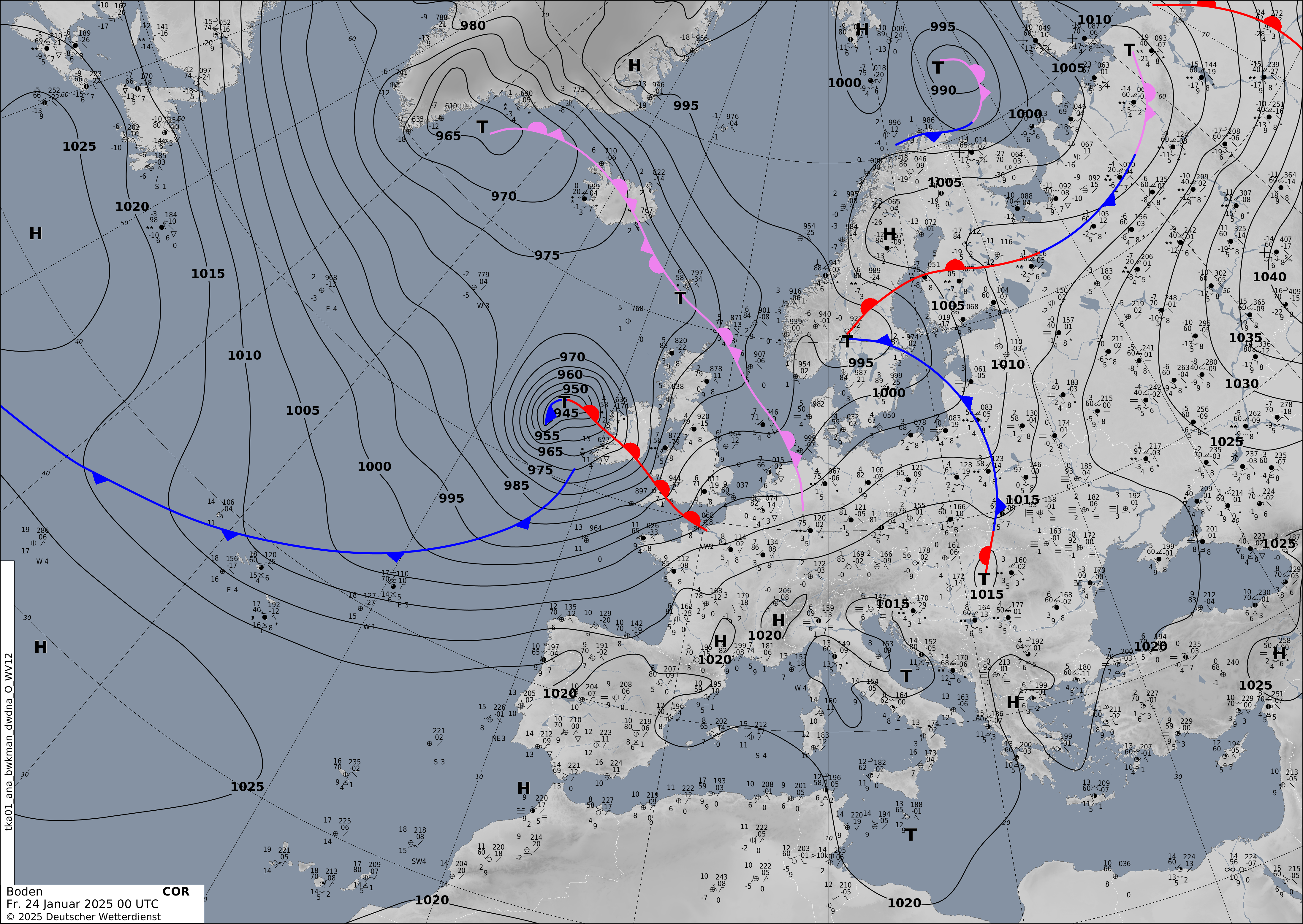
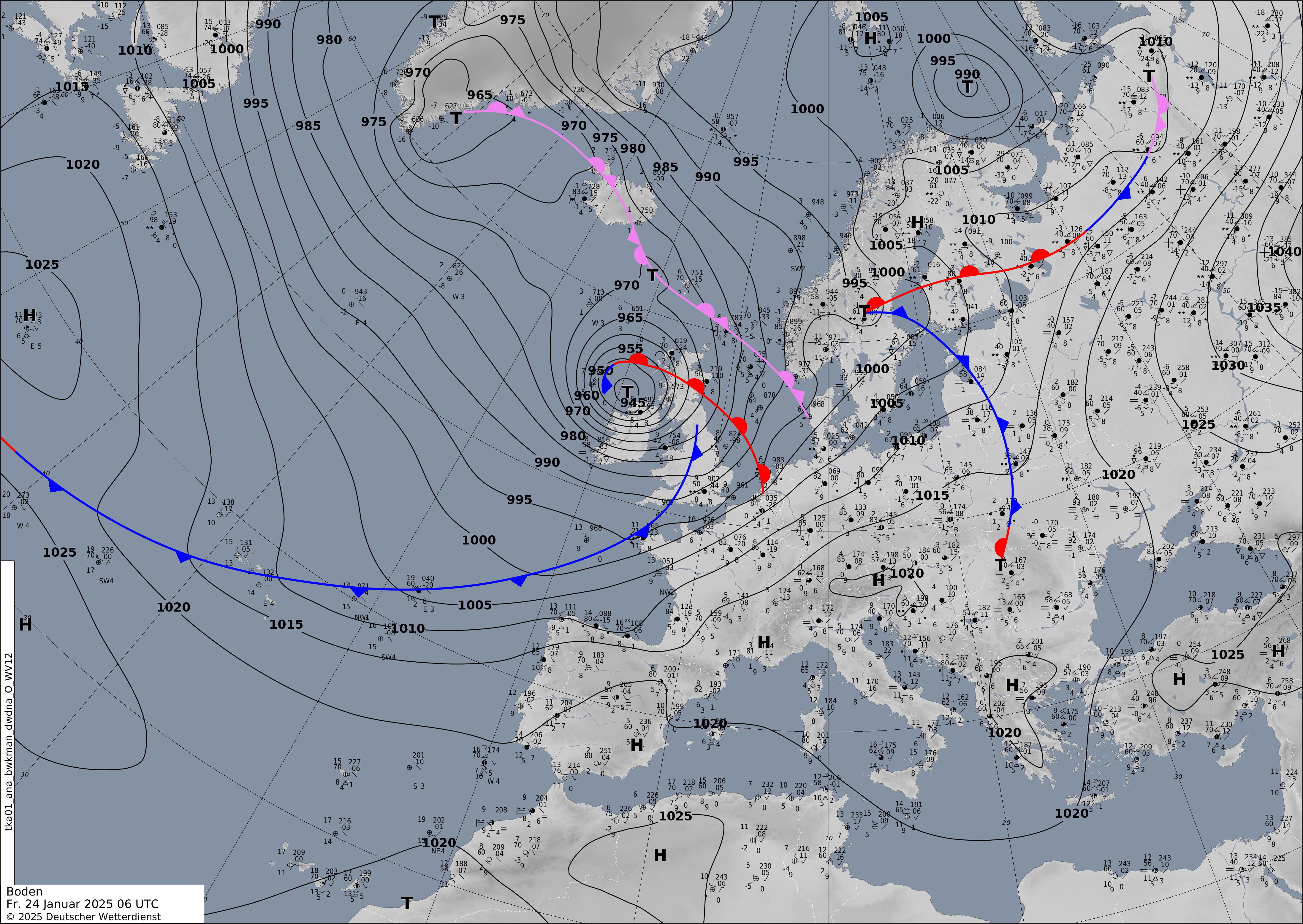
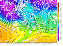
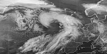
Shapiro-Keyser cyclones typically feature a rather weak cold front that runs ahead of the low-pressure system and is displaced to the southeast of the pressure center. Further, it is observed that the warm front extends past the center of the low-pressure system. Interpreting the surface analysis by the German Weather Services at 00 UTC on January 24, 2025, these typical features were identified by the forecasters. With the bent-back warm front, a distinct cloud head can develop. This cloud head is located at the front of a coherent cloud band stretching around the center of the low. At the tip of the cloud head, distinct finger-like structures indicate the potential occurrence of a sting jet. This is a coherent airflow at the tip of the cloud of a Shapiro-Keyser cyclone which descends from the upper troposphere into the lower troposphere. When a sting jet penetrates through the boundary layer, extreme wind speeds can be observed over confined areas. A sting jet typically occurs when the bent-back warm front wraps around the cyclone center. It ceases to exist when the bent-back warm front fully encapsulates the warm air masses in the cyclone center.
|
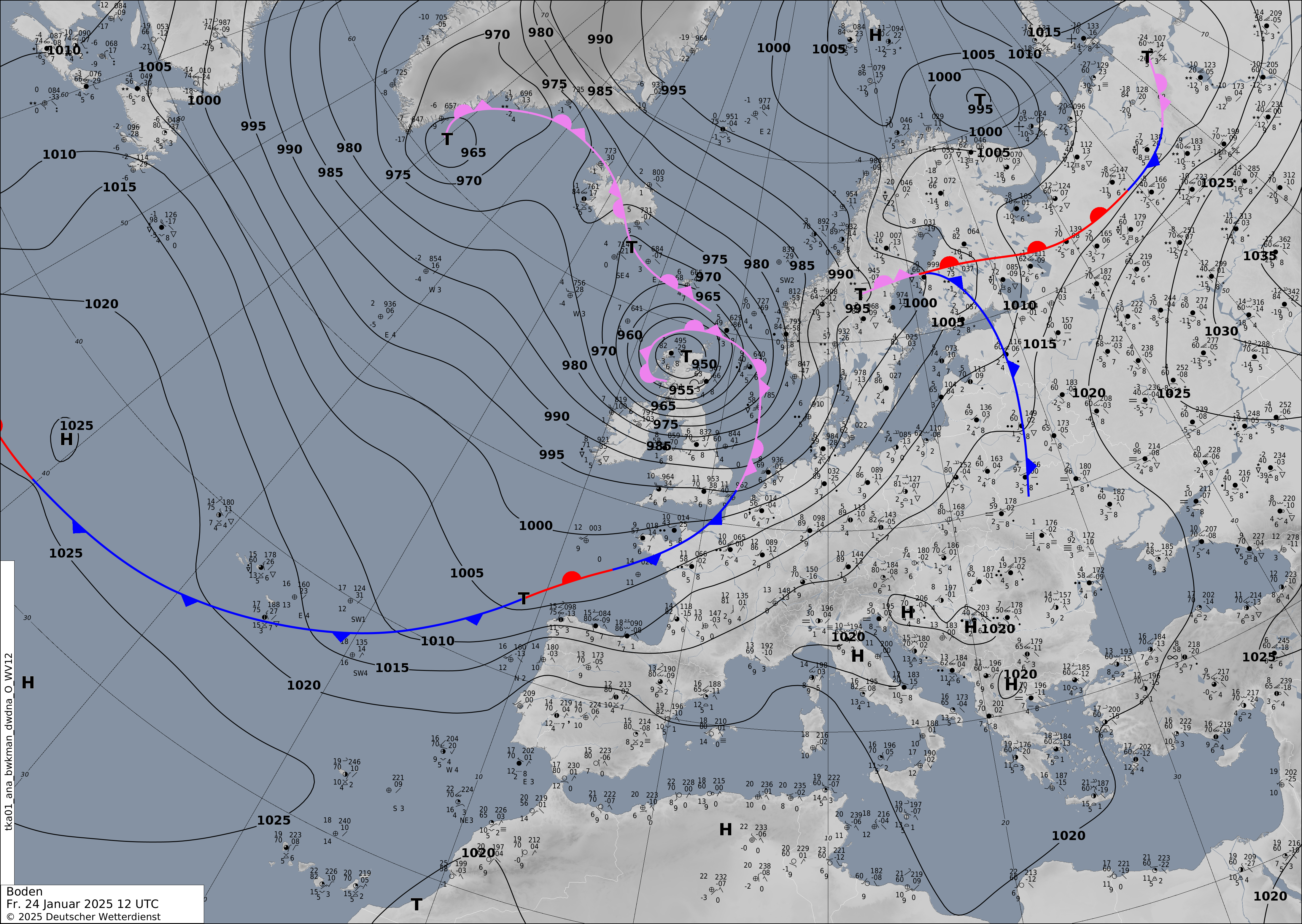
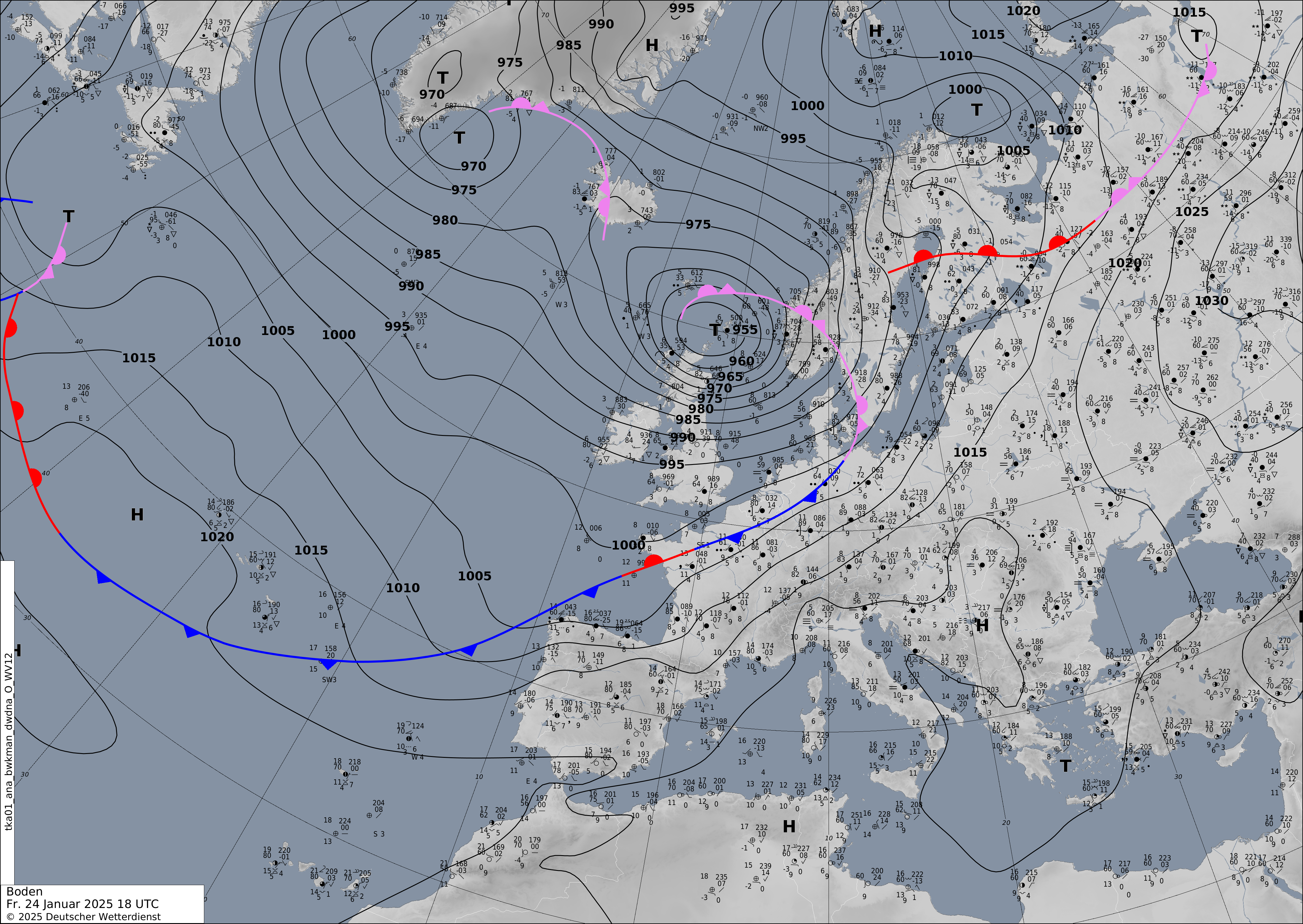
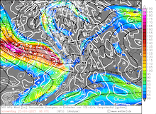
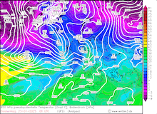
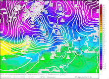
Development of the analyzed fronts and sea-surface pressure over Europe during the passage of Storm Éowyn across the British Isles, 24.01.2025 00 UTC - 24.01.2025 18 UTC, source: DWD
|
 |
 |
 |
 |
At exposed locations further inland in Ireland, extreme wind gusts of more than 150 kph were measured. Up until 14 UTC on January 24, 2025, hurricane-force wind gusts were observed on the entire island of Ireland. By midday, the storm field of Storm Éowyn shifted eastwards into Great Britain. South of the Highlands in Scotland and in Northern England, hurricane-force wind gusts occurred. With a wind gust of 127.8 kph, the international airport on the Isle of Man recorded the highest wind gust in 20 years. All ship and air connections to the island were suspended during the passage of Storm Éowyn.
|
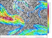
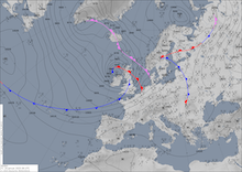
Development of Storm Éowyn over the Northern Altantic and the British Isels seen in the 10.8 µm satellite imagery showing trademark characteristics of a Shapiro-Keyser cyclone, 23.01.2025 14 UTC - 24.01.2025 20 UTC, source:
EUMETSAT View
|
 |
 |
 |
 |
 |
 |
 |
 |
 |
 |
 |
 |
 |
 |
 |
 |
Over Great Britain, the hurricane-force wind gusts of Storm Éowyn continued in the afternoon hours of January 24, 2025. Both along the Irish Channel and the North Sea, wind gusts of more than 130 kph were measured. At the higher elevations of the Pennines in Northern England and the Highlands in Scottland, extreme wind gusts occurred. At the Great Dun Fell, the second-highest peak in the Pennines with an altitude of 848 m, a measuring gauge recorded a peak wind gust of 194.5 kph. Further north in the Highlands of Scotland, the intensity of Storm Éowyn was even greater. The measuring gauge at the Cairnwell mountain at an altitude of 928 m recorded a peak wind gust of 217 kph. While the winds of Storm Éowyn peaked at 12 UTC at the Great Dun Fell, the highest wind gust atop the Cairnwell Mountain was only measured by 22 UTC on January 24, 2025. The temporal discrepancy of the highest wind gusts at the two exposed mountain tops may be an indicator that these might have been induced by different features in the cyclone.
This observation is further supported by the measurements in-between an area spanning from Glasgow and Edinburgh in the north and Liverpool and Sheffield to the south. In this part of Great Britain, the highest wind gusts of Storm Éowyn occurred during the midday and afternoon hours. Most stations in this area recorded wind gusts of more than 120 kph. In the northern parts of Scotland, exposed locations measured hurricane-force winds in the evening and night-time hours of January 24, 2025. An outlier in the slightly weaker wind gusts in Northern Scotland are the extreme wind measurements atop the Cairnwell mountain. Nevertheless, these observations further support the thesis that the winds in these areas might have been induced by different features of the cyclone.
|
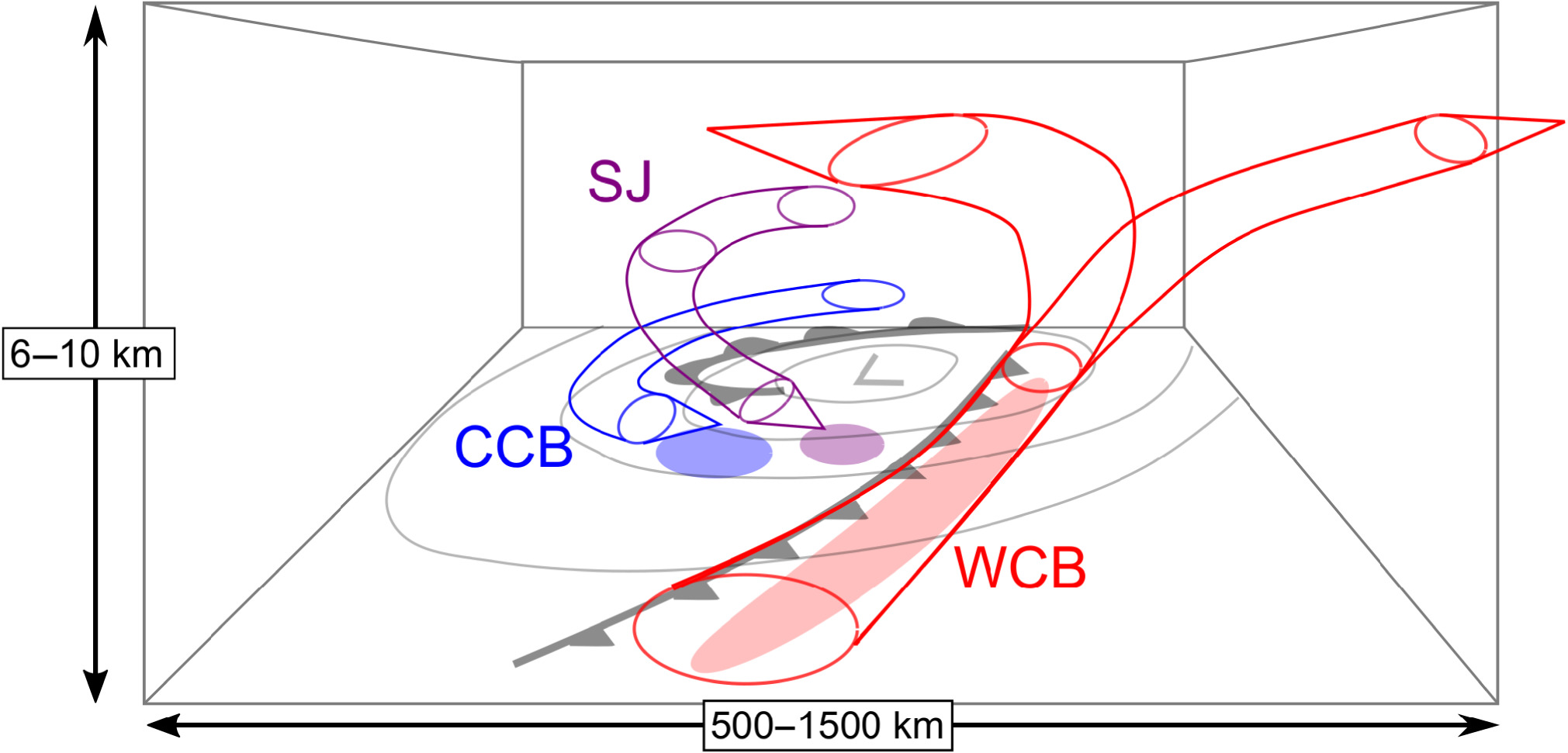
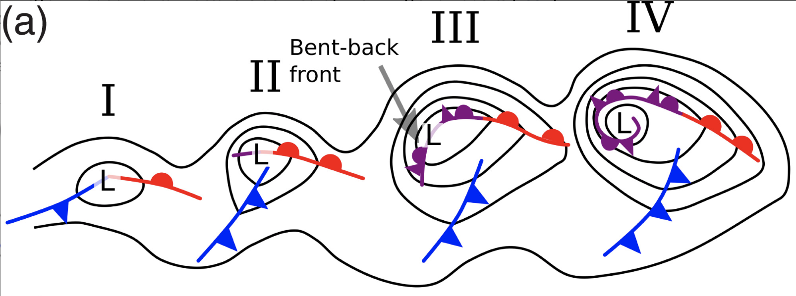
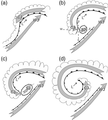
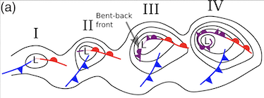
Schematic view of a Shapiro-Keyser cyclone near peak intensity showing the coherent air streams within the cyclone, WCB: warm conveyor belt, CCB: cold conveyor belt, SJ: sting jet (left, Fig. 7), schematic frontal development of a Shapiro-Keyser cyclone (middle, Fig. 1a), and schematic development of the jets within a Shapiro-Keyser cyclone during its lifecycle, WJ: warm jet, CJ: cold jet, SJ: sting jet (right Fig. 2), source: Clark and Gray (2018)
|
 |
 |
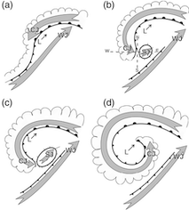 |
In combination with the finger-like structures that have been captured by satellite imagery, an assumption might be plausible that a sting jet may have reached the surface during the passage of Storm Éowyn. The schematic drawing above shows the different coherent air streams occurring in a Shapiro-Keyser cyclone. One can see that the pattern in the observational data hints that the high wind gusts in the morning and midday hours over Ireland and Central Great Britain might have been caused by the presence of a sting jet. The high wind speeds in the evening hours over Northern Scotland might have been related to the cold jet wrapping around the cyclone center. This phenomenon can also be seen in the schematic life cycle of a Shapiro-Keyser cyclone above.
By January 25, 2025, Storm Éowyn moved across the Norwegian Sea. Along the coast of Southern Norway, hurricane-force wind gusts were measured. At exposed locations along the coast and higher elevations in the Southern Scandinavian Mountains, wind gusts of more than 130 kph were measured. At Krakenes along the Atlantic Coast, a peak wind gust of 163 kph was recorded at 10 UTC. By January 26, 2025, Storm Éowyn had moved further northwards across the Norwegian Sea and assimilated into a broad low-pressure area east of Iceland.
Storm Éowyn was one of the most severe windstorms that affected Europe in the last decades. With wind gusts of more than 180 kph, Storm Éowyn was the worst storm to impact Ireland since Hurricane DEBBIE in 1961. For the first time since Hurricane ORPHELIA in 2017, the Hurricane Hunters were stationed in Europe to gather aircraft reconnaissance data of the rapidly intensifying storm. With an explosive intensification of more than 60 hPa/24 h, Storm Éowyn had one of the most severe explosive intensification cycles observed over the Northern Atlantic. In Ireland, more than 1,000,000 people were left without power after Storm Éowyn. Days after the passage of Storm Éowyn, hundreds of thousands of customers were still without power. Significant impacts on the water infrastructure were also reported across Ireland. On the British Isles, significant wind damage occurred in forests. Further, hundreds of flights were canceled during the passage of Storm Éowyn. At least 2 fatalities have been related to Storm Éowyn.
Text: KG
January 30, 2025
|