|
Hurricane MILTON was an extremely powerful category 5 hurricane undergoing an extreme rapid intensification cycle over the Gulf of Mexico. At peak instensity, Hurricane MILTON had a central pressure of 897 hPa and sustained winds of 285 kph. At landfall, the sustained winds of Hurricane MILTON decreased to 195 kph. The hurricane brought a severe storm surge to the Floridian Gulf Coast as it made landfall near Siesta Key, FL. Additionally, Hurricane MILTON spawned several tornadoes in Southern Florida before its landfall.
The tropical disturbance which would eventually mature into Hurricane MILTON descended from another tropical depression over the Pacific Ocean. Tropical Depression 11E formed over the Pacific Ocean near the coast of Southern Mexico in late September. The system continued to linger over the Pacific Ocean near the coast of Mexico, showing no significant development. By October 04, 2024, the tropical depression moved onshore on a northward trajectory. On October 05, 2024, the upper-level circulation associated with Tropical Depression 11E moved over the Bay of Campeche.
Over the warm waters of the Bay of Campeche, the remaining upper-level circulation of Tropical Depression 11E interacted with a disorganized area of convective activity. Within the day, Tropical Depression MILTON formed. Initially, the development of the tropical depression was slow as the system remained nearly stationary over the northwestern part of the Bay of Campeche. On October 06, 2024, the tropical disturbance had intensified into a tropical cyclone while moving eastwards. At 18 UTC, reconnaissance data showed that the tropical cyclone had reached hurricane strength. In the next 12 hours, the development of the system remained at a steady pace.
|
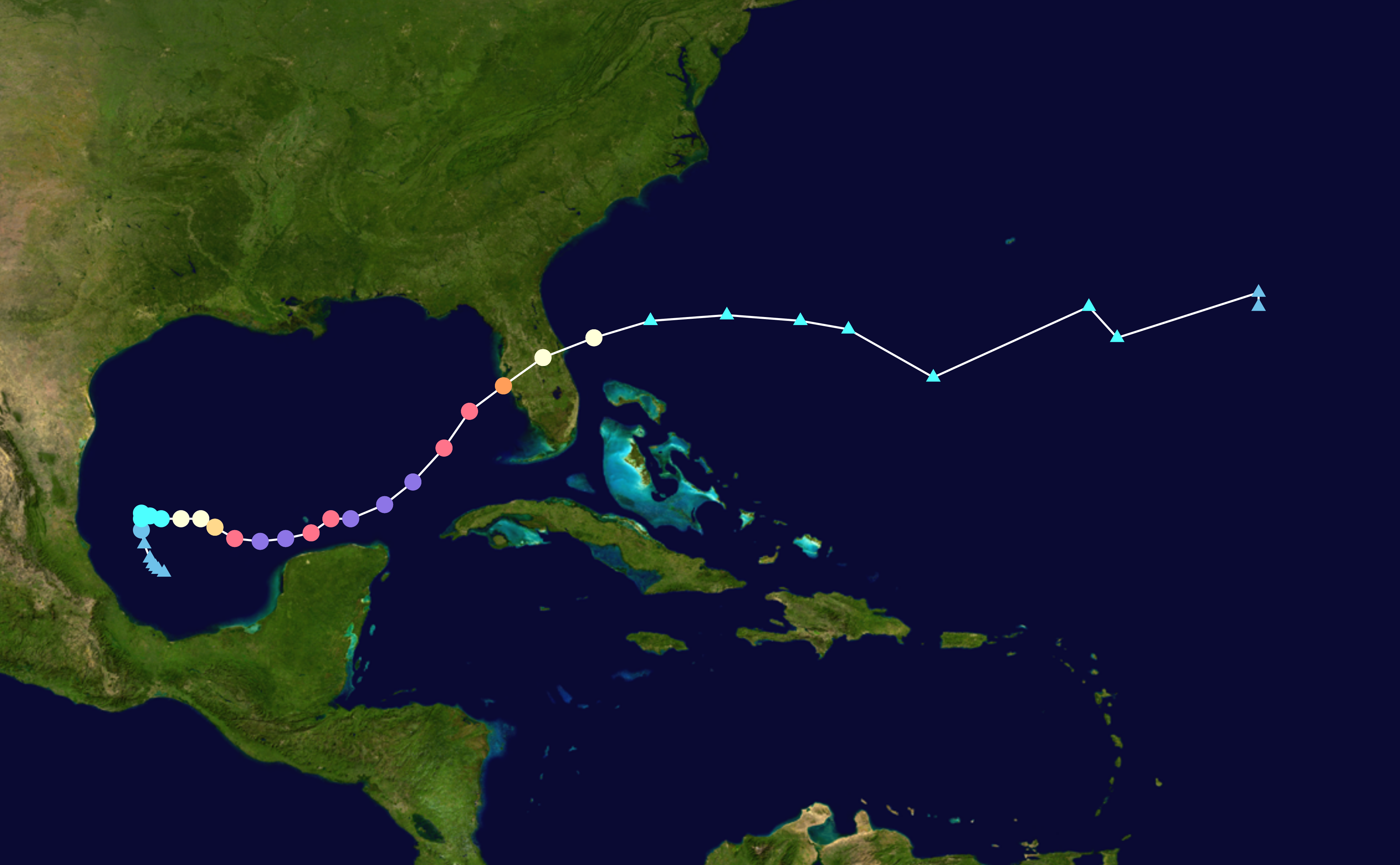
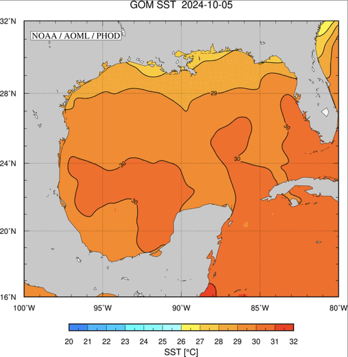
Track and intensity of Hurricane MILTON (left), source:
NASA, and the sea surface temperatures of the Gulf of Mexico, 05.10.2024 (right), source:
AOML NOAA
|
 |
 |
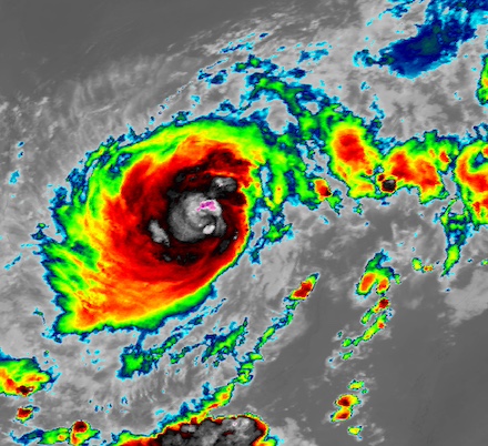
At 00 UTC on October 07, 2024, tropical cyclone MILTON was a category 1 hurricane with sustained winds of 140 kph and a central pressure of 981 hPa. Still located over the Bay of Campeche, the system remained over very warm ocean waters with sea surface temperatures of 30 °C. With weak shear and abundant mid-level moisture, the hurricane was in a very favorable environment for intensification. In the second half of October 07, 2024, Hurricane MILTON underwent an extreme rapid intensification cycle. By 09 UTC, the sustained winds of Hurricane MILTON reached 155 kph with a central pressure of 972 hPa. In the following hours, an explosive intensification followed, at a rate rarely seen over the Atlantic Basin. By 16 UTC, Hurricane MILTON reached category 5 strength. Reconnaissance data revealed that the pressure in the eye of the hurricane dropped to 925 hPa. At the same time, the sustained winds around the eye of the hurricane increased to 260 kph.
|
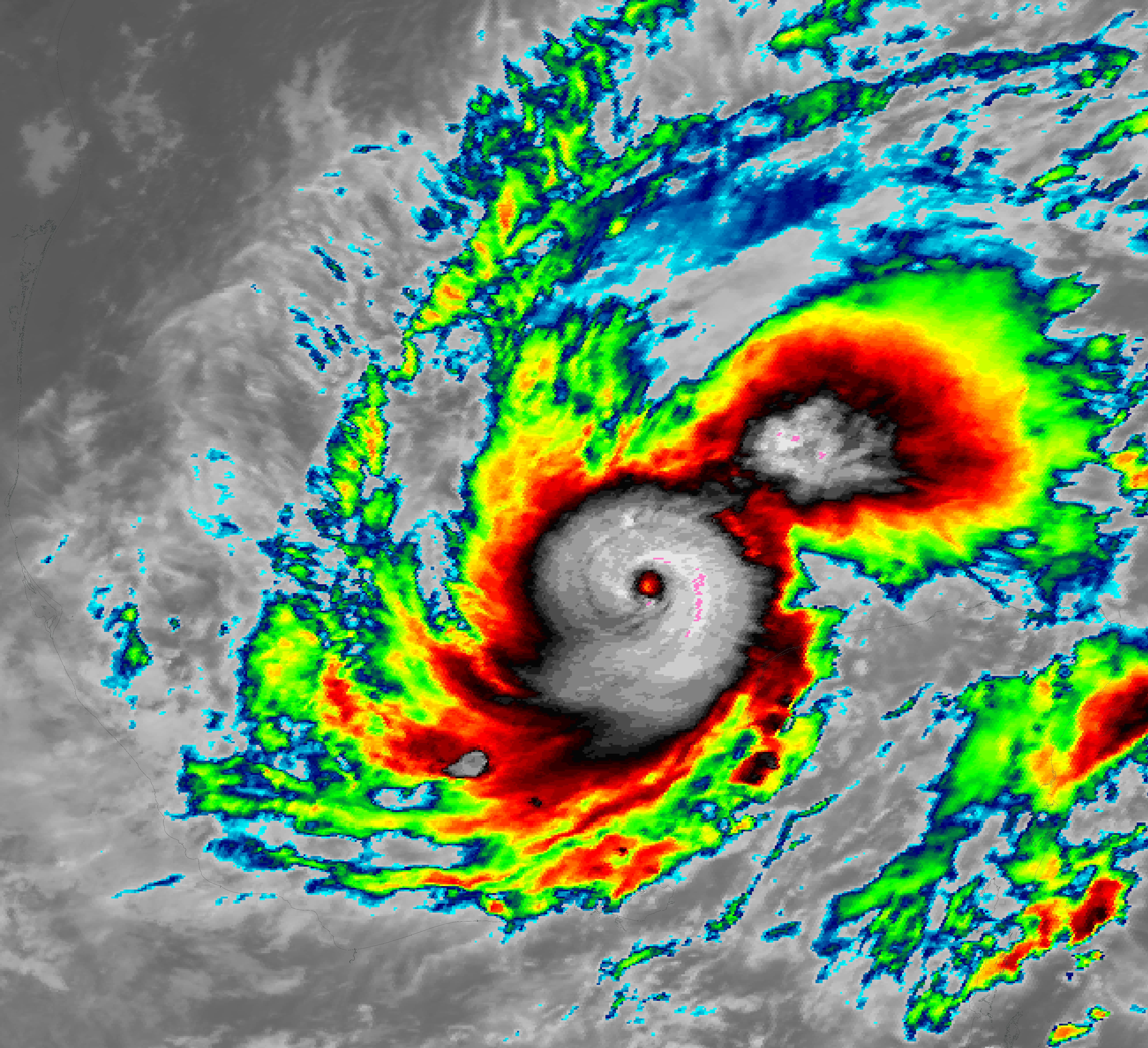
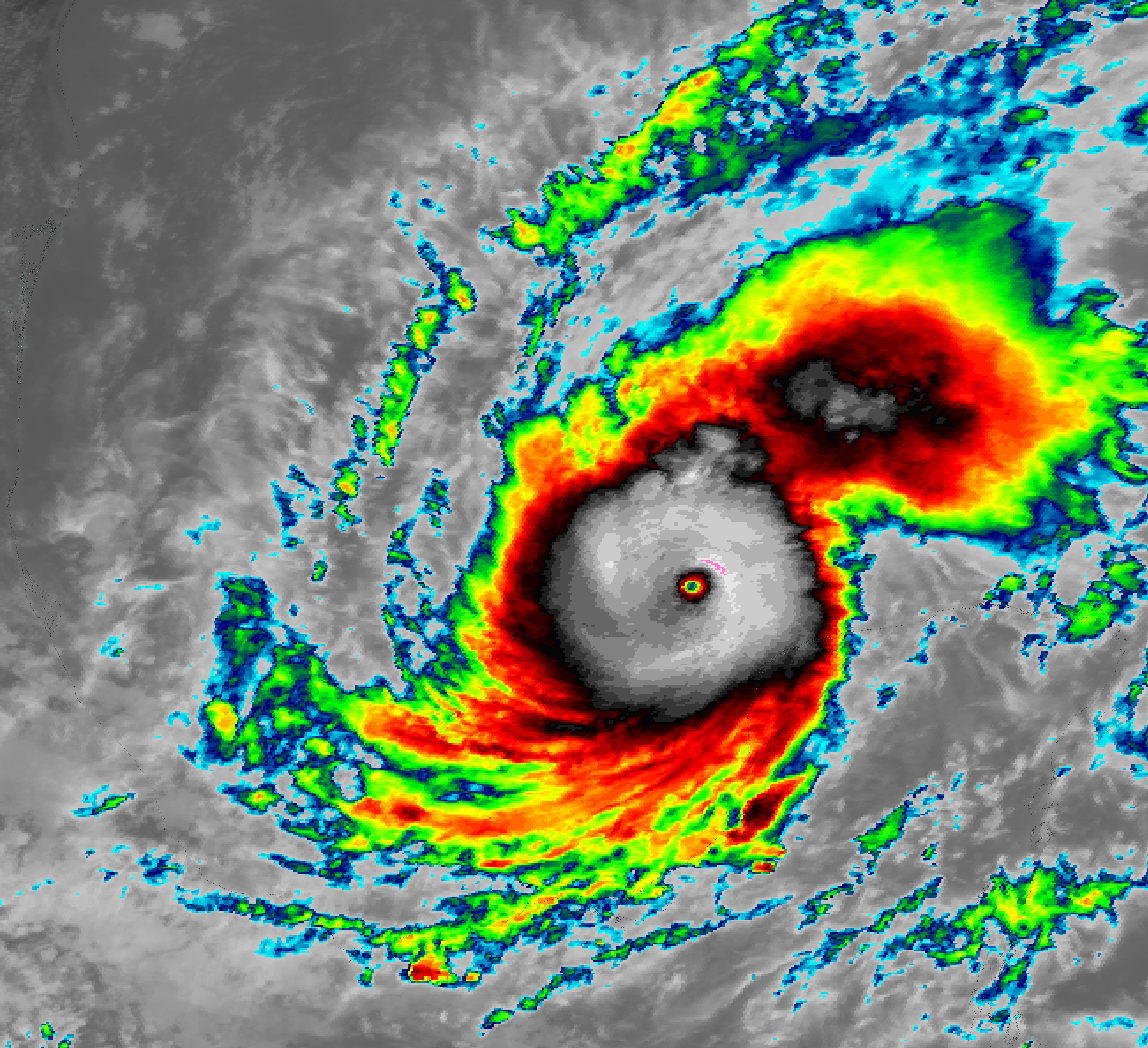
3 hourly infrared satellite imagery of Hurrikcane MILTON over the Bay of Campeche during its rapid intensification cycle, 07.10.2024 09 UTC - 18 UTC, source:
NASA Worldview
|
 |
 |
 |
 |
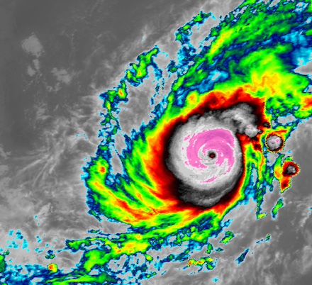
By 00 UTC on October 08, 2024, the rapid intensification cycle of Hurricane MILTON ended. The sustained winds reached 285 kph with the central pressure dropping to 897 hPa. That made Hurricane MILTON the strongest hurricane over the Atlantic Ocean since Hurricane WILMA in October 2005. Hurricane WILMA reached sustained winds of 295 kph and a central pressure of 882 hPa at peak intensity. Over the Atlantic Ocean, there are only five other hurricanes with a recorded central pressure of less than 900 hPa. During its rapid intensification cycle, the sustained winds of Hurricane MILTON increased by 145 kph within a 24 h period. At the same time, the central pressure of Hurricane MILTON decreased by 84 hPa. This extreme case of a rapid intensification cycle is the third strongest ever observed over the Atlantic Ocean after Hurricane WILMA in 2005 and Hurricane FELIX in 2007.
|
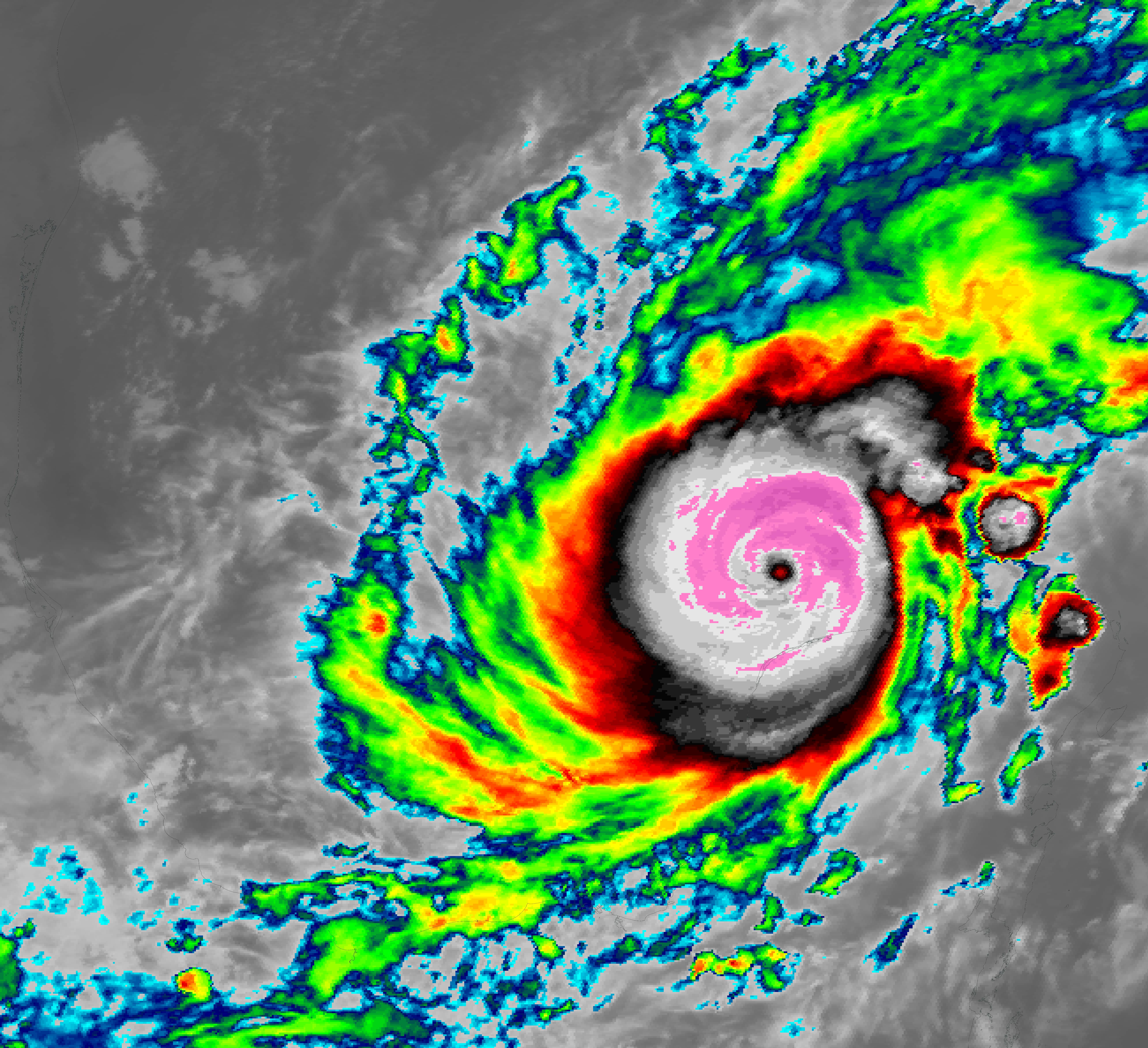
24 h development of Hurricane MILTON over the Bay of Campeche during its rapid intensification from a category 1 hurricane (left), 07.10.2024 00 UTC, to an extremely powerful category 5 hurricane (right), 08.10.2024 00 UTC, source:
NASA Worldview
|
 |
 |
During the rapid intensification of Hurricane MILTON, the size of the hurricane remained remarkably small as it moved across the Bay of Campeche with a diameter of only 300 km. At peak intensity, Hurricane MILTON had a pinhole eye with a diameter of only 6 km. Besides the very small eye, the southeasterly motion vector of Hurricane MILTON has been unprecedented for a category 5 hurricane. Typically, category 5 hurricanes tend to move to the northwest over the Atlantic Ocean. Early on October 08, 2024, Hurricane MILTON neared the Yucatán Peninsula. The hurricane brought high winds, heavy rains, and rough seas. On October 08, 2024, Hurricane MILTON underwent an eyewall replacement cycle. During this process, a second eyewall develops around the primary eyewall. The outer eyewall deprives the inner eyewall of moisture, the energy reservoir of a tropical cyclone. This process eventually leads to the collapse of the inner eyewall. While this process is commencing, the intensity of hurricanes slightly decreases. In the case of Hurricane MILTON, the sustained winds decreased to 230 kph while the central pressure of the cyclone increased to 929 hPa. As a result, Hurricane MILTON was degraded to category 4.
|
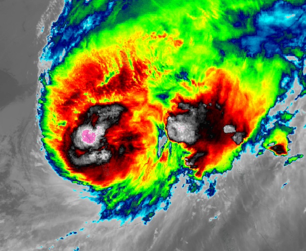
Visible satellite imagery of Hurricane MILTON over the Gulf of Mexico during its second intensification cycle, 08.10.2024 14 UTC (left) and 08.10.2024 22 UTC (right), source:
NASA Worldview
|
 |
 |
In the second half of October 08, 2024, Hurricane MILTON moved ahead of an upper-level trough located over the US. As a result, the hurricane shifted onto a northeasterly trajectory. After the eyewall replacement cycle ended, Hurricane MILTON could intensify once again. At 00 UTC on October 09, 2024, the intensity of Hurricane MILTON reached a second peak with sustained winds of 270 hPa and a central pressure of 902 hPa. The extreme intensity of Hurricane MILTON was related to the favorable environmental conditions. During this intensification process, Hurricane MILTON moved across the very warm waters of the Loop current. Throughout October 09, 2024, Hurricane MILTON moved into an environment with progressively increasing shear. Together with an inflow of drier air masses, the intensity of Hurricane MILTON gradually decreased.
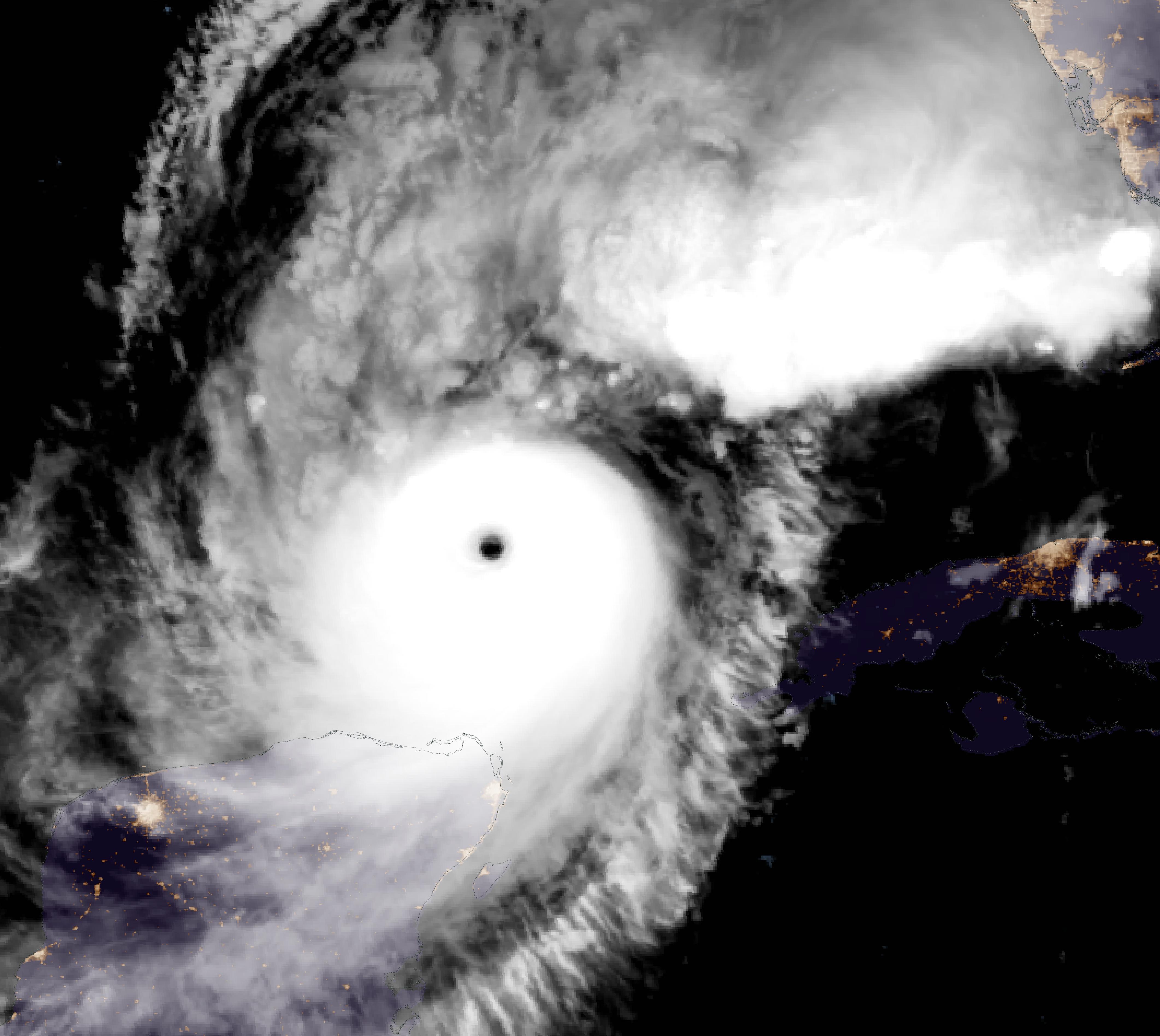
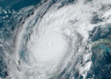
Infrared satellite imagery of Hurricane MILTON over the Floridian Peninsula during landfall, 10.10.2024 00:30 UTC,
source:
NASA Worldview
|
 |
Nearing the Floridian Gulf Coast, the intensity of Hurricane MILTON decreased to category 3. At the same time, the hurricane grew substantially in size. The eye of the hurricane filled with clouds and initial signs of an extratropical transition could be deduced from satellite imagery. Before the inner bands of Hurricane MILTON made landfall in Florida, a severe tornado outbreak occurred over Southern Florida. At least 38 tornadoes have been reported during the passage of Hurricane MILTON. Multiple wide-tunneled EF3 tornadoes moved over the southern part of the state, leading to large damages in the paths of the tornadoes. On October 09, 2024, 126 tornado warnings were issued in the state of Florida. This is the highest daily total of tornado warnings ever issued in Florida. In the entire US, only one other state has seen a higher daily tornado warning total. Interestingly, Oklahoma is not the state in question. Rather, it is Alabama that set the nationwide record at the height of the 2011 Super Outbreak on April 27, 2011.
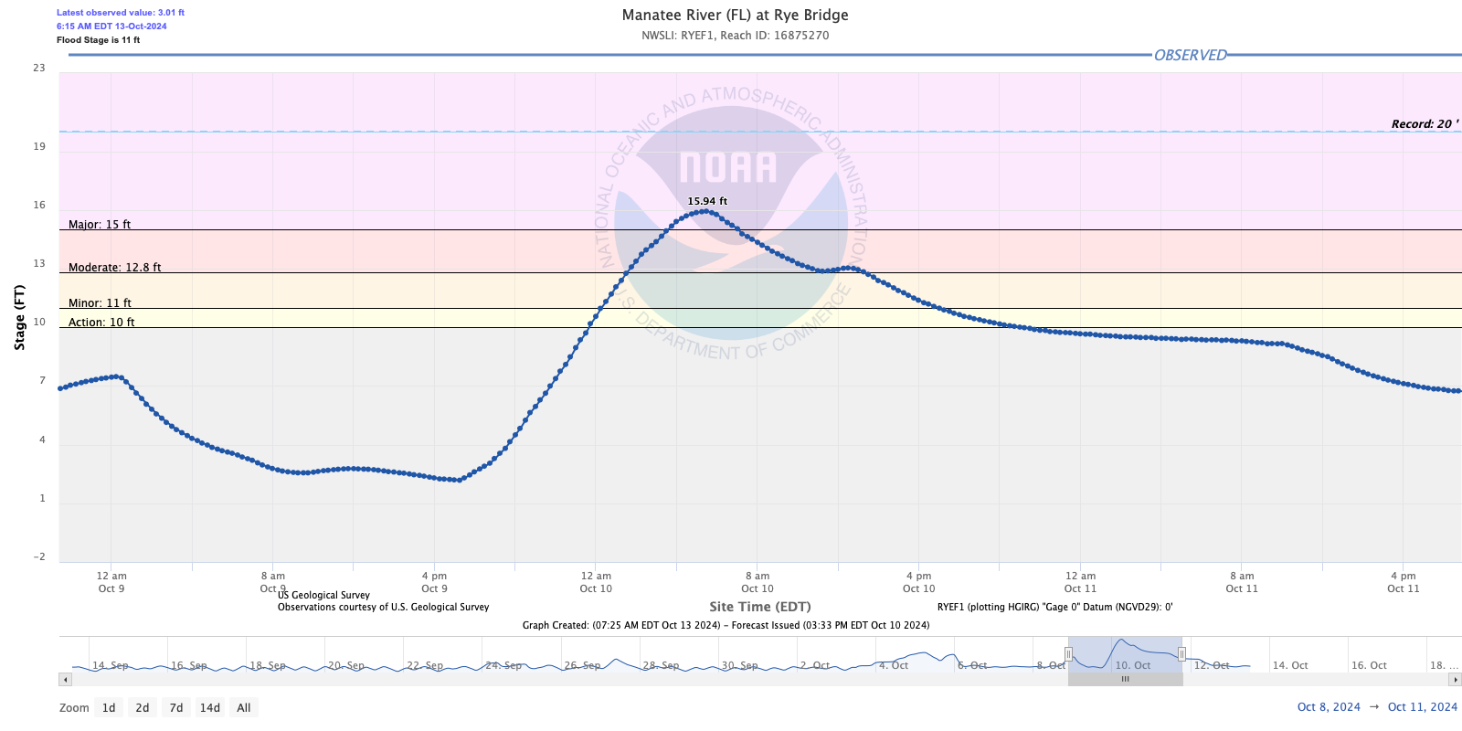
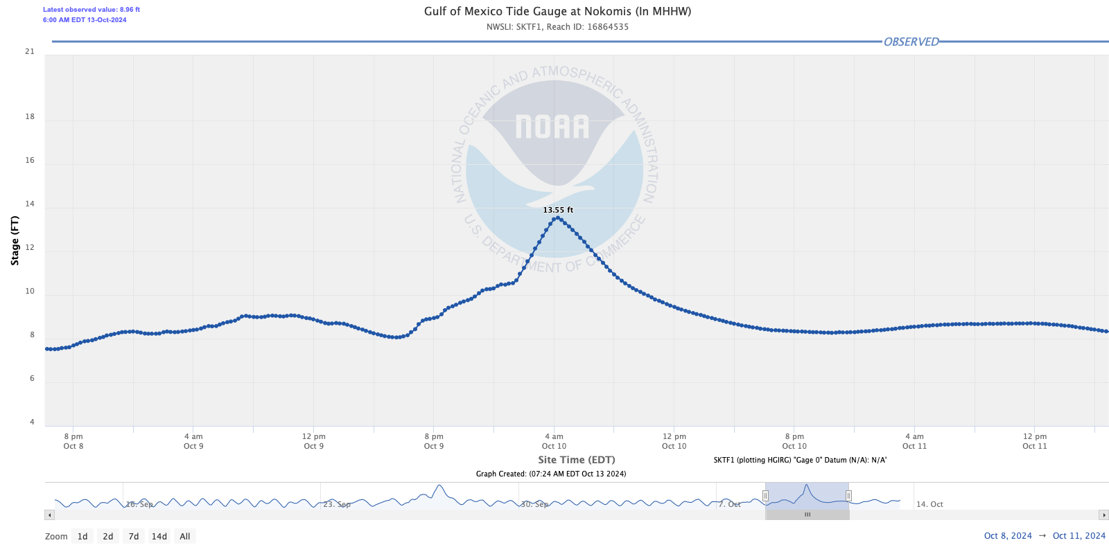
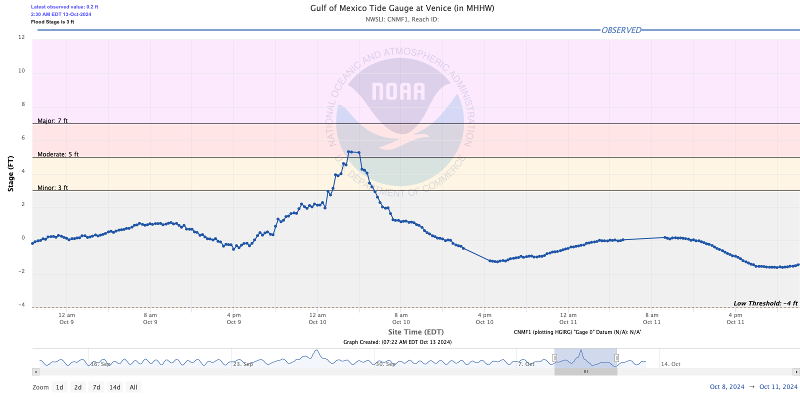
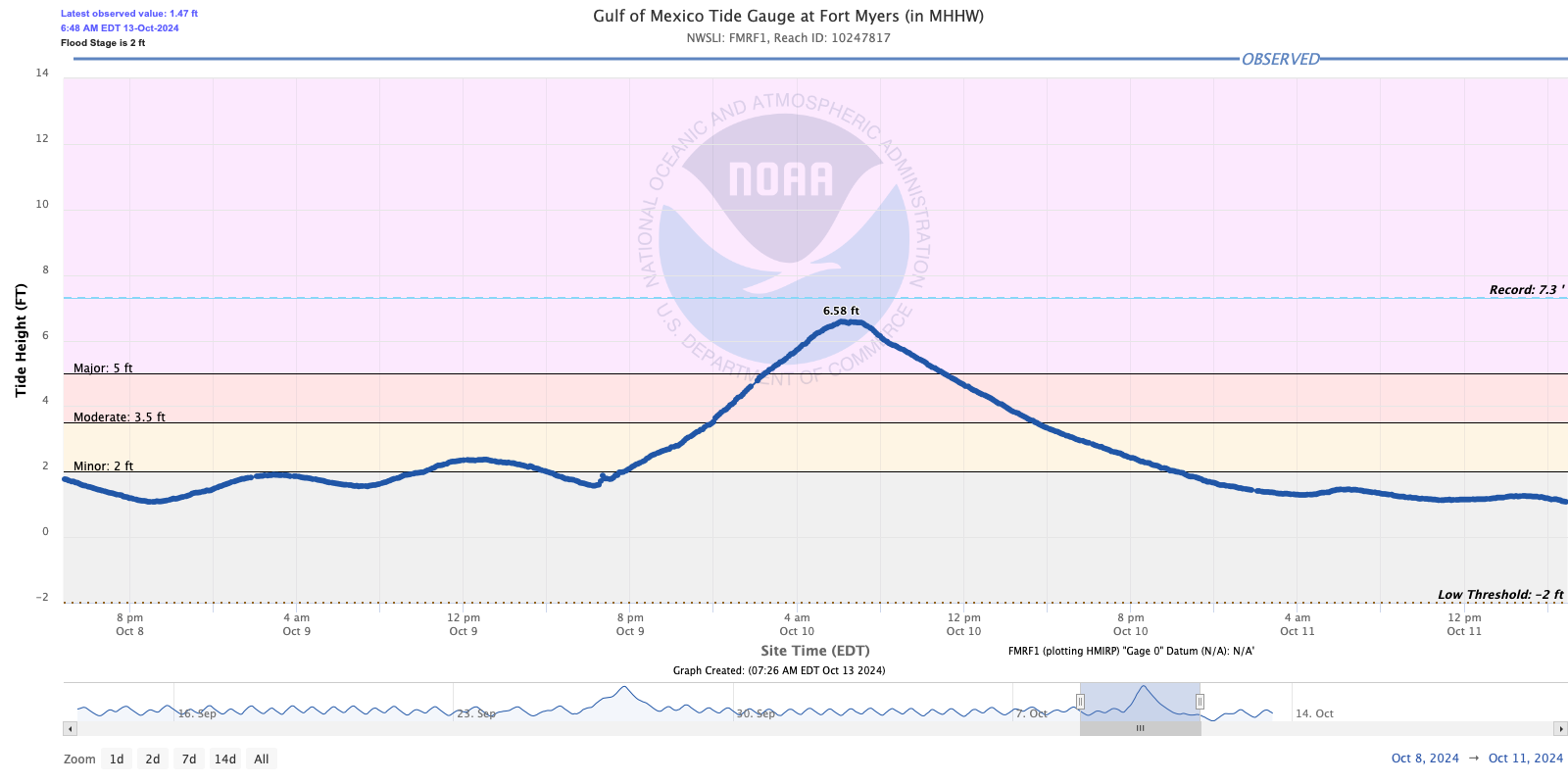
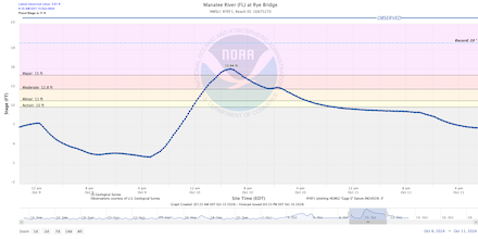
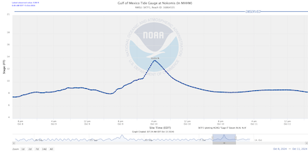
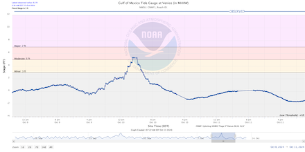
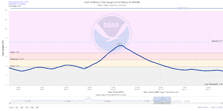
Hurricane MILTON made landfall near Siesta Key, FL at 00:30 UTC on October 10, 2024. Upon landfall, Hurricane MILTON brought torrential rains, violent winds, and severe storm surge. In the last hours before landfall, the track of Hurricane MILTON crucially shifted southwards. This left the Tampa Bay Area to the north of the cyclone center. Thus, the metropolitan area of Tampa took the brunt of the precipitation. However, the offshore winds on the northern side of the storm reduced the storm surge in Tampa Bay significantly. Therefore, the bay was spared from a potentially devastating storm surge. Further south near Sarasota, FL, the storm surge of Hurricane MILTON reached more than 2 m. During the passage of the eyewall, a wind gust of 172 kph was recorded in the city of Sarasota, FL. Coastal communities in the path of Hurricane MILTON were not only impacted by a severe storm surge but also copious sand amounts were pushed onshore. In some communities, sand depths of more than 1 m have been reported.
|
Storm surge of Hurricane MILTON at Rye Bridge, FL along the Manatee River (upper left), Nokomis, FL (upper right), Venice, FL (lower left), and Fort Myers, FL (lower right):
Water NOAA
|
 |
 |
 |
 |
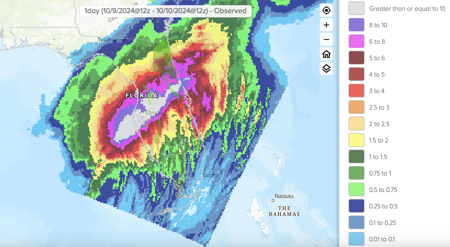
North of the cyclone center, torrential rains impacted the city of Saint Petersburg, FL. The peak 1 h precipitation rate in the city reached a staggering 129.3 mm. Within a 12 h period, the city of Saint Petersburg saw an extreme rain accumulation of 428 mm. Such precipitation rates have a return period of less than once in a millennium. The storm total in Saint Peterburg reached 483.1 mm. In Tampa, FL, the international airport received 300 mm of rain during the passage of Hurricane MILTON. Within a 24 h period, more rain fell in the city than in the wettest October on record. The previous record was set in October 1922 when 264,4 mm of rain fell in the entire month. Unsurprisingly, these torrential rains led to large urban flooding in the Tampa Bay Area. The floods were accompanied by violent winds gusting up to 160 kph. These winds led to widespread damage to multiple high-rise buildings in the metro. The Tropicana Field in Tampa lost large parts of its fiberglass roof due to the violent winds of Hurricane MILTON.
|
Daily precipitation totals of Hurricane MILTON across the Floridian Peninsula, 10.10.2024, source:
Water NOAA
|
 |
South of the cyclone center, Hurricane MILTON brought much less precipitation. However, the onshore winds of Hurricane MILTON exacerbated the storm surge. Near Port Charlotte, FL, the storm surge of Hurricane MILTON reached more than 3 m. This area had already been severely impacted by Hurricane IAN just 2 years ago.
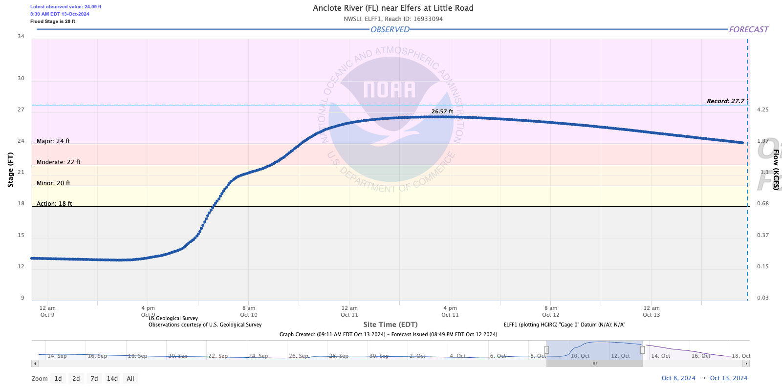
Moving across the Floridian Peninsula, Hurricane MILTON weakened. Nevertheless, hurricane-force winds were also observed along the Atlantic Coast of Florida. At Daytona Beach, FL, wind gusts reached 140 kph. Precipitation totals of more than 200 mm were observed in parts of Central Florida, stretching from Tampa in the west over Orlando to Daytona Beach in the east. The heavy rains led to widespread flash and urban flooding. In the central part of Florida, the torrential rains also caused extreme river flooding. Some rivers crested at record-breaking levels. Stretching from Saint Petersburg into the central part of the peninsula, the average return period of these rains reached 200 to 500 years. Even on the Atlantic Coast near Titusville, FL, the rains surpassed the 100-year return period. By 09 UTC on October 10, 2024, Hurricane MILTON moved off-shore north of Cape Canaveral, FL. Over the Atlantic Ocean, the hurricane moved eastwards retaining hurricane strength as the extratropical transition of the system continued. By 18 UTC, the National Hurricane Center (NHC) classified the cyclone as extratropical. In the following two days, the extratropical low slowly dissipated as it moved south of the Bermudas into the Subtropical Atlantic.
|
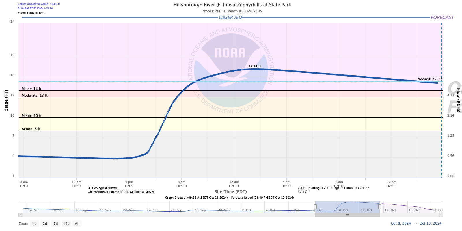
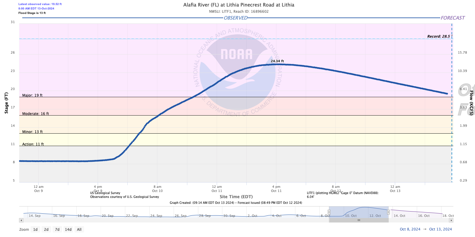
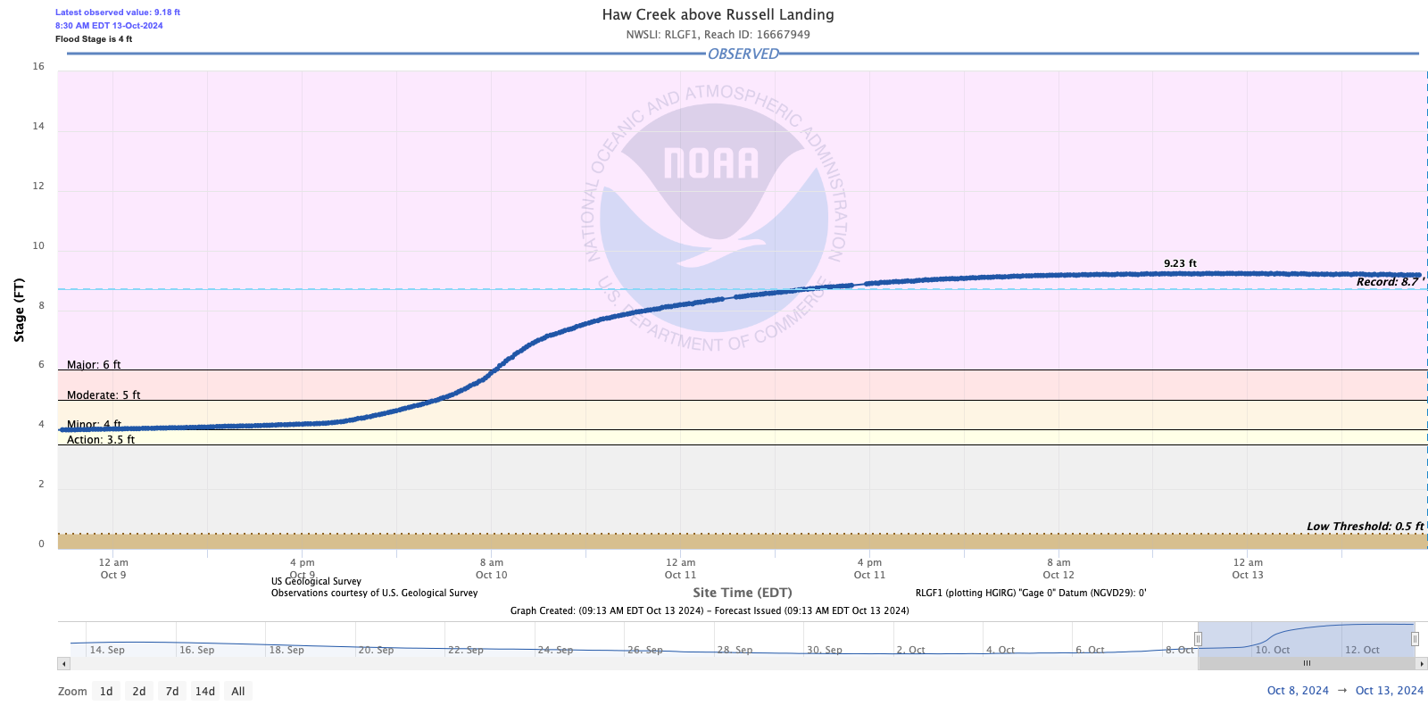
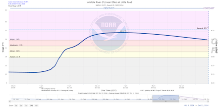
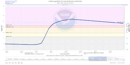
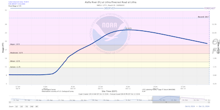
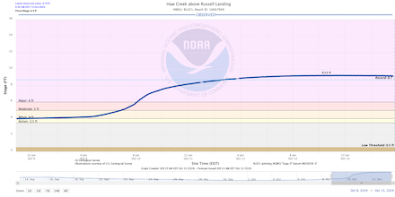
Extreme river flooding following the passage of Hurricane MILTON across the central part of the Floridian Peninsula observed at Anclote River near Elfers, FL (upper left), Hillsborough River near Zephyrhills, FL (upper right), Alafia River at Lithia, FL (lower left), and Haw Creek above Russell Landing, FL (lower right):
Water NOAA
|
 |
 |
 |
 |
Within 14 days, two major hurricanes have made landfall along the Floridian Gulf Coast. Before the landfall of Hurricane MILTON, it was feared that the hurricane might move further north, where Hurricane HELENE had larger impacts. Moreover, the devastating damages due to Hurricane HELENE in the southern Appalachians and ongoing rescue missions kept many forces occupied. Only three other hurricane seasons had five landfalling hurricanes along the US Gulf Coast. The only season with six landfalling hurricanes along the US Gulf Coast dates back to 1886. With the landfalls of Hurricanes DEBBY, HELENE, and MILTON along the Floridian Gulf Coast, the 2024 Hurricane Season was the tied busiest season on record in Florida with 1871, 1886, 1964, 2004, and 2005. Since Hurricane IAN made landfall in September 2022, 4 major hurricanes made landfall in Florida in the past 25 months. Due to the recent tropical activity, the 2024 Atlantic Hurricane Season was pushed above the long-term average for all important quantities. This comes after a record-breaking lull in the Atlantic Basin during most of August and early September.
Currently, at least 26 fatalities are related to Hurricane MILTON. More than 3 million customers in Florida were without power as the hurricane moved across the state. Early estimates assessing the damages due to Hurricane MILTON in Florida reckon that the costs of this hurricane amount to at least 30 billion $. This makes Hurricane MILTON the ninth costliest US hurricane, tied with Hurricane Ike of 2008 (not adjusted for inflation). From a meteorological standpoint, it must be highlighted that the landfalling point of Hurricane MILTON was within 20 km of the initial 5-day track guidance of the NHC.
Text: KG
October 13, 2024
|