|
|
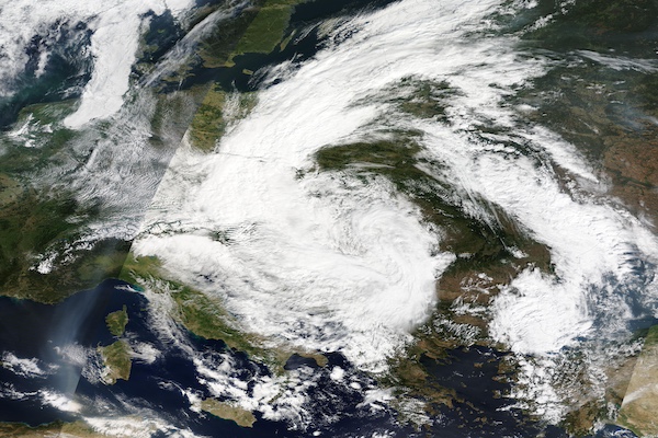
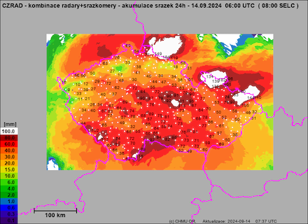
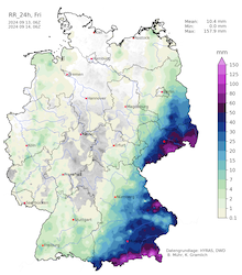
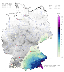
A detailed analysis reveals two periods of extreme precipitation. On September 13 and September 14, 2024, extreme precipitation totals were observed in Eastern Germany, Czechia, Poland, and Austria. In parts of Lower Austria and the Sudetes, 48 h precipitation totals of more than 300 mm were measured. On September 14, 2024, the worst daily precipitation of low Anett was observed. Widespread precipitation totals far exceeded 100 mm. In the area around Sankt Pölten, AT, and the Sudetes, daily precipitation totals of more than 200 mm were reported. In the Beskids, CZ, a staggering 238.5 mm of rain were observed in a 24 h period. The measuring gauge is located at the top of the 1323 m high Lysá hora mountain.
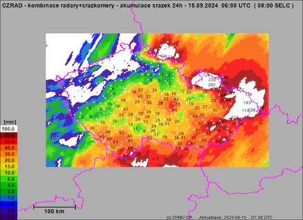
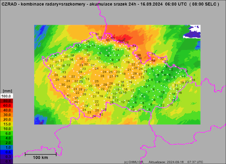
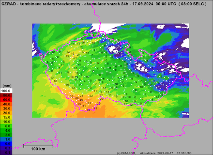
| Daily precipitation totals over Czechia, 13.09.2024 - 16.09.2024, source: Czech Hydrometeorological Institute | |||
 |
 |
||
 |
 |
||
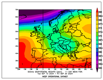
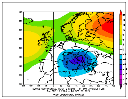
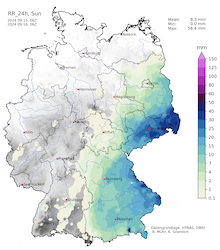
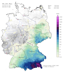
On September 15, 2024, the daily precipitation totals were much lower. Still, continuous rains were falling across Central Europe. The highest daily precipitation total was observed at Lilienberg-Tarschberg in Lower Austria with 74.8 mm. On the following day, September 16, 2024, low Anett started to move southwestwards as the expanding ridge north of the cut-off low forced the system back south. Along the Northern Alps, widespread daily precipitation totals of more than 50 mm were reported from Lower Austria to Bavaria. Early on September 17, 2024, the rains of low Anett finally subsided over Austria, Czechia, and Poland. Since the onset of the rains, precipitation totals of more than 400 mm were reported from Lower Austria. The measuring sites at Sankt Pölten, Langenlebarn, and Lilienberg-Tarschberg all reached accumulations of more than 400 mm. Especially at the first two measuring sites, these precipitation totals are highly remarkable. Because the lower Danube Plain only sees annual precipitation totals of around 700 mm.
| Daily precipitation totals over Germany, 13.09.2024 - 16.09.2024, source: Wettergefahren Frühwarnung | |||
 |
 |
 |
 |
On its southwesterly trajectory from Eastern Europe into the Mediterranean, low Anett also brought heavy rains to Italy. On September 18 and September 19, 2024, precipitation totals of 200 mm/48 h were measured. Heavy rains impacted the Emilia-Romagna region in Northern Italy. The highest precipitation totals were measured in the area around Bologna.
| Total accumulated precipitation, 11.09.2024 06 UTC - 16.09.2024 06 UTC, river levels, and flooded areas in Eastern Central Europe, source: ERCC | |||
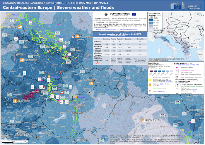 |
|||
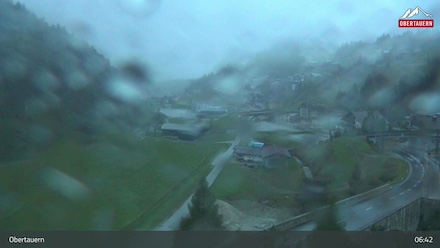
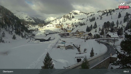
Aside from the extreme precipitation totals, the cold airmass residing over Central Europe led to substantial fresh snow accumulations in the Alps. Along the Northern Alps, the snowline often fell to 1000 m or below. Above 1500 m, fresh snow accumulations of more than 100 cm were measured. The 2320 m high Rudolfshütte located in the Tauern Mountains reported a snow depth of 145 cm on September 17, 2024. This is the largest snowpack ever observed below 2400 m elevation in September in Austria. Throughout the Northern Alps, many areas recorded the worst snowfalls for September in decades. The largest fresh snow accumulations related to low Anett were reported from the Dachstein and Tauern Mountains in Austria. The highest mountains of the Bohemian Forest even saw their first measurable snowfall for the winter season 2024/25.
| At Obertauern in the Tauern Mountains, low Anett brought large snow accumulations. At the beginning of the storm, there is no snow on the ground, 12.09.2024 04:45 UTC (left), and after the storm, the town is buried in a deep snowpack, 17.09.2024 06:45 UTC (right), source: Feratel | |||
 |
 |
||
The heavy precipitation and snowfall also led to an extreme cold wave for the second decade of September. In South Tyrol, hikers were trapped by an early-season blizzard on September 10, 2024. On September 13, 2024, Vienna recorded a daily maximum temperature of only 8 °C. In contrast, the first decade of September here was dominated by extreme heat for the season. Only 5 days prior, a daily maximum temperature of more than 30 °C was recorded in the city.
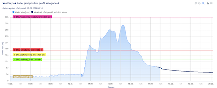
Due to the extreme precipitation in parts of Eastern Germany, Czechia, Poland, and Austria, severe to catastrophic river flooding was observed along all rivers draining the affected areas. Many minor rivers draining Lower Austria, and the Sudetes Mountains flooded to an extreme degree during the catastrophic rains of September 13 and September 14, 2024.
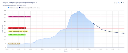
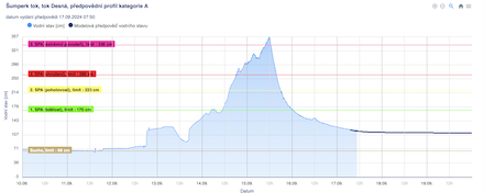
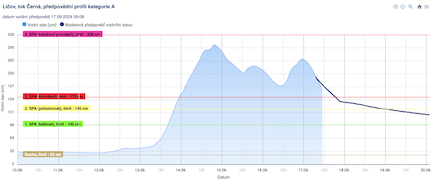
| Extreme flooding measured at different measuring gauges throughout the Czech Republic. At Vestrev in the Giant Mountains, the Elbe River reached record-breaking water levels of 354 cm, beating the previous record from 2013 by 61 cm (top left). The Opava River at Dehylov (top right) and the Desná River at Sumperk (lower left) also recorded extreme flooding. Minor rivers draining the Bohemian Forest reached also severe flooding stages, as seen at the measuring gauge of the Cerná River at Licov (lower right), source: Czech Hydrometeorological Institute | |||
 |
 |
||
 |
 |
||
Even at the edges of main precipitation areas, severe river flooding was monitored along the minor rivers draining the Bohemian Forest. In Austria, many minor rivers flooded severely in this period. The worst flooding was observed in the area between Sankt Pölten and Vienna. Here, many smaller rivers turned into raging streams. The Perschling at Böheimkirchen near Sankt Pölten reached a peak discharge of 270 m³/s. As a reference, a 100-year flood has a discharge of only 108 m³/s at this measuring gauge. At Vienna, the Wien River flooded also severely, surpassing the 100-year flood marks throughout the city.
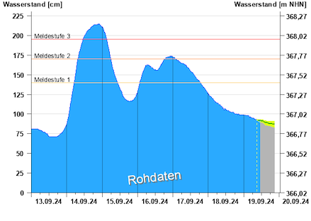
| Severe flooding at the Cham River at Regen, BY draining the Bavarian Forest (left) and severe flooding at the Danube River at Passau-Ilzstadt, BY (right), source: HND Bayern | |||
 |
 |
||
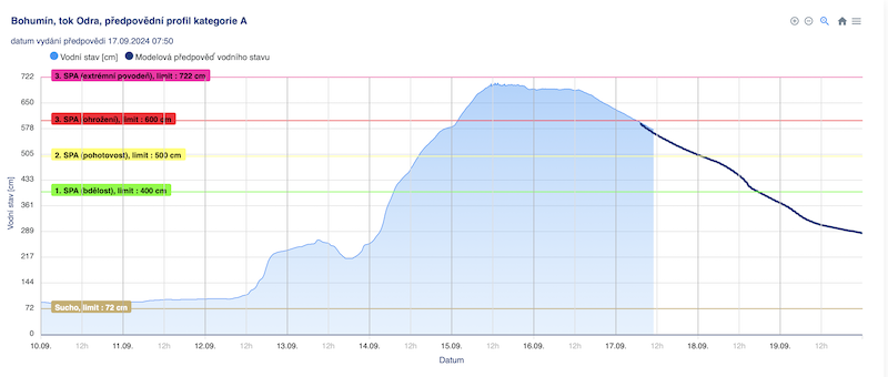
The river flooding quickly shifted from the minor rivers into major rivers draining the affected areas. Because the rains on September 16, 2024, were far less severe. Along the Danube, Elbe, and Oder Rivers a major flood quickly developed. At Vienna, the peak discharge of the Danube River remained only 100 m³/s below the 100-year flood threshold. However, this data is only preliminary. With a peak discharge of 10,300 m³/s, the flood of the Danube River at Korneuburg, AT was at a similar magnitude to the flood in August 2002.
| Severe flooding at the upper part of the Oder River at Bohumin in the Sudetes. With a peak river level of 660 cm, the flood remained 43 cm below the record peak of the flood of 1997, source: Czech Hydrometeorological Institute | |||
 |
|||
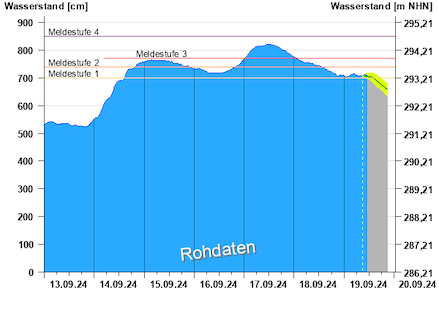
At the Elbe River, severe river flooding was reported in the upper part of the river in the Giant Mountains. However, further downstream, the crest of the river flood shallowed. Past the German-Czech border in the Ore Mountains, no severe river flooding was measured. In Dresden, the flood of the Elbe River was less severe than initially expected by the authorities. This was a relief for the city of Dresden as on September 11, 2024, a large part of the Carola Bridge collapsed into the Elbe River. The authorities feared that a large part of the collapsed bridge could come loose. Or even worse, additional parts of the bridge could collapse during the flood of the Elbe River. As a response, the bridge was quickly torn down before the crest of the flood of the Elbe River reached the city.
| Severe flooding at the Elbe River at German-Czech border in the Ore Mountains at Schöna, SN (left) and a much shallower flood at Torgau, SN downstream of Dresden, SN (right), source: Landeshochwasserzentrum Sachsen | |||
 |
 |
||
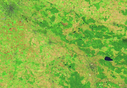
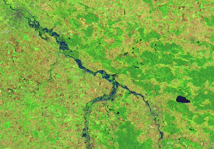
The Oder River also reached critical flooding stages, due to the extreme precipitation totals in the High Ash Mountains and Beskides Mountains in the Sudetes. A severe flood started to spread downstream along the Oder River into Western Poland. Many towns along the Oder River were affected by severe flooding.
| Severe flooding of the Oder River in Poland between Opole and Breslau observed from space, comparing the river level of the Oder River before the onset of the rains of low Anett on 04.09.2024 (left) and after the rains of low Anett on 20.09.2024 (right), source: NASA Earthobservatory | |||
 |
 |
||
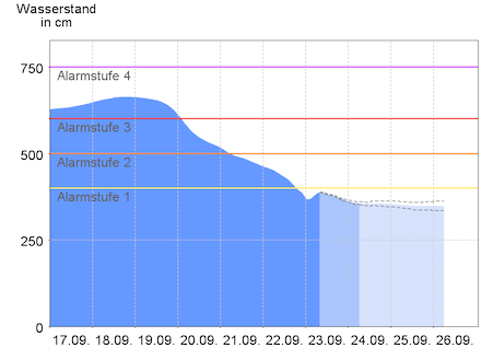
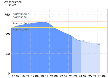
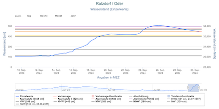
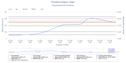
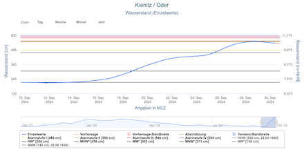
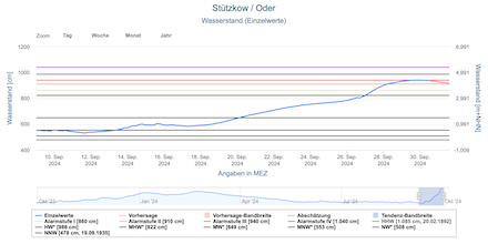
In the second half of September, the flood along the Oder River shifted downstream. At the German-Polish border, the Oder River crested at Ratzdorf, BB on September 25, 2024. The flood crested above the 6 m mark, reaching the extreme flooding stage. Nevertheless, the water levels remained nearly 90 cm below the crest of the catastrophic Oder flood in 1997. In the northern part of Brandenburg, the Oder River crested on September 30, 2024, at the measuring gauge at Stützkow. Further downstream, the crest of the Oder River remained below major flooding marks.
| Development of the river flood along the Oder River in Brandenburg showing that the flood grew more shallow as the crest of the flood moved downstream. As seen in measurements of the measuring gauges at Ratzdorf, BB (upper left), Frankfurt (Oder), BB (upper right), Kienitz, BB (lower left), and Stützkow, BB (lower right), source: Pegelportal Brandenburg | |||
 |
 |
||
 |
 |
||
In the Emilia Romagna region in Northern Italy, heavy rains on September 18 and September 19, 2024, led to widespread flash and river flooding. This damaged many fields and roadways. However, the flooding in this area was less severe than during the severe flooding event of May 2023.
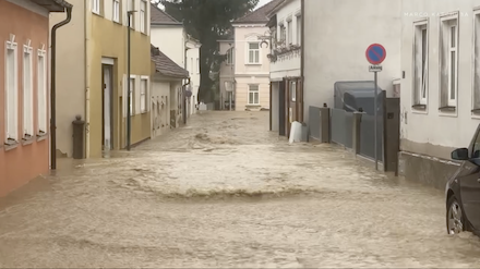
In Austria, Czechia, and Poland, the critical river flooding tested many flood protection systems. Along the Danube and Oder River, many dikes had to be reinforced while some dikes broke. Military forces assisted civilian forces to rescue and minimize damages in the affected areas. Nevertheless, the Oder flood in Poland was less severe than during the catastrophic floods of August 1997. Along the Danube River, many streets and railway lines were damaged. In Prague and Vienna, parts of the subway system were submerged by the river floods. Along the Danube River, extensive damages were reported from the railway lines connecting Vienna and Salzburg. Especially the part between Vienna and Sankt Pölten was severely damaged. At the moment, no official estimate for the reopening of the railway line has been announced.
| Pictures highlighting the severity of the flooding in Lower Austria at Sankt Pölten (left) and Böheimkirchen (right), 15.09.2024 , source: Marco Kaschuba | |||
 |
 |
||
Currently, at least 28 fatalities have been reported by the affected countries by the torrential rains of low Anett. First insurance company estimates suggest that the financial losses in Central Europe will exceed 2 billion €. However, much higher damages are likely to be reported in the future. This makes Low Anett already the third natural disaster in Central Europe. 2024 has been a remarkably wet year in Central Europe. Even though the summer of 2024 had no significant precipitation deviation, many areas still have a large precipitation surplus this year. Furthermore, the recent flooding event is already the third severe river flooding event this year. In 2024, a serious flood occurred along the Saar River in May and in June another record-breaking flood impacted the Danube River and its feeders in Bavaria. Due to the extreme precipitation by low Anett, Austria has recorded the wettest September on record.
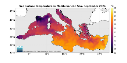
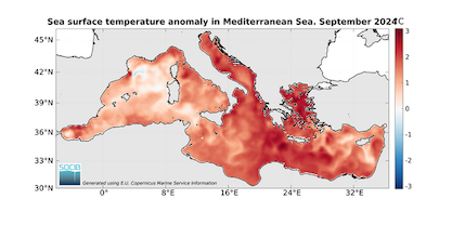
| Monthly-averaged sea surface temperatures of the Mediterranean for September 2024 (left) and monthly-averaged sea surface temperature deviations of the Mediterranean for September 2024 (right), source: SOCIB | |||
 |
 |
||
The marine heatwave in the Mediterranean could have had an impact on the recent floods. After the summer, the water temperatures of the Mediterranean reached more than 28 °C. It seems like a feasible scenario that the combination of a very warm Mediterranean and a warmer atmosphere could have led to increased precipitation totals in the affected areas because of Clausius-Clapeyron scaling. However, it should be noted that extreme precipitation events have been observed in past decades, though this event had been particularly extreme. Whether or to which extent, a warming climate has impacted this event cannot be deduced easily. It should prove to be an interesting research question.
Text: KG
October 02, 2024


