|
A Vb-low brought abundant precipitation over Southern Germany from May 31, 2024, to June 03, 2024. The long-duration continuous precipitation brought a large area stretching from the Swabian Jura to the Alpine Foothills mostly south of the Danube River widespread precipitation totals of more than 150 mm. Along minor rivers feeding into the Upper Danube River, 100-year flood marks were surpassed.
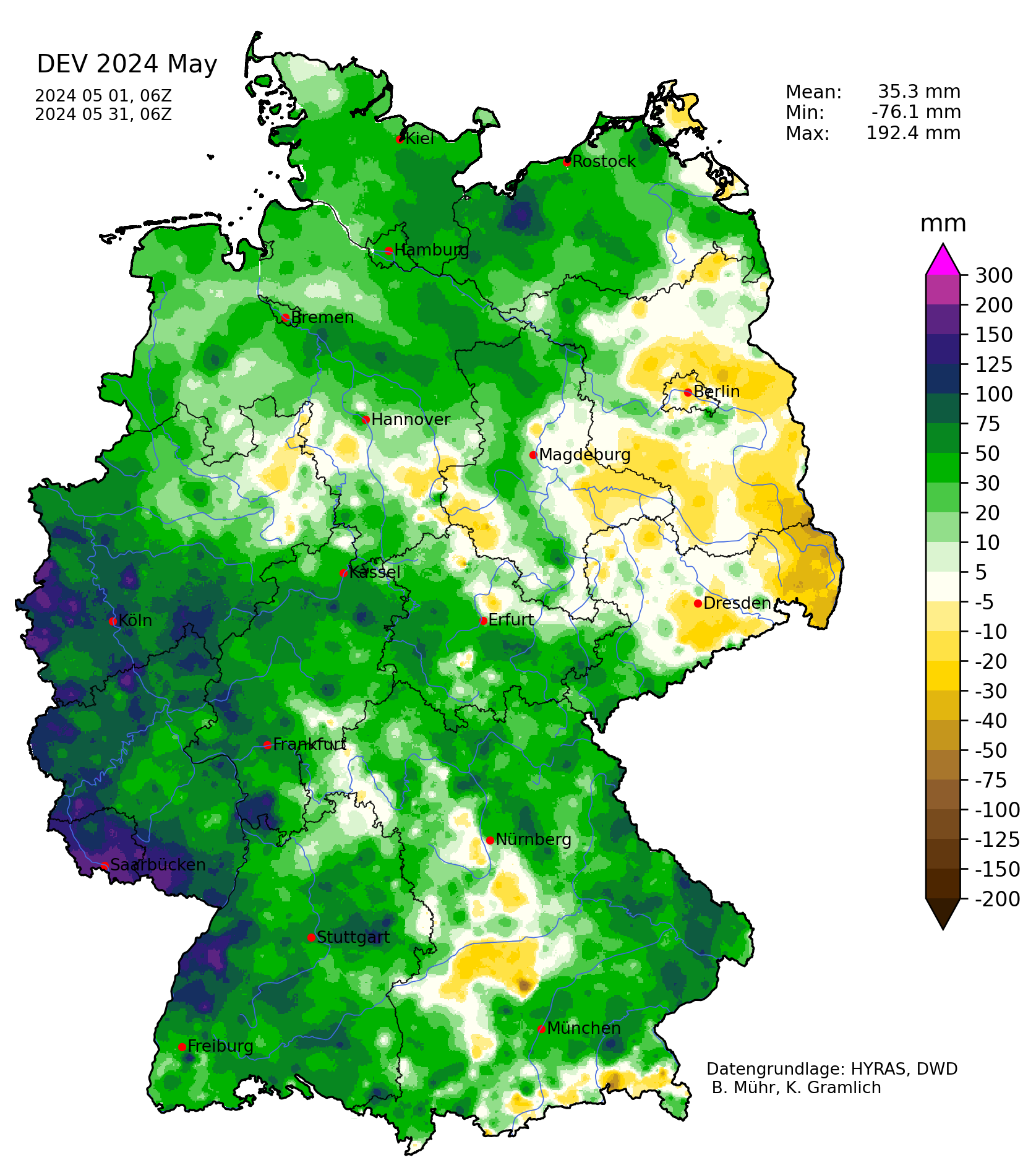
The year 2024 already brought two severe flooding events in Germany. Shortly after New Year, severe river flooding affected Lower Saxony along the Weser River basin. In May, severe river flooding was observed in the state of Saarland and the neighboring Palatine region, here the Saar River basin was affected by severe flooding. Not only the western part of Germany but also many regions in Southern Germany saw above-average precipitation in May, though the deviations before the precipitation event were much smaller.
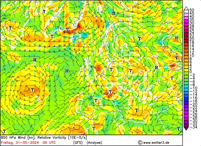
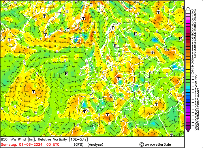
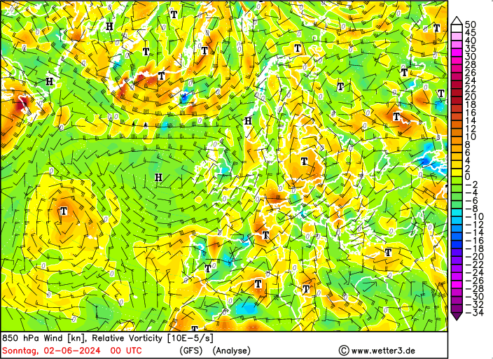
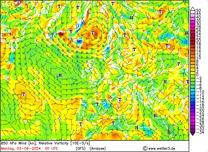
On May 29, 2024, a trough stalled over the North Sea. On the following day, May 30, 2024, the trough over the North Sea induced a lee-cyclogenesis over the Gulf of Genoa. Characteristic for such a lee-cyclogenesis is a Mistral event at the mouth of the Rhone River in Southern France. On May 30, 2024, and May 31, 2024, strong northwesterly winds were observed at the delta of the Rhone River with wind gusts of more than 80 kph. From here, the surface low moved slowly over the Po Plain and crossed the Alps moving into Southern Germany. By June 01, 2024, the low had moved into Poland. This trajectory of the surface low is typical for a Vb-low.
|
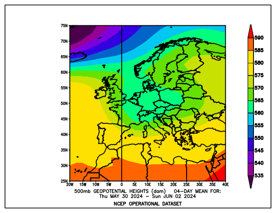
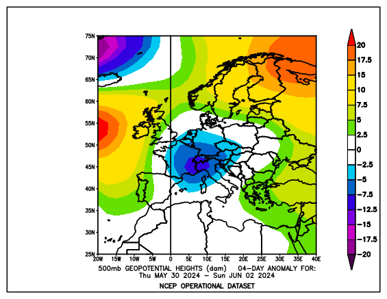
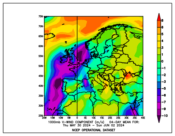
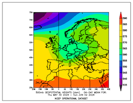
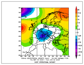
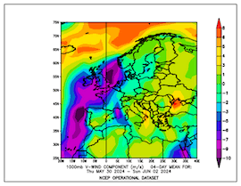
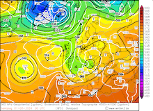
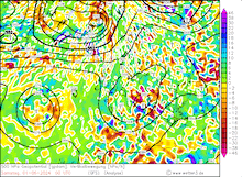
500 hPa geopotential mean (left) and anomaly (middle) and average meridional wind (right) over Europe, 30.05.2024 - 02.06.2024, source:
PSL NOAA
|
 |
 |
 |
Although the pressure gradients were very low, the induced circulation allows warm and moist air masses from the Mediterranean to flow around the low-pressure system over Eastern Europe and into Germany. This makes the area of the highest precipitation totals very sensitive to small changes in the trajectory of the low-pressure system. The abundant mid-level lifting induced by the trough over Germany provided a favorable environment for heavy continuous precipitation. Further, the moist and warm air masses that get advected around the pressure center were unstable and combined with the mid-level lifting induced by the trough allowed the entrainment of convective precipitation cells into the precipitation band.
|
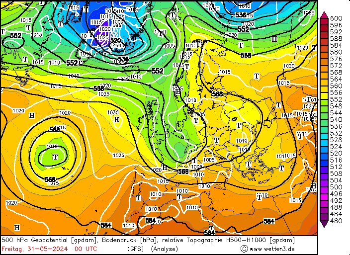
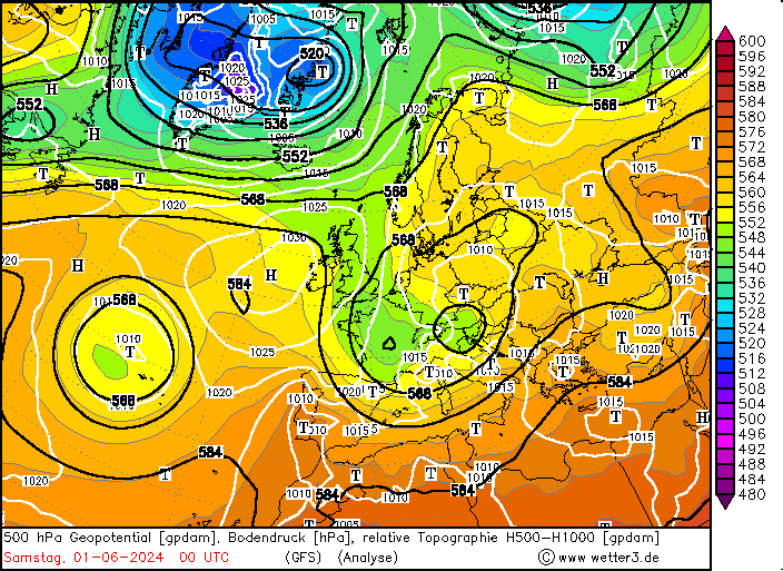
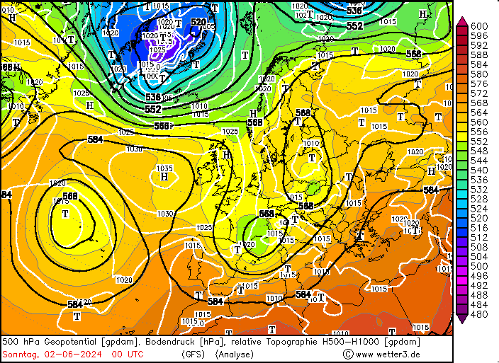
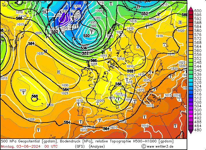
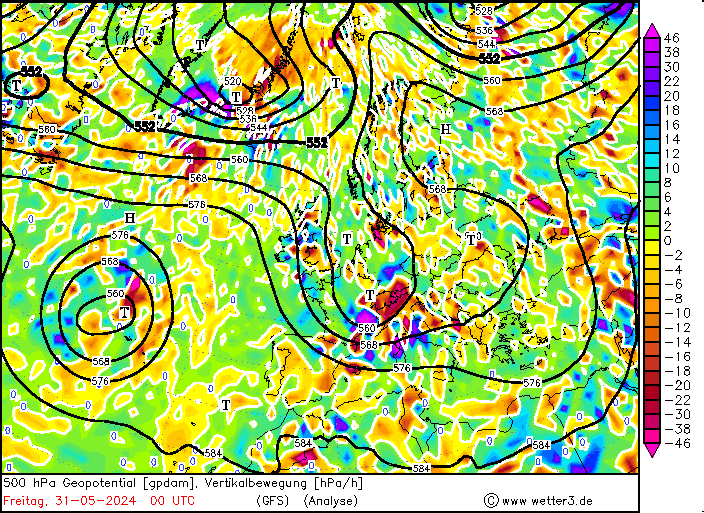
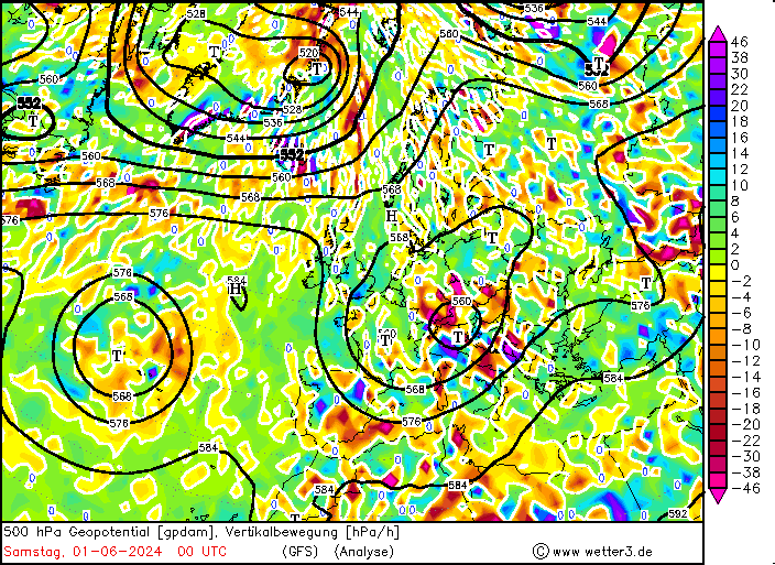
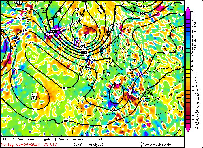
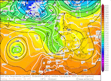
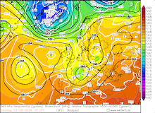
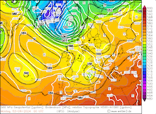
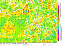
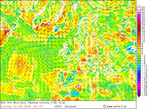
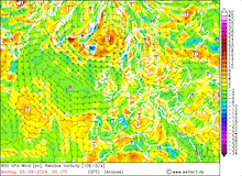
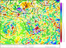
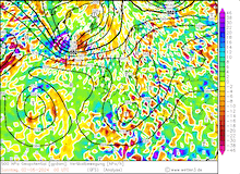
500 hPa geopotential, 1000 hPa to 500 hPa thickness, and sea-surface pressure (upper row), 850 hPa wind and relative vorticity (middle row), and 500 hPa geopotential and vertical velocity (lower row) over Europe, 31.05.2024 00 UTC - 03.06.2024 00 UTC, source:
wetter3.de
|
 |
 |
 |
 |
 |
 |
 |
 |
 |
 |
 |
 |
On May 30, 2024, the trough already induced severe convective activity over Southern Germany with local downpours. A long-lived supercell brought more than 30 mm of rain to a strip just north of the Northern Alps in Bavaria, which saturated the upper-most soil layer in the area where the worst flooding would be observed in the following days.
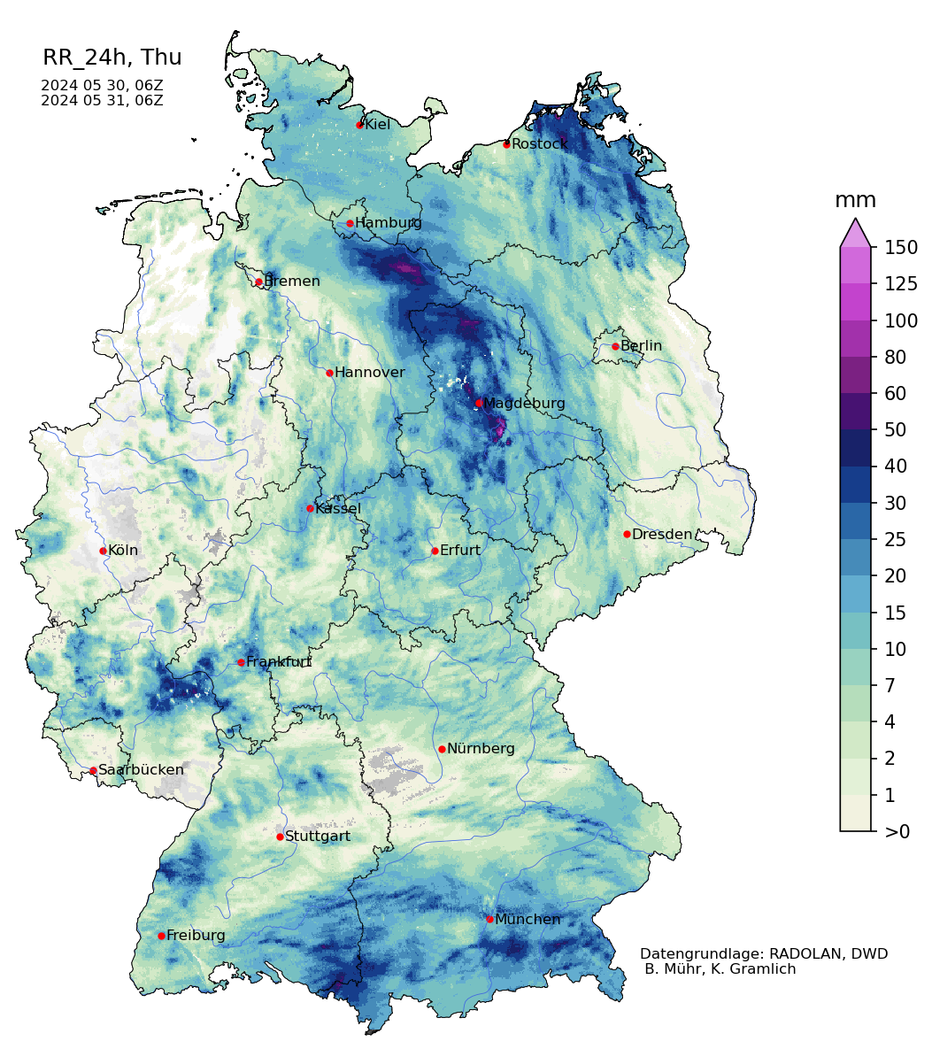
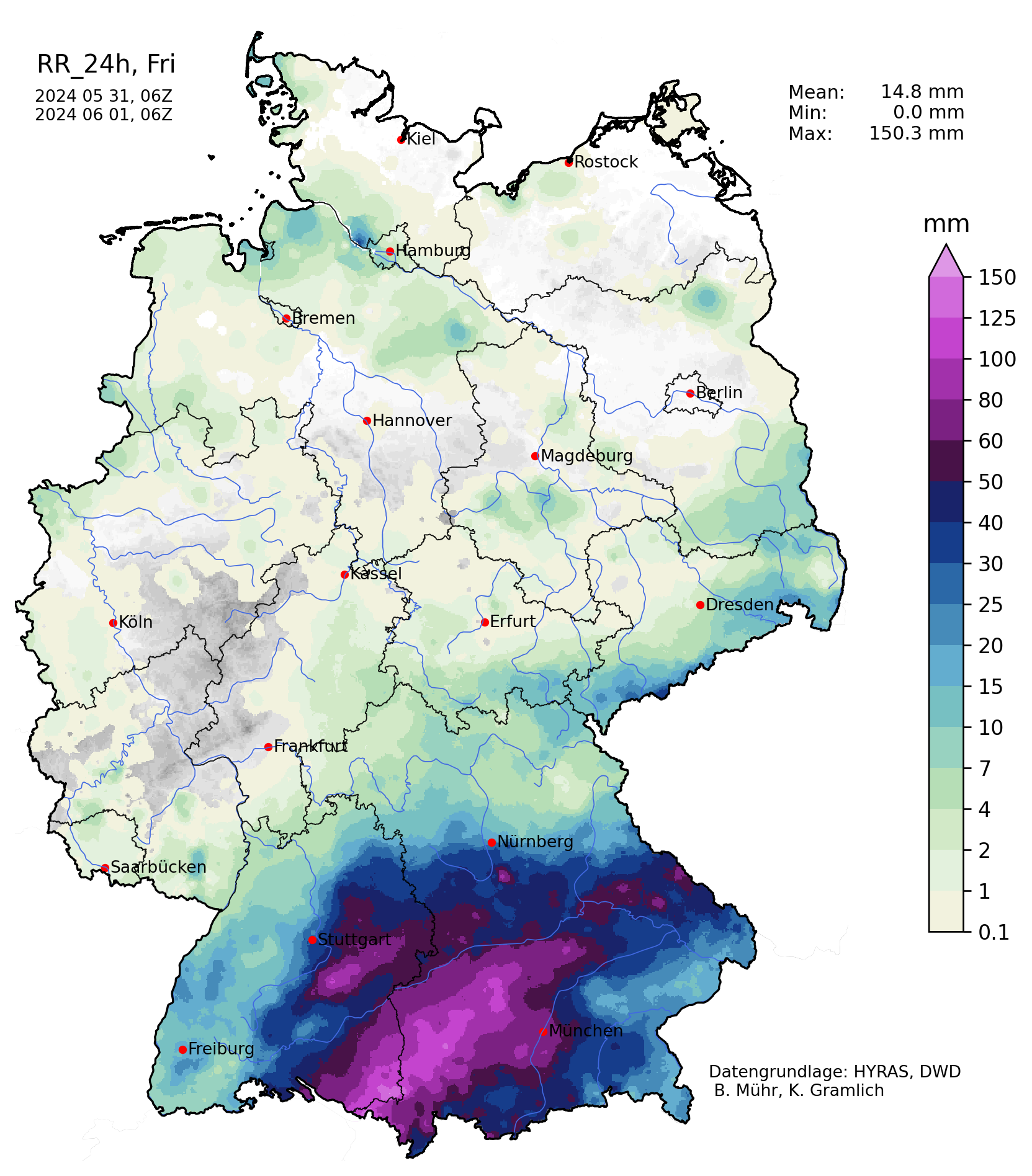
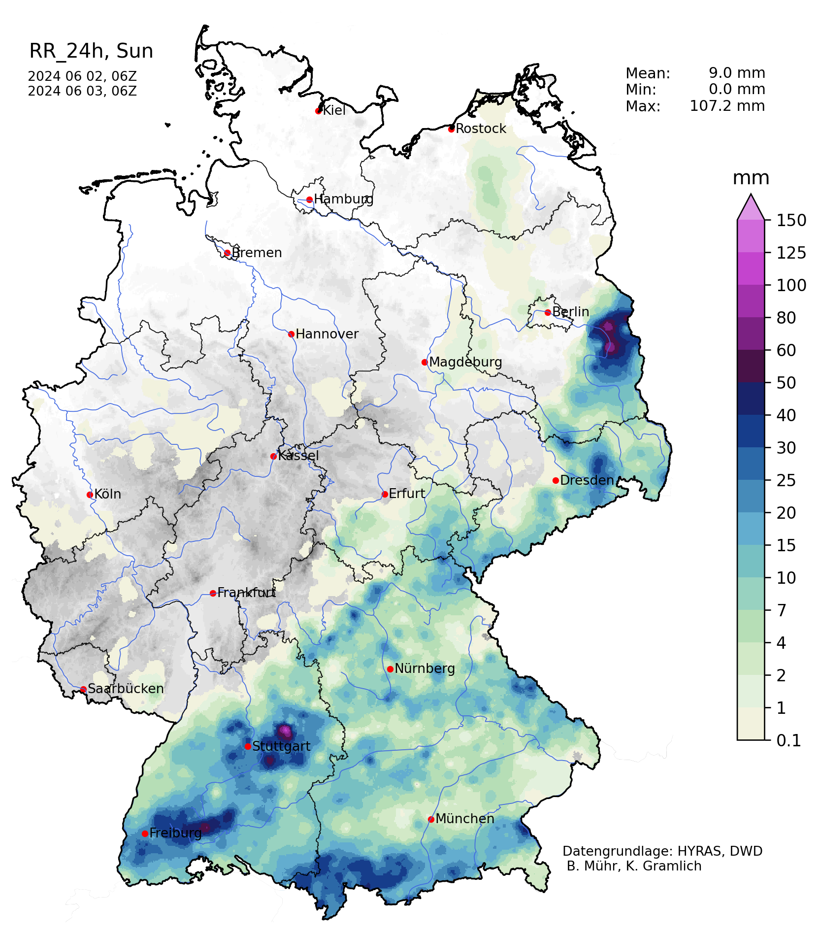
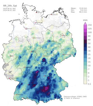
Early on May 31, 2024, the continuous heavy precipitation started to set in over Southern Germany. By the end of the day, many measuring gauges over Southern Germany saw 24 h precipitation totals of more than 100 mm. The highest precipitation totals were observed in the area between the Danube and Isar Rivers with up to 150 mm/24 h in the Allgäu region. A secondary precipitation maximum was observed along northwestwards facing flanks of the Swabian Jura where the orographic lift enhanced the precipitation totals. Here, 24 h precipitation totals reached up to 100 mm. Contrary, to the rains which fell in between the Danube and Isar Rivers, these rains mostly drained into the Neckar River and therefore into the Rhine River.
In the Alps, the comparatively cool air mass led to large fresh snow accumulations. In the Northern Alps, the snow line dropped down to below the 2000 m mark. In some Alpine Valleys, snow was observed down to elevations of only 1500 m. Above 2500 m, fresh snow accumulations of more than 50 cm were observed. At the top of the Zugspitze mountain, fresh snow accumulations of 70 cm were observed, once again increasing the snow depth to more than 400 cm.
|
Heavy snowfall at Lech am Arlberg at 1500 m above sea level, 31.05.2024 12 UTC, source:
Feratel
|
 |
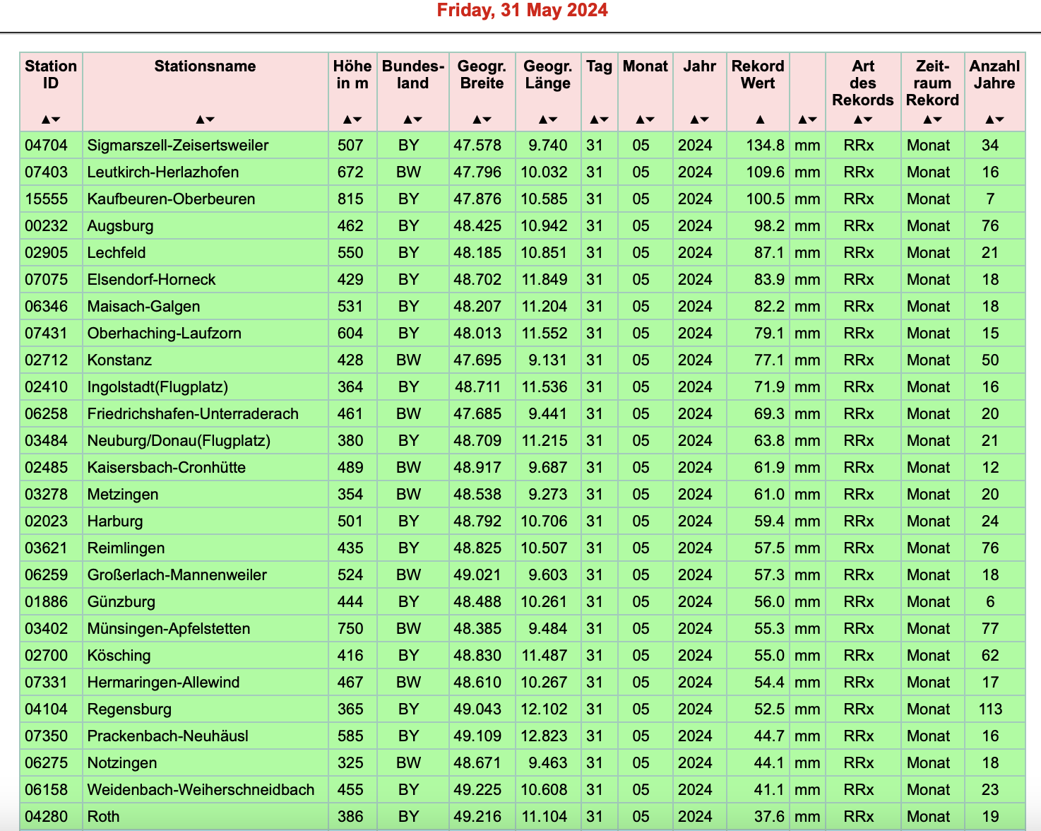
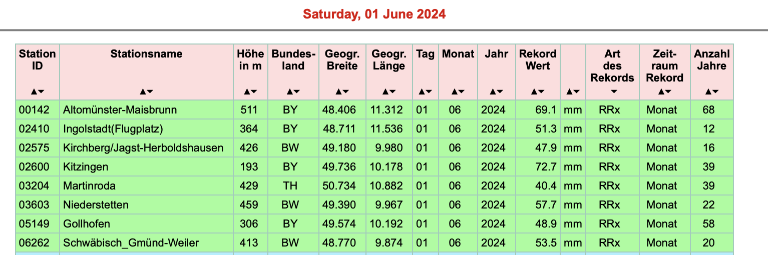
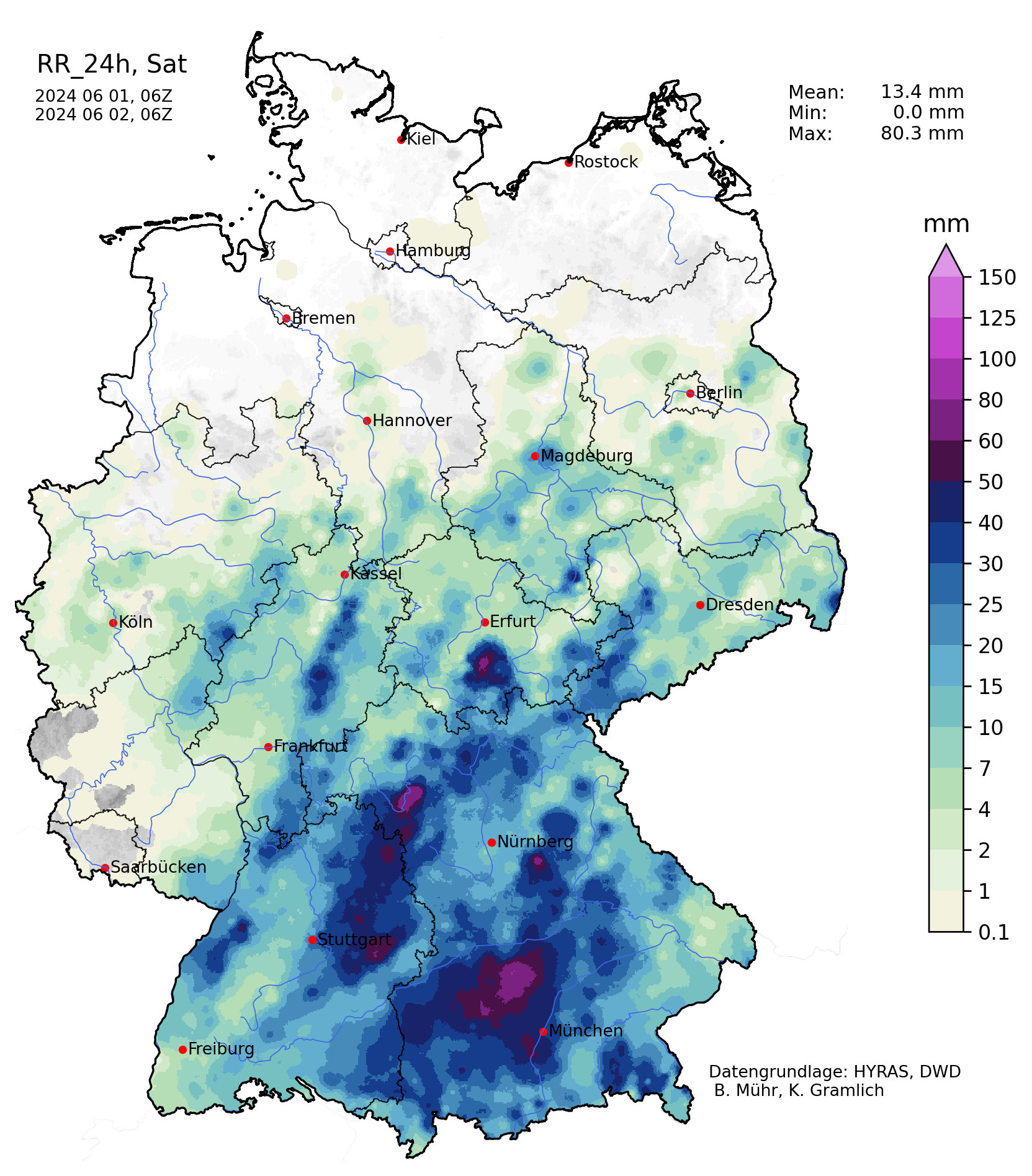
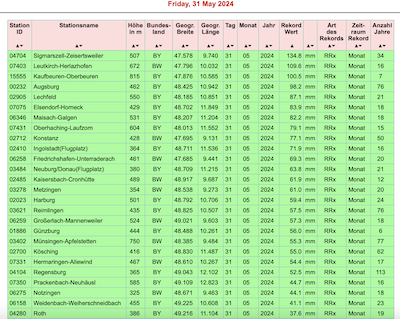
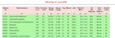
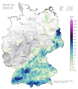
On June 01, 2024, the precipitation at the western edge of the precipitation band slowly subsided, while the entire precipitation band shifted eastwards. The daily precipitation totals reached more than 40 mm over a widespread area. In the area between Munich and the Danube River, the highest precipitation totals with up to 79.8 mm were observed at Schrobenhausen. Further north over Germany, the combination of strong daytime insolation and an unstable air mass led to localized heavy convective downpours. Both on May 31, 2024, and on June 01, 2024, several measuring sites in Southern Baden-Württemberg and Bayern recorded new monthly precipitation records for the respective months.
|
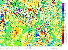
New monthly records of daily precipitation over Germany on 31.05.2024 (left) and 01.06.2024 (right), source:
Wettergefahren-Frühwarnung
|
 |
 |
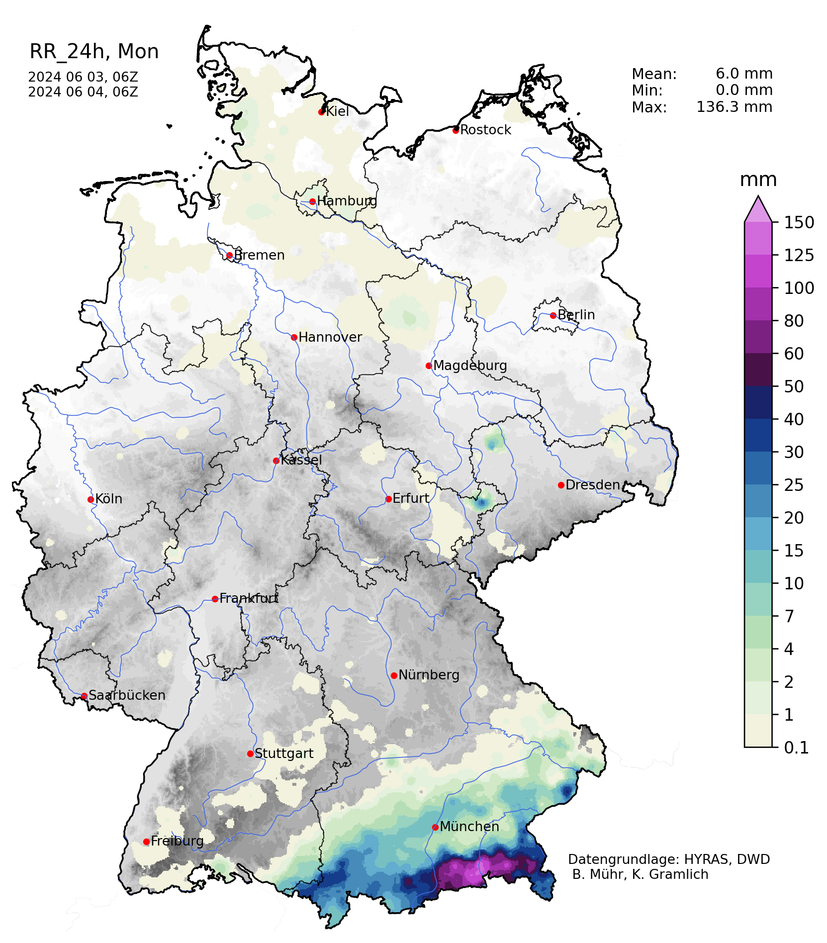
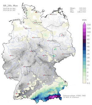
On June 02, 2024, once again heavy precipitation was observed over Southern Germany. While the precipitation weakened over the Danube Plain, strong convectively enhanced precipitation was observed in the Neckar Valley north of the Swabian Jura and the Allgäu region. Here, widespread precipitation totals of more than 30 mm were observed, with a maximum of 107.3 mm at Kaisersbach-Cronhütte, BW. On June 03, 2024, the precipitation shifted once again southeastwards to the Alpine Foothills in Bavaria. The highest daily precipitation was focused along the northernmost part of the Alps in Bavaria. Extreme daily precipitation totals were observed in the county of Rosenheim with daily totals of up to 137.0 mm at Raubling-Pfraundorf. Notably, an extreme north-south precipitation gradient for continuous precipitation was observed in the county, with the northernmost measuring gauges only receiving 3.6 mm of rain in a 24 h period.
|
Daily precipitation totals over Germany, 01.06.2024 (left), 02.06.2024 (middle), and 03.06.2024 (right), source:
Wettergefahren-Frühwarnung
|
 |
 |
 |
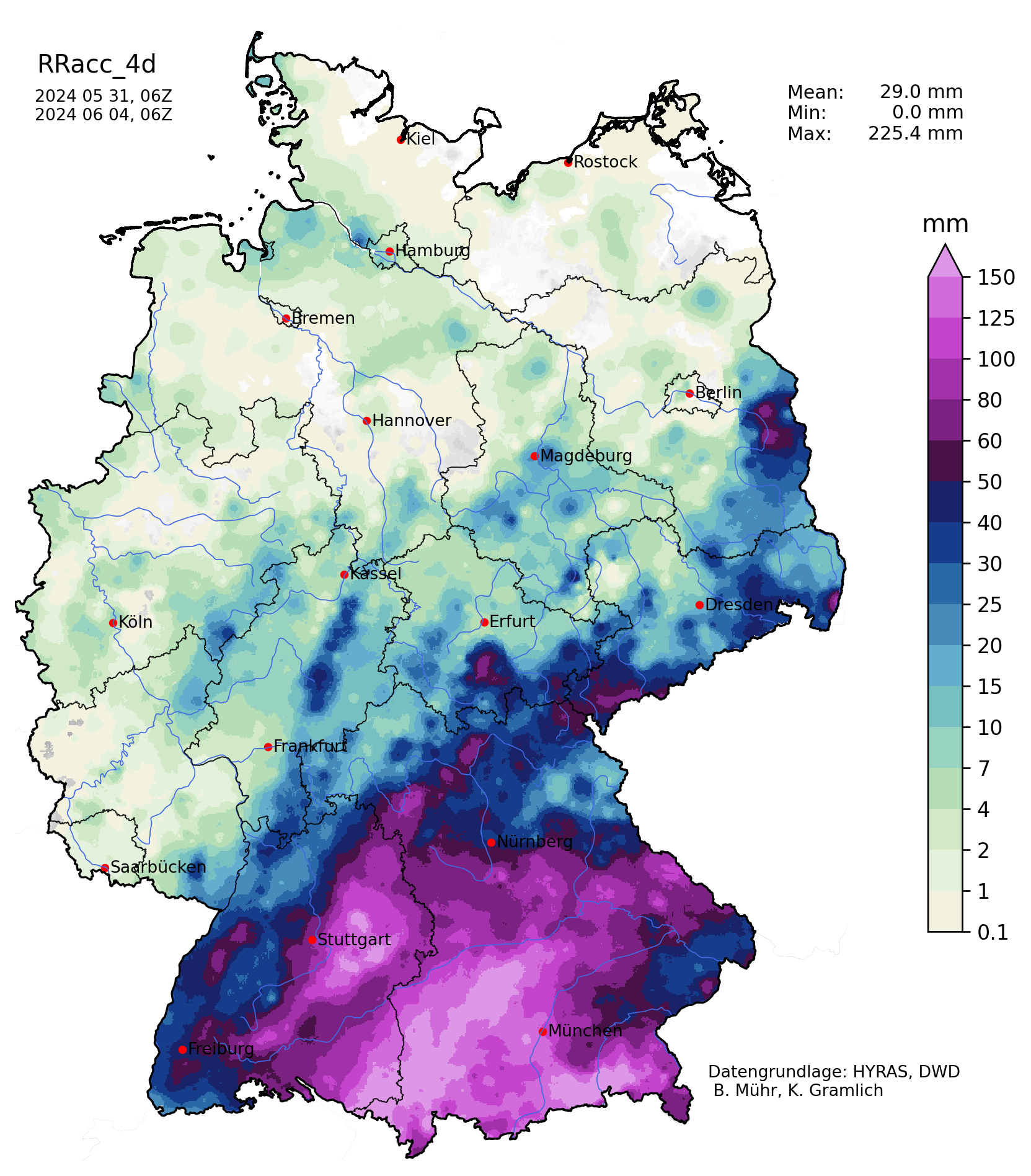
South of the Main River in Bavaria, 96 h precipitation totals of more than 100 mm were observed. Stretching from the Allgäu region into the Danube Plain between the Danube and Isar Rivers, widespread 96 h precipitation totals of more than 150 mm were observed. In the Allgäu region, locally 96 h precipitation totals reached up to 220 mm. 96 h precipitation totals of similar magnitude were observed in the county of Rosenheim due to the intense rains on June 03, 2024. A secondary precipitation maximum was observed along the northwestwards-facing flanks of the Swabian Jura with 96 h precipitation totals of 100 mm, locally up to 150 mm.
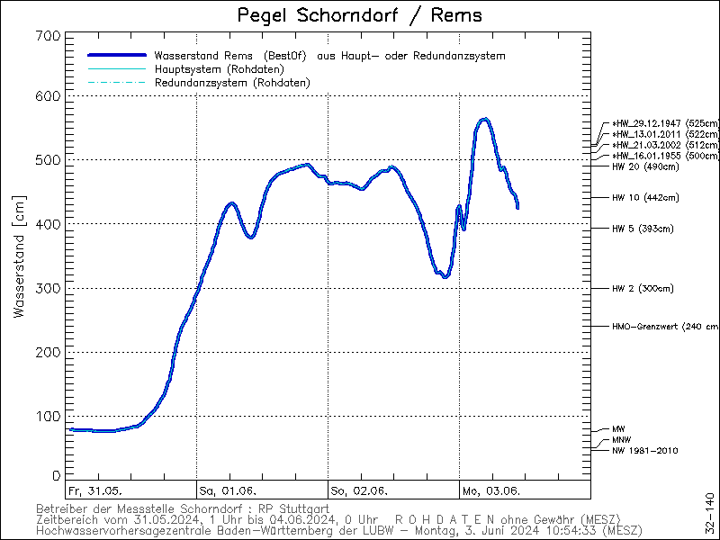
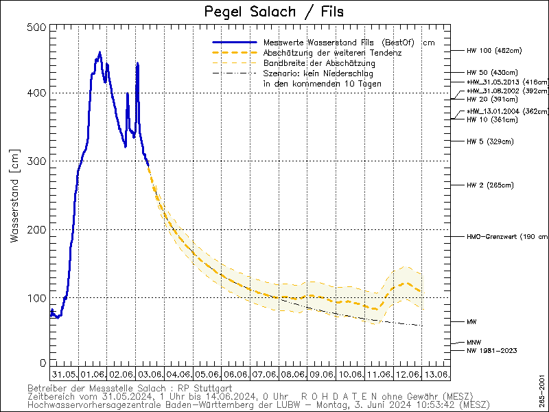
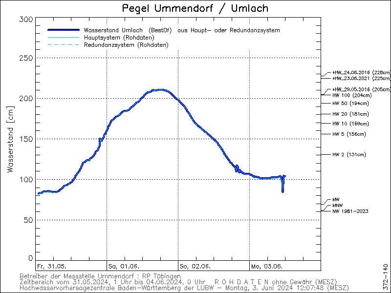
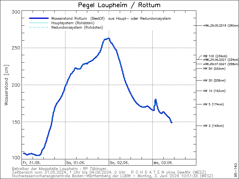
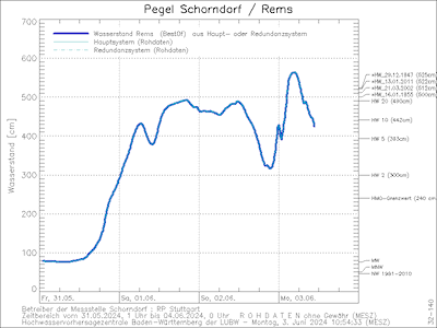
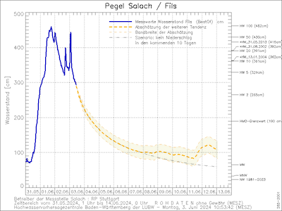
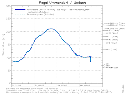
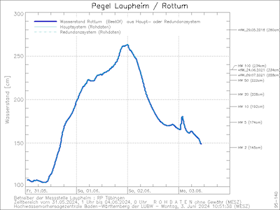
The abundant precipitation in the catchment of the Danube River and Neckar River led to severe river flooding, especially along minor rivers draining the area between the Swabian Jura and the Allgäu region. Many rivers in the said region reached 50-year flood marks over even 100-year flood marks. North of the Swabian Jura, the Fils and Rems Rivers reached severe flooding stages. In Southeastern Baden-Württemberg, minor rivers feeding into the Danube River reached extreme flooding stages with some measuring gauges reaching 100-year flooding levels, especially along the Umlach and Rotturm Rivers on June 01, 2024.
|
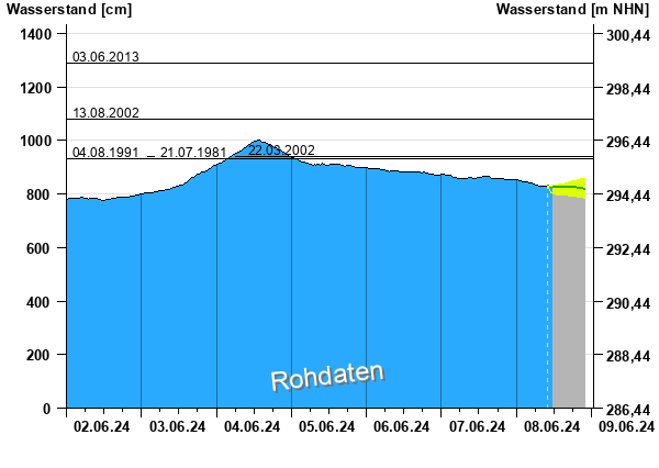
River level of the Rems River at Schondorf (upper left), Fils River at Salach (upper right), Umlach River at Ummendorf (lower left), and Rotturm River at Laupheim (lower right), all seeing severe flooding, 31.05.2024 - 01.06.2024, source:
HVZ Baden-Württemberg
|
 |
 |
 |
 |
In Bavaria, the highest river levels along minor rivers were reached on June 02, 2024. Here the rivers draining the Allgäu region reached the highest flooding stages. Especially along the Günz River, severe damages to residential areas are observed at the mouth of the Günz River at Günzburg. The severity of the flooding increased as a levee failed. Along the Schmutter River, 100-year flood marks were surpassed by quite some margin, also surpassing all recent flood marks from the past decades.
|
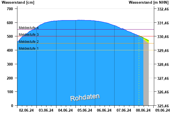
River level of the Günz River at Waldstetten (left), Zusam River at Pfaffenhofen (right), seeing severe flooding, 28.05.2024 - 01.06.2024, source:
HND Bayern
|
 |
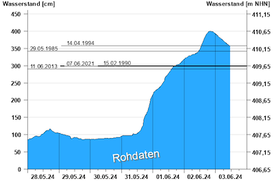 |
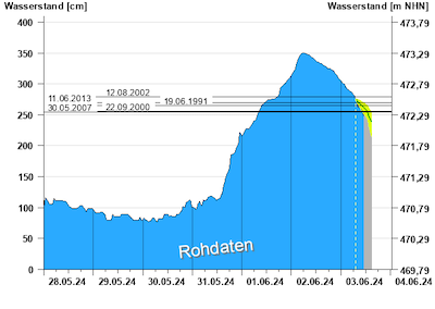
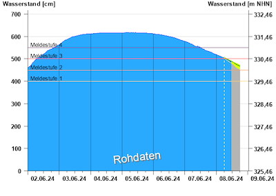
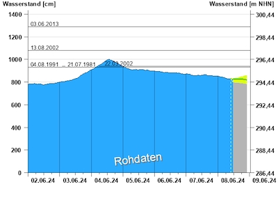
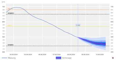
From here, the river flooding shifted into the Danube River on June 03, 2024, with a major river flood occurring along the Danube River in Bavaria. All measuring gauges along the Danube River in Bavaria surpassed flooding stage 4 and for many by quite some margin. Nevertheless, most of the measuring gauges did not reach 100-year floodmarks or extreme floodmarks from previous river floods of the past decades. Notably, the floodmarks from 1999 and 2013 were not surpassed. At Passau, infamous for strong residential flooding during a Danube flood, the Danube River reached a river level of nearly 1000 cm. In the following days, the river levels of the Danube River slowly receded, though river levels remained elevated due to strong run-off persisting in the catchment of the Danube River and the beginning snowmelt at higher elevations in the Alps.
|
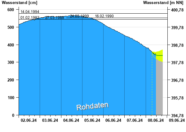
River level of the Danube River at Donauwörth (upper left), Kelheim (upper right), Regensburg (lower left), and Passau (lower right), all seeing severe flooding, 02.06.2024 - 08.06.2024, source:
HND Bayern
|
 |
 |
 |
 |
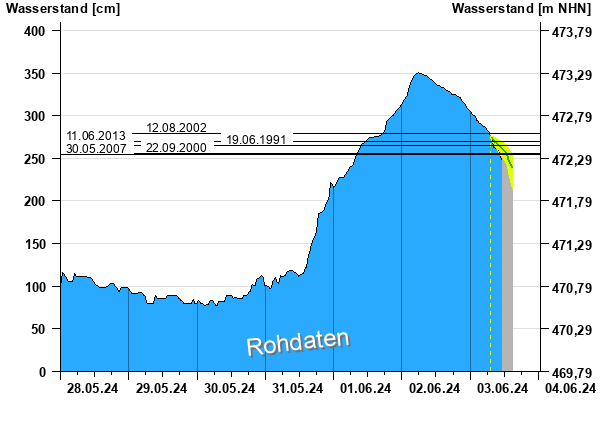
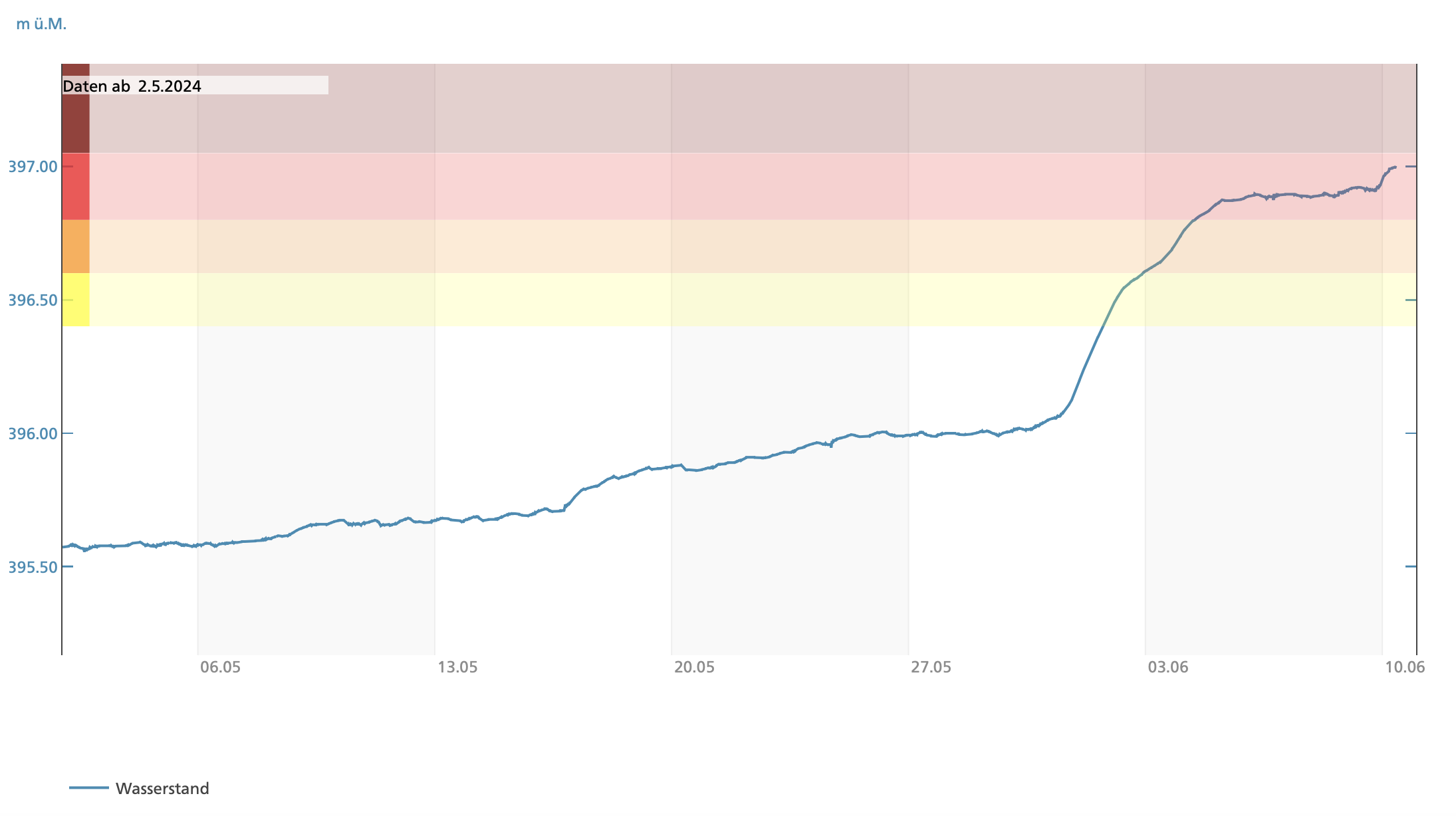
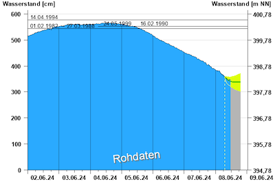
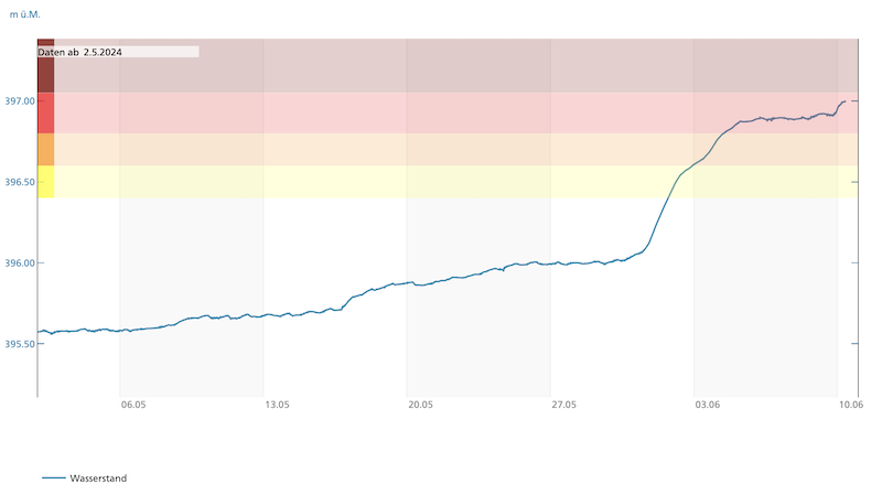
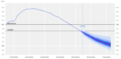
At the German-Swiss border, the combination of the very high precipitation totals in the southern part of Baden-Württemberg and the beginning snowmelt in the Swiss Alps led to very high water levels at Lake Constance. By June 10, 2024, the water levels of Lake Constance at the measuring gauge Berlingen in the lower part of the lake reached 397 m ASL. Although the lake levels are always highest in early summer due to the snowmelt in the Swiss Alps, the current deviations from the average are nearly 150 cm. The high lake levels of Lake Constance will also keep the water level of the High and Upper Rhine at elevated levels for most of the summer months even if the summer precipitation over Southern Germany and Switzerland stay below average.
|
40-day curve of the water level of Lake Constance at Berlingen, 10.06.2024, source:
Hydrodaten.admin.ch
|
 |
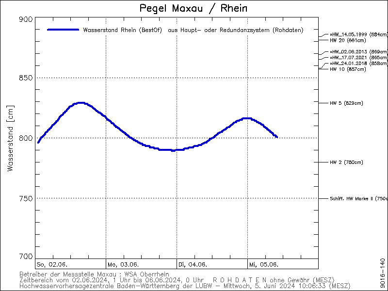
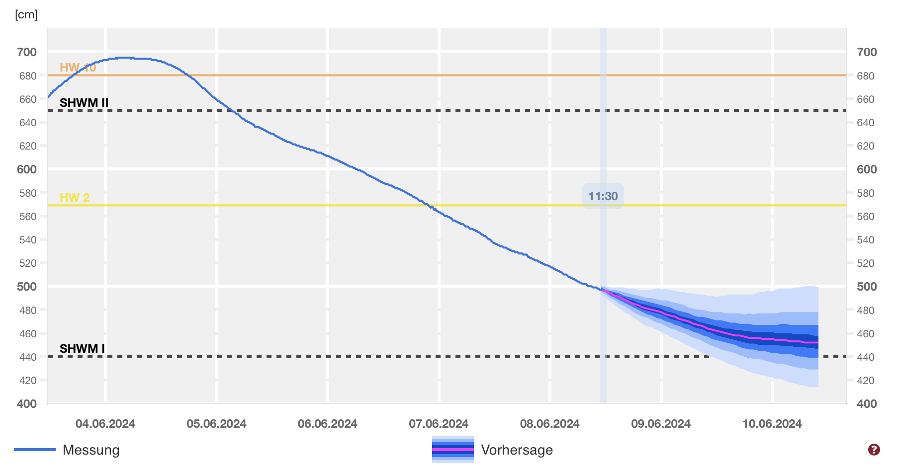
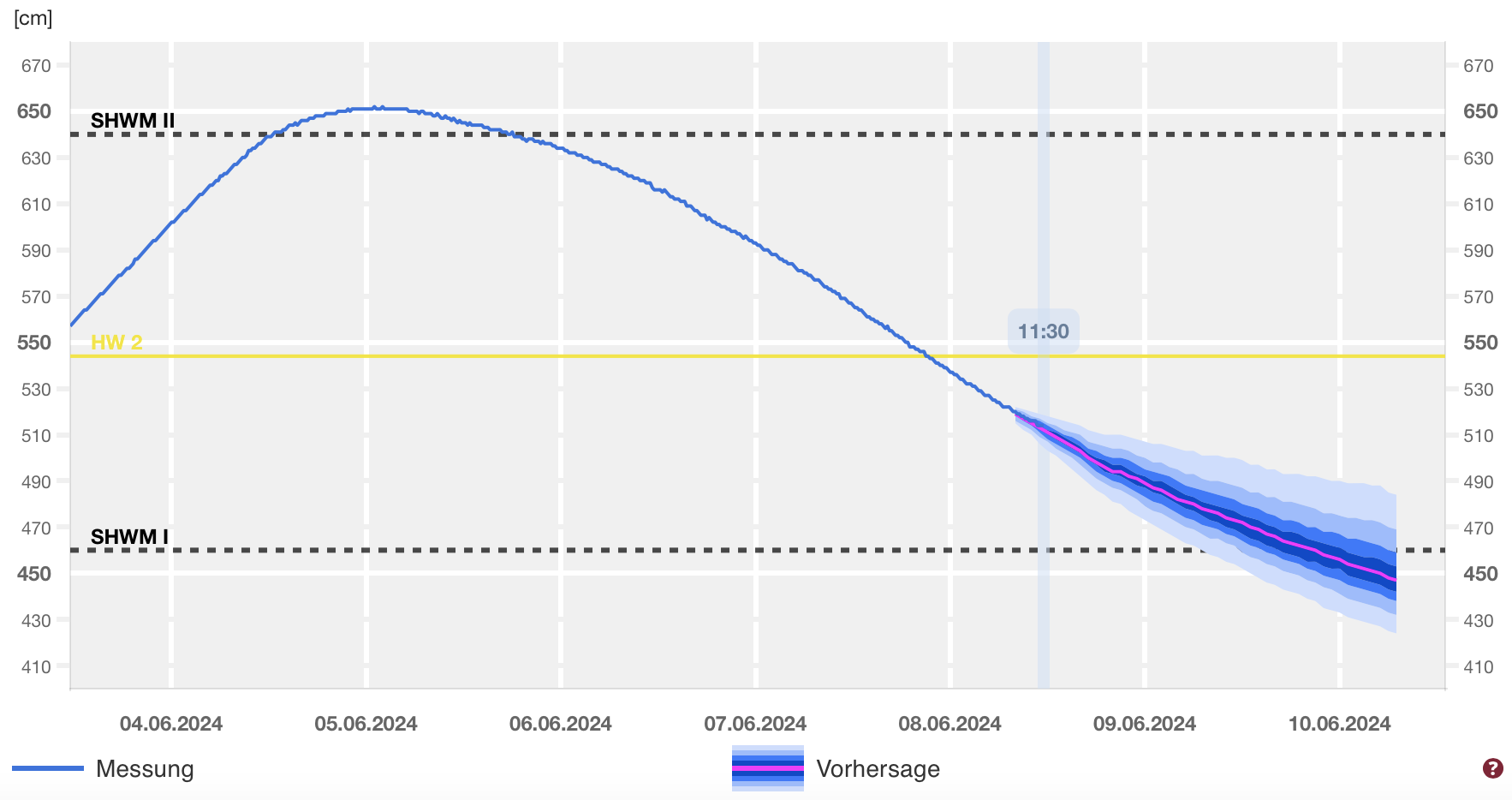
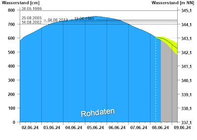
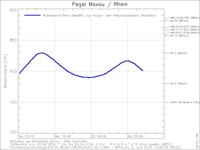
Further downstream of Lake Constance, the river levels of the Rhine River reached also flooding stages. At Maxau, the Rhine River reached a 5-year flood. Due to the high river levels of the Neckar River which reached a 10-year flood due to the intense rains north of the Swabian Jura, the river flood intensified downstream of the mouth of the Neckar River. At Worms, the Rhine River reached a river level of 697 cm, surpassing the 10-year floodmarks. Nevertheless, the river levels of the Rhine were not high enough for the preventive inundation of the polders of the old Rhine River. At the Middle Rhine, the Rhine River reached a 2-year flood, and the water levels were high enough to force a complete stoppage of ship traffic on the river. Downstream of Koblenz, the river flood of the Rhine River weakened and remained below the 2-year floodmarks due to average inflow from the Moselle River.
|
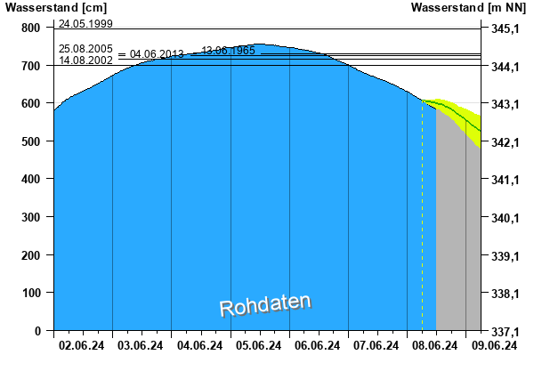
River level of the Rhine River at Maxau (upper left), 02.06.2024 - 05.06.2024, source:
HVZ Baden-Württemberg, Worms (upper right), Kaub (lower left), and Koblenz (lower right), 03.06.2024 - 08.06.2024, source:
Hochwasser RLP
|
 |
 |
 |
 |
The intense rains not only led to severe river flooding in Germany but also many mudslides were caused by soft and saturated soils. At Schwäbisch Gmünd, a mudslide caused the derailment of a German high-speed train with almost 200 passengers. In Bavaria, multiple sections of different autobahns were inundated by the heavy rains, locally for multiple days. Further, the railway connections from the west and the north to Munich were closed due to flooding concerns for multiple days, leading to widespread delays and train cancellations in the German railway network.
In Bavaria, the severe river flooding especially in the region around Günzburg raised concerns about insufficient flood protection for low-lying residential areas. Especially since the past decades of large urban development in the Danube Plain led to many new residential areas being built in flood-prone areas. First estimates by insurance companies estimate the insured damages in Southern Germany to be as high as 2 billion €. Sadly, in the aftermath of the flood, 9 people lost their lives in Germany.
Text: KG
June 03, 2024
updated: KG
June 10, 2024
|