|
Hurricane HELENE was a large and powerful category 4 hurricane that made landfall near peak intensity in the Florida Big Bend region. Upon landfall Hurricane HELENE had sustained winds of 220 kph and a central pressure of 938 hPa. Hurricane HELENE was the third hurricane to make landfall in the Florida Big Bend region in the last 13 months. The large and fast-moving hurricane brought a catastrophic storm surge to the Florida Big Bend region and torrential rains to the Southeastern US leading to catastrophic river flooding.
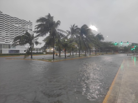
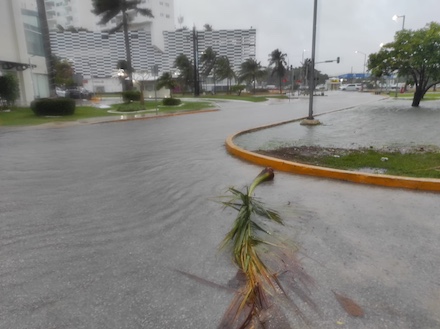
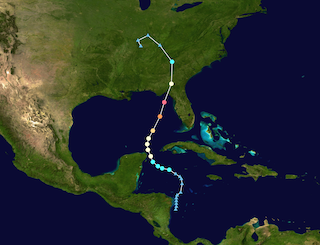
The tropical disturbance that would eventually mature into Hurricane HELENE formed over the Caribbean Sea on September 24, 2024. Later on September 24, 2024, the tropical disturbance strengthened into tropical storm HELENE. From its initial development location in the Northern Caribbean Sea, the system slowly moved northwestwards. Before reaching the Yucatán Channel between Western Cuba and the Yucatán Peninsula, the system made only a gradual development. By September 25, 2024, the system reached hurricane strength over the Yucatán Channel. Moving close to the Yucatán Peninsula, Hurricane HELENE brought strong winds and heavy rains to the region around Cancún. Precipitation totals of 240 mm were observed over the Yucatán Peninsula.
|
High winds and flooding due to Hurricane HELENE in Cancún, MX, 25.09.2024 15:30 UTC, source:
S. Baumstark
|
 |
 |
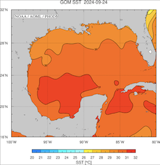
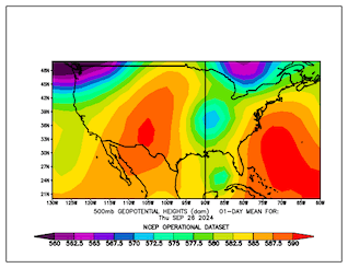
Early on September 26, 2024, Hurricane HELENE was located just north of the Yucatán Channel over the Gulf of Mexico. At 00 UTC, Hurricane HELENE had a central pressure of 972 hPa and maximum sustained winds of 140 kph. Moving northeastwards across the Gulf of Mexico, Hurricane HELENE found favorable conditions to intensify. The environment around the hurricane had weak mid-level shear and an upper-level trough stretching far southwards, providing upper-level divergence. Further, the very warm waters of the Gulf of Mexico supported the intensification of the system. In the Gulf, sea surface temperatures (SSTs) reached more than 30 °C, with local maxima of 31 °C. This provided a large thermal energy reservoir for the hurricane to tap into.
|
Track and intensity of Hurricane HELENE (left), source: NASA, SSTs of the Gulf of Mexico (middle), 24.09.2024, source: AOML NOAA, and the averaged 500 hPa geopotential over the US (right), 26.09.2024, source:
PSL NOAA
|
 |
 |
 |
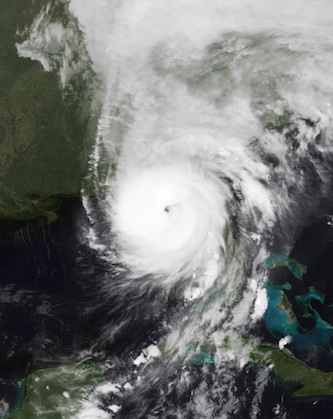
On September 26, 2024, Hurricane HELENE started to interact with a mid-level trough located over the Mississippi Valley. Sitting east of the trough axis, the tropical cyclone was advected swiftly northeastwards ahead of the mid-level trough. Due to this synoptic forcing, the hurricane accelerated considerably and traversed the entire Gulf of Mexico from south to north in a bit more than 24 h. Meanwhile, Hurricane HELENE strengthened rapidly due to the favorable environment. By midday, Hurricane HELENE had already intensified into a category 2 hurricane with sustained winds of 165 kph and a central pressure of 960 hPa. In the second half of the day, the intensification rate of Hurricane HELENE increased sharply. Within a 12 h period, Hurricane HELENE developed from a category 2 hurricane into a category 4 hurricane.
Visible satellite imagery of Hurricane HELENE over the Gulf of Mexico
before making landfall in the Florida Big Bend region, 26.09.2024,
source:
NASA Worldview
|
 |
During these 12 hours, the sustained winds of Hurricane HELENE increased from 165 kph to 220 kph while moving northeastwards across the Gulf of Mexico. At the same time, the central pressure of Hurricane HELENE decreased by 22 hPa from 960 hPa to 938 hPa. On September 26, 2024, Hurricane HELENE underwent a rapid intensification. The hurricane developed from a category 1 hurricane into a large and powerful category 4 hurricane, decreasing its central pressure by 34 hPa and increasing its sustained winds by 80 kph.
|
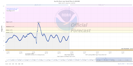
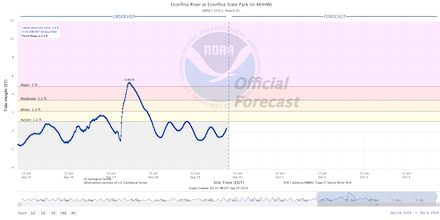
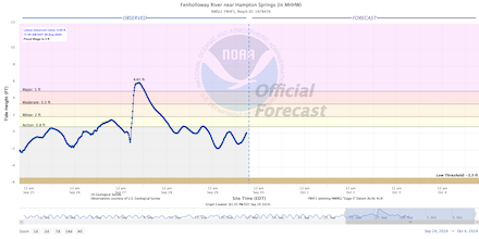
Storm surge of Hurricane HELENE observed at different measuring gauges along the Floridian Gulf Coast, Aucilla River near Nutall Rise (upper left), Econfina River at the Econfina River State Park (upper right), Fenholloway River near Hampton Springs (lower left), and Gulf of Mexico Tide Gauge at Cedar Key (lower right), source:
Water NOAA
|
 |
 |
 |
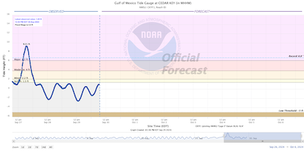 |
Due to its rapid forward motion, Hurricane HELENE made landfall in the Florida Big Bend region near peak intensity early on September 27, 2024. Hurricane HELENE moved onshore near Perry, FL in the Apalachee Bay as a large and powerful category 4 hurricane. Only 13 months prior, category 3 Hurricane IDALIA made landfall in the Apalachee Bay about 20 km away from the landfalling point of Hurricane HELENE. Furthermore, Hurricane Debby made landfall as a slow-moving category 1 hurricane at Steinhatchee, FL on August 04, 2024, only around 50 km away from the landfalling point of Hurricane HELENE. The combination of the rapid forward motion of Hurricane HELENE with speeds of more than 30 kph and powerful winds, a catastrophic storm surge was forecasted to impact the Apalachee Bay. At Steinhatchee, FL, a measuring gauge recorded a storm surge of up to 3 m before the device stopped transmitting data. Due to the large size of the hurricane, even the Tampa Bay Area recorded a severe storm surge with a height of 2.19 m. As a reference, the Tampa Bay Area is about 270 km away from the landfalling point of Hurricane HELENE.
|
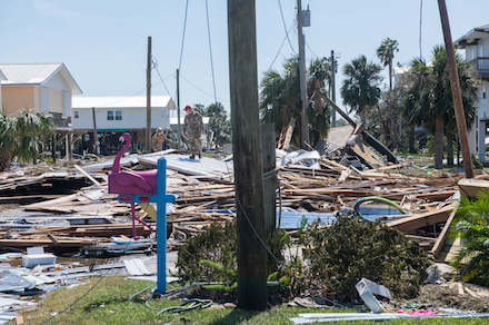
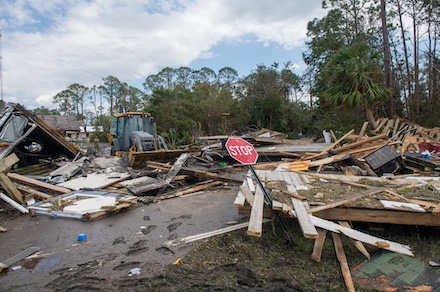
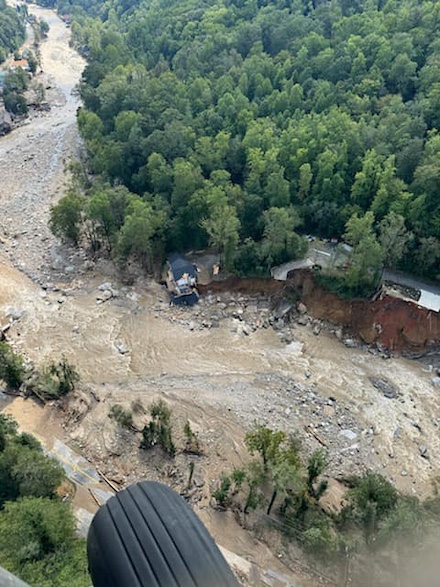
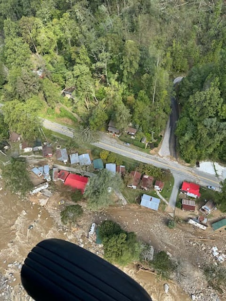
Storm damages due to Hurricane HELENE at Keaton Beach, FL (upper row), 27.09.2024, source:
Florida National Guard, and extensive flooding damages in the southern Appalachians in North Carolina, 28.09.2024, source:
Connecticut National Guard
|
 |
 |
 |
 |
As the tropical cyclone moved northwards into Georgia, the rapid forward motion allowed Hurricane HELENE to remain remarkably well-organized. The severity of the weather conditions in the southeastern part of the US was correctly assessed by the Waffle House Index. Ahead of the storm, the index turned red as multiple venues of the restaurant chain in Northern Florida and Southern Georgia intermitted operations. Heavy rains were observed throughout Georgia and the southern Appalachians. Even far inland, violent wind gusts of up to 148 kph were recorded at Douglas in the central part of Georgia. The hurricane reached the southern Appalachians, remaining upstream of the trough located over the Midwest. With the orographic lift, precipitation rates in parts of Georgia, the Carolinas, and Tennessee were enhanced. Widespread rain accumulations of more than 200 mm led to locally catastrophic flash and river flooding. In addition, Hurricane HELENE also induced a severe weather outbreak spawning multiple tornadoes.
|
5-day precipitation totals over the Southeastern US, 23.09.2024 12 UTC - 28.09.2024 12 UTC, source:
Water NOAA
|
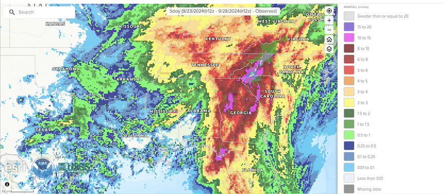 |
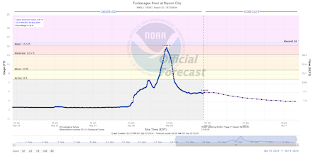
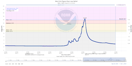
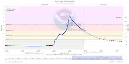
Atlanta, GA recorded its highest 3-day precipitation total with an accumulation of 295 mm. The heavy rains in the area led to urban flooding. Far worse flooding was reported from the southern Appalachians where extremely heavy rains impacted an area previously under severe drought conditions. At Busick, NC, Hurricane HELENE brought a precipitation total of 751 mm. As a result, many rivers in the southern Appalachians rose to severe or even extreme flooding levels. Mudslides and elevated water levels impaired many roadways in this area. In the city of Asheville, NC, a curfew was enforced due to the severity of the river flooding impacting the city. In the evening hours of September 27, 2024, the remnants of Hurricane HELENE turned extratropical and continued to move cyclonically around the mid-level trough situated over the Midwest. After its extratropical transition, the low stalled over the Bowling Green Area on September 28, 2024, bringing heavy rains to much of the Midwest as the storm slowly dissipated in the following days.
|
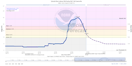
River flooding in the Southeastern US due to the torrential rains of Hurricane HELENE observed at different measuring gauges, Saluda River at Greenville, SC (upper left), Tuckasegee River at Bryson City, NC (upper right), West Fork Pigeon River near Bethel, NC (lower left), and French Broad River at Asheville, NC (lower right), source:
Water NOAA
|
 |
 |
 |
 |
With Hurricane HELENE, the fifth straight year of a landfalling major hurricane in the Continuous US has been recorded. Furthermore, Hurricane HELENE is already the fourth landfalling hurricane along the Gulf Coast this year. Only 5 other years had at least four landfalling hurricanes along the Gulf Coast since record-keeping began in 1851. Hurricane HELENE with its sustained winds of 220 kph upon landfall also surpassed the Cedar Keys Hurricane from 1896 with its sustained winds of 200 kph as the strongest landfalling hurricane in the Florida Big Bend region. Important to highlight is that before Hurricane IDALIA in August of last year, no hurricane had made landfall in Apalachee Bay in recorded history. In the past 13 months, 2 major hurricanes have now made landfall in this area. Moreover, Hurricane HELENE had one of the largest diameters before making landfall in the US. Since Hurricane IRMA in 2017, no larger hurricane than Hurricane HELENE made landfall in the US. Some parts of Florida directly impacted by Hurricane HELENE received only very little rain for tropical cyclone standards due to the rapid motion of the system. Here, precipitation totals reached only 50 to 100 mm.
Currently, 118 fatalities are related to Hurricane HELENE, all reported by the US. Notably, only 13 fatalities have been reported from Florida where Hurricane HELENE made landfall. Most fatalities have been reported in Georgia and the Carolinas where the excessive rainfall of Hurricane HELENE caused widespread flooding. At the peak, more than a million customers were without power in the path of Hurricane HELENE. Due to the extensive flooding in these two states, early damage estimates by insurance companies show financial losses of up to 20 billion $.
Text: KG
September 30, 2024
|


