|
Two rare tropical cyclones in Southeast Asia concurrently led to catastrophic flooding in Sri Lanka, Malaysia, and Indonesia, killing at least 1,000 people. Cyclonic Storm SENYAR was one of the closest tropical cyclones to the equator in recorded history, with a minimal latitude of around 3 °N, and is among the most costly in the North Indian Basin. Cyclonic Storm DITWAH impacted Sri Lanka, forming also unusually close to the equator.
In late November 2025, two extremely rare tropical cyclones formed over the North Indian Ocean. Both were located unusually close to the equator. Although these low-pressure systems are named tropical cyclones, they typically need to be off the equator by at least 5 ° of latitude. Reason, therefore, is the necessity for a strong enough Coriolis force to balance forces in a tropical cyclone. Hence, no tropical cyclone forms at the equator. Formations close to the equator are exceedingly rare. Thus, the formation of Cyclonic Storm SENYAR over the Strait of Malacca and the formation of Cyclonic Storm DITWAH south of Sri Lanka alone would have been a rare occurrence. But the combination of both forming nearly concurrently makes this event exceedingly rare.
Cyclonic Strom SENYAR – Indonesia, Malaysia, Thailand – 23 - 30 November 2025
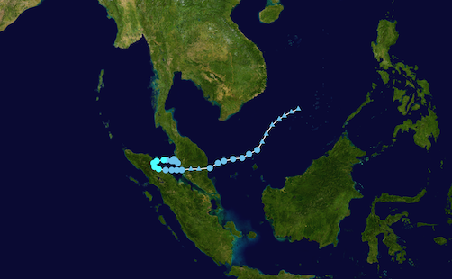
Cyclonic Storm SENYAR was the tropical cyclone that formed closer to the equator of the two. SENYAR formed over the narrow Strait of Malacca between the Malay Peninsula of Malaysia and the Indonesian Island of Sumatra on November 23, 2025. The average depth of the Strait of Malacca is only 25 m, providing a tropical cyclone with only a minimal ocean heat content to fuel its intensification. In addition, the Strait of Malacca is only 250 km wide in this region. Furthermore, SENYAR formed very close to the equator with a latitude of only 4.5 °N. Tropical cyclone SENYAR initially moved westwards across the Strait of Malacca, making landfall at peak intensity with sustained winds of 85&tinsp;kph and a central pressure of 996 hPa along the northeastern coast of Sumatra late on November 25, 2025.
|
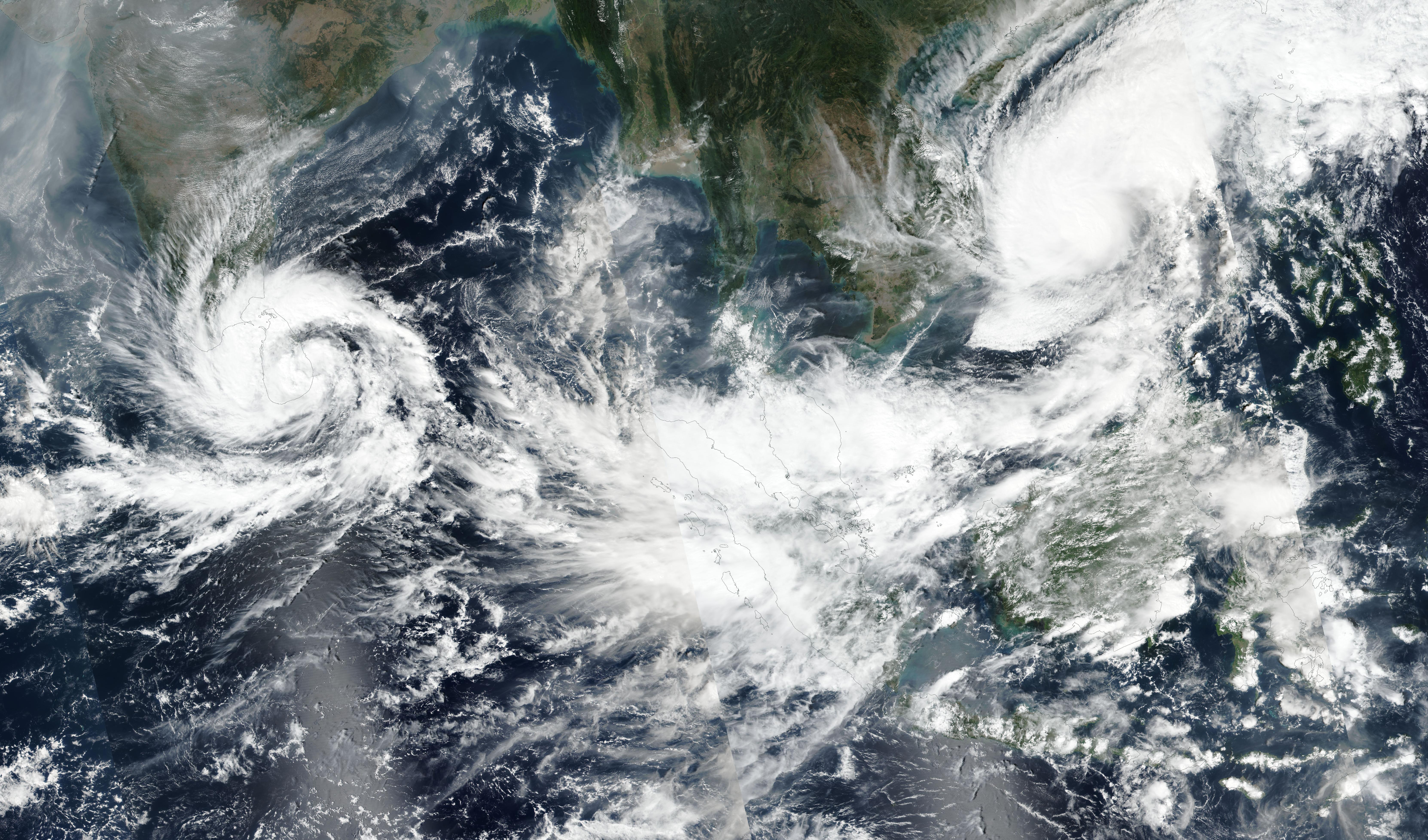
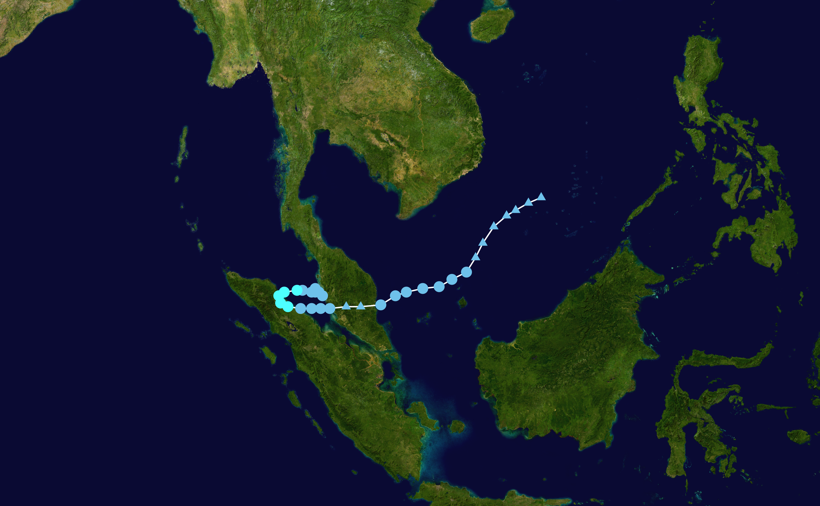
Track and intensity of Cyclonic Storm SENYAR (left), source:
NASA, and visible satellite imagery of Cyclonic Storm SENYAR over Norhtern Sumatra near peak intensity, 26.11.2025 (right), source:
NASA Worldview
|
 |
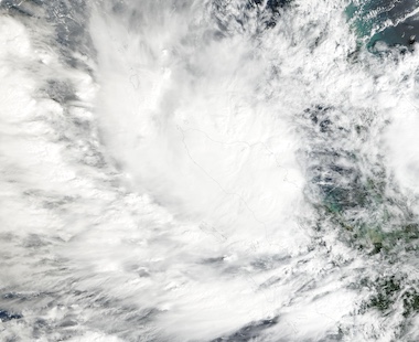 |
Over Sumatra, the tropical cyclone made an unusually southward turn and approached the equator. SENYAR passed close to the city of Medan on Sumatra before the cyclone reemerged onto the Strait of Malacca on November 26, 2025. Late on November 26, 2025, the core of Cyclonic Storm SENYAR reached its most southerly position with a minimal latitude of only 3 °N. The cyclone tracked across the Strait of Malacca and made landfall north of Kuala Lumpur on November 27, 2025, as a tropical depression with sustained winds of 45 kph and a central pressure of 1,005 hPa. The following day, SENYAR traversed the Malay Peninsula and emerged into the South China Sea. This marks the first tropical cyclone that completed a traverse from the Indian Ocean into the Pacific and thus into the responsibility area of the Japan Meteorological Agency. Over the South China Sea, SENYAR started to interact with Typhoon KOTO and shifted to a northeasterly track. Ultimately, the circulation related to tropical cyclone SENYAR faded on November 30, 2025.
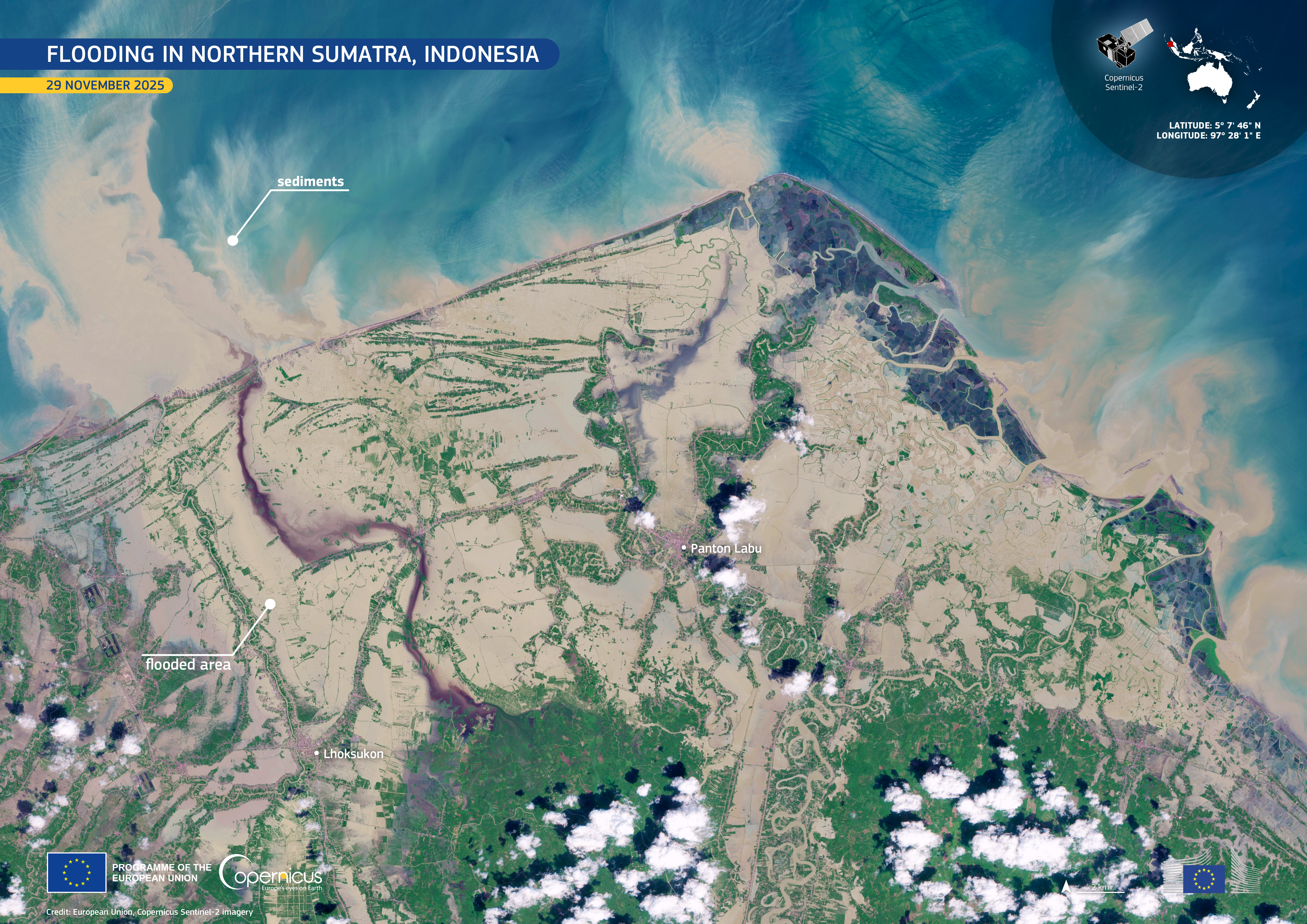
Visible satellite imagery over Northern Sumatra showing the extensive river flooding and drainage after the passage of Cyclonic
Storm SENYAR, 29.11.2025, source:
Copernicus - Image of the day, Credit: European Union, Copernicus Sentinel-2 imagery
|
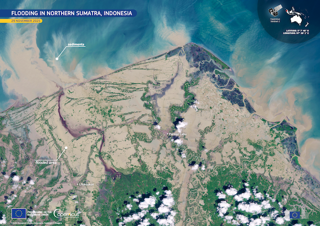 |
During its extremely rare life cycle, Cyclone Strom SENYAR brought torrential rains, flash flooding, and mudslides to the Indonesian island of Sumatra and the Malay Peninsula. These tropical regions are typically too close to the equator for tropical cyclone formation, and thus, the damage of a comparatively weak tropical cyclone was catastrophic. The torrential rains associated with Cyclonic Storm SENYAR led to extensive flash and river flooding, as seen in the above attached satellite imagery. In Indonesia alone, at least 686 people are reported dead, with many people still missing. A further 267 people have been reported dead in Thailand. In Hat Yai, the fifth-largest city of Thailand, daily precipitation reached 335 mm, which is the largest single-day precipitation total in the city in at least 300 years. Preliminary damages estimate of Cyclonic Storm SENYAR suggests that the tropical cyclone caused more than 7 billion $ in damages, making SENYAR the fifth-costliest tropical cyclone on record in the North Indian basin.
Cyclonic Strom DITWAH – Sri Lanka and India – 24 - 30 November 2025
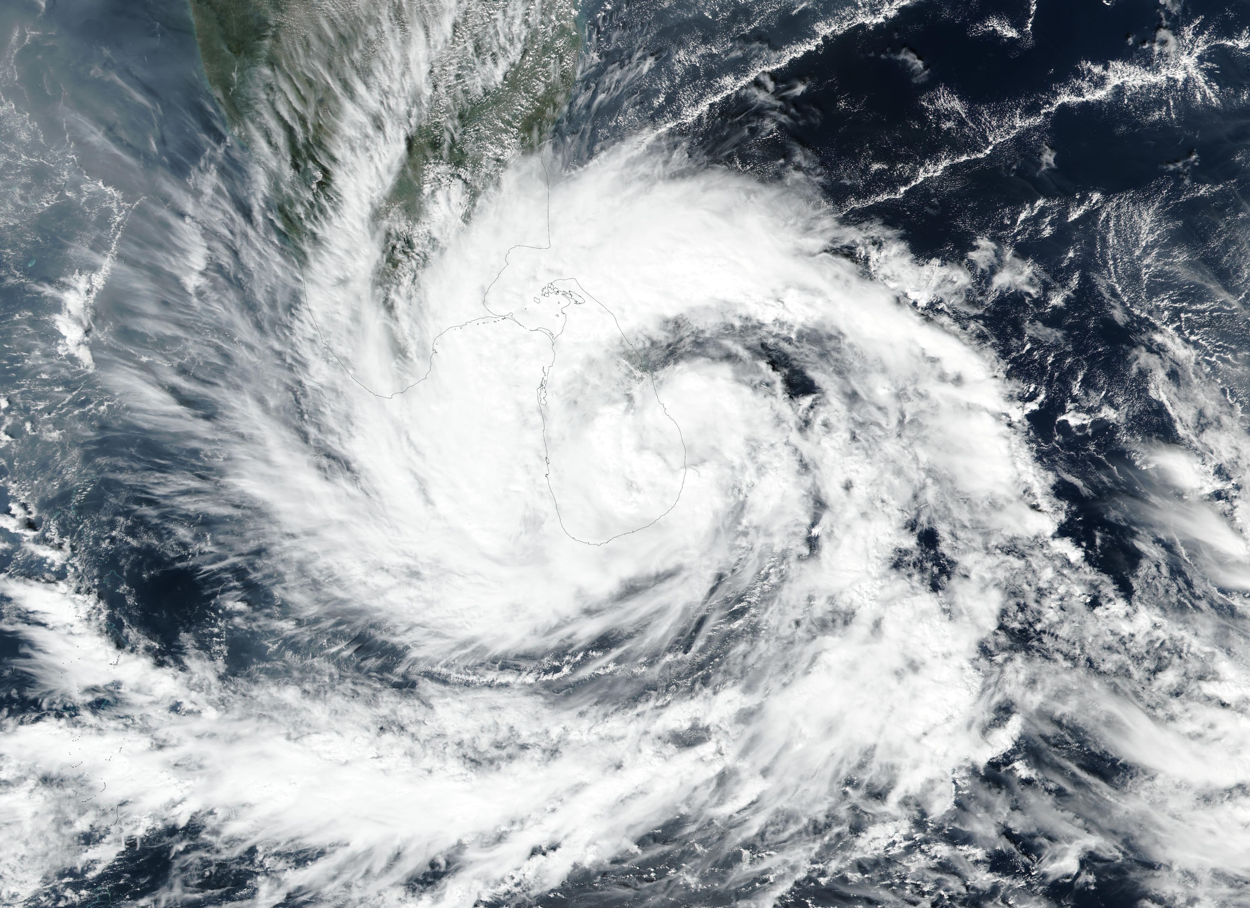
Nearly concurrently with the formation of Cyclonic Storm SENYAR, a second tropical cyclone formed over the North Indian basin. Located just south of Sri Lanka, tropical depression DITWAH formed at a latitude of only 5 °N on November 24, 2025. In the following days, the tropical depression tracked around the island of Sri Lanka. By November 27, 2025, Cyclonic Storm DITWAH made landfall on Sri Lanka. Due to the interactions with the island of Sri Lanka, the circulation center of Cyclonic Storm DITWAH was not always well defined. Subsequently, the official track is wavy and makes the exact landfalling point ill-defined with the current data. Over Sri Lanka, Cyclonic Storm DITWAH reached its peak intensity with sustained winds of 65 kph and a minimum central pressure of 1,002 hPa. In the following days, DITWAH slowly tracked northwards across Sri Lanka.
|
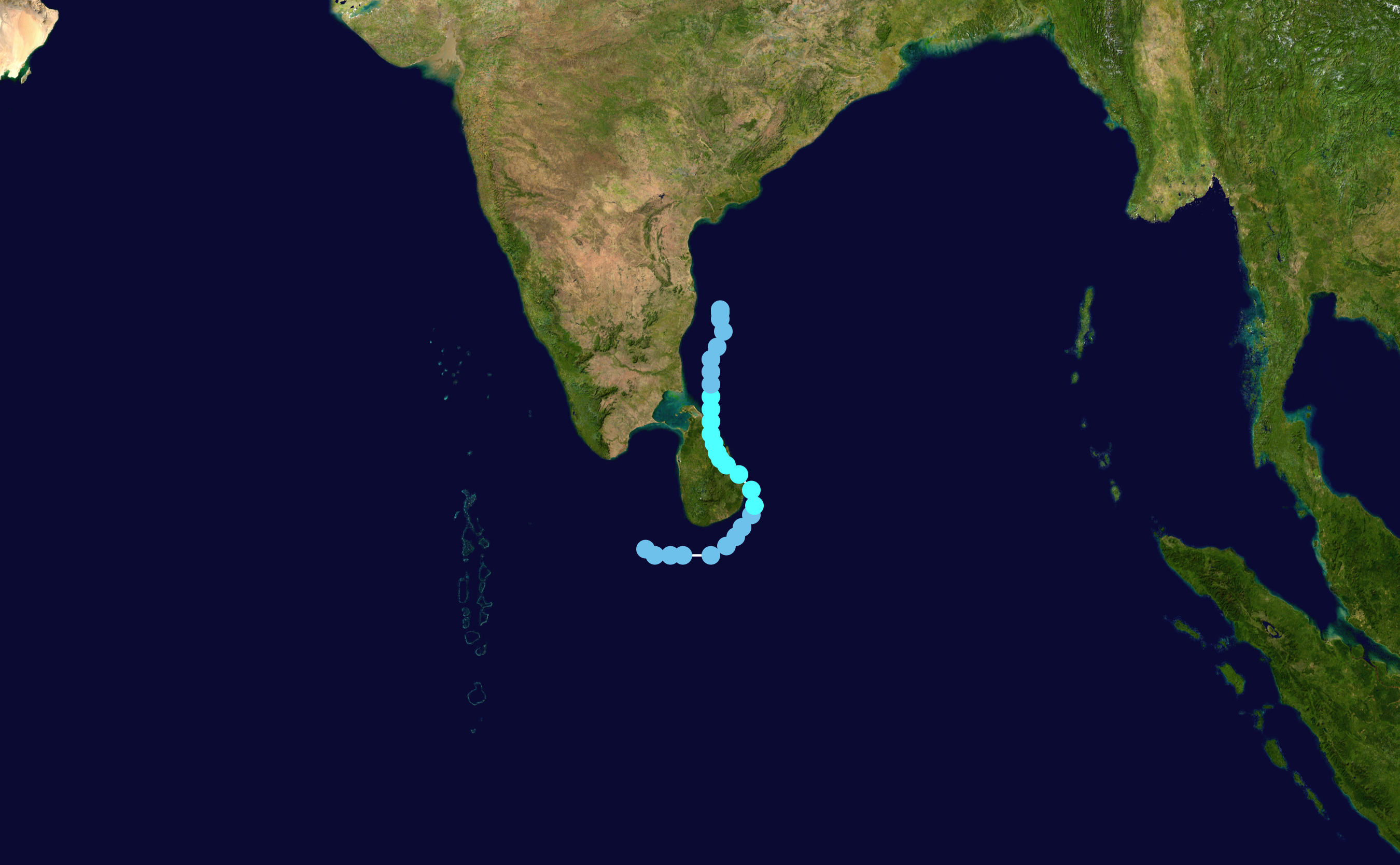
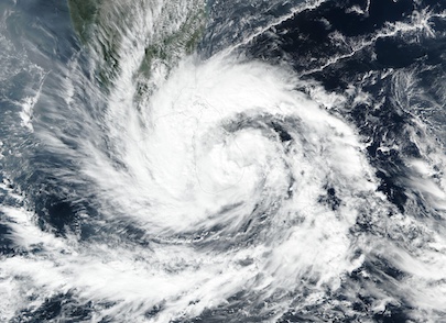
Track and intensity of Cyclonic Storm DITWAH (left), source:
NASA, and visible satellite imagery of Cyclonic Storm DITWAH over Sri Lanka near peak intensity, 27.11.2025 (right), source:
NASA Worldview
|
 |
 |
The cyclonic storm emerged over the Bay of Bengal on November 29, 2025, and continued to slowly track northwards across the Bay of Bengal. The tropical cyclone weakened into a tropical depression and dissipated on November 30, 2025. During its lifecycle, DITWAH brought torrential rains to Sri Lanka. The downpours led to flash flooding and countless mudslides on the island, leading to widespread damage. The southeastern parts of India were also affected by heavy rains related to Cyclonic Storm DITWAH. More than 400 people are reported dead in Sri Lanka, with many people still missing. Early estimates suggest that Cyclonic Storm DITWAH caused nearly 1 billion $ in damages on the island.
In total, both Cyclonic Storms in Southeast Asia led to the death of more than 1,000 people. Although both tropical cyclones were comparatively weak, both led to a larger loss of life than the extremely powerful Hurricane MELISSA, which mainly impacted Jamaica in late October 2025. This is in part caused by the extremely rare occurrence of both tropical cyclones. As mentioned, both tropical cyclones formed unusually close to the equator. That both tropical cyclones were concurrently active marks an exceptionally rare occurrence. With a minimal latitude of around 3 °N, Cyclonic Storm SENYAR is among the closest tropical cyclones to the equator in recorded history. The record for the closest tropical cyclone to the equator belongs to Tropical Storm Vamei, which had a minimal latitude of 1.4 °N between the island of Borneo and the Malay Peninsula in late December 2001.
Text: KG
December 02, 2025
|