|
Major Hurricane MELISSA was the tied third most intense hurricane ever to be observed in the Atlantic Basin with peak sustained winds of 295 kph and a minimum central pressure of 892 hPa. At peak intensity, Hurricane MELISSA made landfall near New Hope, Jamaica, to become the most intense tropical cyclone to ever make landfall both in Jamaica and the tied most intense landfalling hurricane in the Atlantic Basin.
Since mid-October, an easterly tropical wave has been monitored over the Tropical Atlantic. The tropical disturbance that would eventually mature into Major Hurricane MELISSA formed on October 21, 2025, north of Aruba in the Southern Caribbean. Upon formation, the tropical disturbance reached tropical storm strength. Thus, the tropical disturbance was named Tropical Storm MELISSA, marking the 13th named storm of the 2025 Atlantic Hurricane Season. Despite very high sea surface temperatures (SSTs), MELISSA was in an environment unfavorable for the intensification of a tropical cyclone due to strong westerly shear.
In the following days, Tropical Storm MELISSA drifted slowly westwards through the Southern Caribbean. Until October 24, 2025, the sustained winds of Tropical Storm MELISSA remained nearly constant with a central pressure of more than 1000 hPa. Following an erratic track to the northwest, MELISSA was located around 300 km southeast of Jamaica. On October 24 and October 25, 2025, the westerly shear around tropical cyclone MELISSA reduced, and the cyclone gradually intensified on October 25, 2025. By 18 UTC on October 25, 2025, MELISSA attained hurricane strength for the first time. At the time, Hurricane MELISSA was located just over 200 km southeast of Kingston.
|
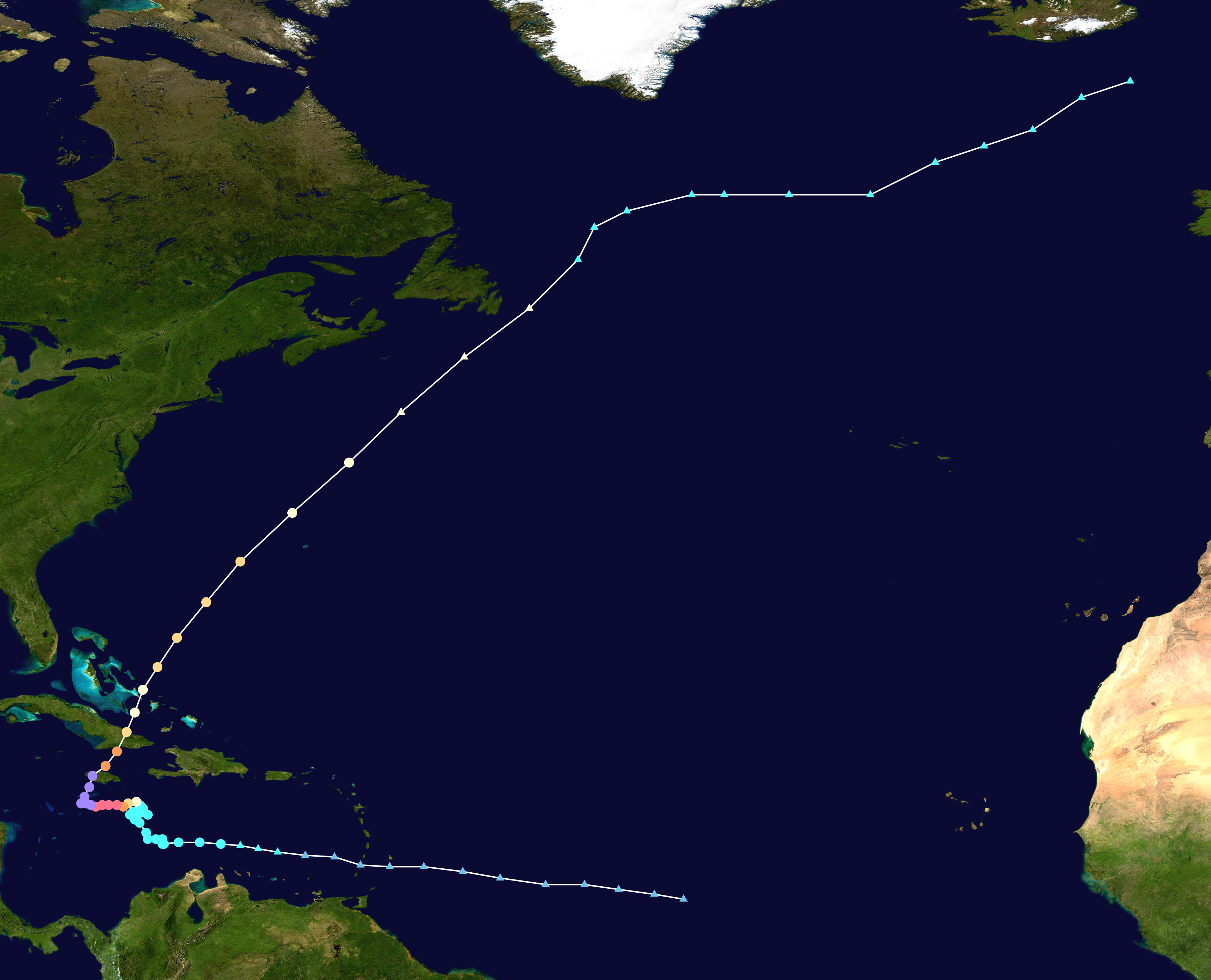
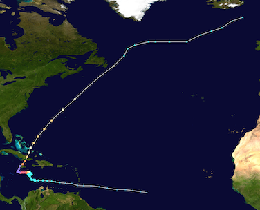
Track and intensity of Major Hurricane MELISSA (left), source:
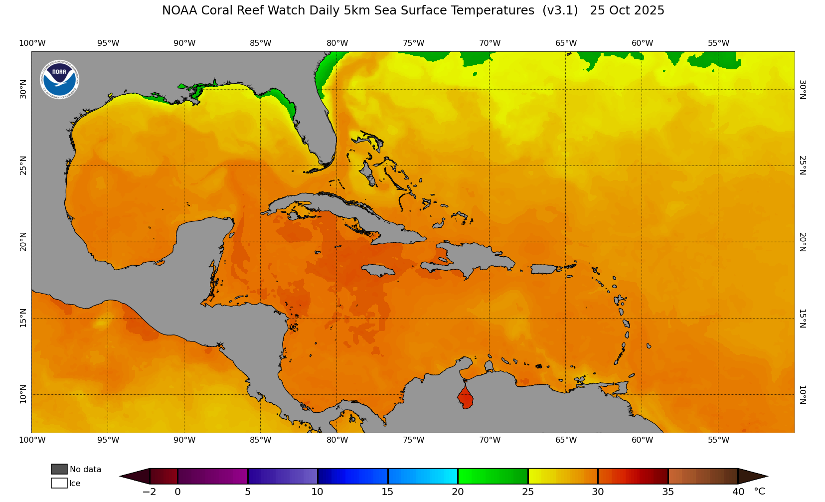
NASA, and SSTs over the Caribbean ahead of the formation of Major Hurricane MELISSA, 25.10.2025 (right), source:
NOAA Coralreefwatch
|
 |
 |
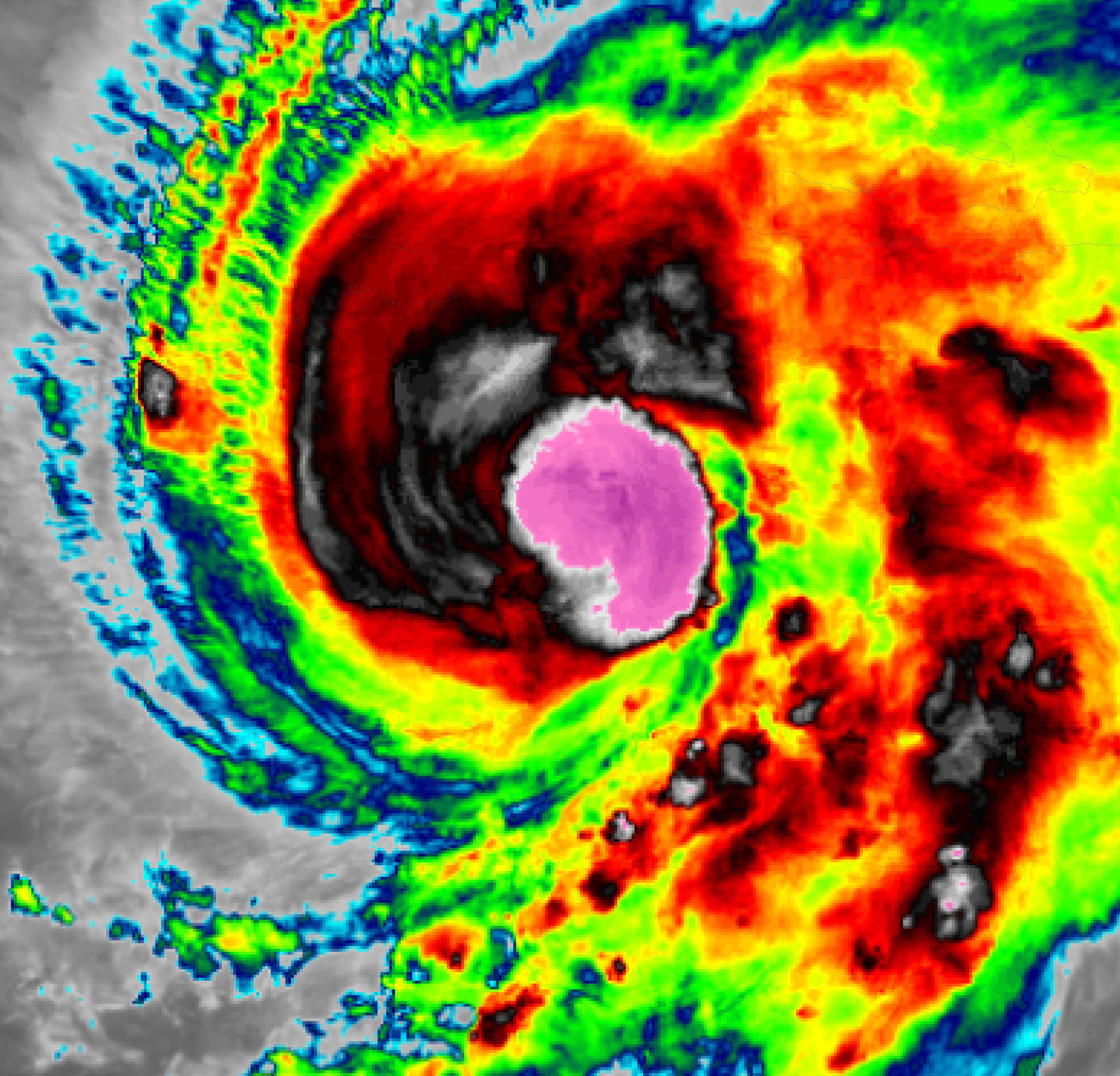
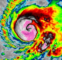
Without the impeding westerly shear, Hurricane MELISSA rapidly strengthened over the very warm waters of the Caribbean. SSTs reached around 30 °C south of Jamaica ahead of the arrival of Hurricane MELISSA. Within 8 h of attaining hurricane strength, MELISSA had reached major hurricane strength on October 26, 2025, 03 UTC. Major Hurricane MELISSA continued to track slowly to the west with forward speeds of only 5 kph. On October 26, 2025, MELISSA continued to intensify. By 09 UTC, Hurricane MELISSA reached category 5 with sustained winds of up to 260 kph and a central pressure of 917 hPa. The 24 h intensification rates peaked on October 26, 2025, at 18 UTC with a 24 h increase of the sustained winds of 100 kph. At the same time, the central pressure of Hurricane MELISSA dropped by 34 hPa/24 h.
|
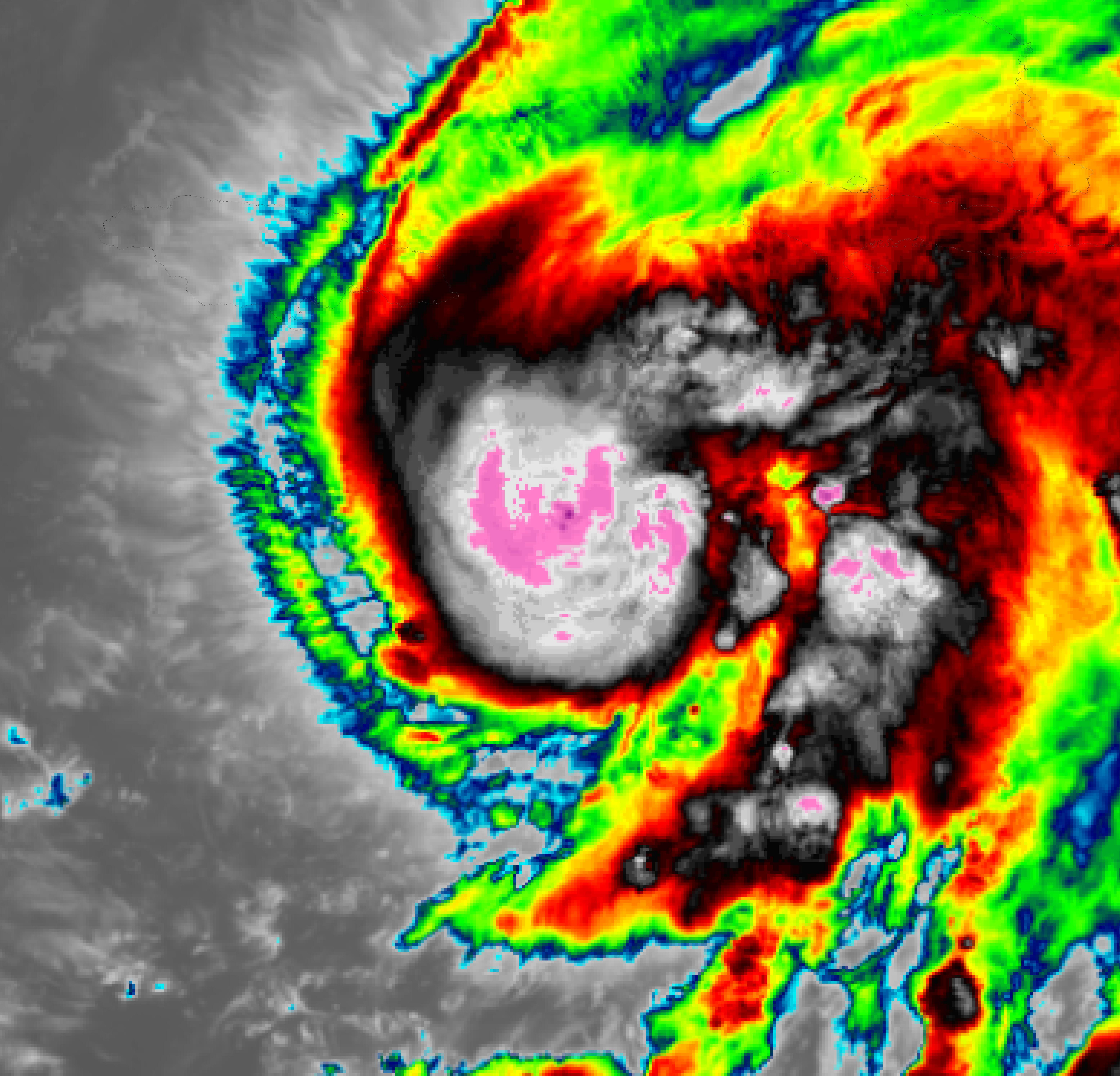
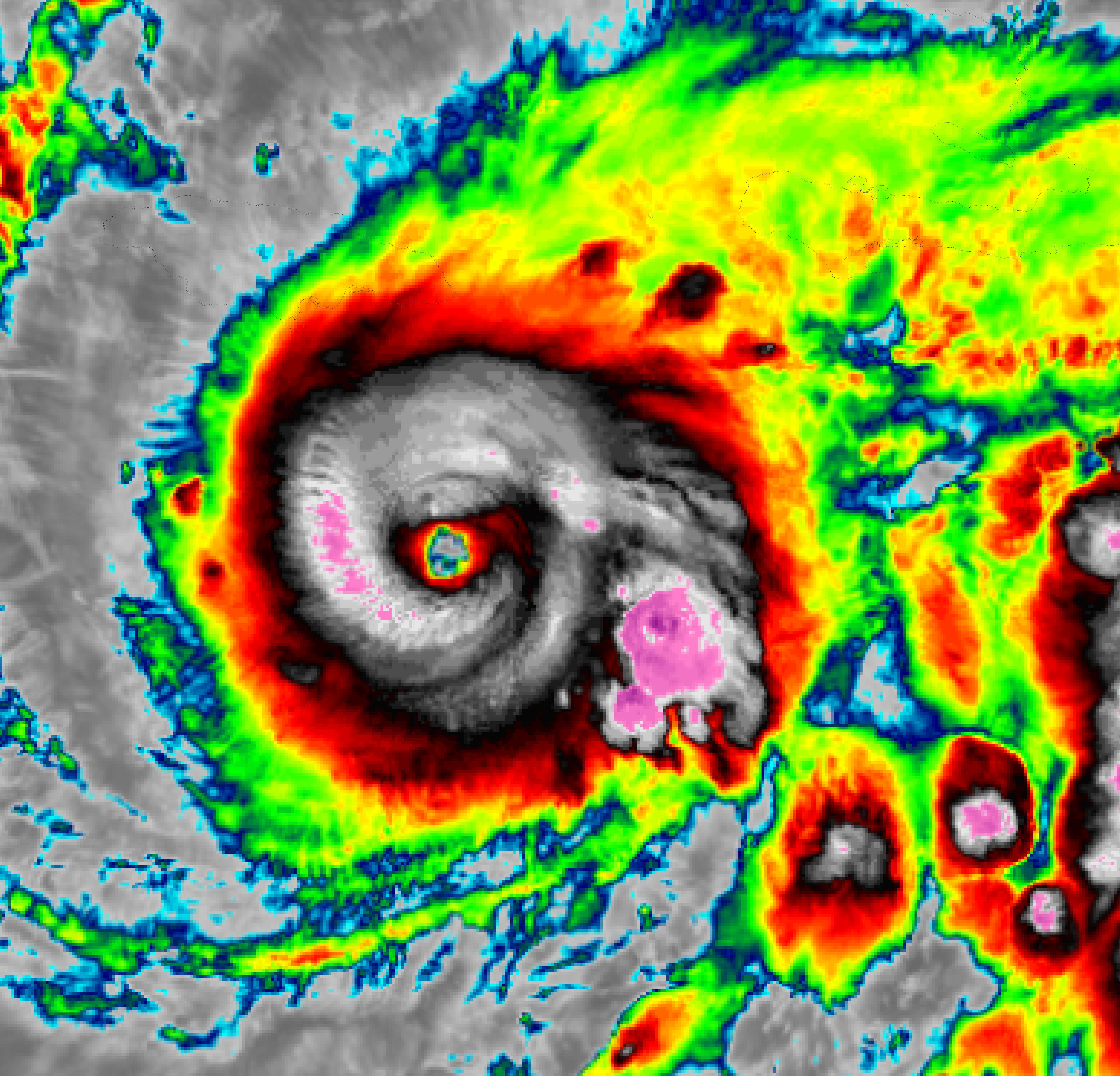
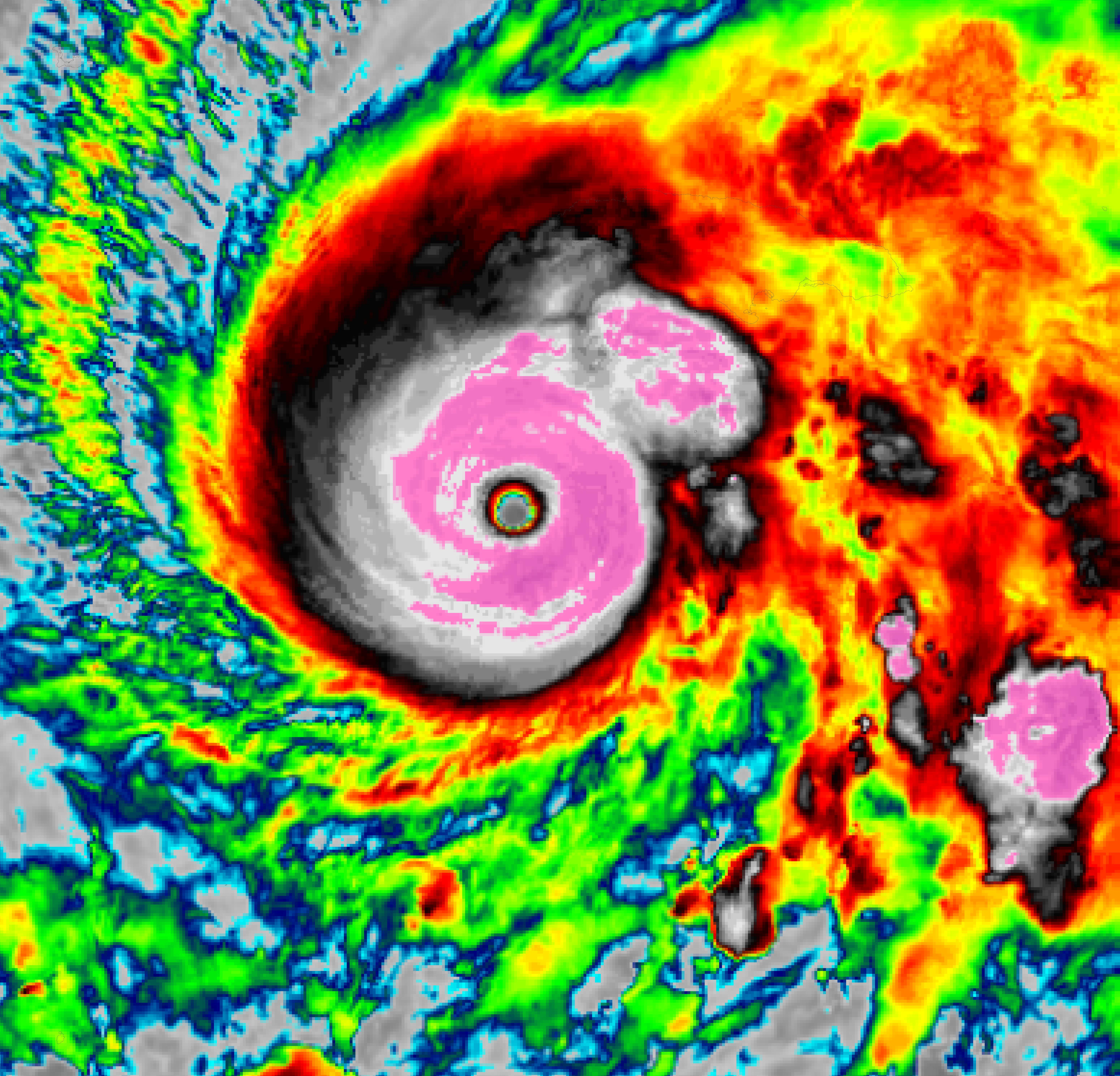
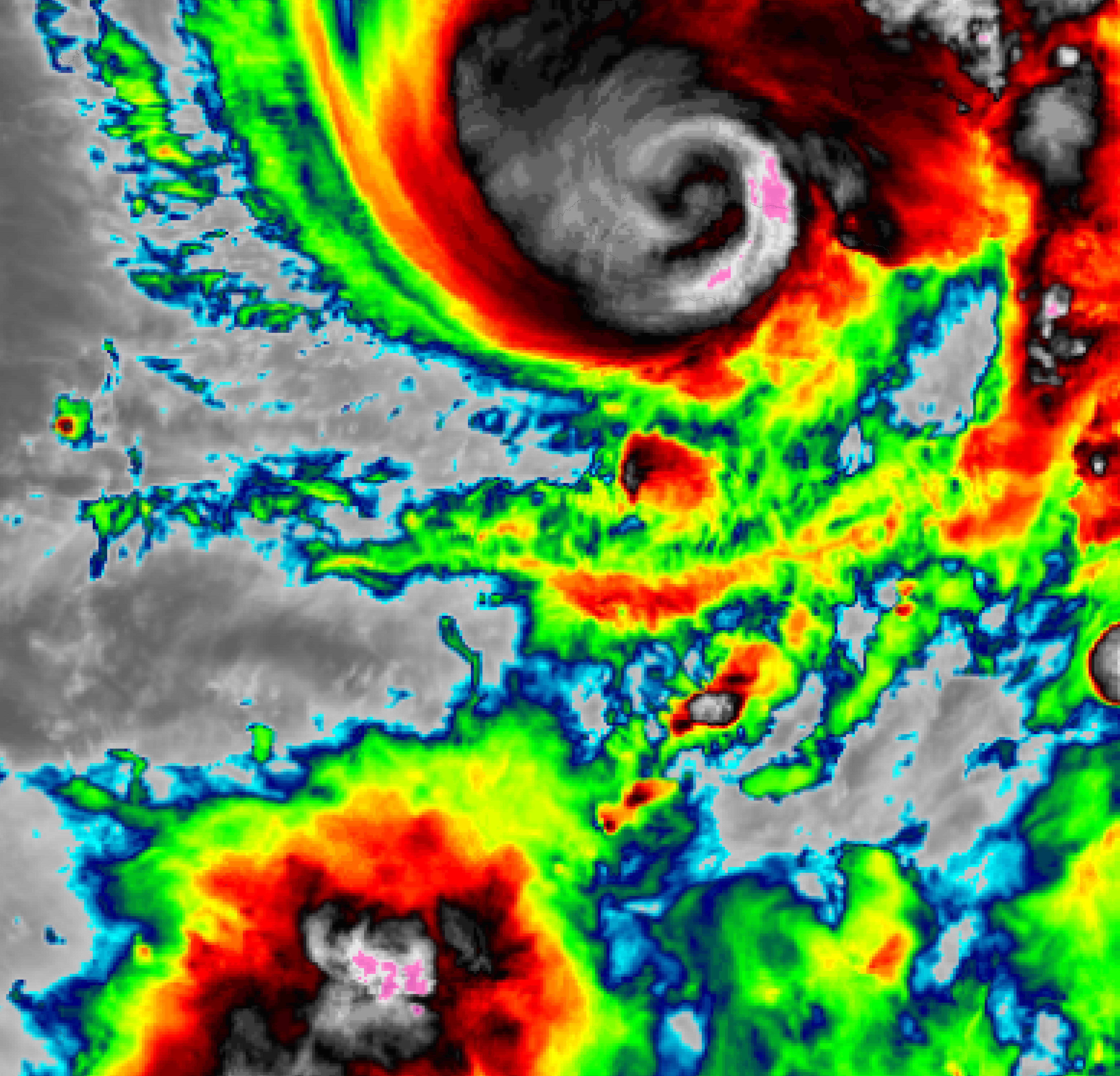
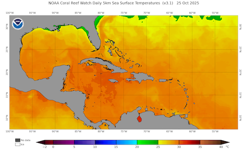
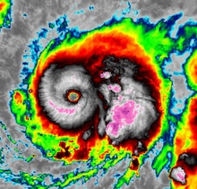
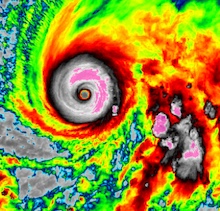
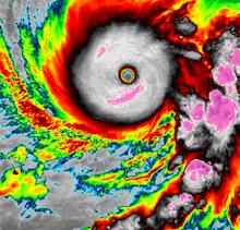
3 h infrared satellite imagery of the rapid intensification of Major Hurricane MELISSA from a tropical storm to a category 4 hurricane southeast of Jamaica, 25.10.2025 12 UTC - 26.10.2025 12 UTC, source:
NASA Worldview
|
 |
 |
 |
 |
 |
 |
 |
 |
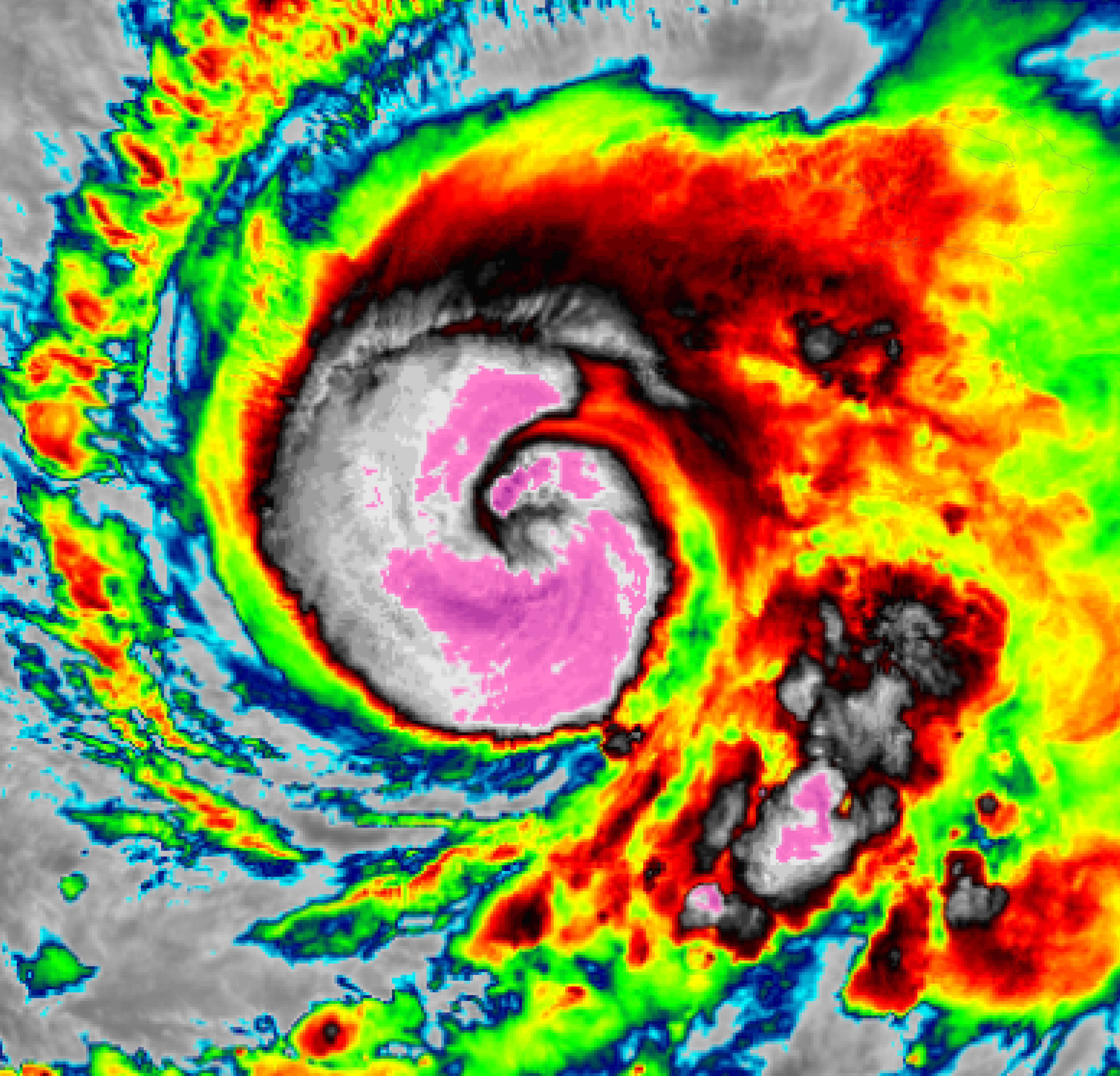
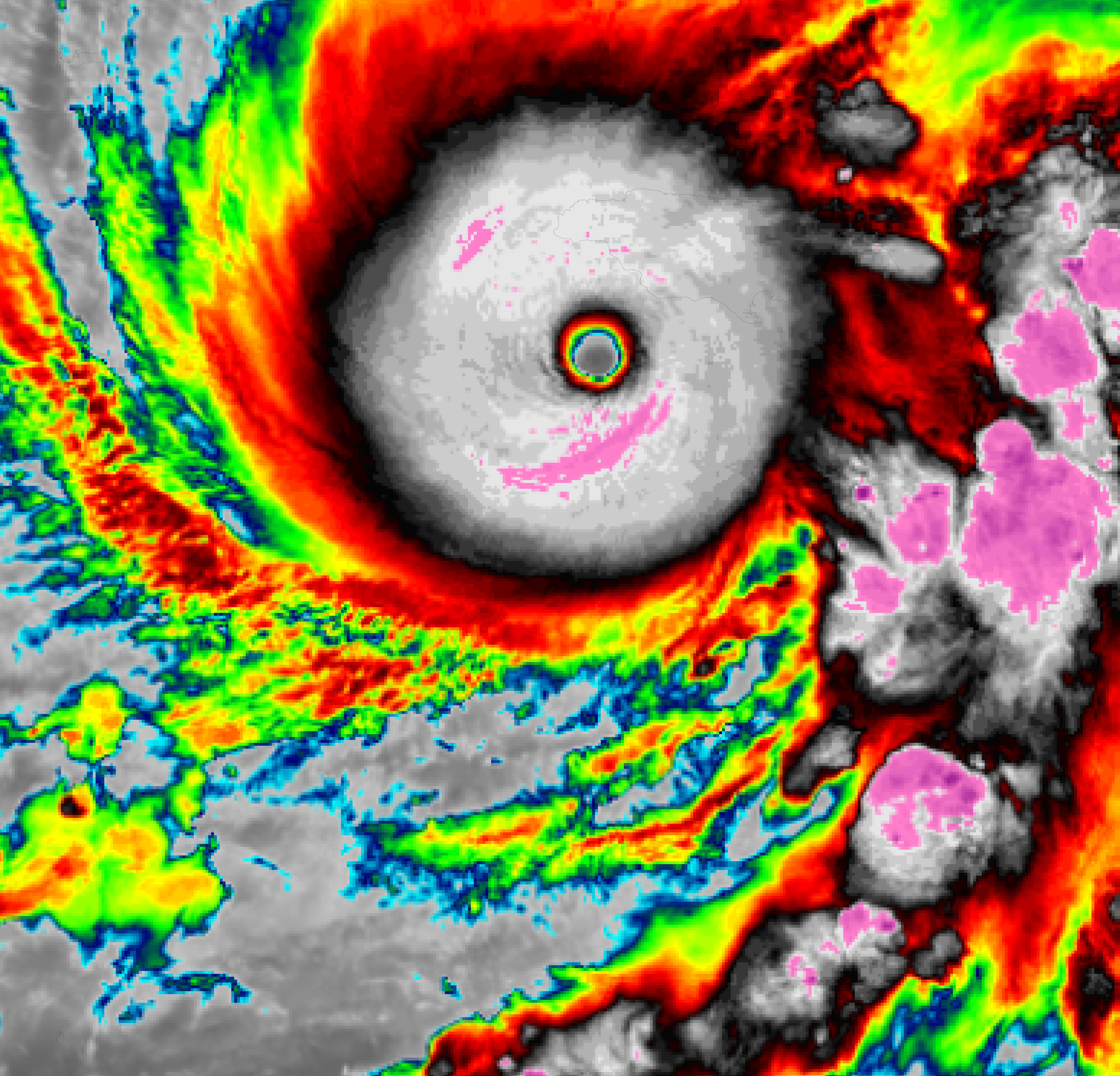
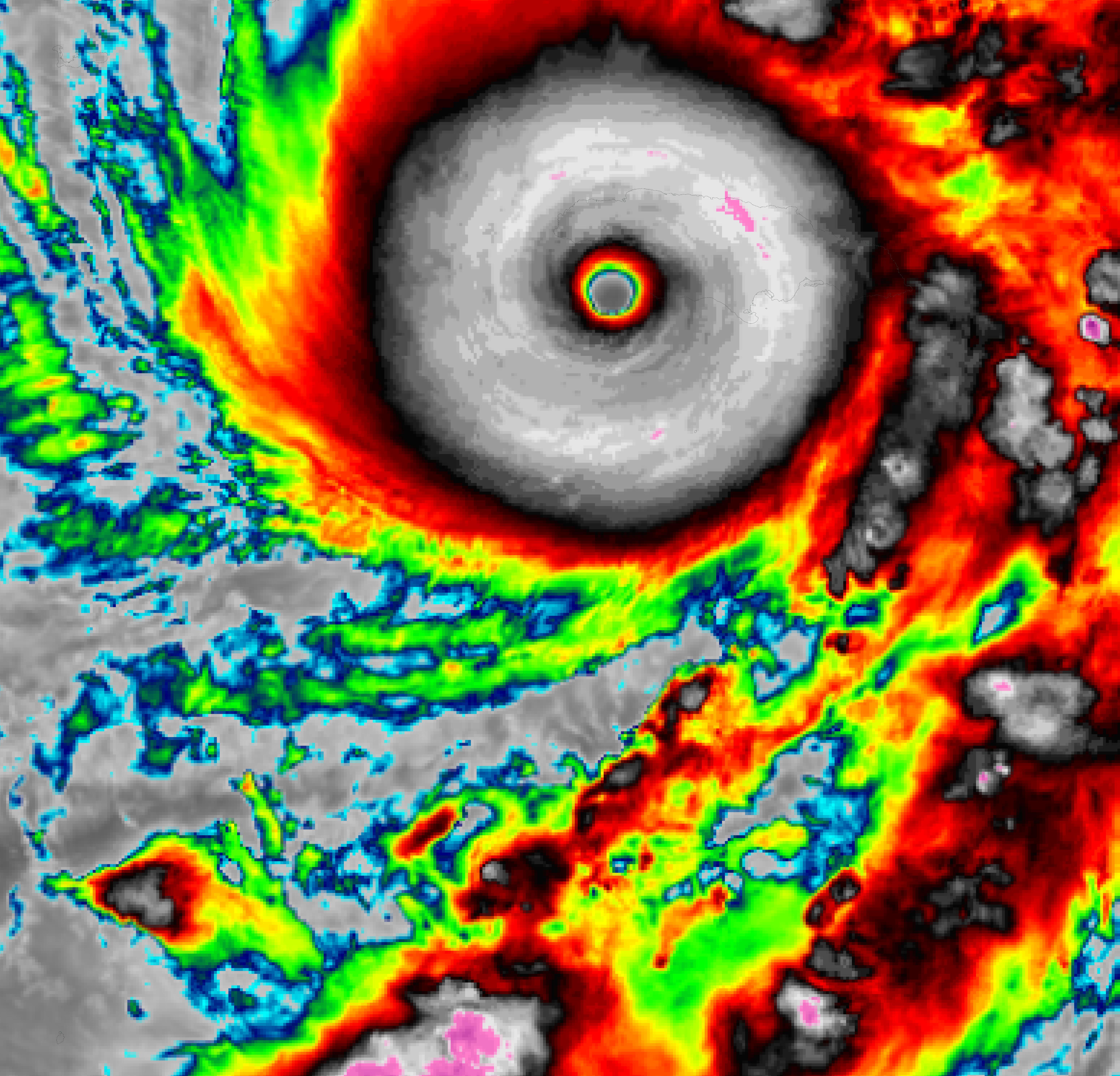
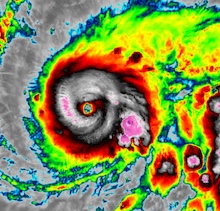
On October 27, 2025, MELISSA continued to slowly creep westwards under further intensification. From the night of October 27, 2025, Hurricane MELISSA came under the influence of a mid-level trough located over the Southeastern US. Subsequently, the hurricane made a sharp turn to the northeast, which aimed MELISSA directly at Jamaica. On October 28, 2025, MELISSA continued to intensify despite already being a powerful Category 5 hurricane. Further strengthening of Hurricane MELISSA was aided by upper-level divergence above the hurricane. In addition, the ocean heat content was very large south of Jamaica with SSTs of more than 28 °C reaching dozens of meters deep in this part of the Caribbean.
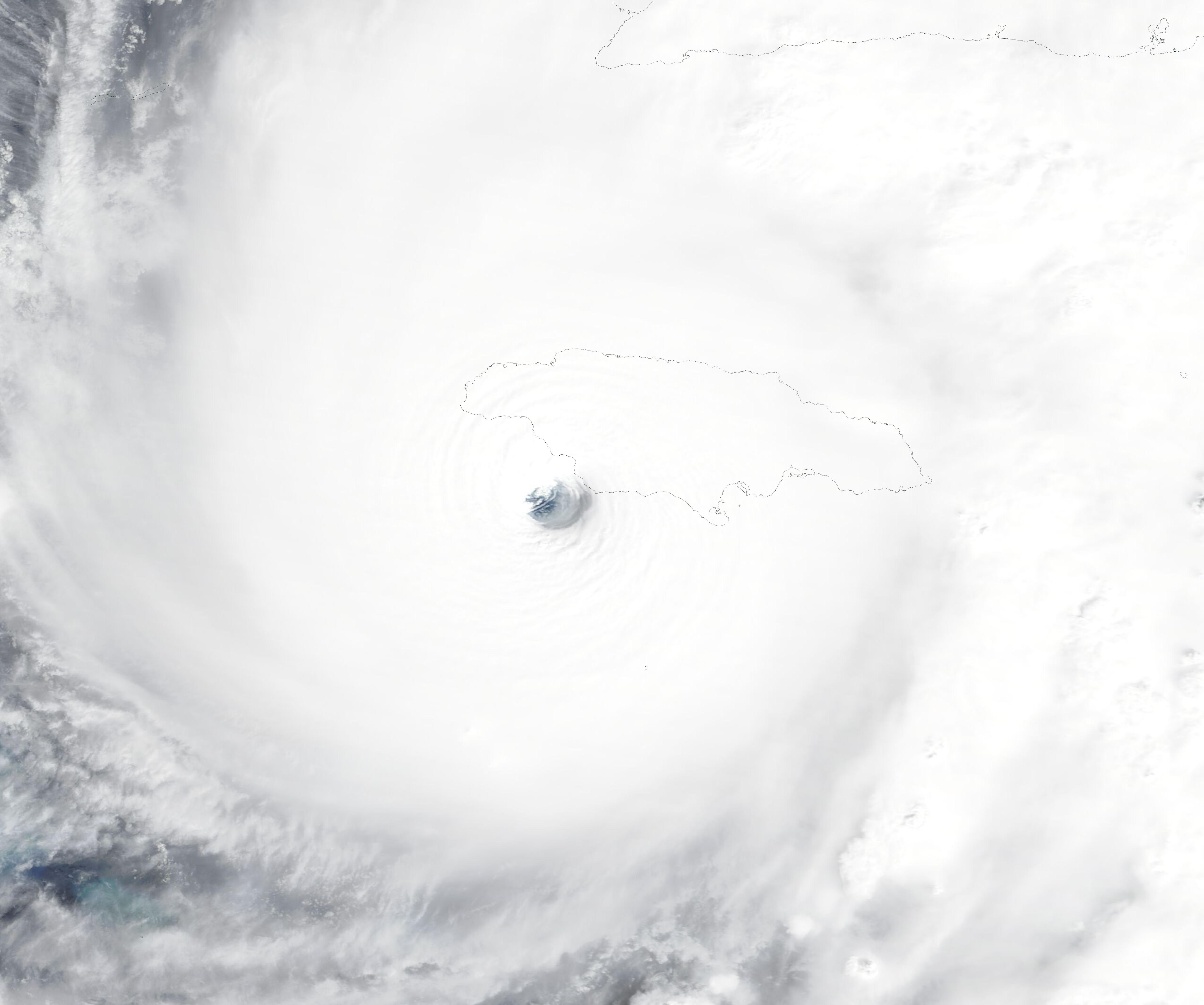
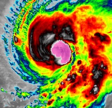
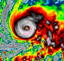
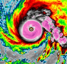
By midday on October 28, 2025, the sustained winds of Major Hurricane MELISSA reached more than 280 kph. The 13 UTC reconnaissance flight of the Hurricane Hunters confirmed that the central pressure of Hurricane MELISSA had dropped below 900 hPa. This makes MELISSA only the seventh hurricane in the Atlantic Basin to achieve a sub-900 hPa central pressure. In the final hours before landfall, Hurricane MELISSA continued to intensify into a high-end category 5 hurricane. The remarkable satellite display of Hurricane MELISSA is close to the perfect storm that is feasible in the Atlantic Basin. The 15 km wide eye was nearly circular with a nearly uniform eye wall.
|
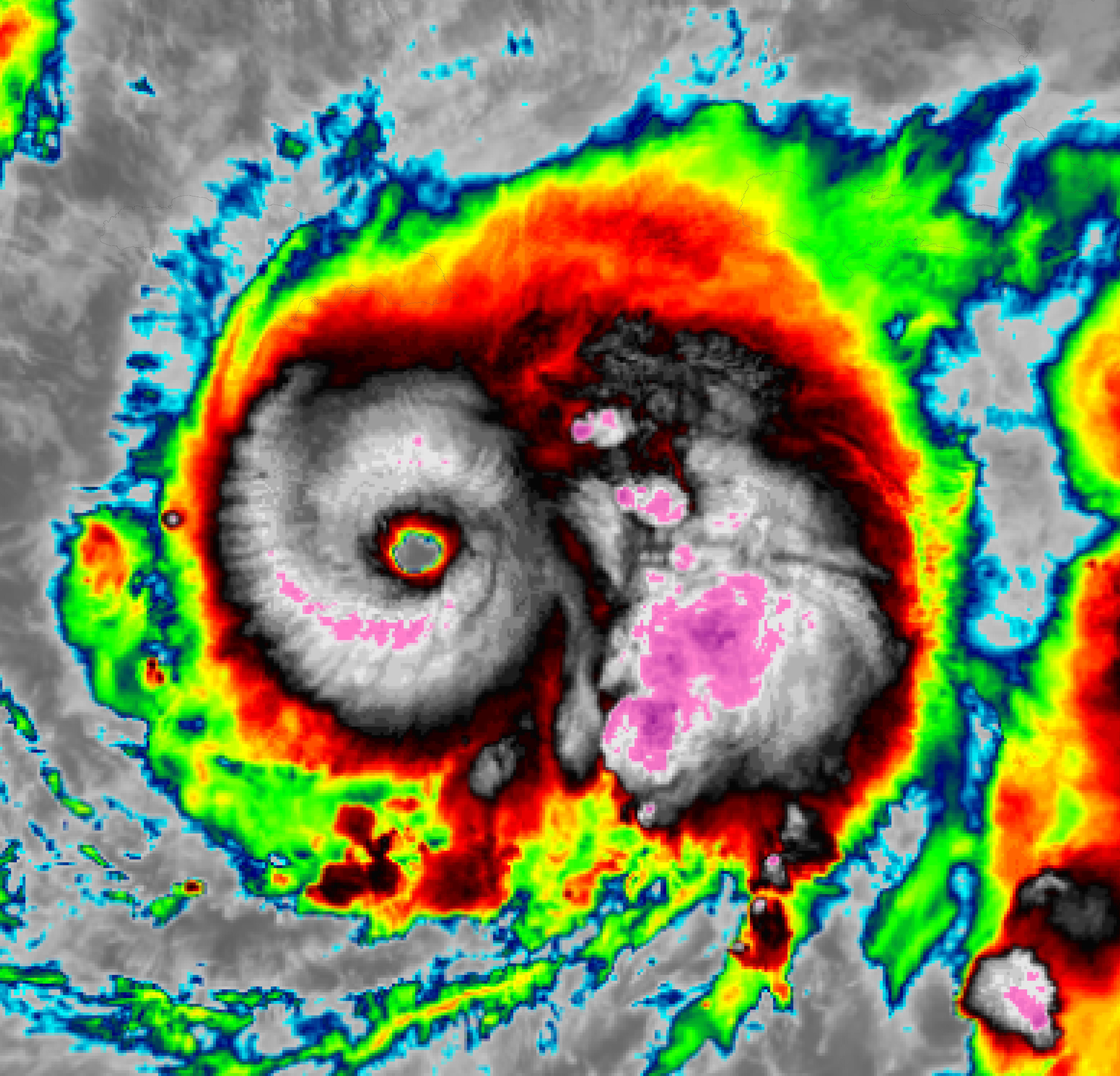
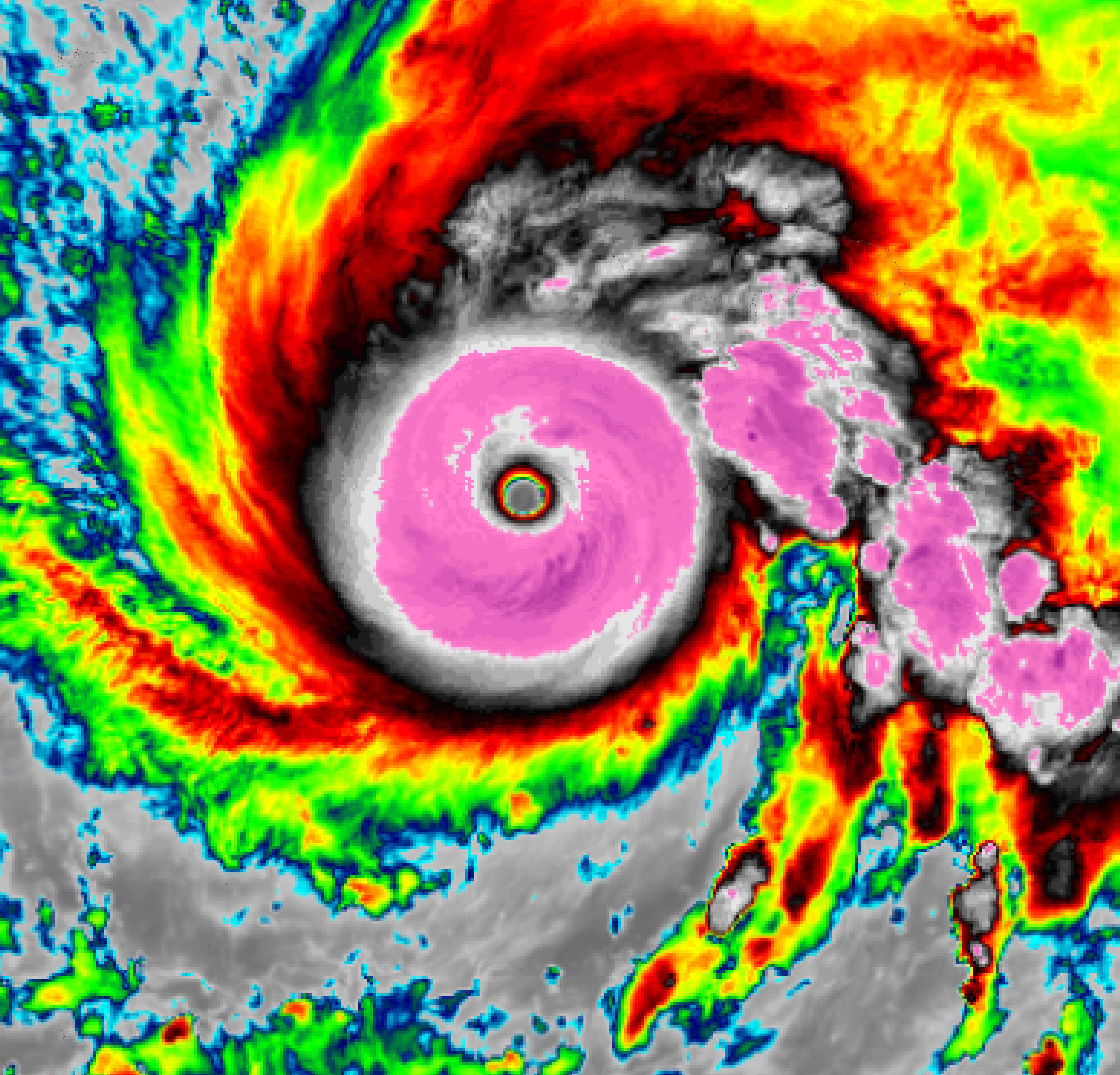
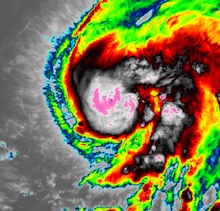
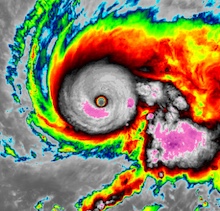
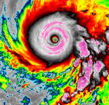
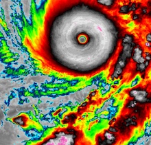
3 h infrared satellite imagery of the intensification of Hurricane MELISSA at category 5, 27.10.2025 12 UTC - 21 UTC, source:
NASA Worldview
|
 |
 |
 |
 |
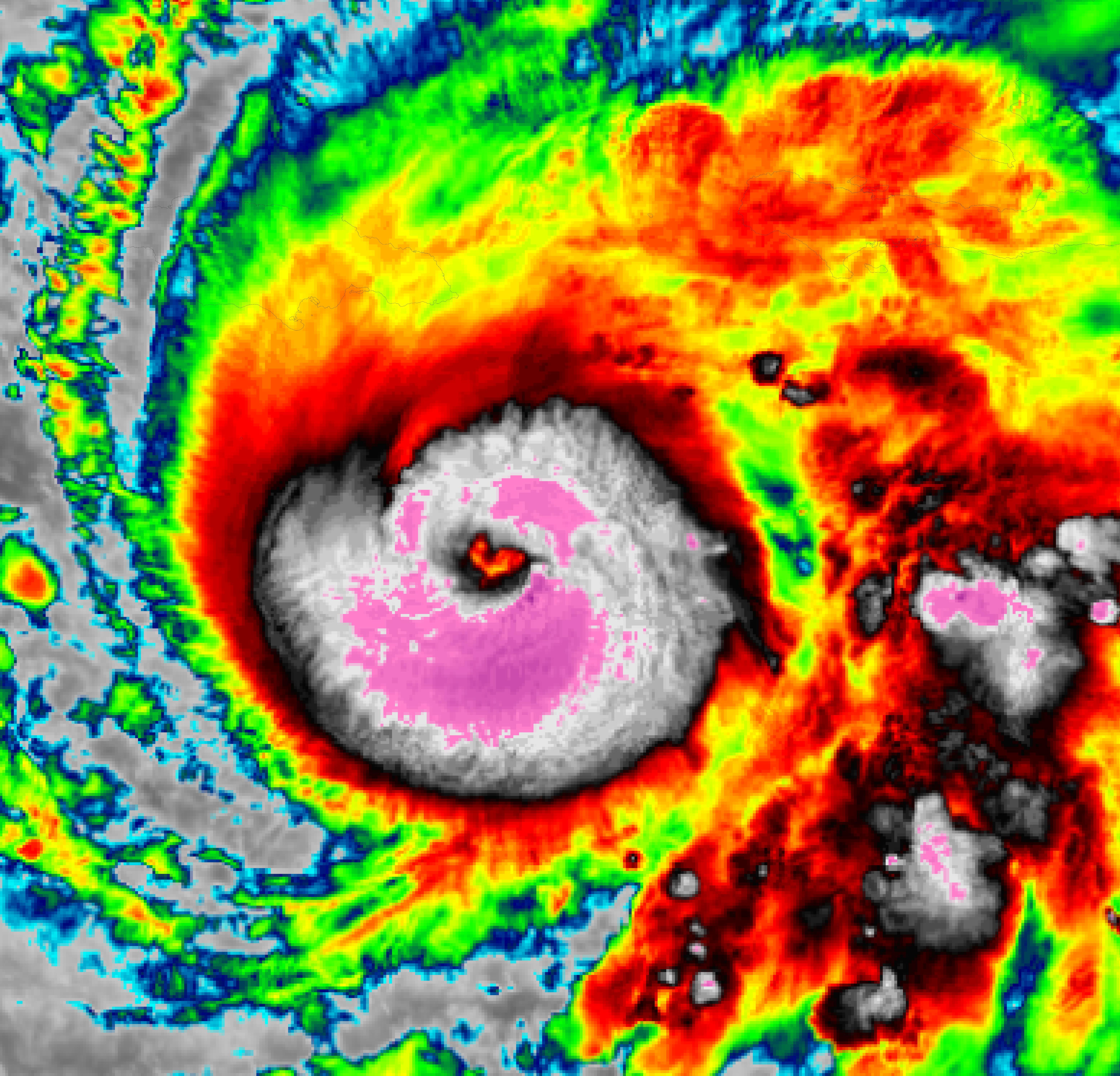
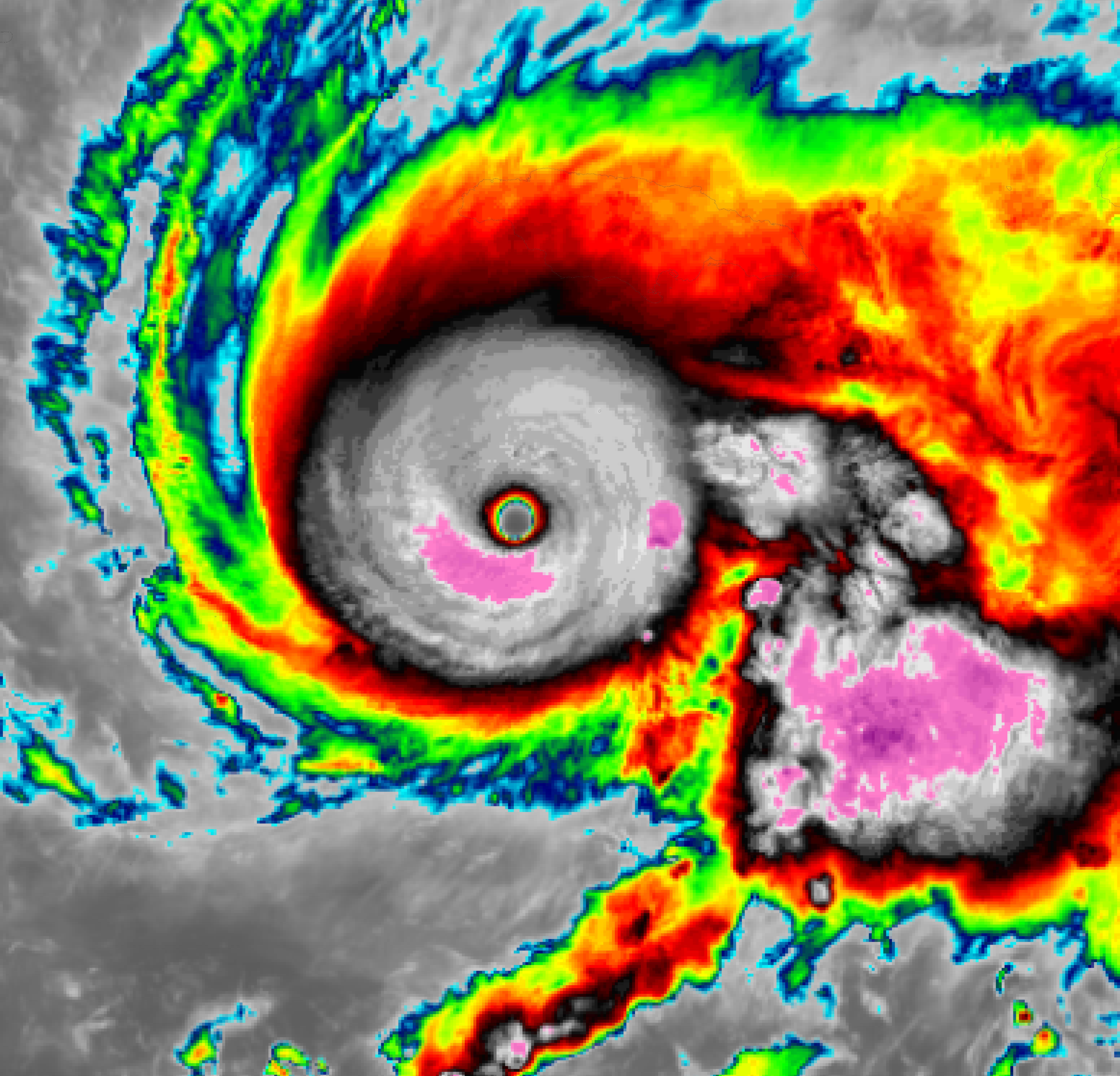
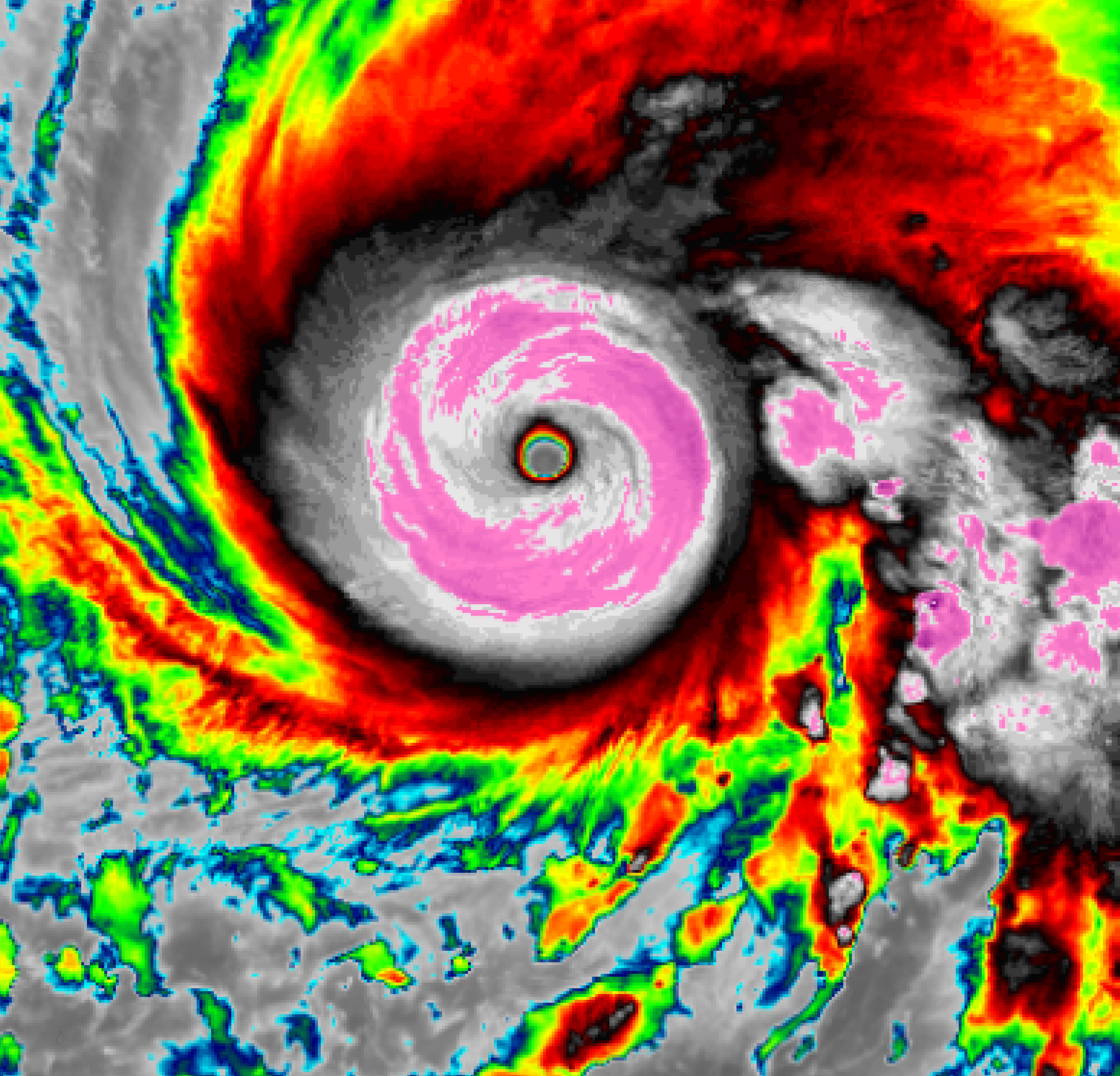
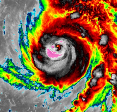
By 14 UTC, the sustained winds of Major Hurricane MELISSA had reached 295 kph. These are the tied second-highest sustained winds ever reported for a hurricane in the Atlantic Basin (equal to Hurricane WILMA in 2005). The central pressure of MELISSA dropped to 892 hPa, which is the tied third lowest pressure ever observed in the Atlantic Basin. In the following two hours, Major Hurricane MELISSA retained its intensity and made landfall on Jamaica near New Hope in the western part of the island at around 17 UTC. Hurricane MELISSA became the tied strongest hurricane to make landfall in the Atlantic Basin with sustained winds of 295 kph and a central pressure of 892 hPa. The only other Atlantic hurricane with similar landfalling strength is the 1935 Labor Day Hurricane, which made landfall in the Florida Keys in September 1935. Hurricane DORIAN had similar sustained winds of 295 kph during its landfall in the Northern Bahamas, but the central pressure was considerably higher at 910 hPa.
|
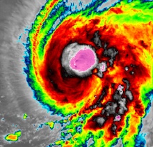
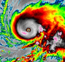
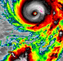
3 h infrared satellite imagery of the intensification of Major Hurricane MELISSA to the third most intense Atlantic hurricane during the approach on Jamaica, 28.10.2025 00 UTC - 21 UTC, source:
NASA Worldview
|
 |
 |
 |
 |
 |
 |
 |
 |
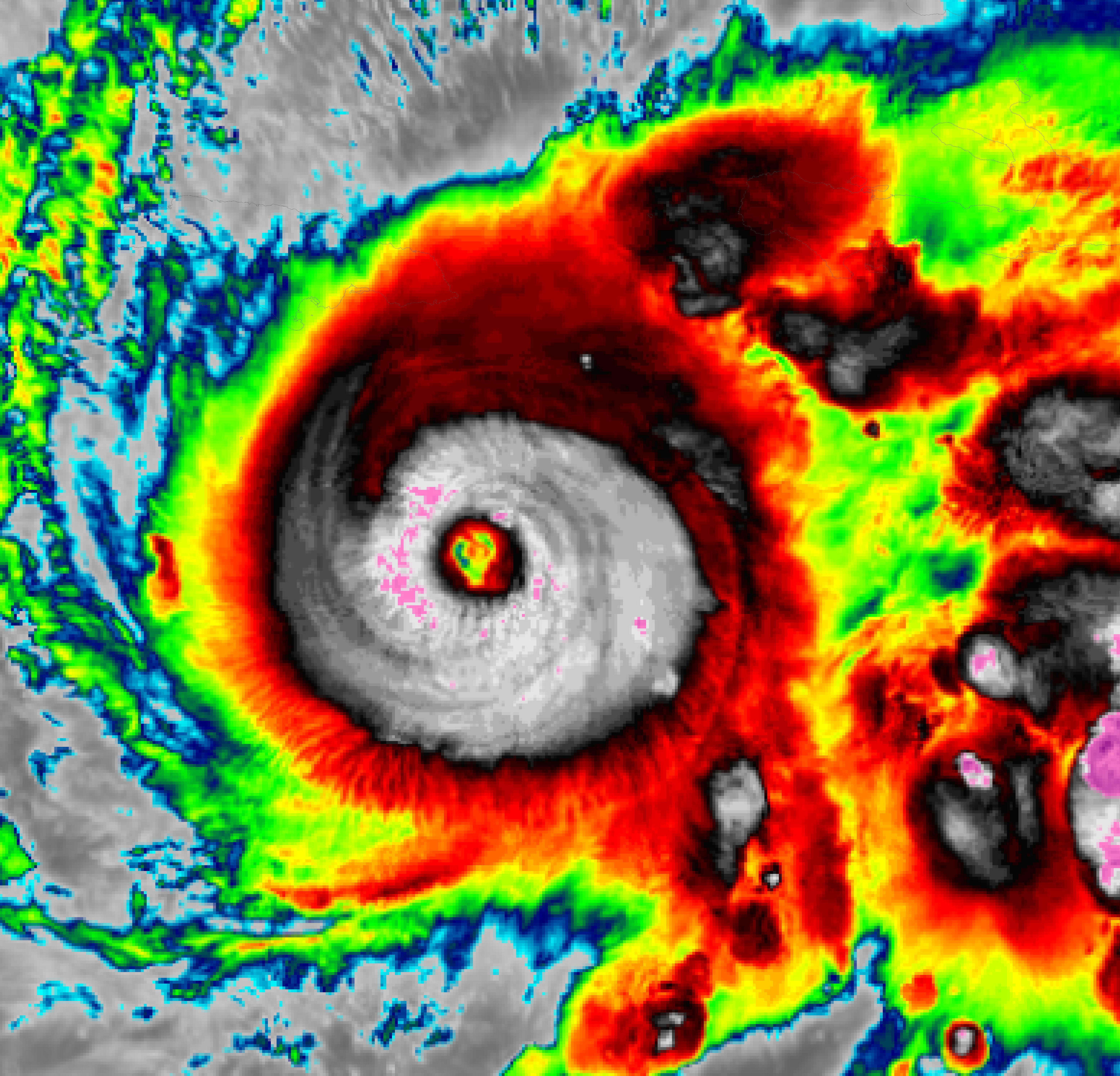
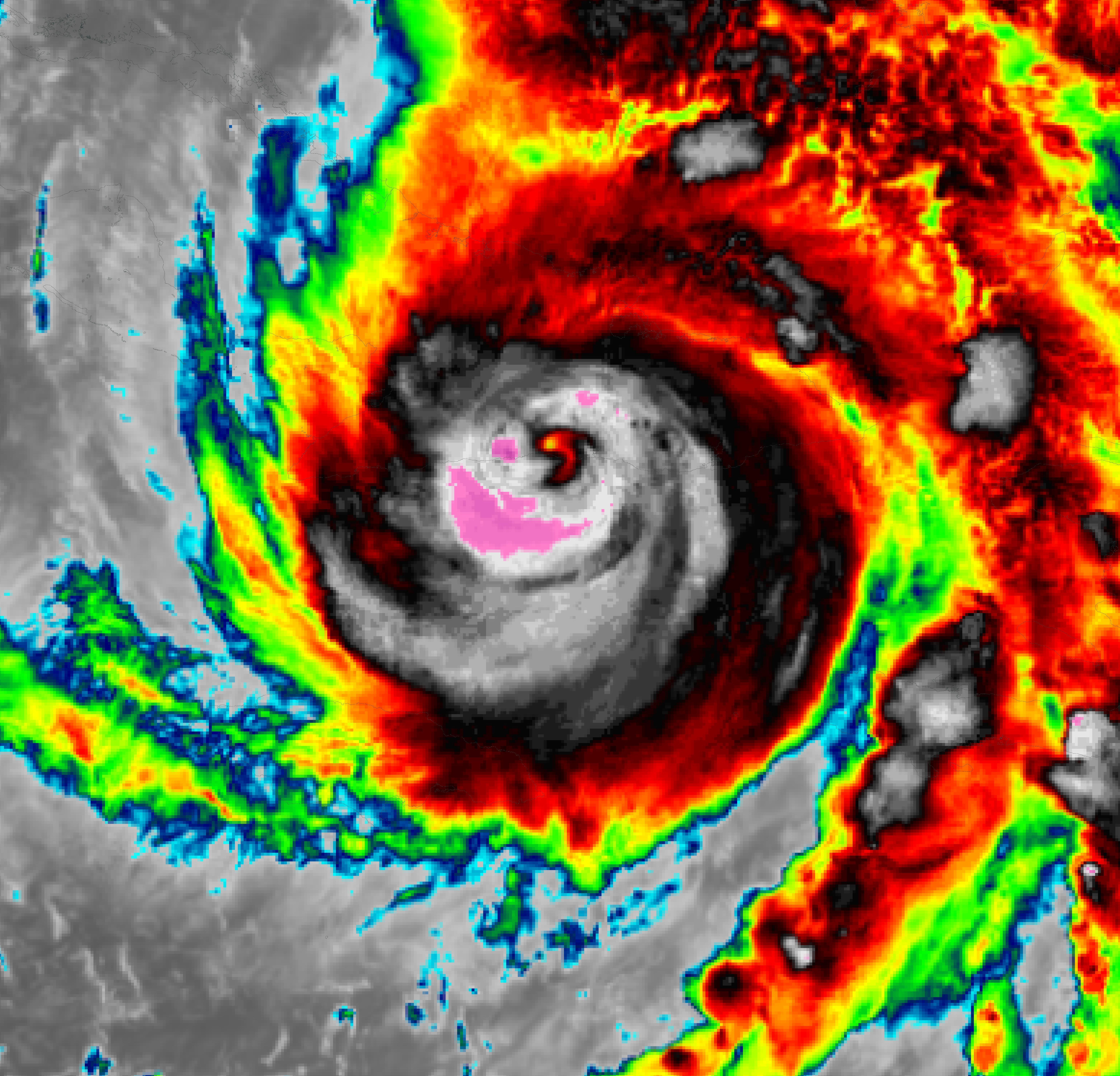
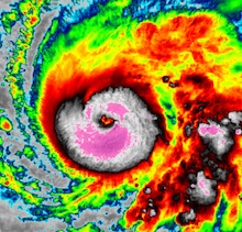
Late on October 28, 2025, Hurricane MELISSA had traversed Jamaica. Despite the landfall in Jamaica, Hurricane MELISSA retained major hurricane strength. Over land, Hurricane MELISSA retained category 5 strength for more than 2 h. By 00 UTC on October 29, 2025, the intensity of Hurricane MELISSA bottomed with sustained winds of 205 kph and a central pressure 950 hPa. Crossing the Cayman Trench, MELISSA shortly intensified to reattain category 4 strength. Due to the growing influence of the upper-level steering trough over the Southeastern US, the forward speeds of Hurricane MELISSA increased considerably. At 07:10 UTC on October 29, 2025, Hurricane MELISSA made landfall in Cuba east of Chivirico in the province of Santiago de Cuba. Upon landfall, MELISSA had sustained winds of 195 kph and a central pressure of 952 hPa.
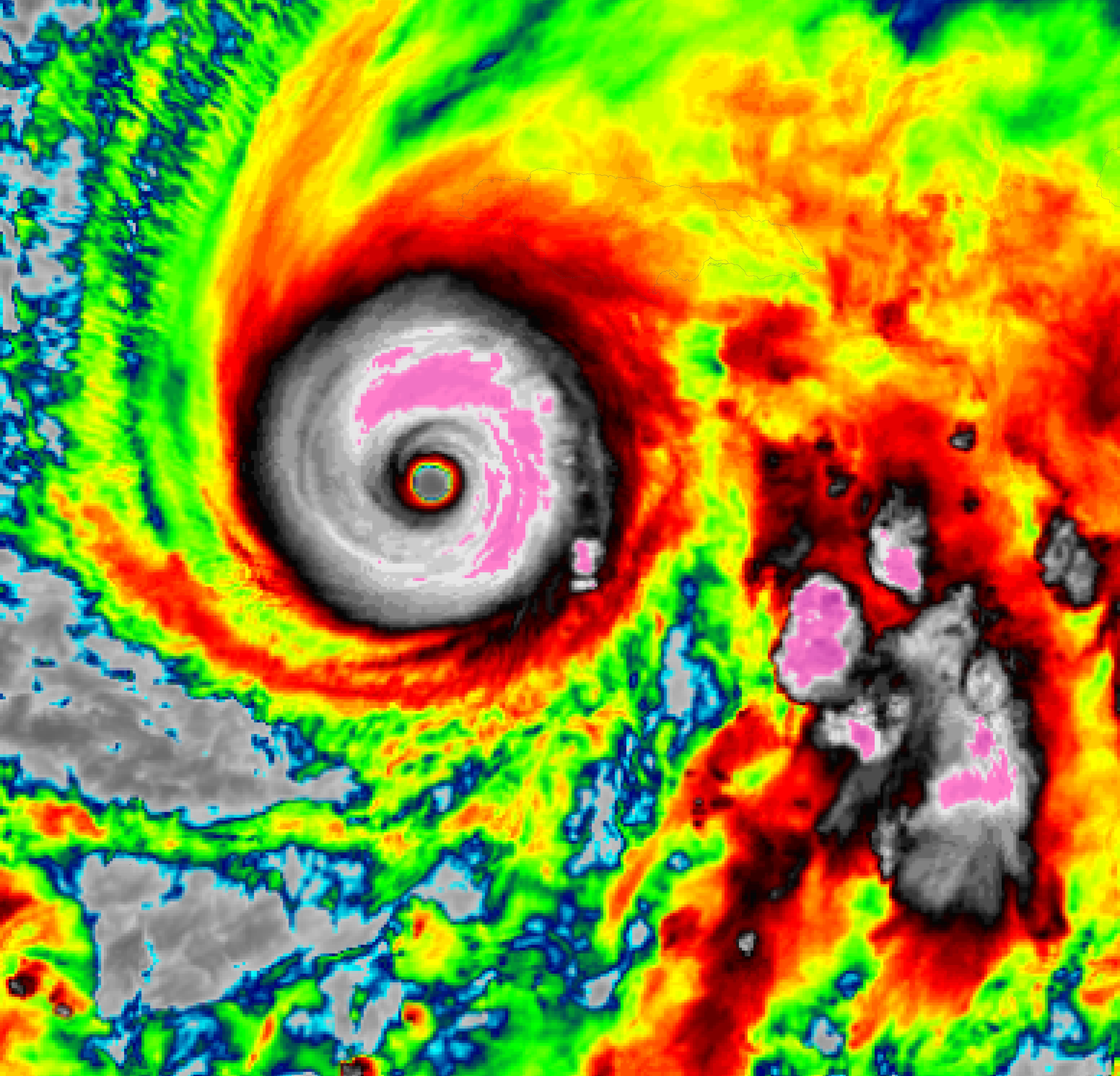
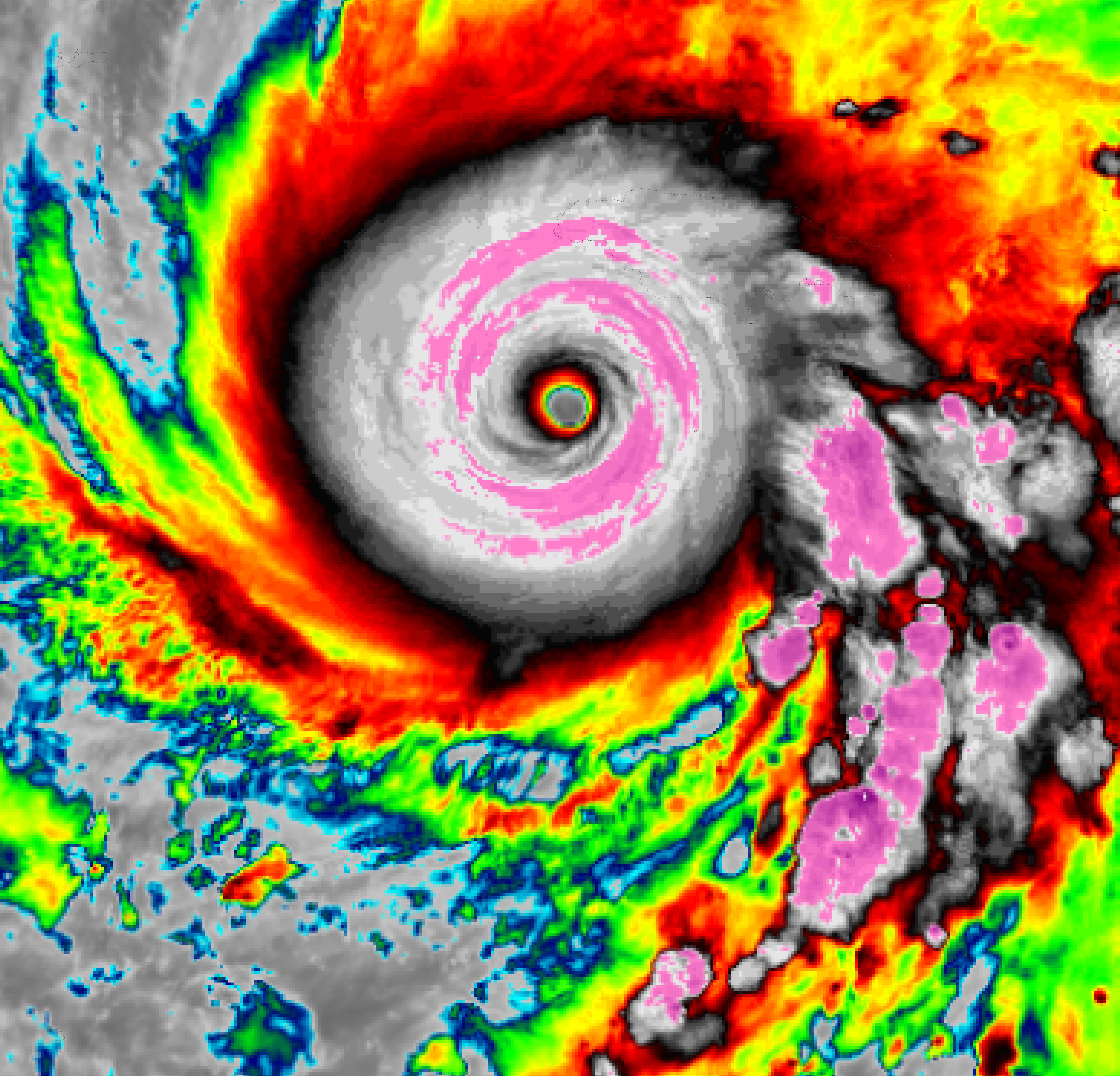
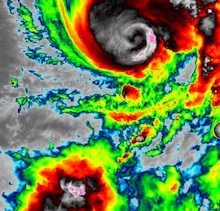
Infrared satellite imagery of Major Hurricane MELISSA as a category 3 hurricane
at landfall in Cuba, 29.10.2025 07:10 UTC, source:
NASA Worldview
|
 |
Following the traverse of Cuba, Hurricane MELISSA briefly weakened to a category 1 hurricane. Upon landfall in the Southern Bahamas late on October 29, 2025, sustained winds dropped to 150 kph and the central pressure rose to 974 hPa. In the Bahamas, wind gusts of up to 158 kph were reported. On October 30, 2025, the forward speed of Hurricane MELISSA increased rapidly due to the approaching upper-level trough. The hurricane was slingshot to the northeast ahead of the trough. Over the open ocean, MELISSA intensified for a third time to a Category 2 hurricane. Sustained winds reached up to 165 kph, and the central pressure dropped to 964 hPa again. Early on October 31, 2025, the outer bands of Hurricane MELISSA impacted the Bermudas. Later on that day, MELISSA underwent extratropical transition and became a powerful extratropical low. As an extratropical low, MELISSA brought high winds and heavy rains to Newfoundland on November 01, 2025.
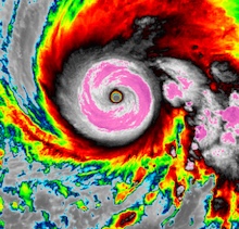
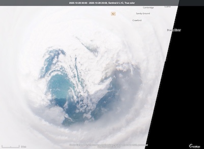
Sentinel-2 satellite imagery of Major Hurricane MELISSA prior to becoming the most
powerful landfalling hurricane in the Atlantic Basin during the satellite era. The
satellite imagery shows the nearly perfectly circular eye with powerful mesovortices.
In the eye, the calm seas of the Caribbean are visible, 28.10.2025,
source:
Copernicus Browser
|
 |
Before its landfall in Jamaica, Hurricane MELISSA was among the most powerful tropical cyclones on record in the Atlantic Basin. Only two known hurricanes have a lower central pressure than Hurricane MELISSA (Hurricane WILMA in 2005 with a central pressure of 882 hPa and Hurricane GILBERT in 1988 with a central pressure of 888 hPa). The satellite presentation of Hurricane MELISSA at peak intensity was among the best to be observed in the Atlantic Basin. Dvorak ratings of more than T8.0 signal the near immaculate structure of Hurricane MELISSA. Current generation satellites have never observed any tropical cyclones with such a dry eye as Hurricane MELISSA. In contrast to Hurricane WILMA and Hurricane GILBERT, Hurricane MELISSA had no pinhole eye near peak intensity. Likely, this is attributed to the fact that the rapid intensification cycle of Hurricane MELISSA had finished, and MELISSA reached peak intensity during a gradual intensification to a high-end category 5 hurricane. Hurricane MELISSA is among the hurricanes with the longest sustained category 5 intensity, with 34 h of continuous category 5 intensity. This prolonged period of sustained category 5 intensity was fueled by the fact that Hurricane MELISSA never underwent an eye wall replacement cycle at category 5. Typically, such high-end hurricanes undergo an eye wall replacement cycle where a secondary outer eye wall forms and deprives the inner eye wall of moisture and momentum. The inner eye wall ceases while the eye expands, and the outer eye wall intensifies.
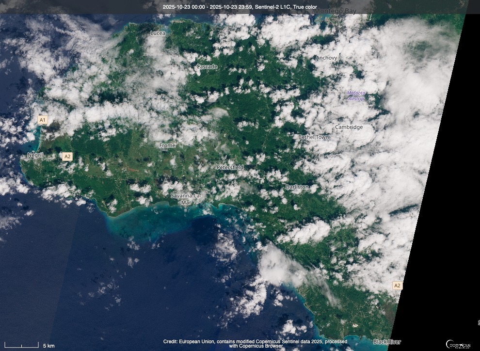
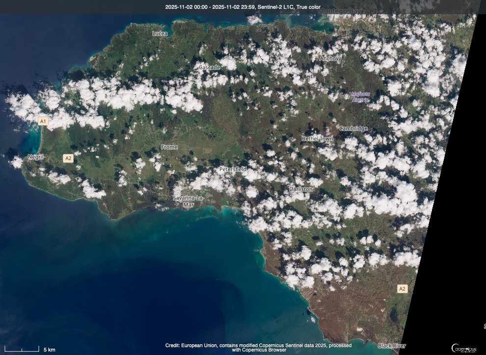
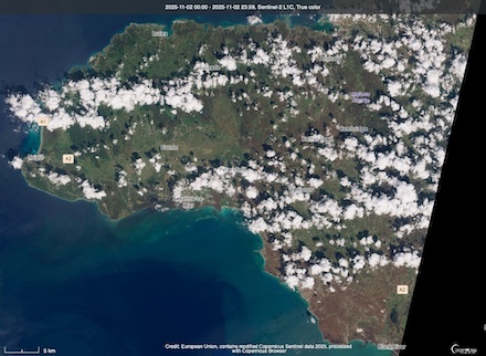
Sentinel-2 satellite imagery Western Jamaica showing the lush green tropical vegetation prior to the landfall of Hurricane MELISSA, 23.10.2025 (left), and after the passage of Hurricane MELISSA showing the widespread damage to the vegetation of the island, 02.11.2025 (right). Brown colors indicate the widespread defoilage of trees and plants in Western Jamica,
source:
Copernicus Browser
|
 |
 |
The lack of an eye wall replacement cycle prevented any weakening of Hurricane MELISSA before its landfall in Jamaica. Upon landfall, Hurricane MELISSA became the most powerful tropical cyclone to ever make landfall in Jamaica. The previous record of Hurricane GILBERT was surpassed by a large margin. Hurricane GILBERT made landfall as a low-end Category 4 hurricane in Jamaica in September 1988. Upon landfall, the eye of Hurricane MELISSA was filled with powerful mesoscale vortices that highlight the extreme intensity of the hurricane. Over land, the sheer power of Hurricane MELISSA devastated large parts of Western Jamaica. The intensity of the winds completely defoliated trees in the southwestern provinces of Jamaica. Pictures near the landfall point in Saint Elizabeth Parish show trees partially or completely debarked. This is a very rare occurrence, only observed during the passage of the most intense tropical cyclones on the planet. The observed damage in parts of Jamaica resembles the aftermath of an EF3+ tornado. Widespread debarking of trees is typically a sign of a high-end EF3 or even EF4 equivalent wind speeds. This suggests that wind speeds reached more than 250 kph during the passage of Hurricane MELISSA on Jamaica. Even concrete-built homes were severely affected by Hurricane MELISSA.
Aircraft reconaissance pictures of Saint Elizabeth Parish on Jamaica showing the widespread defoilage of the vegetation
near the landfalling point of Hurricane MELISSA, source:
NGS NOAA
|
 |
In addition, torrential rains led to countless landslides. These landslides isolated communities in the rugged terrain of Central Jamaica. During the passage of Hurricane MELISSA, a large fraction of Jamaica lost power. In the Saint Elizabeth Parish, multiple hospitals and schools were severely damaged by Hurricane MELISSA. At least 34 deaths have been reported in Jamaica directly related to Hurricane MELISSA. Torrential rains of Hurricane MELISSA also impacted Hispaniola. More than 30 deaths in Haiti are attributed to Hurricane MELISSA. In the Dominican Republic, landslides caused problems in the fresh water supply for more than 1 million customers. In Cuba, nearly 750,000 people were evacuated prior to the arrival of Hurricane MELISSA. Around 1 million homes were damaged or destroyed during the passage of the hurricane in the southeastern part of Cuba. Parts of Cuba received up to 500 mm of rain. Guantanamo Bay was also affected by Hurricane MELISSA. The impact of Hurricane MELISSA on the Bahamas was much less severe compared to Jamaica and Cuba.
|
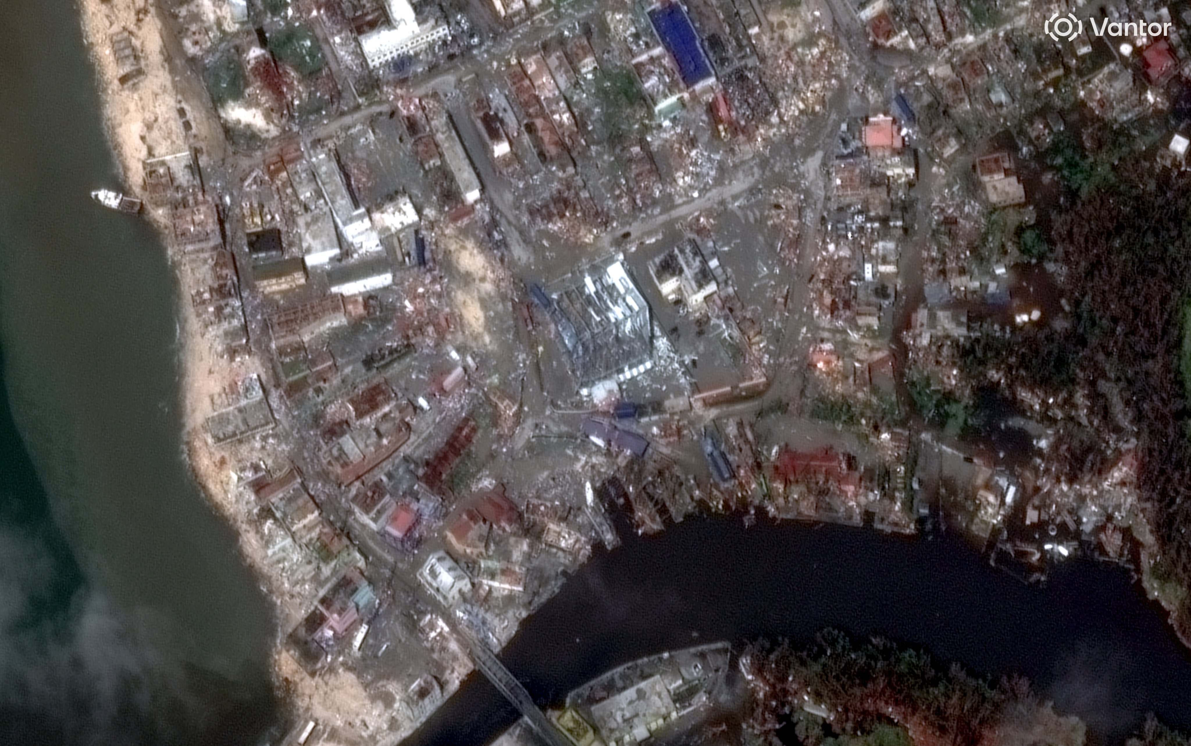
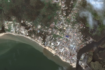
High-resolution satellite imagery of damages to residential and industrial buildings in Black River in Saint Elizabeth Parish related to Hurricane MELISSA, source:
Vantor
|
 |
 |
At the time of writing, at least 75 fatalities have been attributed to Hurricane MELISSA. Most of them are reported from Jamaica and Haiti. The death toll of Hurricane MELISSA is expected to rise further as some communities in Jamaica are still isolated. Early estimates suggest that Hurricane MELISSA caused at least 4 billion $ in damages. Post-season analysis will assess the strength of Hurricane MELISSA again. Therefore, the intensity and landfalling records of Hurricane MELISSA may change depending on the post-season analysis.
Text: KG
November 04, 2025
|