Thursday, January 23, 2025, 23:00 UTC
|

|

|

|
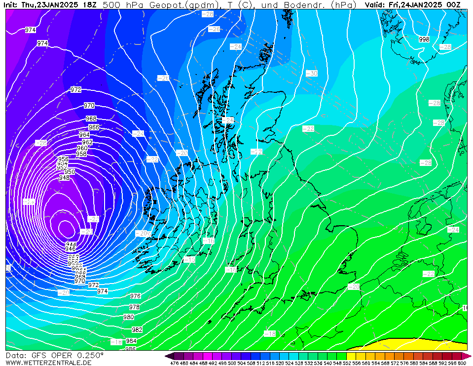
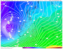
500 hPa geopotential and sea surface pressure
over the British Isles,
24.01 00 UTC
Source: wetterzentrale
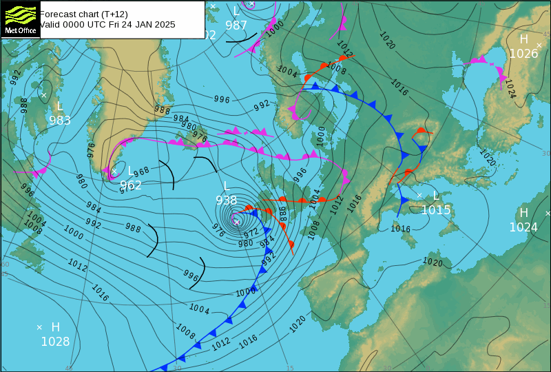
| Forecasted surface pressure field and fronts over Europe,
24.01 00 UTC
Source: UK MetOffice
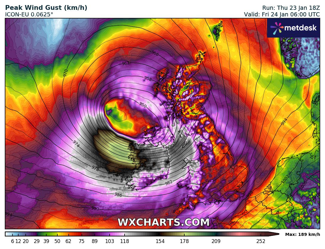
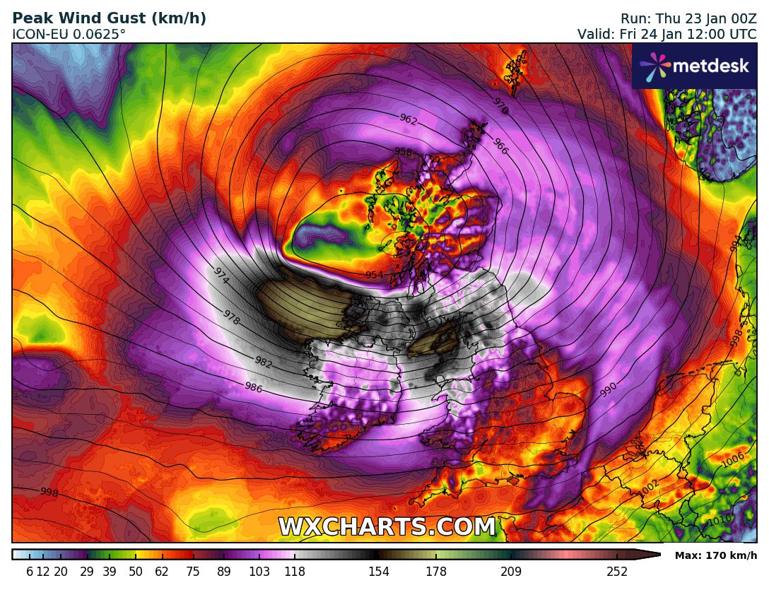
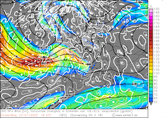
| Peak wind gusts over the British Isles,
24.01 06 UTC
Source: wxcharts
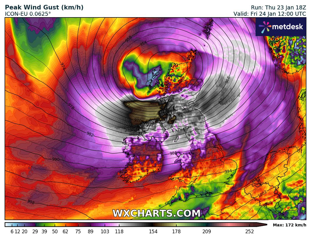
| Peak wind gusts over the British Isles,
24.01 12 UTC
Source: wxcharts
|
Wind storm
British Isles
Issued: Thursday, January 23, 2025, 23:00 UTC
After an explosive cyclogenesis, the forecasted windstorm, related to low Éowyn, may reach historic levels over Ireland. One of the strongest extratropical cyclones in recent decades is forecasted to impact the British Isles on Friday, January 24, 2025. Widespread hurricane-force wind gusts over Ireland and Great Britain are forecasted. At exposed locations, wind gusts of more than 150 kph are likely. Along the Irish Coast on the Atlantic, extreme wind gusts of over 200 kph may occur.
23.01.2025
Storm low Éowyn crossed the jet axis of a powerful jet streak spanning across the North Atlantic throughout today, January 23, 2025. During this process, the low explosively deepened. In the past 20 h, Storm Éowyn deepened by 48 hPa from 992 hPa to 944 hPa according to aircraft reconnaissance data. This far surpasses the numerical weather model estimation of around 2 hPa/h referred to in the initial warning.
Due to the extreme intensification rate of Storm Éowyn, the numerical weather prediction models show a significant uptick in the potential maximum wind gusts over the British Isles. Life-threatening and catastrophic impacts must be expected on Friday as Storm Éowyn moves across the British Isles. Between 05 to 10 UTC, the highest wind gusts of Storm Éowyn are forecasted over Ireland. The entire island will be impacted by hurricane-force wind gusts. At exposed locations, wind speeds will far surpass 150 kph. On the offshore islands of Ireland, catastrophic wind speeds of more than 200 kph can occur. Extreme model solutions indicate the possibility for wind gusts in the range of 220 kph. Storm Éowyn has the potential to be the storm of the century over Ireland. Extreme caution should be taken. Unprecedented winds may impact the island.
By midday, the storm field of low Éowyn will have shifted over Great Britain. In the central part of the island, hurricane-force wind gusts will be common. At exposed locations or higher elevations, wind gusts of more than 150 kph are likely. On islands along the Irish Sea, wind gusts of 180 kph are possible. By evening, the winds will quickly weaken as low Éowyn will move northeastwards over the Norwegian Sea. Over Scotland, heavy snow and violent winds can create blizzard conditions during the passage of low Éowyn.
Severe to catastrophic damages may occur across the British Isles if the full potential of Storm Éowyn is realized. An important question will be if a potential sting jet can penetrate through the boundary layer. In this case, violent winds are very likely to occur. Large-scale impacts to infrastructure are possible, including the power grid with the large-scale offshore wind parks. Especially along the Atlantic Coast of Ireland, extreme caution should be taken.
Thursday, January 23, 2025, 08:00 UTC
|
|
|

|
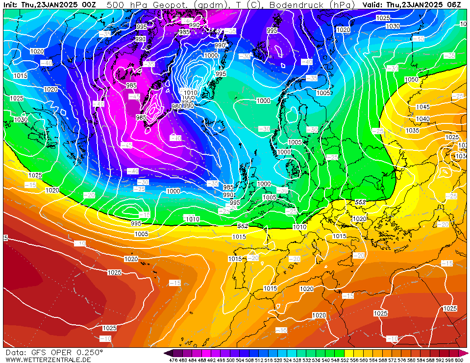
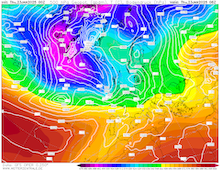
500 hPa geopotential and sea surface pressure
over Europe,
23.01 06 UTC
Source: wetterzentrale
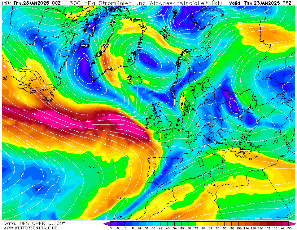
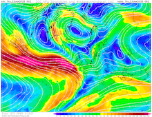
| 300 hPa wind over Europe,
23.01 06 UTC
Source: wetterzentrale
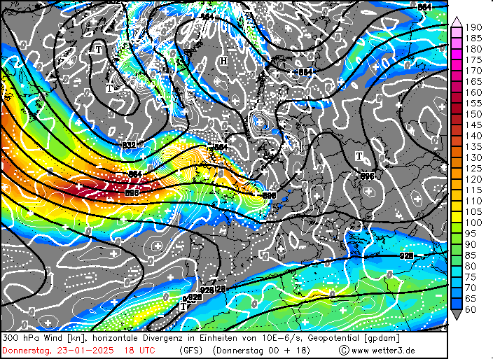
| 300 hPa wind and divergence over Europe,
23.01 18 UTC
Source: wetter3
| Peak wind gusts over the British Isles,
24.01 12 UTC
Source: wxcharts
|
Wind storm
British Isles
Issued: Thursday, January 23, 2025, 08:00 UTC
A rapidly deepening extratropical cyclone is quickly approaching the British Isles. On Friday, January 24, 2025, hurricane-force winds must be expected across the British Isles. South of the cyclone center, widespread wind gusts of more than 120 kph are forecasted. In coastal areas and mountainous terrain, wind gusts of more than 150 kph are possible.
23.01.2025
In the past weeks, the weather pattern across Europe has been dominated by large ridges. A large outbreak of Arctic air masses brought very cold air masses across the North American Continent and the Northern Atlantic (related warning). This induced an active westerly current across the North Atlantic with a remarkably strong jet streak spanning from Newfoundland towards Western Europe with peak wind speeds of more than 350 km according to numerical weather models.
The main low-pressure system of the trough is located between Greenland and Iceland. South of this low-pressure system, a secondary cyclogenesis is currently occurring. During the day, today, January 23, 2025, it is expected that this secondary low-pressure system will move across the jet axis over the North Atlantic. Throughout this process, it is expected that the low-pressure system named Éowyn will rapidly intensify. The rapid intensification is fed by upper-level divergence located in the left exit region of the jet streak near the British Isles. At 06 UTC, numerical weather models estimate the central pressure of storm Éowyn to have already fallen below 985 hPa. Within a 24 h period, rapid intensification is expected (central pressure drops by more than 24 hPa/24 h). By 06 UTC on Friday, the central pressure of the storm may drop below 940 hPa. This indicates a potential deepening rate of nearly 2 hPa/h.
Due to the severe pressure gradient around the storm Éowyn, a dangerous windstorm is forecasted to impact the British Isles on Friday. Hurricane-force wind gusts will impact much of Ireland. Along the coasts of Ireland, wind gusts much above 150 kph are likely. By midday, the center of the wind field will quickly over Britain. Current forecasts indicate that the highest wind gusts are located over the central part of the island. Widespread wind gusts of more than 120 kph must be expected. At higher elevations and in coastal areas, wind gusts of more than 150 kph are possible.
The forecasted track of storm Éowyn relative to the jet axis indicates that the low may develop into a Shapiro-Keyser cyclone. In this case, there is an increased risk of extreme wind gusts south of the cyclone center at the head of the bent-back warm front. In this area, a sting jet may develop during the peak intensity of the cyclone. If reaching the surface, these sting jets can bring the most extreme wind gusts to confined areas.
By Friday evening, storm Éowyn will quickly move northeastwards over the Norwegian Sea. To a lesser degree, high winds may impact the mountainous terrain along the Norwegian Coast on Saturday, January 25, 2025.
Thursday, January 23, 2025, 23:00 UTC
KG
Thursday, January 23, 2025, 08:00 UTC
KG
|