Tuesday, January 21, 2025, 08:00 UTC
|
|
|
|
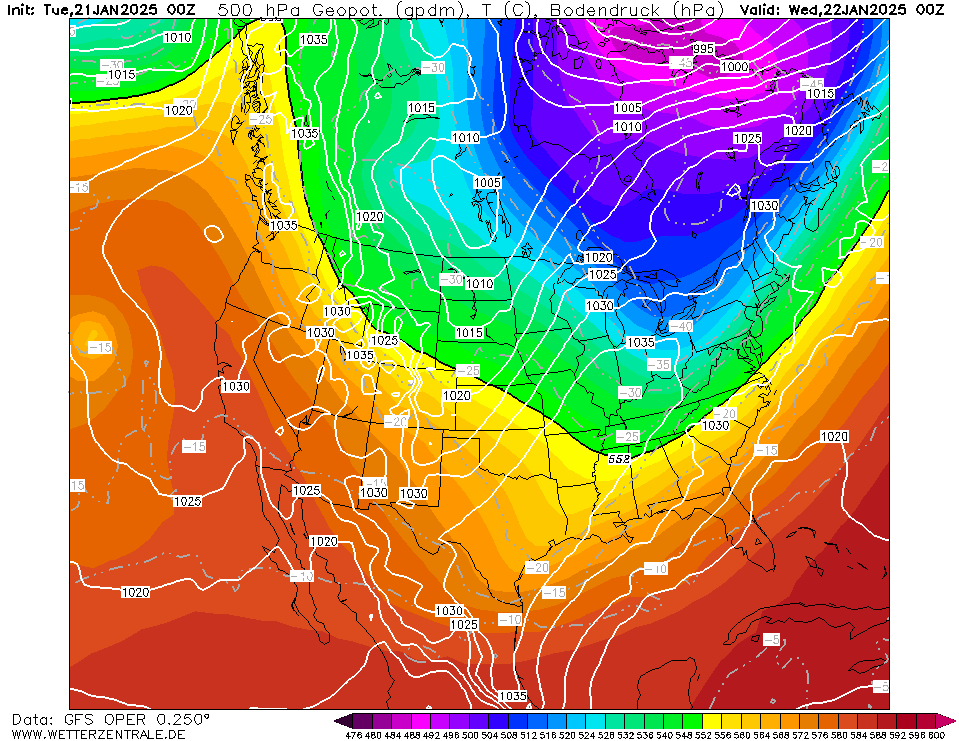
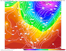
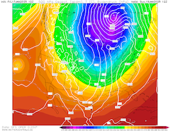
500 hPa geopotential and sea surface pressure
over North America,
22.01 00 UTC
Source: wetterzentrale
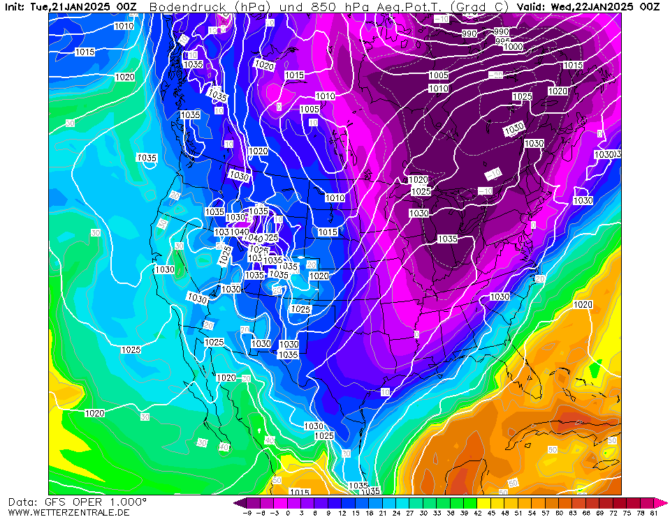
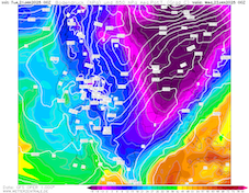
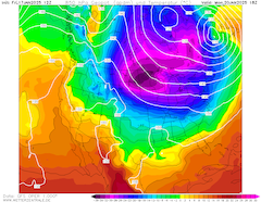
| 850 hPa pseudo-potential temperature and
sea surface pressure over North America,
22.01 00 UTC
Source: wetterzentrale
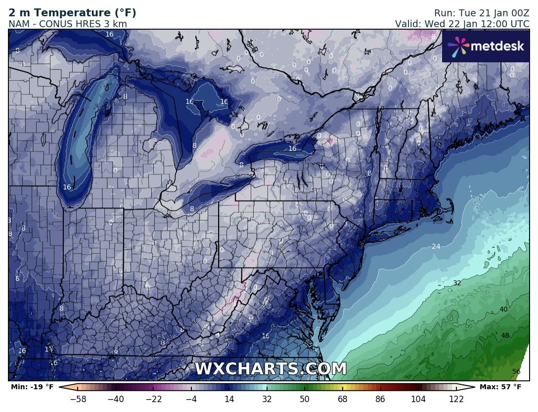
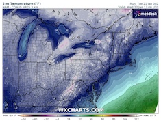
| 2 m temperature over the Northerneastern US,
22.01 12 UTC
Source: wxcharts
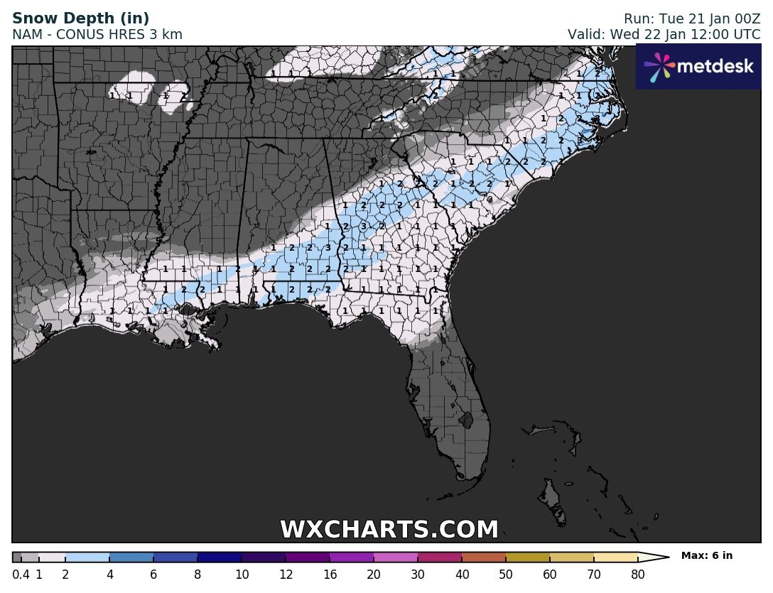
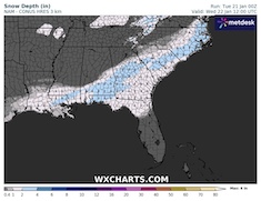
| Snow depth over the Southeastern US,
22.01 12 UTC
Source: wxcharts
|
Cold snap, heavy snow
US, Canada, US Gulf Coast
Issued: Tuesday, January 21, 2025, 08:00 UTC
A strong cold snap is continuing to impact much of the US east of the Rocky Mountains. Shifting to the northeast, temperatures as low as -30 °C are expected in the northern parts of the US. Along the Gulf Coast, a rare snowstorm is expected to bring significant fresh snow accumulations. In the Florida Panhandle, fresh snow accumulations of up to 5 cm may occur.
21.01.2025
On the backside of an elongated trough over the eastern half of North America, Arctic air masses are penetrating far southwards across the US east of the Rocky Mountains. Over the Northern Plains, the 850 hPa temperature is as low as -30 °C. Across the Northern Plains and adjacent Ontario, extreme cold has been observed. Temperatures dropped to -41 °C at Kabetogama, MN on January 20, 2025. With high wind speeds, the wind chill dropped to below -50 °C in the Northern Plains.
With the trough shifting eastwards, the Arctic air mass is also moving eastwards across the US. In the coming days, severe cold must be expected in the New England states. Temperatures below -25 °C may occur in the Northern Appalachian. Further west, temperatures are expected to rise. Dangerously cold nights may still occur in the high-alpine terrain of the Rocky Mountains in Colorado and Wyoming.
Along the Gulf Coast, a major snowstorm is forecasted to bring significant fresh snow accumulations as the Arctic air masses penetrate southwards. Near the Gulf Coast, a sharp air mass boundary with the moist, tropical air mass will form. As a result, heavy precipitation will occur. In a stretch from Houston, TX over the Florida Panhandle to Virginia Beach, VA, significant fresh snow accumulations may occur on Tuesday, January 21, 2025. In the aforementioned areas, fresh snow accumulations of more than 5 cm are possible. Over the Floridian Peninsula, accumulating snow as far south as Gainesville, FL may occur. South of the snowline in Florida, significant icing may occur. In the Florida Panhandle, significant frost may occur both on Wednesday, January 22, 2025, and on Thursday, January 23, 2025, with temperatures potentially falling below -5 °C.
Friday, January 17, 2025, 18:30 UTC
|
|
|
|
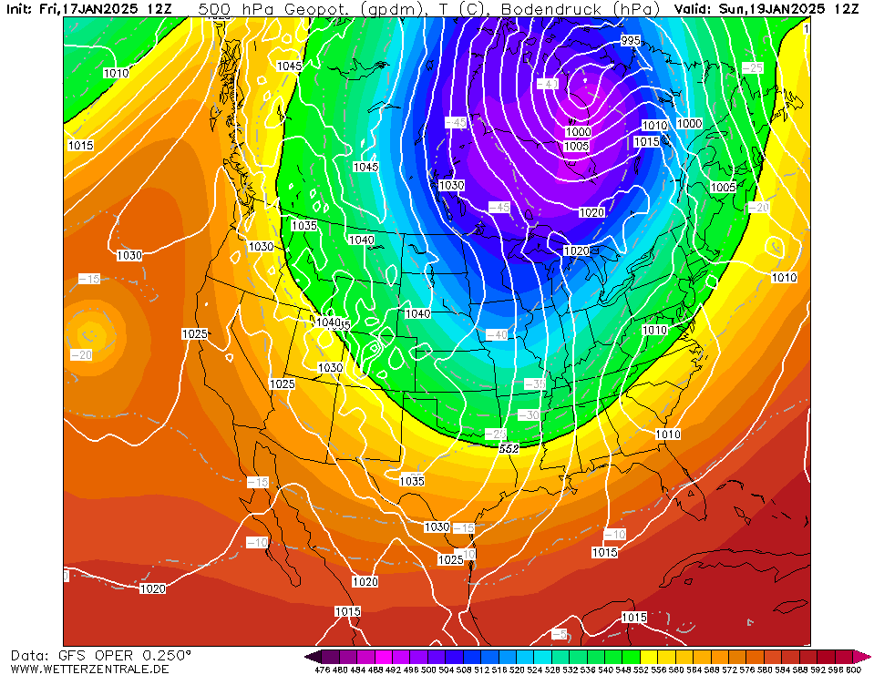
500 hPa geopotential and sea surface pressure
over North America,
19.01 12 UTC
Source: wetterzentrale
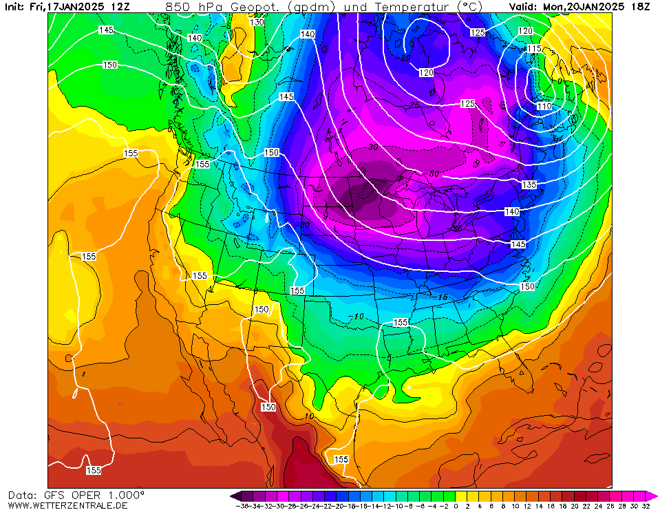
| 850 hPa temperature and geopotential
over North America,
20.01 18 UTC
Source: wetterzentrale
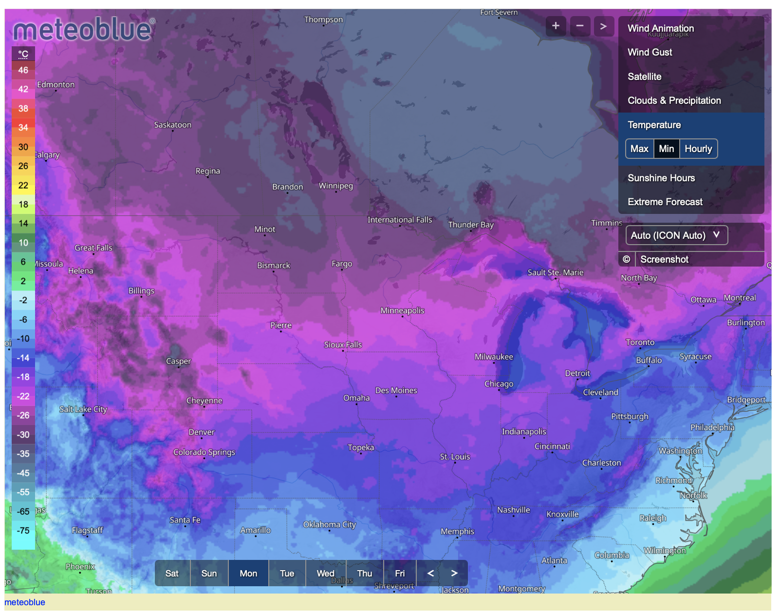
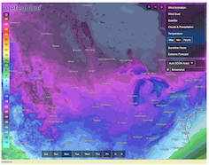
| 2 m minimum temperature over the Northern US,
20.01
Source: Meteoblue
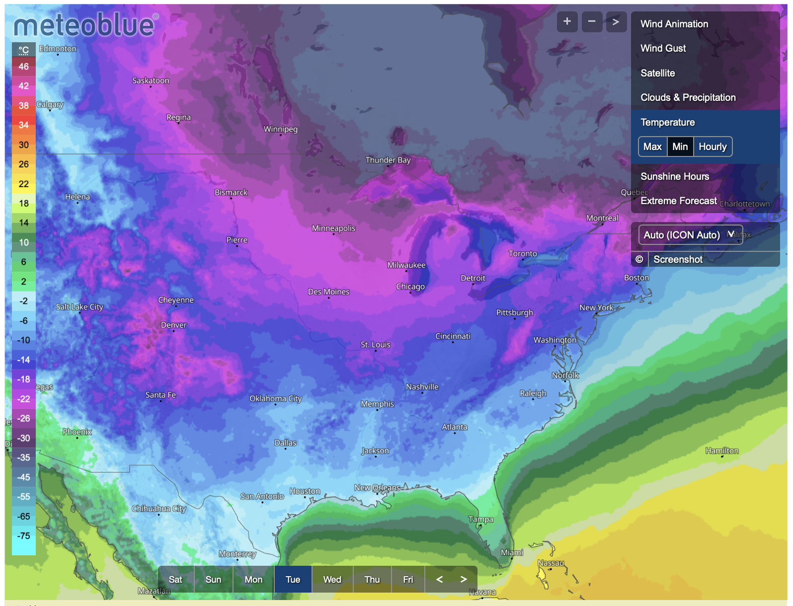
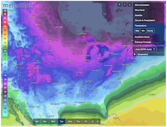
| 2 m minimum temperature over the Eastern US,
21.01
Source: Meteoblue
|
Cold snap
US, Canada
Issued: Friday, January 17, 2025, 18:30 UTC
A significant cold snap is forecasted to impact large parts of the US east of the Rocky Mountains. The Arctic air mass will bring extreme cold with temperatures dropping to below -30 °C for a significant portion of the US. High wind speeds are expected to induce dangerous wind chills to the Northern Plains with wind chill temperatures below -45 °C.
17.01.2025
The hemispheric development of the polar vortex shows a division of the polar vortex over the Arctic. The eastern part of the polar vortex is expected to shift over the Northern Ural. The western part is forecasted to shift over Canada. East of the Rocky Mountains, it is expected that a trough over Canada will plunge far southwards. On the backside of the trough, a large swell of Arctic air masses will be advected southwards. Over the Northern Plains, the 850 hPa temperatures are anticipated to drop below -30 °C by Sunday, January 19, 2025. Along the US-Canadian border in North Dakota and Minnesota, 850 hPa temperatures below -35 °C may occur.
Starting on Saturday, January 18, 2025, a significant cold is expected to impact much of the US east of the Rocky Mountains. Temperatures of less than -20 °C are forecasted to impact the Northern Plains by Sunday. In the nights from Sunday, to Monday, January 20, 2025, and from Monday to Tuesday, January 21, 2025, extremely cold conditions are expected to impact the Northern Plains with temperatures below -30 °C. Day-time highs, around -25 °C are likely to occur on Monday. In the Northern Rocky Mountains, temperatures may drop below -35 °C. In Ontario, temperatures as low as -40 °C are possible. The extreme cold will be exacerbated by high winds gusting to around 50 kph. The resultant wind chill is forecasted to drop below -45 °C in parts of the Northern Plains.
On Tuesday, the coldest air mass will quickly shift eastwards over the Great Lakes Area. Temperatures below -20 °C may impact Chicago. As ice coverage over most lakes is still limited, significant lake effect snow may occur in the areas in the lee of the Great Lakes. A significant portion of the Great Lakes can freeze over during the forecasted cold snap. The ECMWF ice coverage forecast shows the highest ice coverage potential over the southernmost Lake Erie.
Freezing temperatures will spread all the way southwards to the Gulf of Mexico. With the cold front, minor fresh snow accumulations may occur in Southern Texas, potentially impacting metropolitan areas such as San Antonio, Houston, or Corpus Christi. On Wednesday, January 23, 2025, freezing temperatures are likely to impact the Florida Panhandle. In Alabama and Mississippi, temperatures as low as -15 °C may occur.
On Tuesday, the cold snap will have shifted to the Eastern US. In the New England states temperatures below -25 °C are possible. In the Appalachia, temperatures below -20 °C may spread as far southwards as West Virginia. Dangerous cold conditions will also impact the mountain communities that were devastated by Hurricane HELENE in September of last year. Due to the forecasted extremely cold temperatures, the inauguration of President-elect Trump will be shifted indoors as temperatures as low as -15 °C may impact the DC metro on Monday. By Thursday, January 23, 2025, the blob of Arctic air masses will have moved over the Northern Atlantic Ocean. Much milder air masses will reach much of the US.
Tuesday, January 21, 2025, 08:00 UTC
KG
Friday, January 17, 2025, 18:30 UTC
KG
|