Wednesday, October 09, 2024, 08:30 UTC
|

|
|

|
Track and intensity forecast
for Hurricane MILTON,
07.10 14 UTC
Source: NHC NOAA
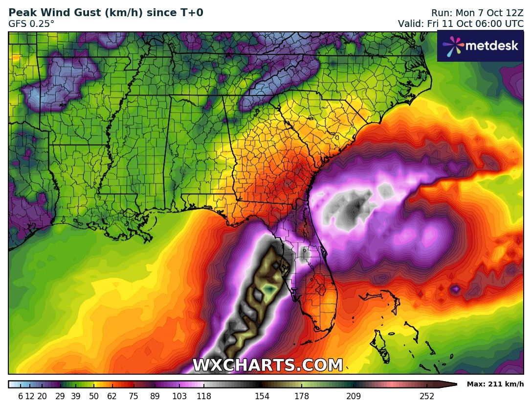
| Maximum wind gusts over the Southeastern US,
until 11.10 06 UTC
Source: wxcharts
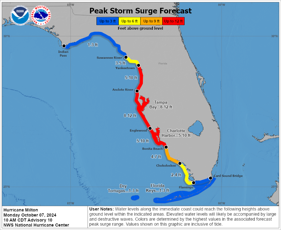
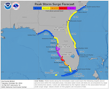
| Peak storm surge along the Floridian Coast
related to Hurricane MILTON
07.10 14 UTC
Source: NHC NOAA
| Accumulated precipitation
over the Southeastern US
until 11.10 06 UTC
Source: wxcharts
|
Tropical cyclone
Florida
Issued: Wedneday, October 09, 2024, 08:30 UTC
Hurricane MILTON is a dangerous category 5 hurricane with a central pressure of 914 hPa and sustained winds of 260 kph. The hurricane is expected to make landfall along the Floridian Gulf Coast near Tampa, FL early on October 10, 2024. The system will bring violent winds with wind gusts of 200 kph and a devastating storm surge of up to 5 m.
09.10.2024
After its extremely rapid intensification to a category 5 hurricane, Hurricane MILTON underwent an eyewall replacement cycle yesterday, October 08, 2024. Before the onset of the eyewall replacement cycle, Hurricane MILTON reached extreme strength. At 00 UTC on October 08, 2024, the central pressure of Hurricane MILTON dropped to 897 hPa with sustained winds of 285 kph. During the eyewall replacement cycle, an outer eyewall builds around the inner eyewall. The outer eyewall deprives the inner eyewall of moisture, which leads to the collapse of the inner eyewall. In this process of re-organization, a tropical cyclone typically weakens. This also holds for Hurricane MILTON as the central pressure of the hurricane increased by 32 hPa and the sustained winds decreased by 55 kph.
In the afternoon hours of October 08, 2024, the eye of the hurricane cleared out, signaling that the hurricane was once again strengthening. By 00 UTC, the central pressure of the hurricane dropped to 902 hPa again with sustained winds of 270 kph. The eye of the hurricane shrank again during this process. During the previous intensification period, the eye of the hurricane was confined to just 6 km.
Currently, Hurricane MILTON retains category 5 strength, as favorable and unfavorable conditions surround the system. The central pressure is at 914 hPa with sustained winds of 260 kph. The hurricane is located above very warm waters with sea surface temperatures of more than 30 °C. Concurrently, dry air masses are located in the vicinity of the hurricane with an increasing upper-level shear. It is expected that the forward motion of the hurricane will increase as it starts to interact with an upper-level trough.
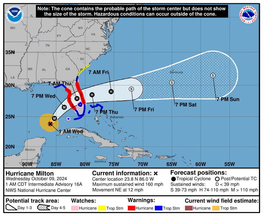
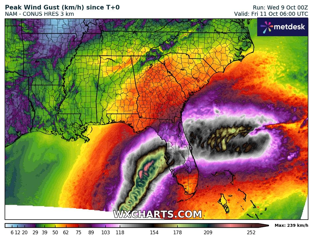
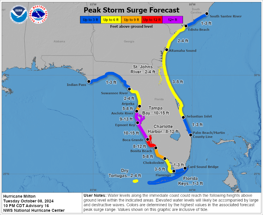
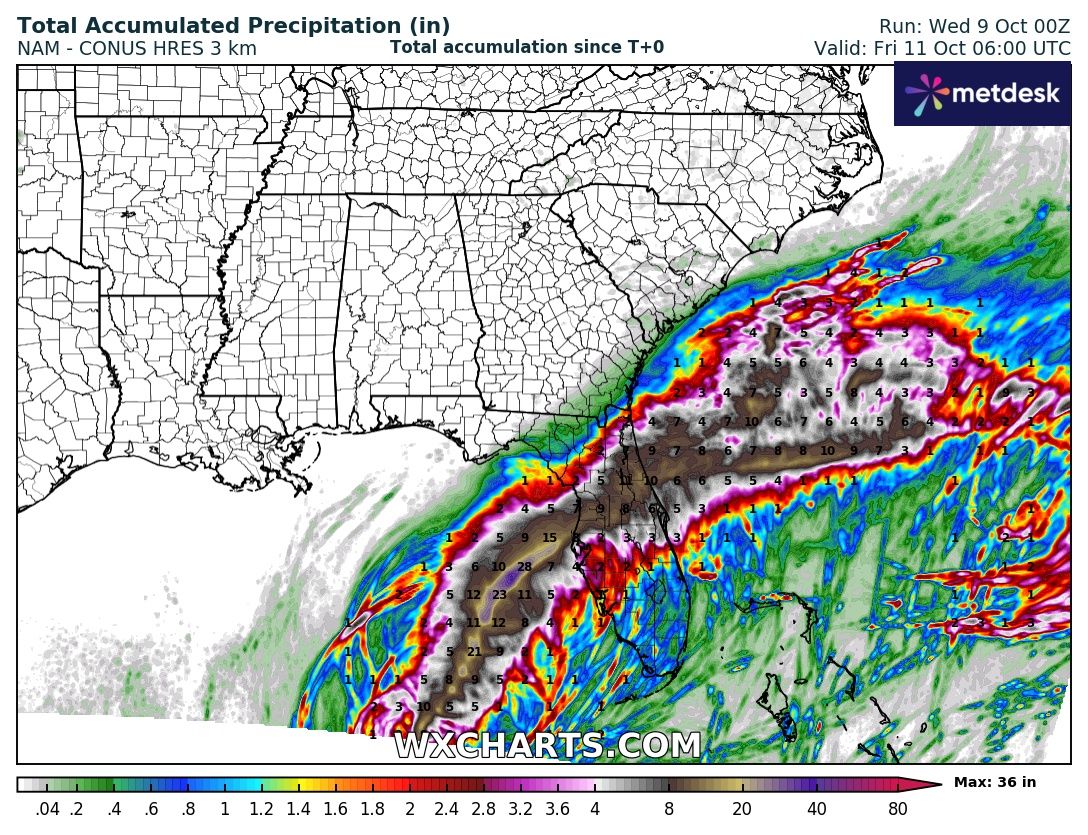
In the coming 24 h before landfall, the model consensus is that Hurricane MILTON will move northeastwards towards the Floridian Peninsula. The wind field of the cyclone is forecasted to expand significantly as a decrease in intensity is expected. Upon landfall, tropical storm force will likely impact nearly the entire Floridian Peninsula from Jacksonville in the north and Miami in the south. Landfall is expected between Cape Coral and Tampa. The last 24 h have seen a shift of the track of Hurricane MILTON to the south. However, a landfall in the Tampa Bay Area remains very much possible. Upon landfall, violent winds will impact Florida with wind gusts of 200 kph. To the north of the cyclone center, torrential rainfalls must be expected. Within a few hours, precipitation totals of more than 250 mm are possible. From Tampa Bay to Cape Coral, a devastating storm surge must be expected. South of the cyclone center, onshore winds may produce a storm surge as high as 5 m.
Along the Atlantic Coast of Florida, the onshore winds of Hurricane MILTON will also form a significant storm surge as the hurricane moves across the Floridian Peninsula. The eye of the hurricane may still be intact as the hurricane moves over the Atlantic. Over the Subtropical Atlantic, the tropical cyclone will decay slowly.
Interests along the Floridian Gulf Coast should in no case at all underestimate the strength of Hurricane MILTON. Devastating impacts are likely to be observed along the Floridian Gulf Coast only seen in the worst of tropical cyclones. Long-lasting impacts of Hurricane MILTON must be expected along the Floridian Gulf Coast between Cape Coral and the Tampa Bay Metropolitan Area.
Monday, October 07, 2024, 17:30 UTC
|

|
|

|
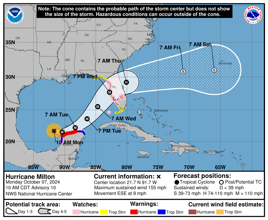
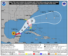
Track and intensity forecast
for Hurricane MILTON,
09.10 06 UTC
Source: NHC NOAA
| Maximum wind gusts over the Southeastern US,
until 11.10 06 UTC
Source: wxcharts
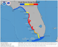
| Peak storm surge along the Floridian Coast
related to Hurricane MILTON
09.10 03 UTC
Source: NHC NOAA
| Accumulated precipitation
over the Southeastern US
until 11.10 06 UTC
Source: wxcharts
|
Tropical cyclone
Florida
Issued: Monday, October 07, 2024, 17:30 UTC
Major hurricane MILTON is forecasted to make landfall along the Floridian Gulf Coast on Thursday, October 10, 2024. The tropical cyclone underwent an extremely rapid intensification, strengthening from a tropical storm into a category 5 hurricane in about 24 h. A catastrophic storm surge is likely to impact the Floridian Gulf Coast.
07.10.2024
Hurricane MILTON is currently located in the northeastern part of the Campeche Bay. The tropical disturbance which would quickly mature into Hurricane MILTON formed over the Campeche Bay as a remnant of Tropical Depression 11E. The tropical disturbance moved from the Pacific into the Gulf of Mexico. Over the warm waters of Campeche Bay, the tropical cyclone found very favorable conditions for the rapid intensification of the system. Yesterday, October 06, 2024, at 15 UTC, tropical storm MILTON had sustained winds of only 100 kph and a central pressure of 991 hPa. With sea surface temperatures (SSTs) of more than 30 °C and weak wind shear, the system could intensify rapidly. Only 25 hours later, the system reached category 5 hurricane strength with sustained winds of 260 kph and a central pressure of 925 hPa.
Currently, Hurricane MILTON is moving east southeastwards nearing the Yucatán Peninsula. Although a direct impact of the hurricane is not expected, the outer bands of Hurricane MILTON will bring high winds, heavy rains, and a major storm surge. It must be noted that currently, in contrast to Hurricane HELENE in late September, Hurricane MILTON is rather small in diameter. The confined inner part of the hurricane is just 160 km across.
After passing by the Yucatán Peninsula later tonight, it is expected that Hurricane MILTON will curve on a more easterly track and traverse the Gulf of Mexico. Current model guidance suggests that the hurricane will be turning northeastwards towards the Floridian Peninsula as it moves ahead of an upper-level trough. Over the eastern half of the Gulf of Mexico, models suggest Hurricane MILTON may slightly weaken on Wednesday, October 09, 2024. This may be caused by an eyewall replacement cycle and the colder SSTs in the wake of Hurricane HELENE. However, this should not be taken for granted. It may very well be possible, that after the eyewall replacement cycle, the hurricane will once again strengthen before its landfall.
At the moment, the track forecast suggests that Hurricane MILTON will make landfall near the Tampa Bay Area. The Tampa Bay Area has not been directly impacted by a major hurricane since 1848. Upon landfall, Hurricane MILTON will bring a catastrophic storm surge, violent winds, and heavy rains. However, fine-track variations will be vital to the strength of the storm surge in Tampa Bay. The 2.5 million large metropolitan area around the bay is at the risk of a 4 m high storm surge. If Hurricane MILTON passes north of the Tampa Bay Area, the onshore winds blowing across the bay may lead to an extreme storm surge in the Bay. The storm surge would be far less severe in Tampa Bay if Hurricane MILTON moves south of the Tampa Bay Area. Then, the winds of the hurricane would blow offshore. In this case, the area around Cape Coral, FL should see a severe storm surge. Regardless of the exact landfalling point of Hurricane MILTON, a storm surge of similar severity as Hurricane IAN in August 2022 must be expected due to the forecasted rapid forward motion of the hurricane.
Furthermore, violent winds with wind gusts of up to 200 kph must be expected along the Floridian Gulf of Coast. Heavy rains with precipitation totals of more than 250 mm may lead to flash and urban flooding. Due to the flat terrain of the Floridian Peninsula, coastal communities along the Atlantic Coast of Florida should also monitor Hurricane MILTON closely. It will likely retain its hurricane strength as it traverses the Floridian Peninsula. A strong storm surge may also develop along the Atlantic Coast of Florida due to Hurricane MILTON.
Wednesday, October 09, 2024, 08:30 UTC
KG
Monday, October 07, 2024, 17:30 UTC
KG
|