Thursday, September 26, 2024, 10:00 UTC
|
|
|
|
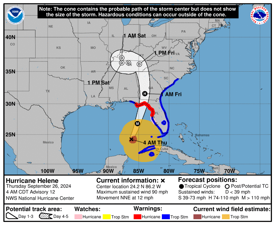
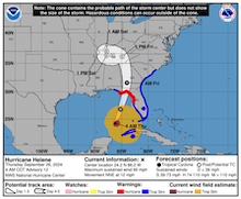
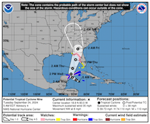
Track and intensity forecast
for Hurricane HELENE,
26.09 08 UTC
Source: NHC NOAA
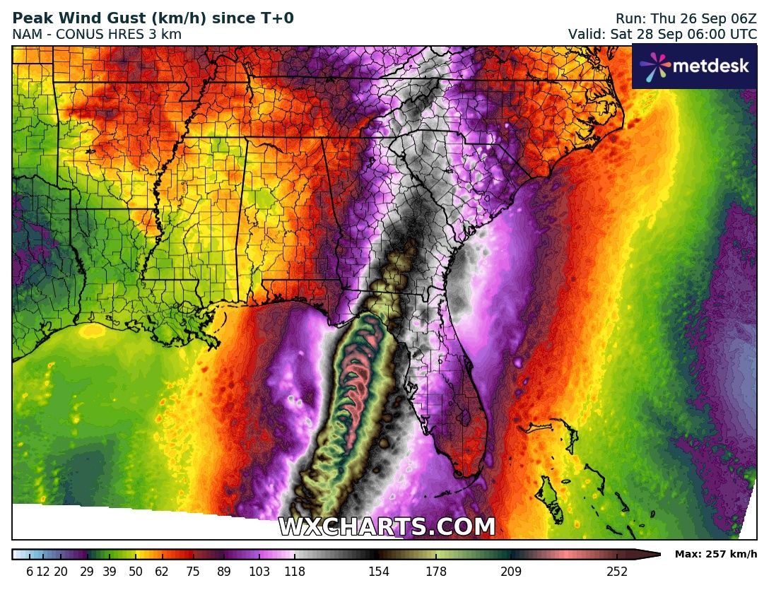
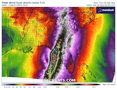
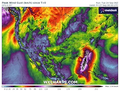
| Maximum wind gusts over the Southeastern US,
until 28.09 06 UTC
Source: wxcharts
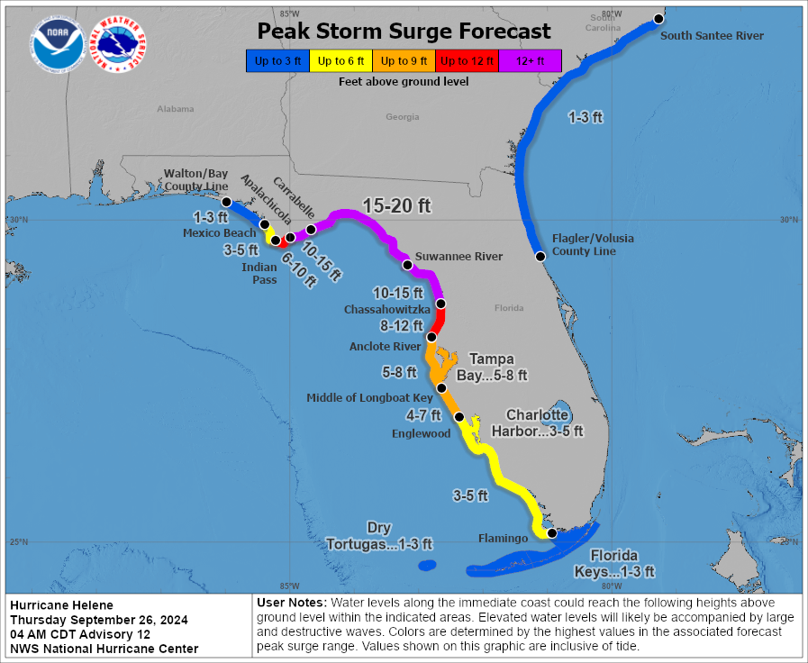
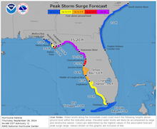
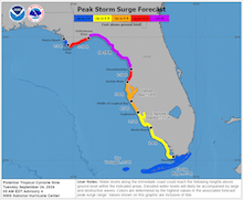
| Peak storm surge along the Floridian Coast
related to Hurricane HELENE
26.09 08 UTC
Source: NHC NOAA
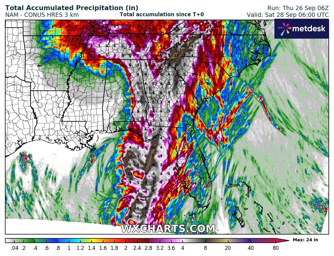
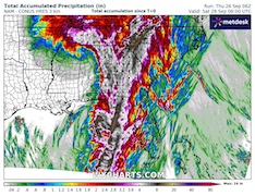
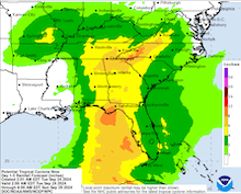
| Accumulated precipitation
over the Southeastern US
until 28.09 06 UTC
Source: wxcharts
|
Tropical cyclone
Southeastern US, Florida
Issued: Thursday, September 26, 2024, 10:00 UTC
Tropical cyclone HELENE has intensified into a hurricane after passing the Yucatán Channel. In a favorable environment of low mid-level shear and upper-level divergence, Hurricane HELENE is expected to intensify rapidly over the warm waters of the Gulf of Mexico. Landfall is expected early on September 27, 2024, as a major hurricane in the Florida Big Bend region.
26.09.2024
Tropical cyclone HELENE reached hurricane strength on September 25, 2024, over the Yucatán Channel. From the Yucatán Channel, the system is currently moving northeastwards across the Gulf of Mexico. For tropical-cyclone standards, the system has a forward movement across the Gulf of Mexico as it interacts with an upper-level trough over the Mississippi Valley. Over the warm waters of the Gulf of Mexico with SSTs of more than 30 °C, the system will find favorable conditions for the intensification of the tropical cyclone. Besides the warm waters, the environment around the tropical cyclone will have only weak mid-level shear and upper-level divergence.
Today, September 26, 2024, Hurricane HELENE is expected to intensify into a major hurricane and grow significantly in size. Upon landfall early tomorrow morning, September 27, 2024, Hurricane HELENE will have sustained winds of up to 200 kph. Current track guidance expects Hurricane HELENE to make landfall in the Florida Big Bend region. At the moment, it seems likely that Hurricane HELENE will make landfall in the Apalachee Bay where also Hurricane IDALIA made landfall just 13 months prior. HELENE may directly impact Tallahassee, FL. Upon landfall, the hurricane will bring heavy rains and violent winds. Furthermore, a catastrophic storm surge is expected to impact large parts of the Floridian Gulf Coast. Near the center of the hurricane, a storm surge of more than 6 m cannot be excluded.
Due to the rapid movement of the cyclone, hurricane-strength winds will likely stretch far inland as the system moves into Georgia. Even far-inland locations in Central and Northern Georgia may see hurricane-strength winds. Especially in the southern Appalachians, torrential rains must be expected. Precipitation totals of more than 350 mm are expected in the Appalachians in Tennessee. Most of this precipitation will likely fall within a 24 h period. Due to these torrential rains, severe flash and urban flooding must be expected.
After moving further inland, Hurricane HELENE is expected to curve cyclonically around the upper-level trough over the Midwest. As the remnants of Hurricane HELENE interact with the mid-level trough, an extratropical transition of the system may occur as it decays over the Midwest.
Tuesday, September 24, 2024, 10:00 UTC
|
|
|
|
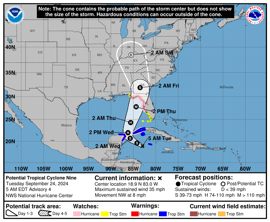
Track and intensity forecast
for Potential Tropical Cyclone Nine,
24.09 09 UTC
Source: NHC NOAA
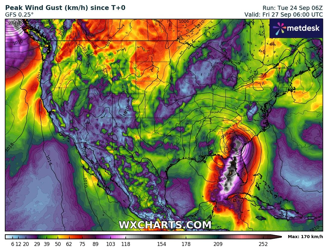
| Maximum wind gusts over the Contiguous US,
until 27.09 06 UTC
Source: wxcharts
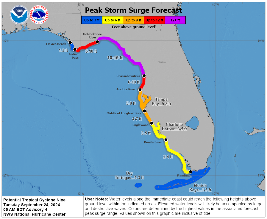
| Peak storm surge along the Floridian Coast
related to Potential Tropical Cyclone Nine
24.09 09 UTC
Source: NHC NOAA
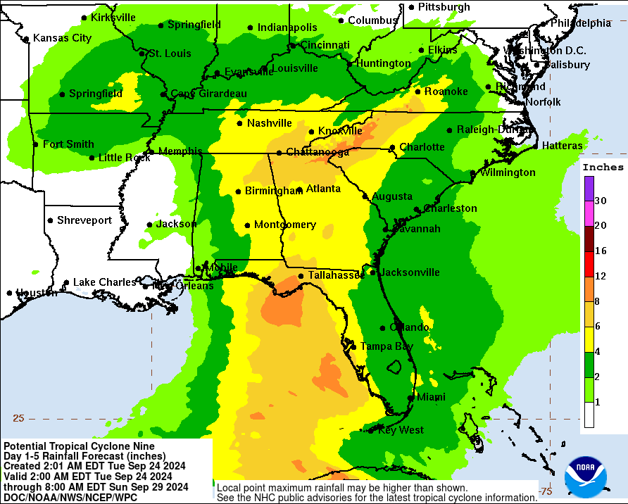
| 5-day accumulated precipitation
over the Southeastern US
until 29.09 12 UTC
Source: NHC NOAA
|
Tropical cyclone
Southeastern US, Florida
Issued: Tuesday, September 24, 2024, 10:00 UTC
Potential Tropical Cyclone Nine is expected to form in the coming hours over the Yucatán Channel between the Yucatán Peninsula and Western Cuba. On its northward trajectory, the tropical cyclone is expected to intensify into a hurricane before making landfall along the Gulf Coast of Florida on Friday, September 27, 2024.
24.09.2024
A tropical disturbance is located south of the Yucatán Channel in the Caribbean Sea. At the moment, the broad area of organizing tropical convection is moving northwestwards with peak wind gusts of 55 kph. Later today, September 24, 2024, the tropical disturbance Potential Tropical Cyclone Nine is expected to intensify into tropical cyclone HELENE. After the passage of the Yucatán Channel between the Yucatán Peninsula and Western Cuba, the tropical cyclone is expected to intensify into a hurricane over the warm waters of the Gulf of Mexico.
Over the Gulf of Mexico, the trajectory of the system is expected to turn in a northeasterly direction. With sea surface temperatures (SSTs) of more than 30 °C in the Gulf of Mexico, very favorable conditions for the intensification of the system are forecasted. Therefore, Potential Tropical Cyclone Nine is expected to intensify into a hurricane while traversing the Gulf of Mexico. Before nearing the Gulf Coast of Florida, Potential Tropical Cyclone Nine may reach major hurricane strength.
Currently, forecasts consensus is that Potential Tropical Cyclone Nine will likely make landfall along the Floridian Gulf Coast between Tampa Bay and Panama City on September 27, 2024. Potential Tropical Cyclone Nine will have likely intensified into a major hurricane before landfall. In the past two years, two major hurricanes have made landfall along the Floridian Gulf Coast. Hurricane IAN made landfall near Fort Myers as a category 5 hurricane in September 2022. Last year in August, Hurricane IDALIA made landfall as a category 3 hurricane in Apalachee Bay.
Upon landfall, the tropical cyclone will bring violent winds and heavy rains. During the passage of the system, parts of Florida and Georgia could see precipitation totals of up to 200 mm. Due to the shallow coastline of Florida, the main risk of this system will be related to a potentially catastrophic storm surge. With onshore winds, a very large storm surge may develop on the eastern side of the tropical cyclone. Furthermore, it must be noted, that due to the very warm waters of the Gulf of Mexico, a rapid intensification of Potential Tropical Cyclone Nine may occur. First high-resolution regional weather models suggest a much stronger hurricane to form. Though, this is still very uncertain. A more detailed assessment of the strength of the tropical cyclone upon landfall is possible once the system has developed.
Thursday, September 26, 2024, 10:00 UTC
KG
Tuesday, September 24, 2024, 10:00 UTC
KG
|