|
A bomb cyclone off the US East Coast has brought a historic blizzard to the Northeastern Megalopolis stretching along the I-95 corridor. Widespread 24 h fresh snow accumulations of more than 30 cm were observed. The highest fresh snow accumulations were measured in Rhode Island, where the state-wide record for 2-day fresh snow accumulations was shattered with a 2-day fresh snow accumulation of 96 cm.
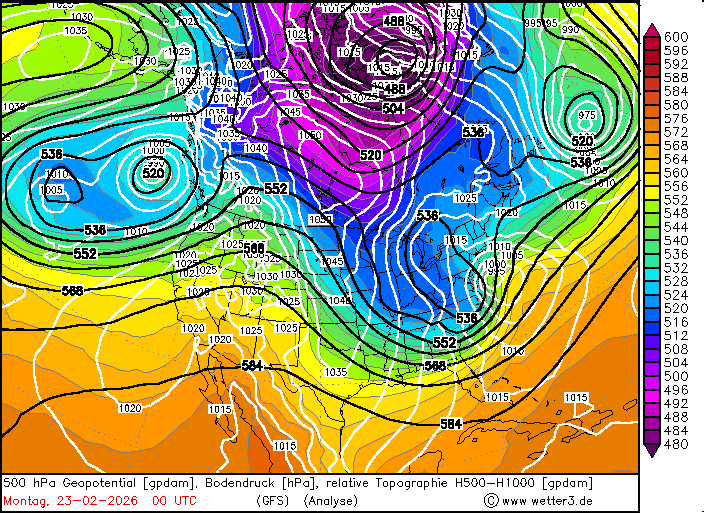
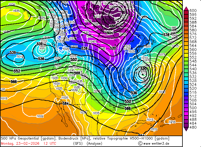
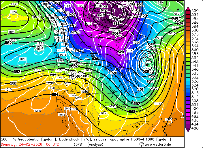
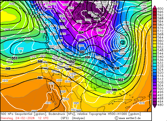
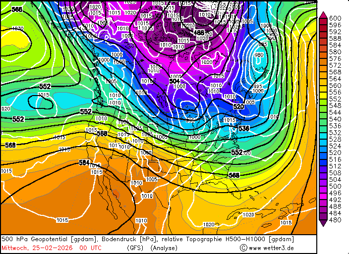
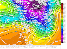
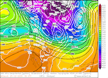
The winter season 2025/26 has been the harshest in years along the US East Coast. A major snowstorm already impacted much of the Northeastern Megalopolis stretching along the I-95 corridor in late January. A large trough system reached the Western US in mid-February. By February 21, 2026, the center of the extensive trough was located over the Great Plains. Ahead of the trough, a small surface low developed over the Southeastern US. This surface low interacted with a shortwave upper-level trough above on February 22, 2026. Moving over the open ocean, the surface low underwent a phase of explosive cyclogenesis and rapidly intensified on February 23, 2026.
|
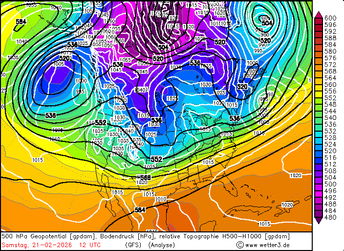
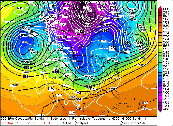
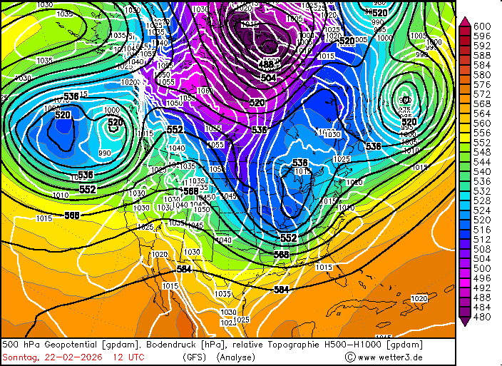
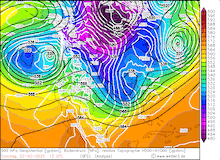
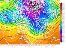
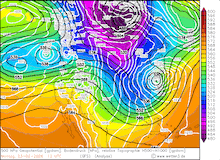
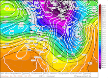
Development of the 500 hPa geopotential, 1000 hPa to 500 hPa thickness, and sea-surface pressure over North America, 21.02.2026 12 UTC - 25.02.2026 00 UTC, source:
Wetter3
|
 |
 |
 |
 |
 |
 |
 |
 |
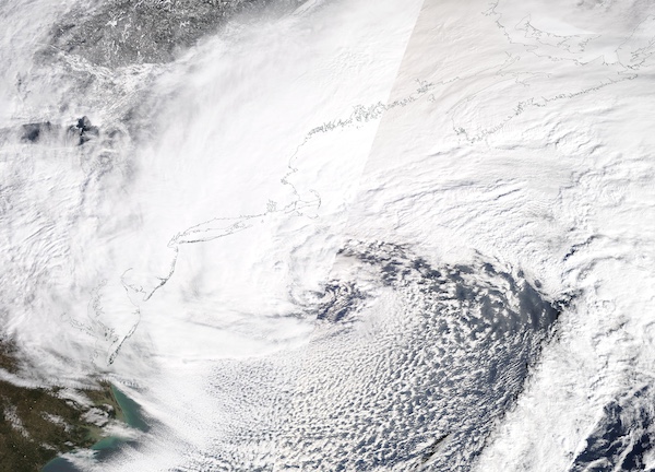
Within a 24 h period, the central pressure of the surface low dropped by more than 24 hPa, fulfilling the threshold for explosive cyclogenesis. By 21 UTC on February 23, 2026, the central pressure of the storm bottomed out at 965 hPa. Over the open ocean near the US East Coast, satellite imagery revealed the powerful structure of the storm. An extensive bent-back warm front wrapped around the cyclone center. Along this extensive warm front, strong snow bands formed, which first started to impact the Mid-Atlantic states, primarily impacting New Jersey and the New York City metropolitan area on February 22, 2026. Hourly fresh snow accumulations of multiple centimeters impacted the I-95 corridor.
|
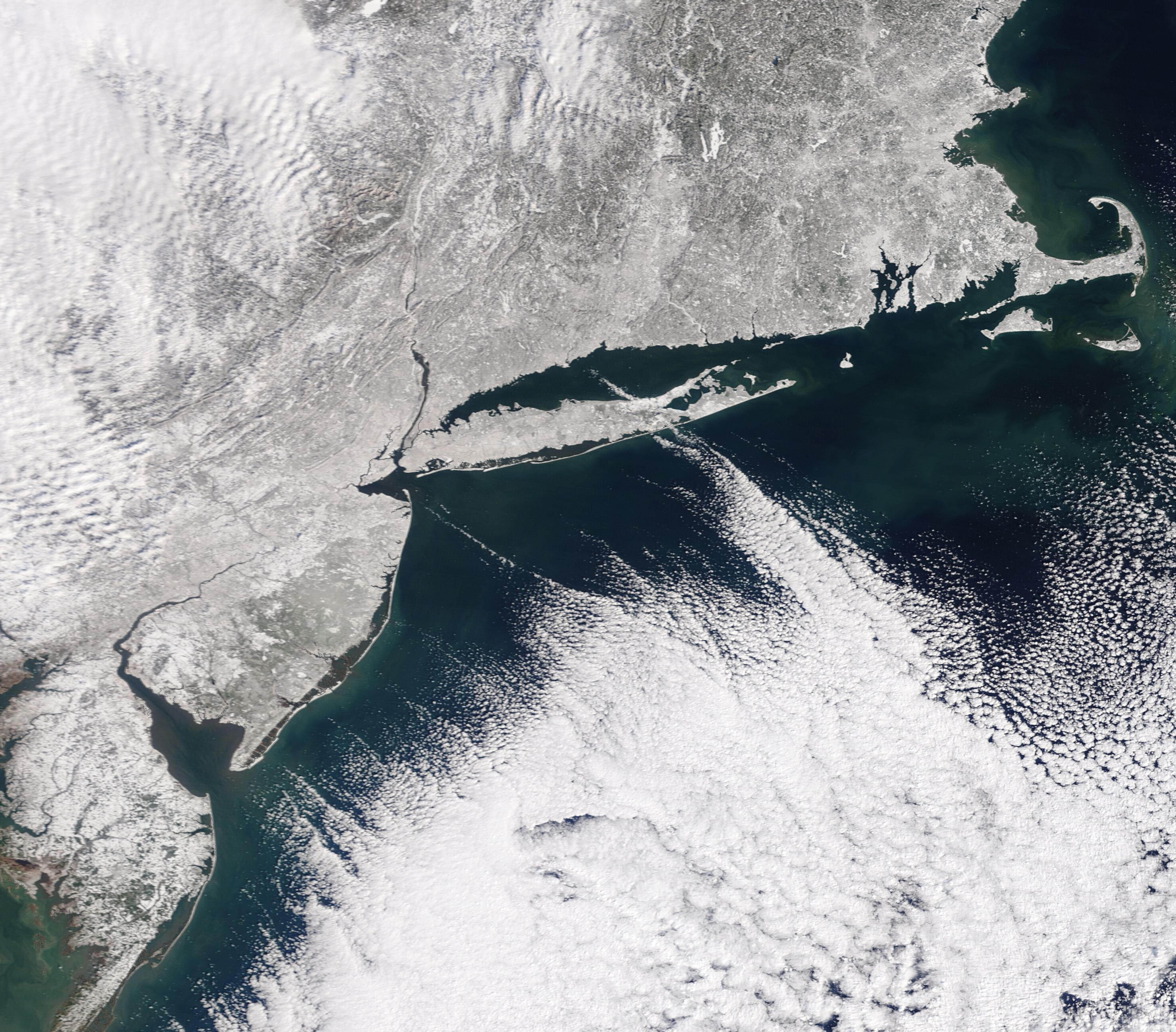
Visible satellite imagery of the bomb cyclone off the US East Coast near peak intensity, 23.02.2026, source:
NASA Worldview
|
 |
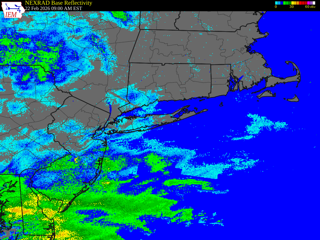
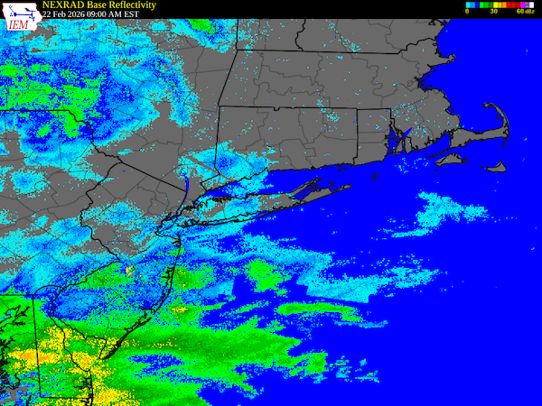
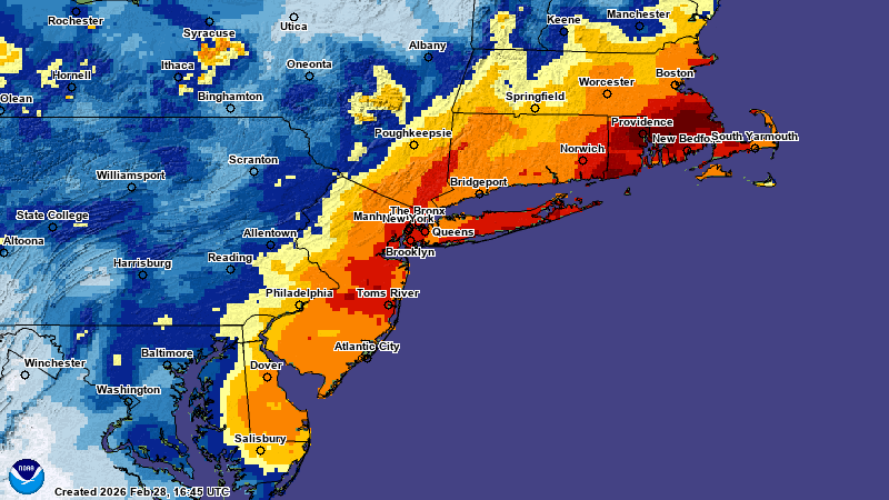
Significant fresh snow accumulations stretched westwards into Western Pennsylvania. However, the largest fresh snow accumulations were heavily focused on the coastal side of the I-95 corridor. Often, fresh snow accumulations surpassed the 30 cm threshold. In the NYC metro, fresh snow accumulations of up to 50 cm were reported from the weather station at Central Park. This ranks the recent snowstorm among the ten most powerful snowstorms to impact NYC since record-keeping began. On February 23, 2026, the heaviest fresh snow bands shifted northeast along with the surface low. In the sector of the storm, where the bent-back warm front wrapped along the western flank of the cyclone center, powerful snow bands started to form, which continuously impacted the Southern New England states of Connecticut, Rhode Island, and Massachusetts. In these snow bands, fresh snow accumulations of more than 5 cm were observed spanning multiple hours. The coastal areas experienced white-out conditions as hurricane-force winds combined with the heavy snow. On Cape Cod, a peak wind gust of 158 kph was observed at Wellfleet, MA.
15-minute radar imagery over the Southern New England states showing continuous heavy snow bands impacting the area
during the passage of the blizzard, 22.02.2026 14 UTC - 25.02.2026 02 UTC, source:
NWS New York
|
 |
Lasting well into February 23, 2026, heavy snow bands continued to impact a narrow strip stretching across Rhode Island to Cape Cod. In this area, widespread fresh snow accumulations of more than 60 cm were observed. In Rhode Island, the largest fresh snow accumulation was measured at the Rhode Island T.F. Green International Airport with a 2-day fresh snow accumulation on February 22 and February 23, 2026, of 96 cm. Both the 24 h and 48 h state-wide records for fresh snow accumulation were surpassed in Rhode Island. Both were held by the infamous Blizzard of 1978. In nearby Massachusetts, fresh snow accumulations peaked at 86 cm, with up to 78 cm in Connecticut. On February 24, 2026, moderate fresh snow accumulations occurred in the Northern New England states, remaining below 30 cm.
|
72 h fresh snow accumulations across the Northeastern US, 21.02.2026 12 UTC - 24.02.2026 12 UTC, source:
NOHRSC NOAA
|
 |
The combination of extreme fresh snow accumulations and hurricane-force winds led to treacherous travelling conditions along the I-95 corridor connecting the Northeastern Megalopolis. Up to 600,000 customers were left without power during the passage of the blizzard. At least 13 fatalities can be attributed to the blizzard along the US East Coast. The extensive snow cover in the Southern New England states may raise flooding concerns during the spring thaw.
Text: KG
February 28, 2026
|