|
An extensive cold period affected large parts of Europe around the turn of the year. In Germany, an unusually cold and snowy winter storm caused major travel disruptions. In the Northern Germany Lowlands, winter storm Elli brought abundant fresh snow accumulations of more than 20 cm. A second low-pressure system named Gunda brought an end to the cold period with locally significant freezing rain accumulations.
Since the Christmas season, an unusually cold and wintry weather pattern has affected large parts of Europe. Uncommon is the onset of this cold weather period around Christmas. Following the turn of the year, cold temperatures persisted across Central Europe. Strong convective showers led to locally extensive snow coverage around the North and Baltic Seas. These were caused by a persistent northerly flow across Central Europe induced by the combination of a strong ridge over the Northern Atlantic and a trough over Scandinavia. At times, the early-January snow coverage in Europe was the largest in years.
|
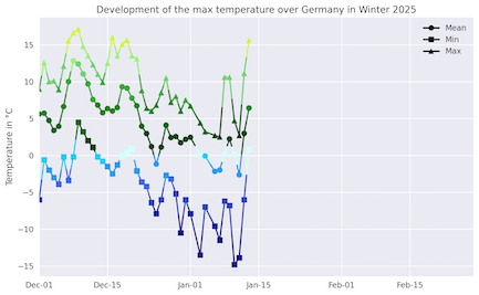
Daily development of maximum (left) and minimum (right) temperature over Germany in winter 2025/26, 01.12.2025 - 13.01.2026, source:
Wettergefahren-Frühwarnung
|
 |
 |
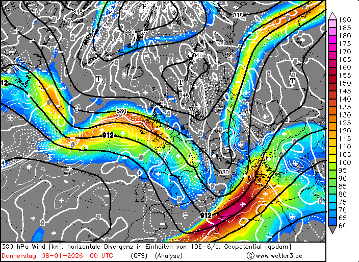
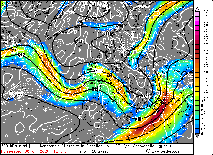
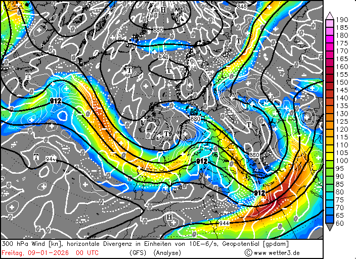
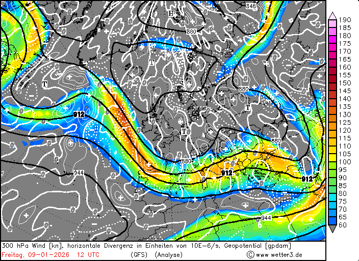
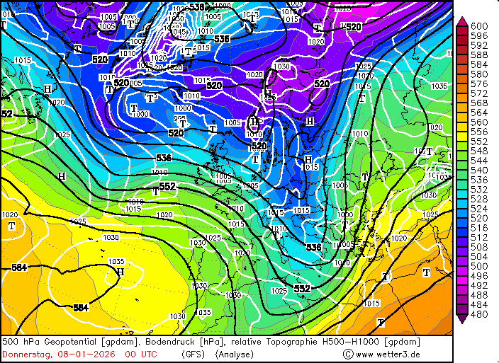
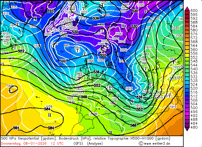
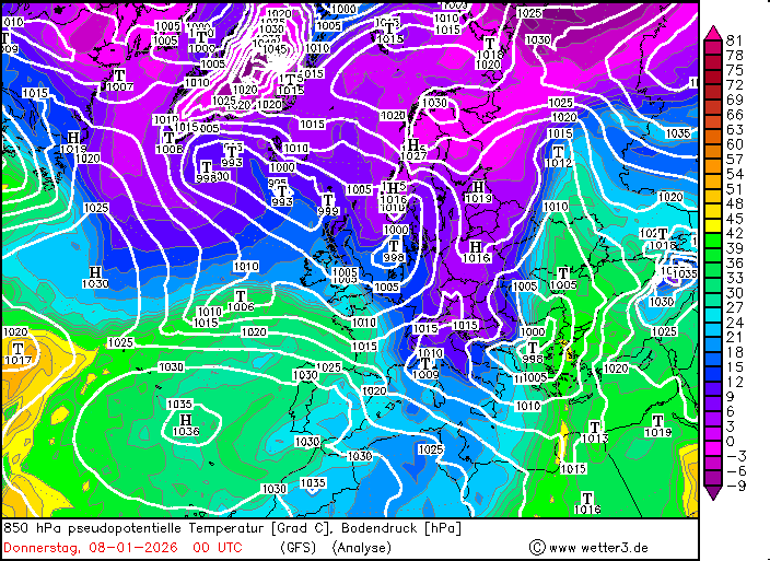
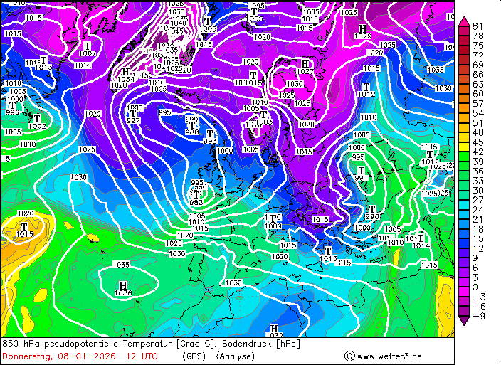
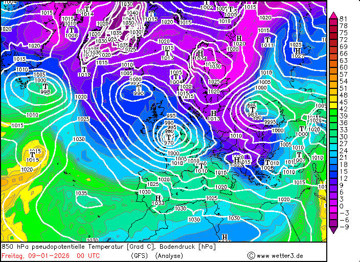
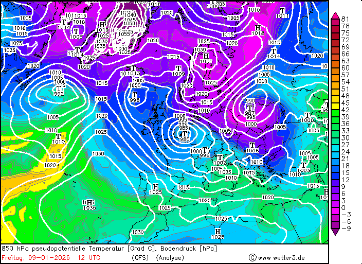
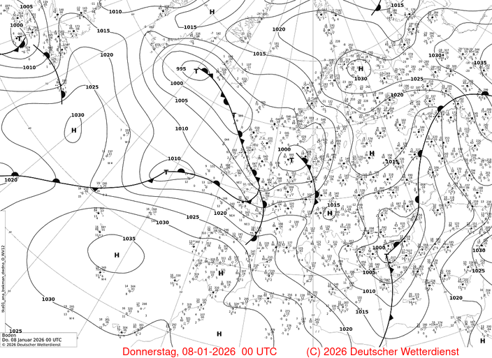
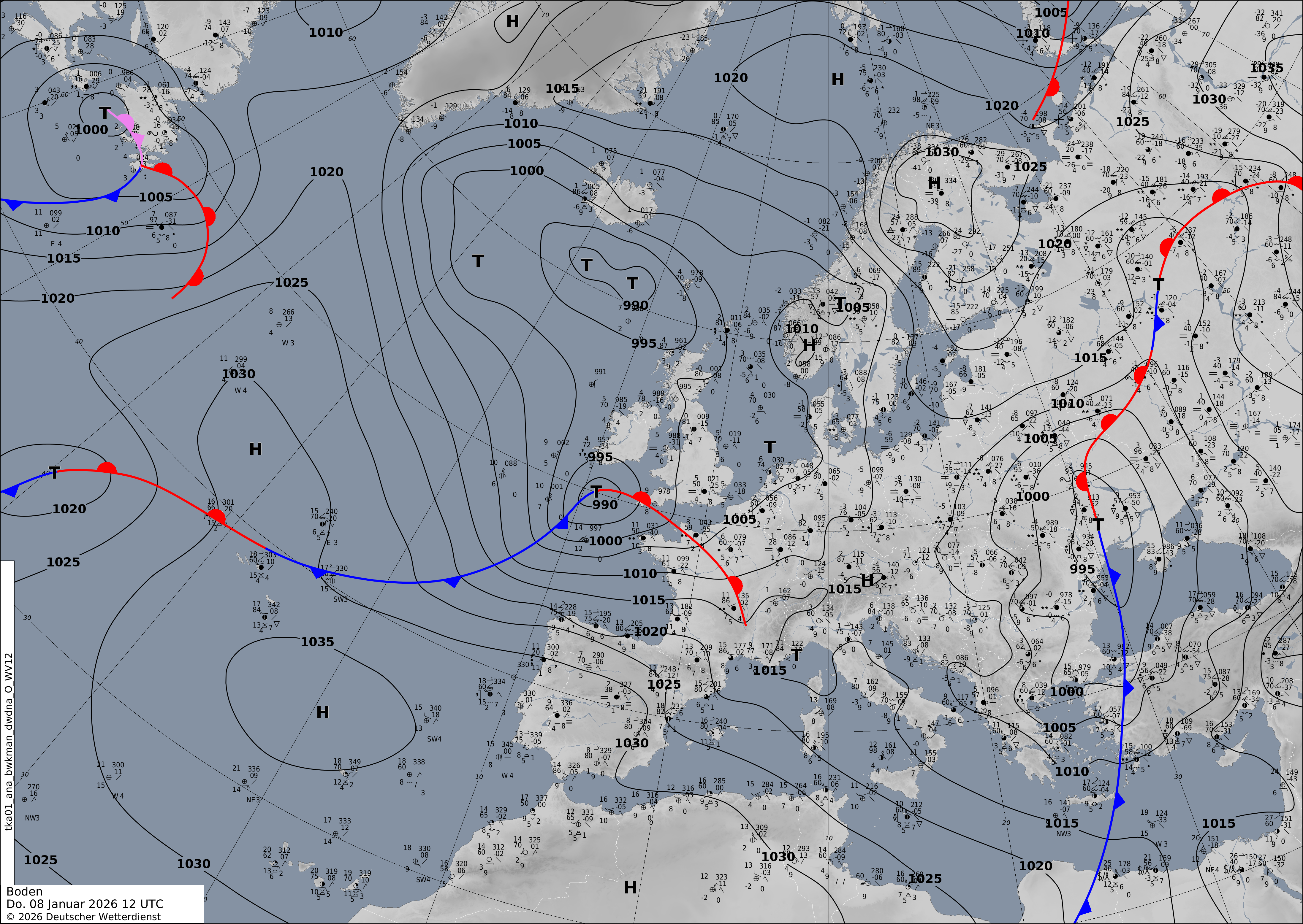
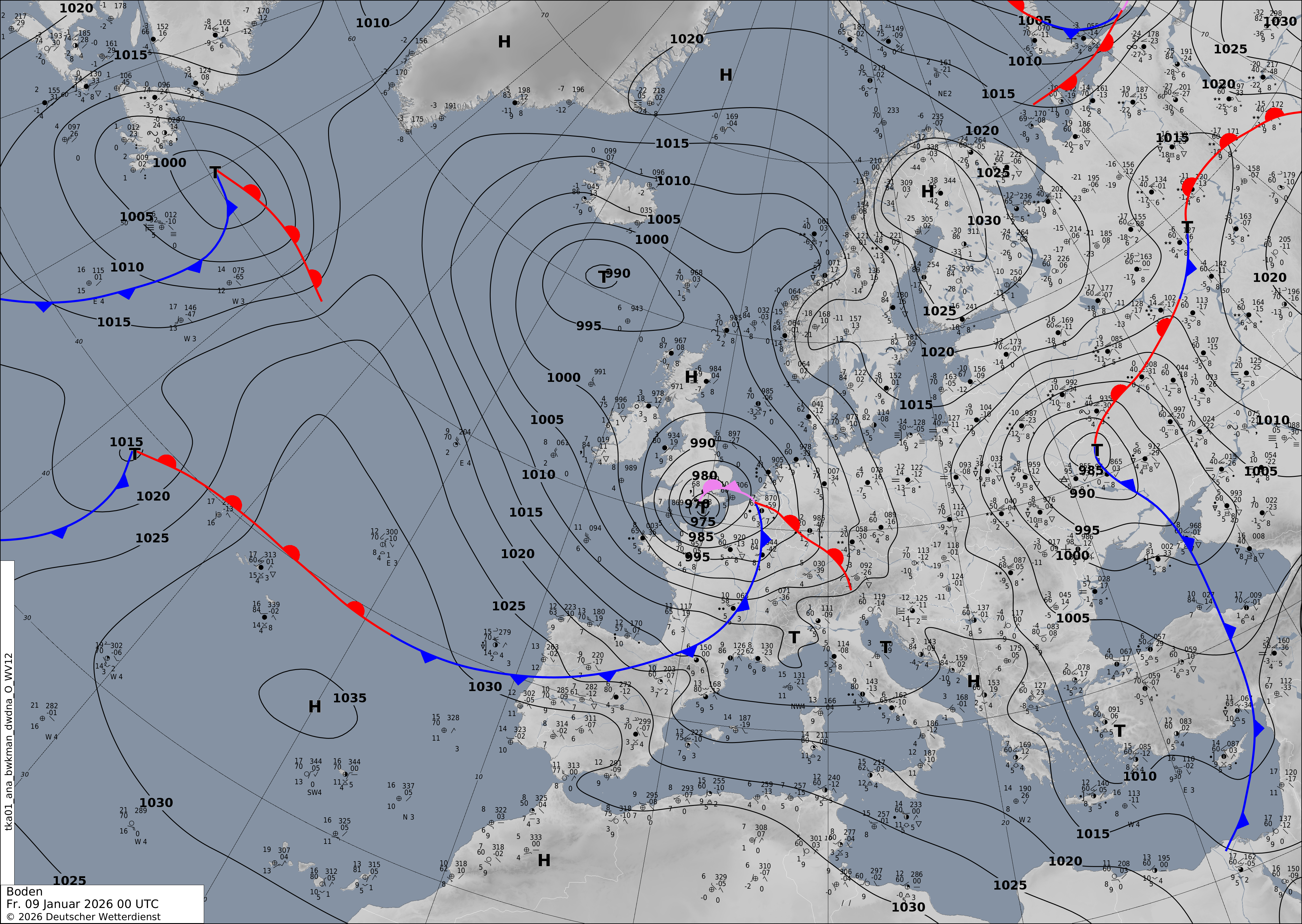
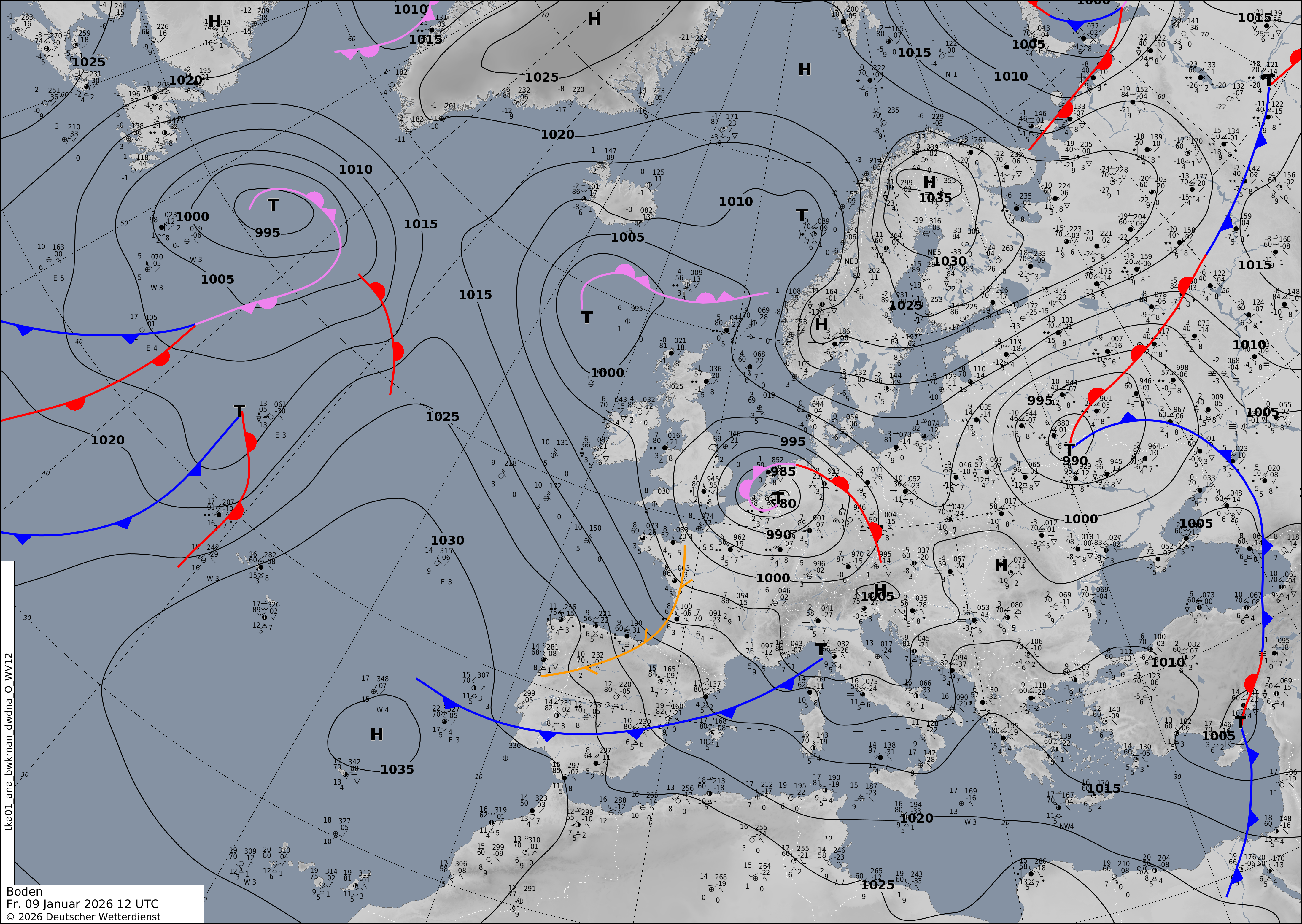
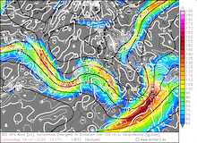
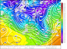
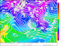
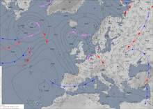
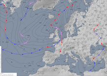
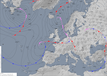
In early January 2026, a large outbreak of Arctic air masses reached the Northern Atlantic near Newfoundland. This Arctic outbreak caused enhanced dynamic activity east of Canada. The subsequent low-pressure system development was powerful enough to pass south of the developed Greenland block. By January 08, 2026, a zonal current with a strong northwesterly tilt matured across the Northern Atlantic. Along said zonal current, a significant meridional temperature gradient developed with warm subtropical air masses to the south and cold polar air masses to the north. Along this air mass boundary, a low-pressure system developed on January 08, 2026, a few hundred kilometers east of Ireland. In the following 24 h, the low-pressure system intensified rapidly. The central pressure of the low dropped from 1006 hPa on January 08, 2026, at 00 UTC to 970 hPa on January 09, 2026, at 00 UTC. This translates to 24 h pressure drop of 36 hPa, well above the threshold for explosive cyclogenesis.
|
Development of the 300 hPa wind and divergence (first row), 500 hPa geopotential, 1000 hPa to 500 hPa thickness, and sea-surface pressure (second row), 850 hPa pseudo-potential temperature and sea-surface pressure (third row), source:
wetter3.de,
and sea-surface pressure and analyzed fronts (fourth row) over Europe, 08.01.2026 00 UTC - 09.01.2026 12 UTC, source:
DWD
|
 |
 |
 |
 |
 |
 |
 |
 |
 |
 |
 |
 |
 |
 |
 |
 |
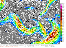
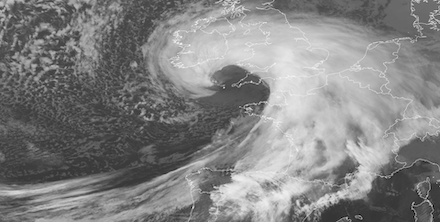
By the afternoon hours on January 08, 2026, the rapidly deepening low named Elli (int. Goretti) approached the southwestern tip of Cornwall. A very sharp pressure gradient along the back flank of the storm caused very high wind speeds both in Cornwall and in Brittany across the English Channel. By 16 UTC, wind gusts in Brittany reached hurricane-force. High wind speeds advanced eastwards with storm Elli, which moved along the English Channel. In the Normandy region, extreme wind gusts started to be observed by 21 UTC. Along the coast, wind gusts reached more than 150 kph. At 23 UTC, the highest wind speed associated with storm Elli was observed at the measuring site Gatteville-le-Phare with a peak wind gust of 213 kph.
|
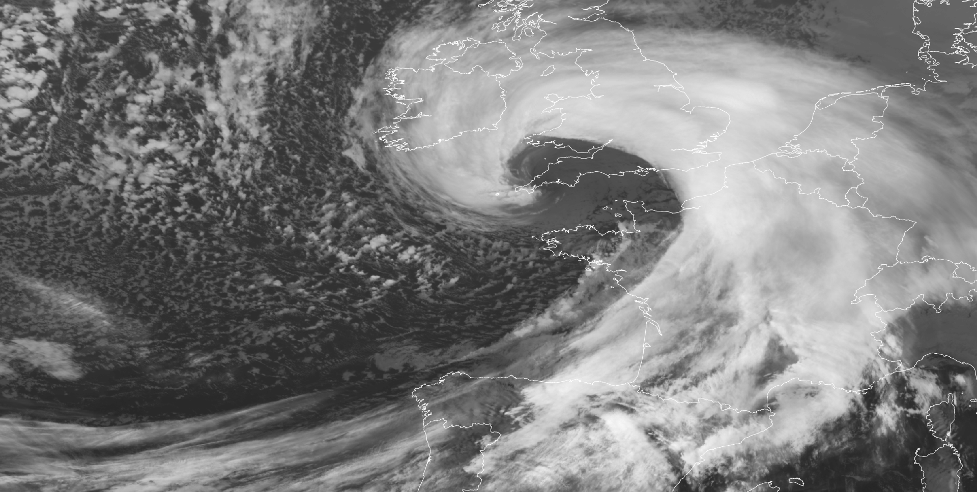
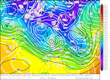
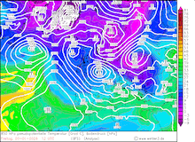
2-hourly infrared satellite imagery of low Elli (int. Goretti) showing the development of a distinct cloud head at the tip of the bent-back warm front. The finger-like structure at the tip of the cloud head hints at the prescence of a sting jet, 08.01.2026 14 UTC - 22 UTC, source:
EUMETSAT View
|
 |
 |
 |
 |
The wind speed measurements along the English Channel indicate that the peak wind field of storm Elli exhibited a high local and temporal confinement in a small area located southwest of the center of the low-pressure system. At the same time, low Elli exhibited a classic comma shape on visible and infrared satellite imagery, which is characteristic of Shapiro-Keyser cyclones. The satellite imagery in the afternoon and evening hours of January 08, 2026, shows that a distinct cloud head starts to mature at the tip of the bend-back warm front in the southwestern quadrant of the cyclone. By 14 UTC, finger-like structures at the tip of the cloud head started to appear. These matured as the cyclone approached Cornwall. By midnight, these finger-like structures started to disappear as the cloud head wrapped further around the cyclone center. The temporal coincidence of these cloud features southwest of the cyclone center of storm Elli and the powerful wind gusts along the English Channel hints that a potential sting jet had near-surface interactions. This might have caused the powerful wind gusts observed in Normandy, as the extreme surface wind gusts related to sting jets are most often highly confined both on a temporal and a local scale.
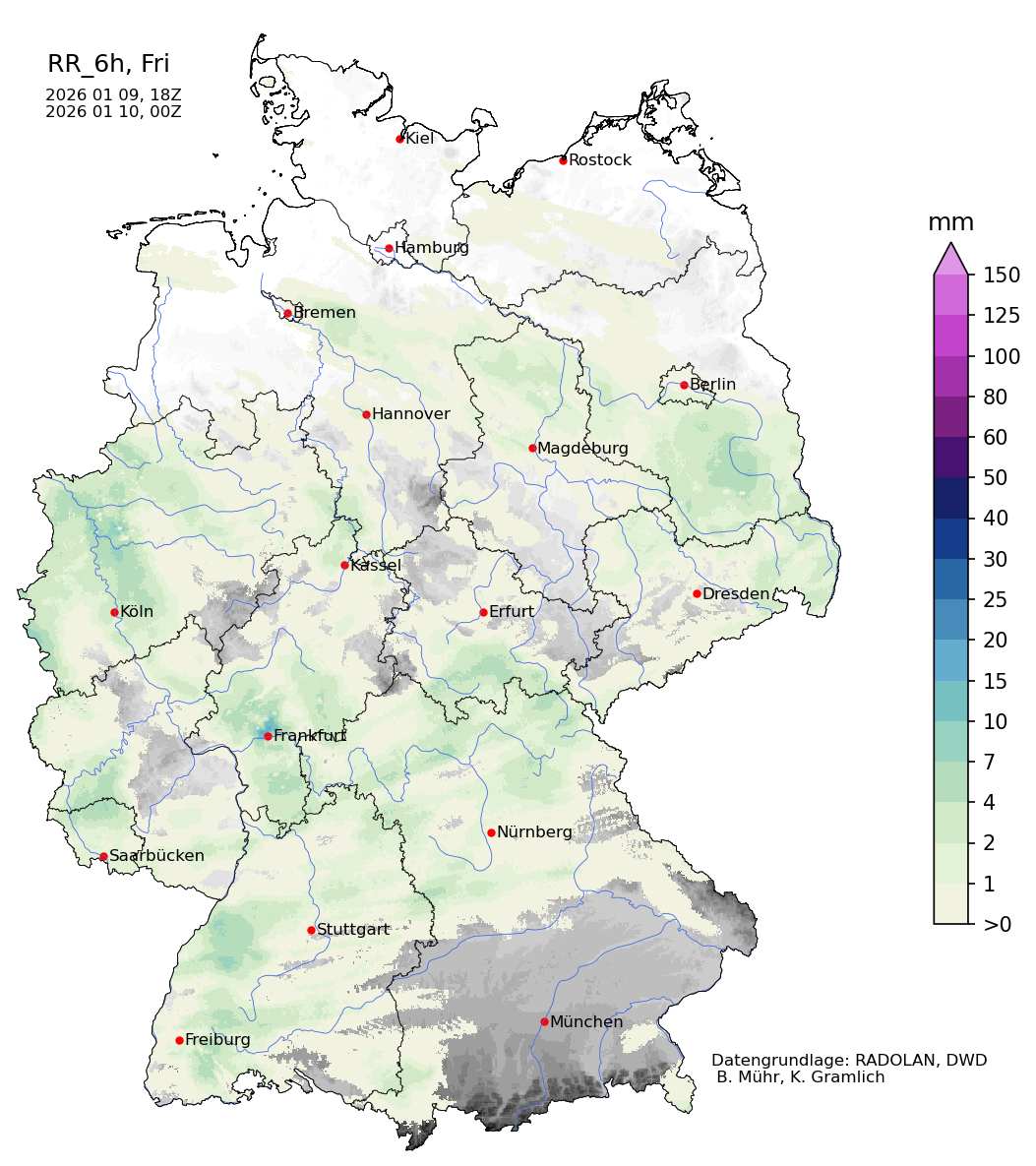
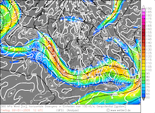
Early on January 09, 2026, low Elli reached the Southern Netherlands. The extensive warm front of low Elli produced persistent snow across the Northern Germany lowlands. On January 09, 2026, the forward motion of storm Elli decreased sharply as the low-pressure system started to interact with a trough over Eastern Europe. Throughout the day, the low-pressure system stalled with its center over the Southern Netherlands. The low subsequently started to fill and moved slowly to the southeast across Germany, where the storm ultimately dissipated.
|
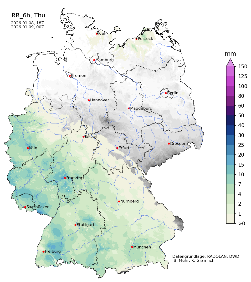
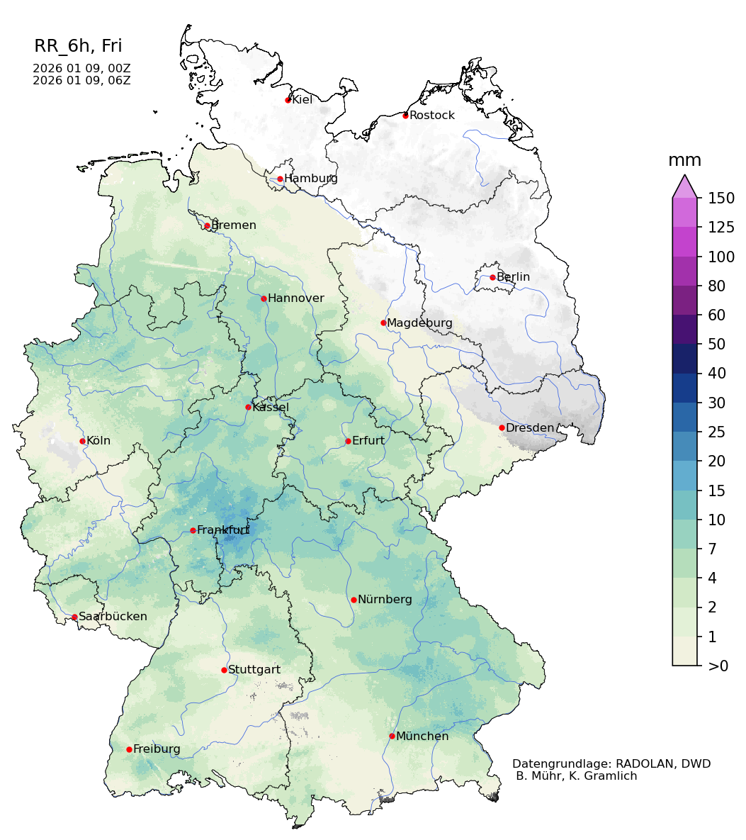
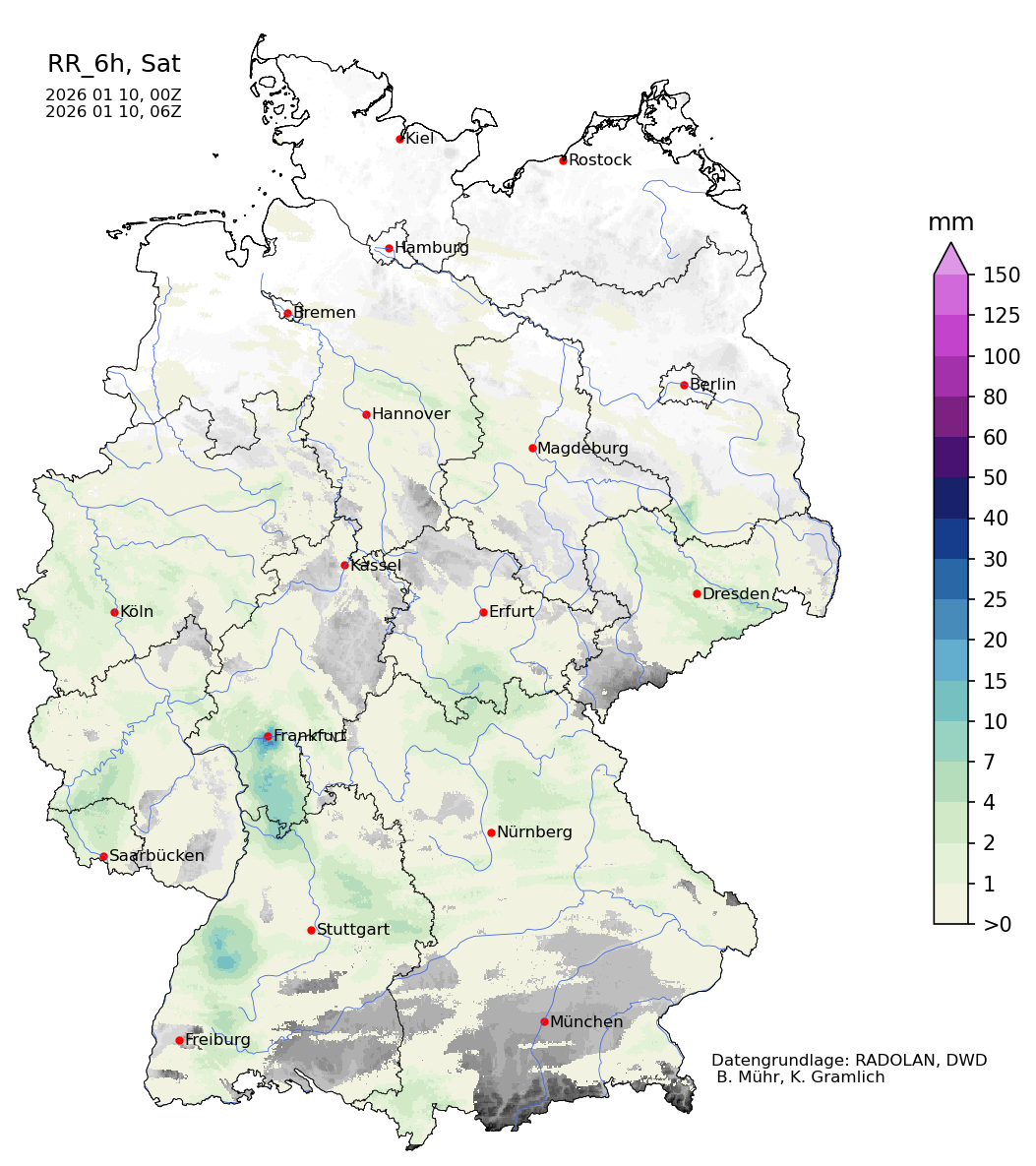
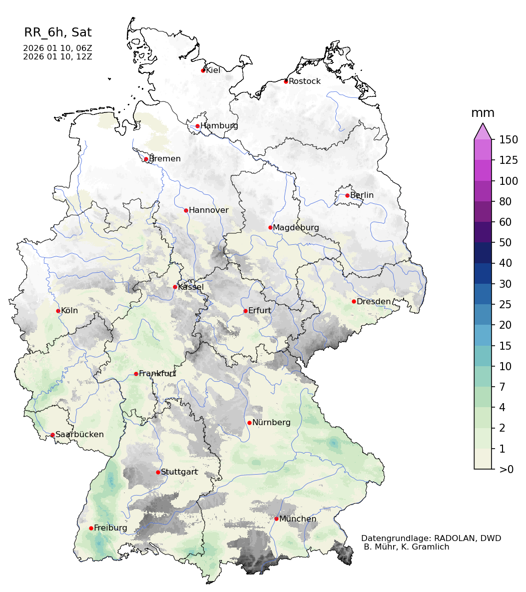
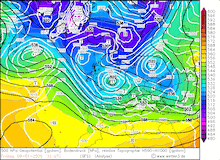
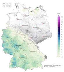
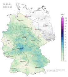
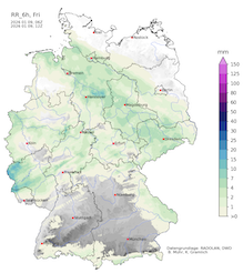
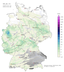
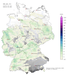
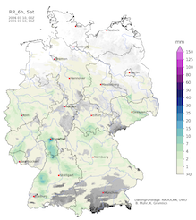
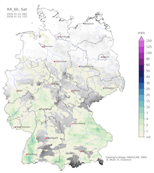
6-hourly radar-indicated precipitation totals over Germany, 08.01.2026 18 UTC - 10.01.2026 18 UTC, source:
Wettergefahren-Frühwarnung
|
 |
 |
 |
 |
 |
 |
 |
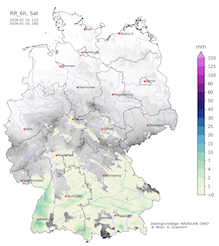 |
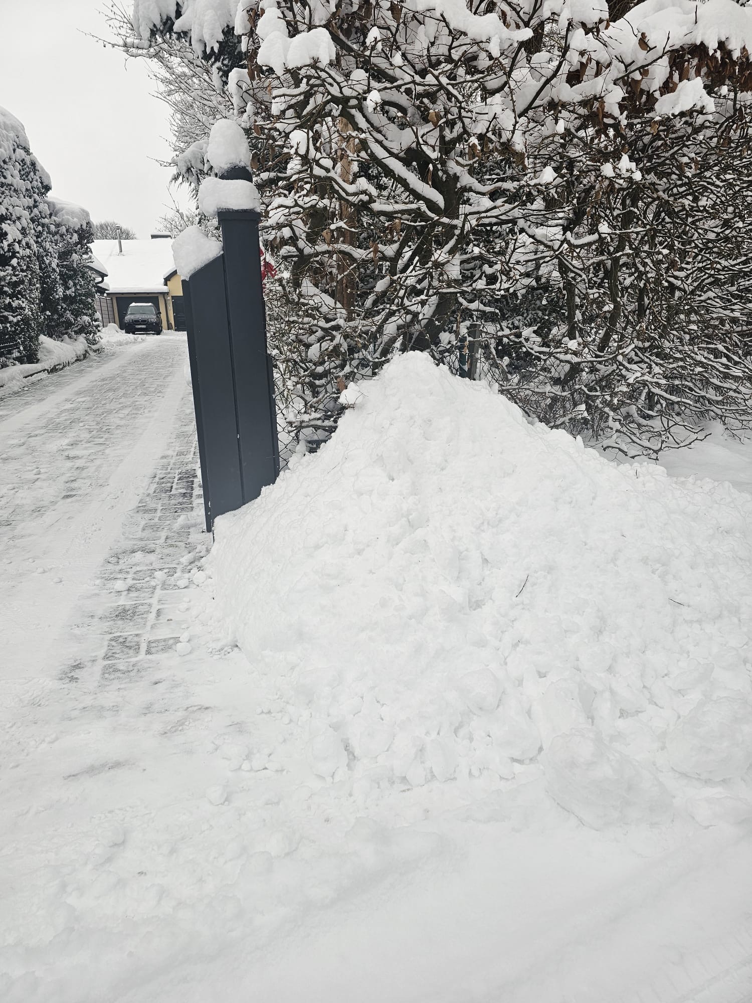
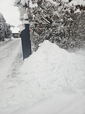
Due to the slow forward motion of low Elli across Central Europe, the weather-active warm front of Elli was situated across Northern Germany for around 24 h. In Western Germany, the warm front was powerful enough that the milder air masses could mix through to the surface, and led to liquid precipitation. Across Northern Germany, the milder air masses could not penetrate through to the surface, and thus, persistent snow was observed. Between Hamburg and Hannover, fresh snow accumulations of up to 20 cm were reported on January 09, 2026. The snow accumulation was accompanied by strong easterly winds with wind gusts of up to 60 kph. The combination of the strong easterly winds and the significant fresh snow accumulations caused locally significant snow drifts. This induced treacherous travelling conditions in large parts of Northern Germany. The German state railway discontinued all service in the affected areas.
|
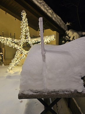
Impressions of the significant snow cover in Hamburg following the passage of winter storm Elli, 09.01.2026, source:
K. Rahloff
|
 |
 |
 |
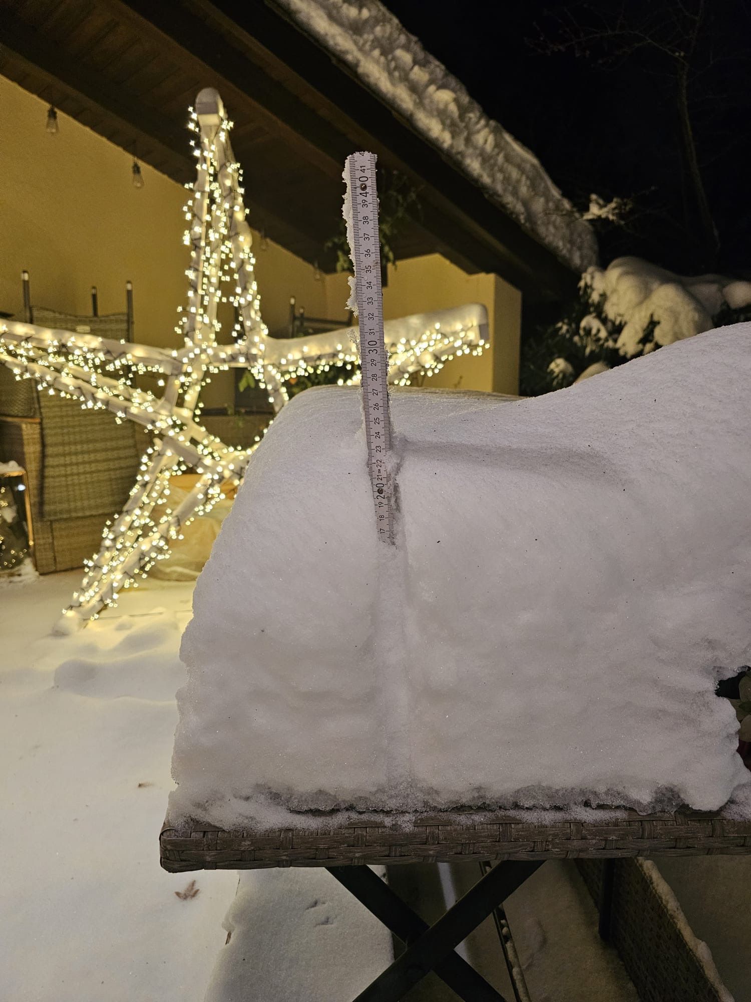
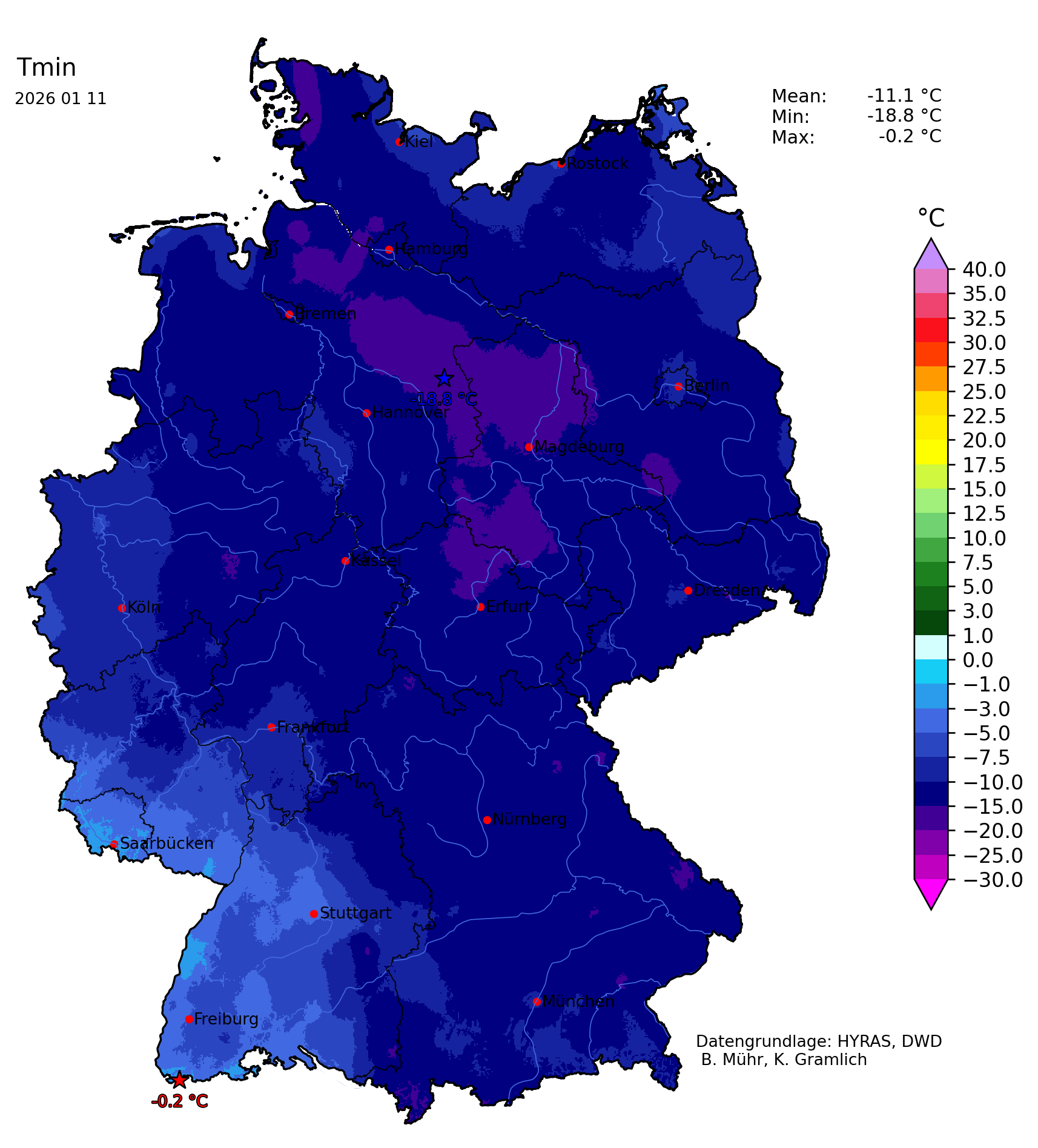
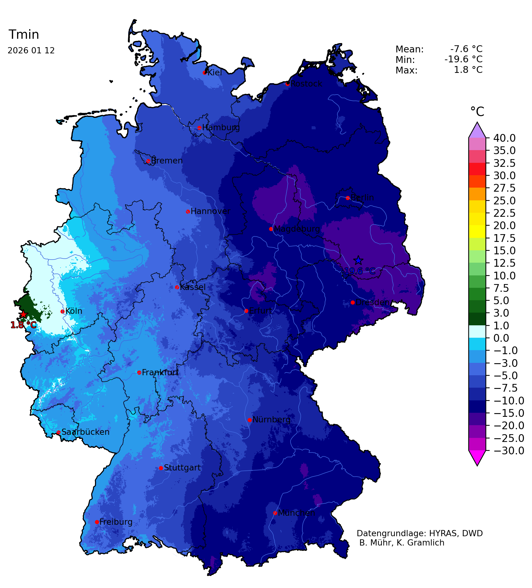
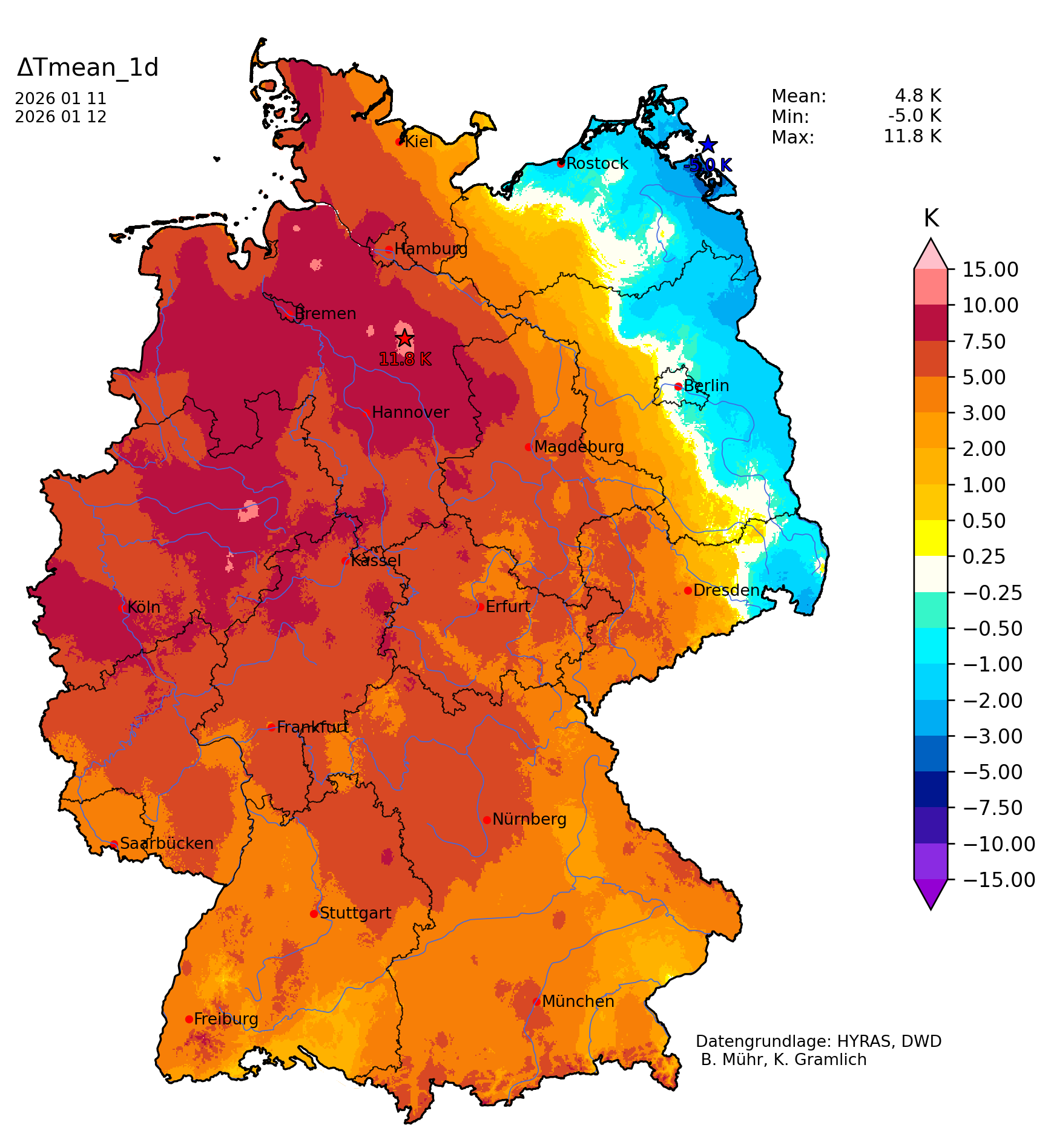
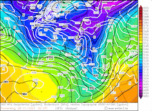
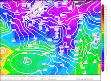
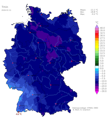
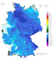
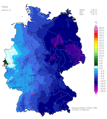
By January 10, 2026, low Elli started to move slowly southeastwards. Subsequently, colder air masses could advance southwards across Germany. Widespread fresh snow accumulations were observed. In the western hillsides, significant fresh snow accumulations occurred. In the Black Forest, fresh snow accumulations of up to 30 cm/24 h were reported. Most of Germany reported a snow cover following the passage of low-pressure system Elli. The combination of the fresh snow accumulation and the influx of much colder air masses, accompanied by clear skies, caused frigid low temperatures in the night to January 11, 2026. Widespread minimum temperatures below -15 °C were observed across the extensive snow fields in Northern Germany. The coldest temperature was recorded at Wittingen-Vorhop, NI with a minimum temperature of -18.9 °C. The daytime maximum temperatures as well were frigid on January 11, 2026. Remarkable here is also the maximum temperature at Wittingen-Vorhop, NI with a maximum of -8.1 °C.
|
Daily minimum temperature over Germany, 11.01.2026 (left), daily maximum temperature over Germany, 11.01.2026 (center left), daily minimum temperature over Germany, 12.01.2026 (center right), and 1-day mean temperature change over Germany, 12.01.2026 (right), source:
Wettergefahren-Frühwarnung
|
 |
 |
 |
 |
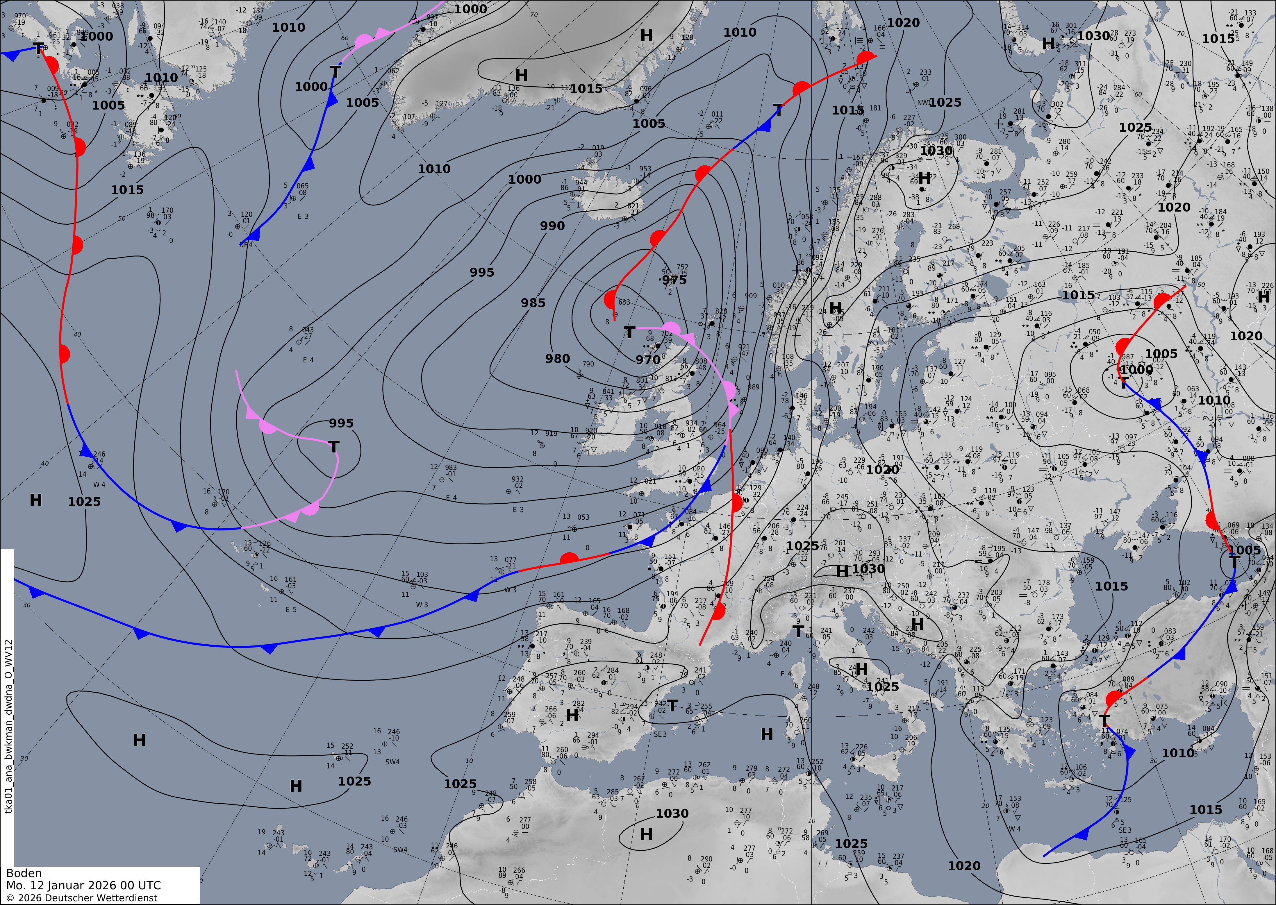
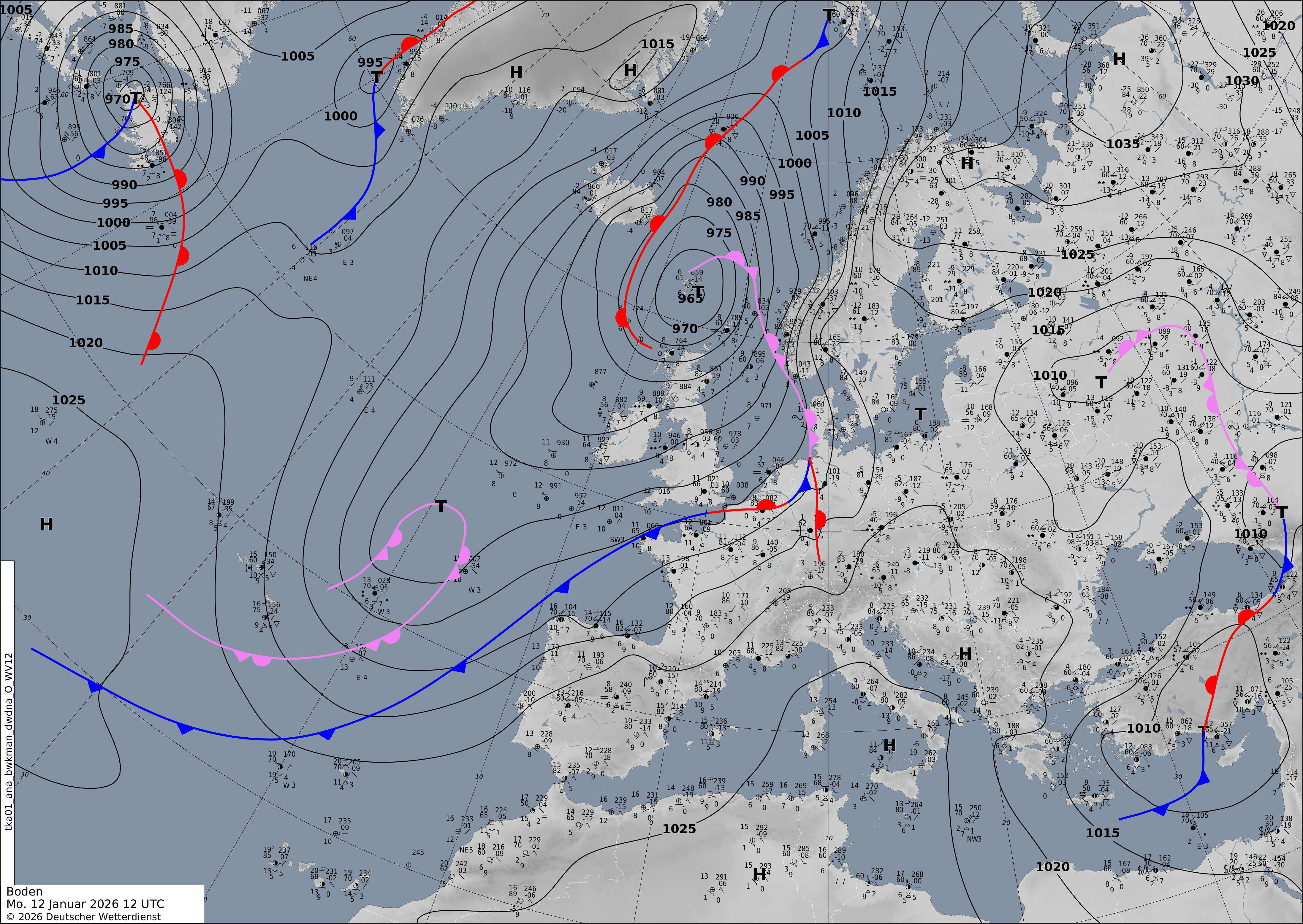
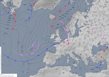
On January 11, 2026, low-pressure system Gunda approached Western Germany. The extensive warm front of the system started to impact Western Germany by midnight. At first, moderate to heavy snow was observed as the milder air masses penetrated further east at higher elevations. Concurrent with the morning commute, the precipitation across Western Germany turned into freezing rain as milder air masses penetrated to the surface. Due to the frigid day prior and the extensive cold period, the soils were still frozen, and freezing rain could accumulate. The freezing rain caused travel disruptions with further train cancellations. By midday, the freezing rain started to impact the central parts of Germany. Ahead of the warm front, frigid low temperatures were observed in the first half of the night to January 12, 2026, across Eastern Germany. Temperatures dropped to -19.6 °C at Soland/Spree, SN, and at Doberlug-Kirchhain, BB. In the night to January 12, 2026, the eastward motion of the warm front of low Gunda decreased, and milder air masses could not penetrate to the surface. Subsequently, extensive periods of freezing rain were observed in Eastern Germany, the Bohemian Basin, and Eastern Austria. Extensive freezing rain was reported in the city of Vienna.
|
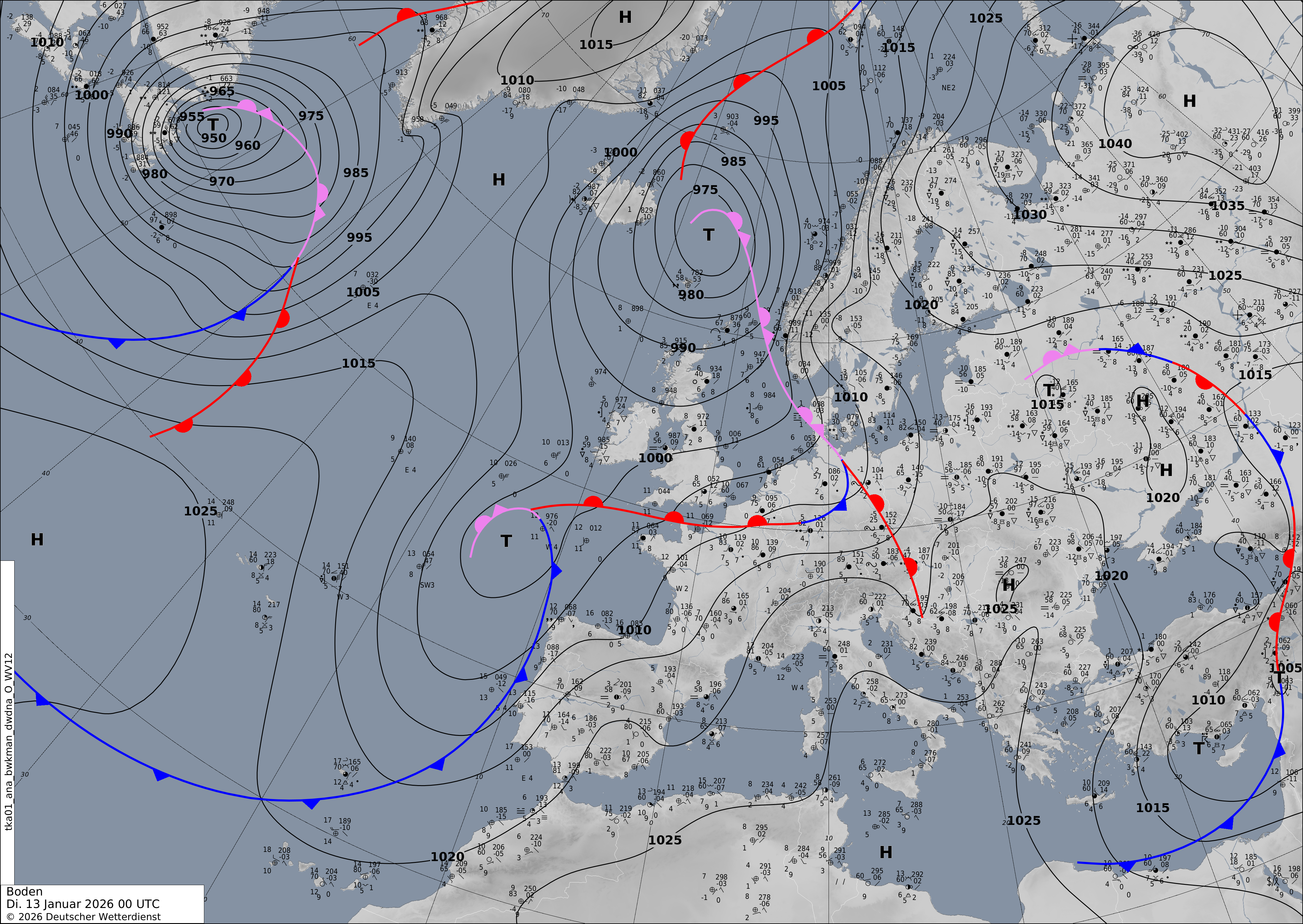
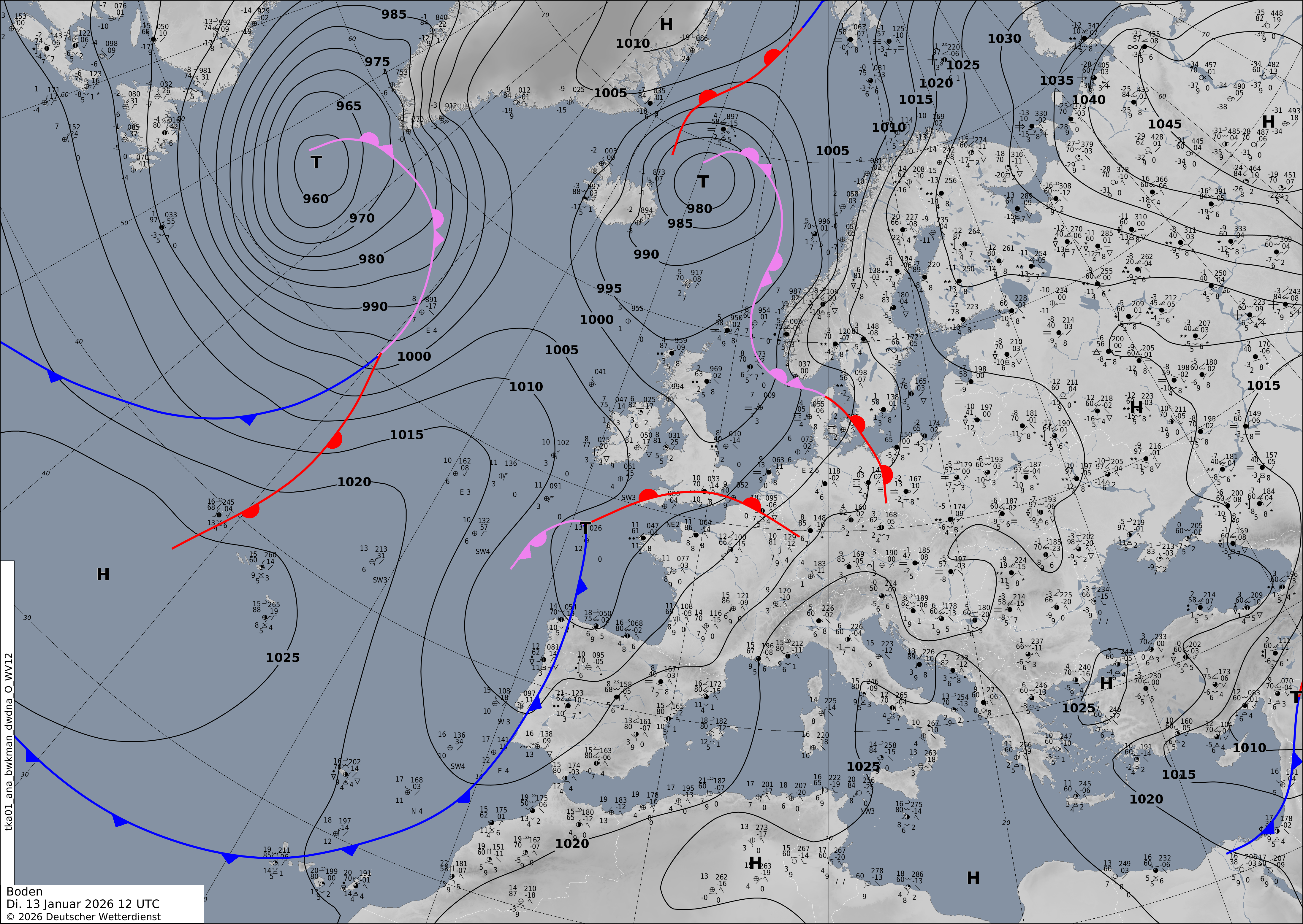
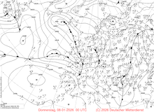
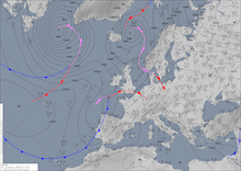
Sea-surface pressure and analyzed fronts over Europe, 12.01.2026 00 UTC - 13.01.2026 12 UTC, source:
DWD
|
 |
 |
 |
 |
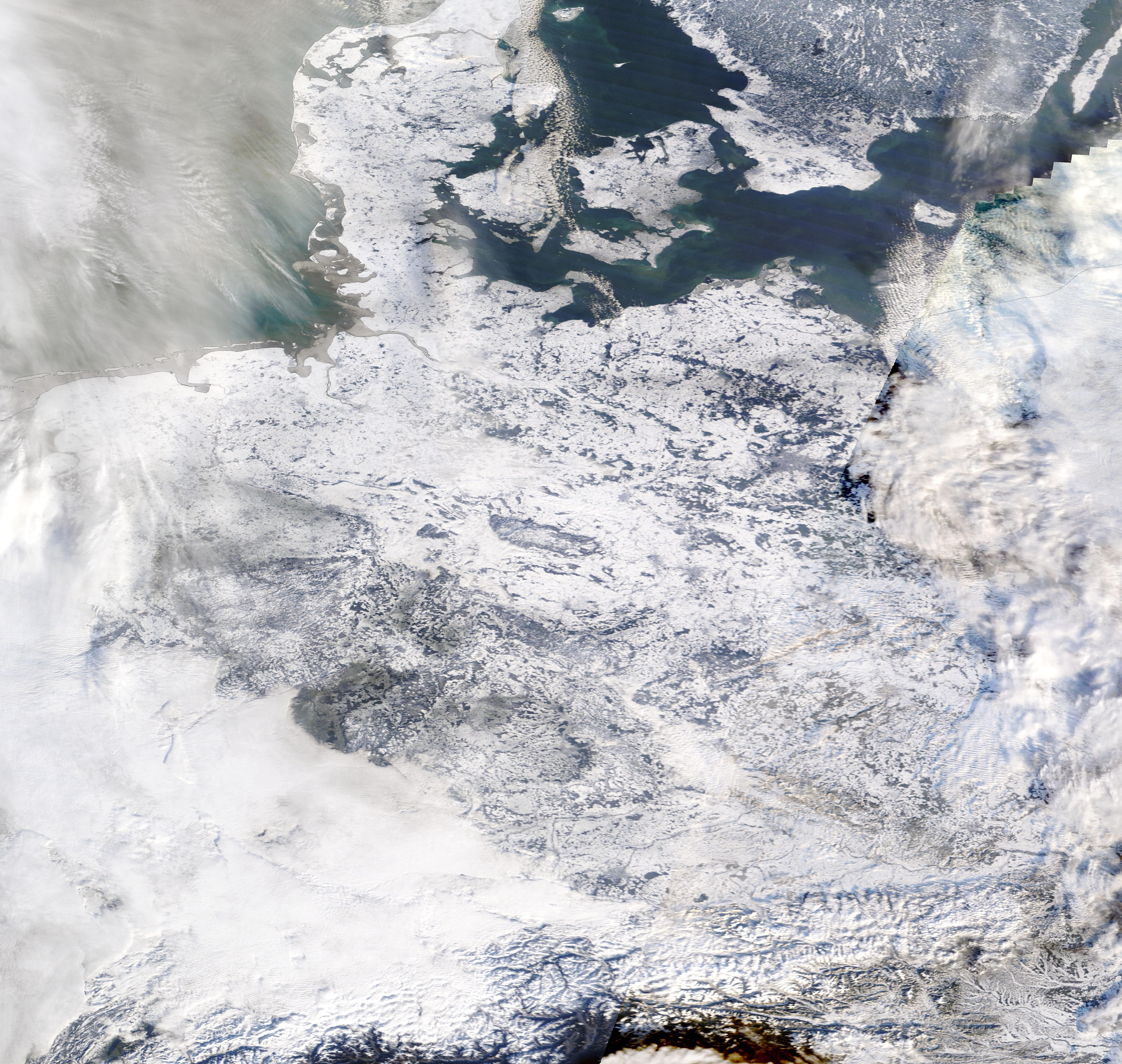
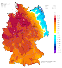
By January 13, 2026, the warm front of low Gunda had traversed Germany. Much milder air masses reached Western Germany, with local maximum temperatures above 10 °C, approaching 15 °C along the Upper Rhine. The day was the warmest in Germany since the onset of the cold period before Christmas. The average temperature deviations across Germany hovers around -3 K after the recent cold period. The largest negative deviations are observed across Eastern Germany with deviations of more than -4 K. The extensive cold period led to significant ice coverage of many waterways in Northern Germany. Drifting ice was observed along the Elbe River. Significant ice coverage started to form along sheltered areas of the Baltic Sea in Northeastern Germany, with e.g., ice coverage of the Stettiner Haff. Above freezing temperatures will melt the snow cover in most areas in the coming days, and retreating ice coverage of river, sea, and coastal ocean waters is expected.
Text: KG
January 14, 2026
|