|
Super-Typhoon RAGASA was a category 5-equivalent tropical cyclone over the Western Pacific with 1-minute sustained winds of up to 270 kph. Near peak intensity, Super-Typhoon RAGASA made landfall on Panuitan Island, part of the Babuyan Islands in the Luzon Strait. A second landfall impacted Guangdong Province in Southern China.
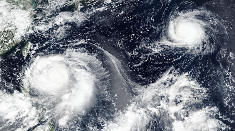
Leading up to the formation of Super-Typhoon RAGASA, the tropical cyclone activity over the Western Pacific Basin was abnormally quiet. Normally, this basin is the busiest in the world with year-round activity due to the Western Pacific warm pool. In this season, the accumulated cyclone energy (ACE) was running way below average in mid-September. No prior violent typhoon had developed in all of 2025. By September 18, 2025, two tropical depressions formed nearly simultaneously over the Western Pacific. Way to the northeast of the eventual Super-Typhoon RAGASA, the eventual Typhoon NEOGURI formed. At a latitude of 27 °N, tropical cyclone NEOGURI reached category 4-hurricane equivalent strength. Such violent tropical cyclones are a rare occurrence so far north in the tropical basins. On its erratic track, typhoon NEOGURI lost and regained typhoon-strength three times.
|
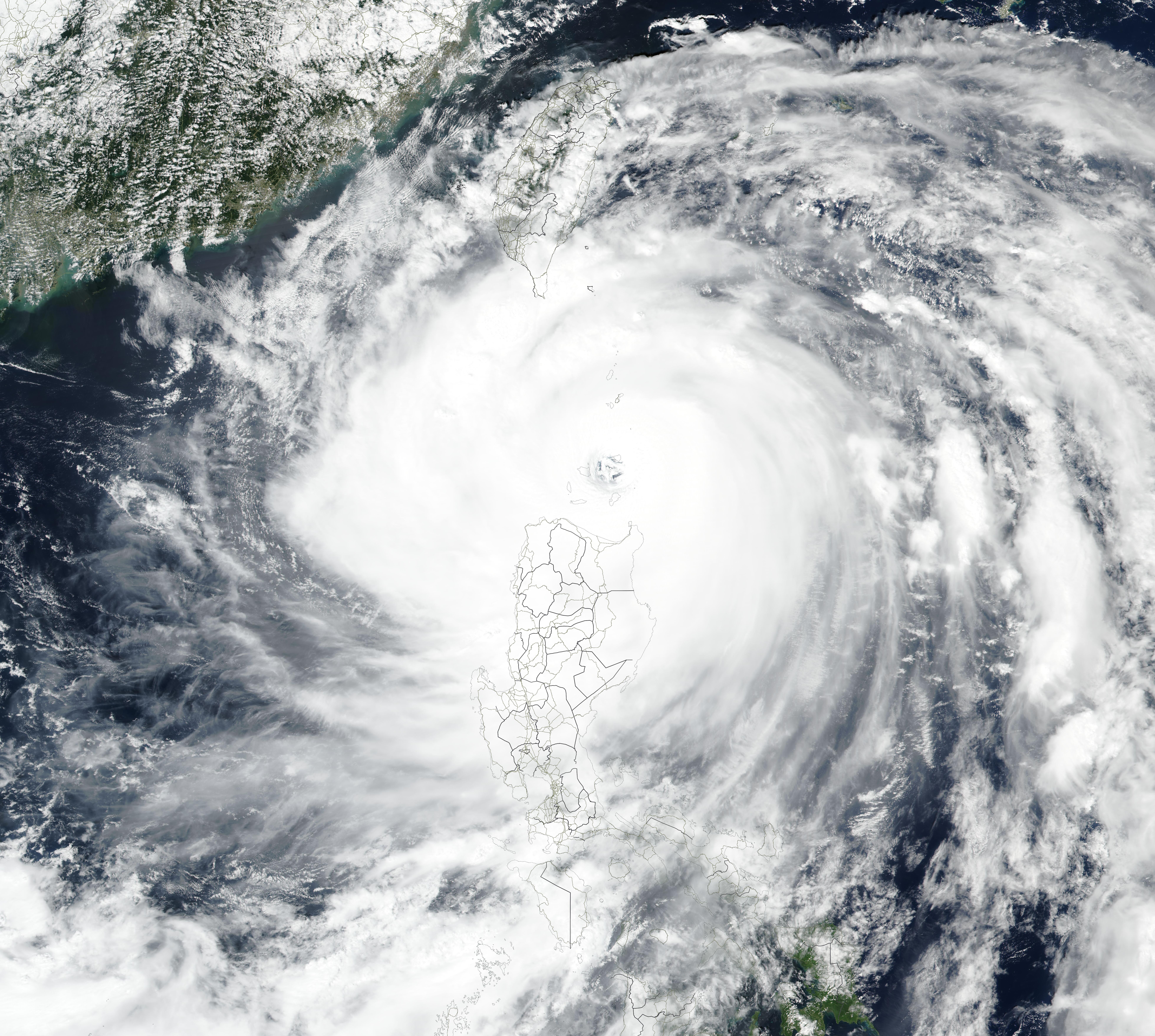
Visible satellite imagery of Super-Typhoon RAGASA and Typhoon NEOGURI over the Western Pacific, 21.09.2025, source:
NASA Worldview
|
 |
Further south over the Philippine Sea, tropical cyclone RAGASA reached tropical storm strength on September 18, 2025. On its northwesterly trajectory, the cyclone approached the Philippines. On September 20, 2025, tropical cyclone RAGASA reached typhoon strength. In the second half of September 20, 2025, an exceptionally strong rapid intensification occurred. The environment around the cyclone was very favorable. Little shear and sea surface temperatures of more than 30 °C allowed the tropical cyclone to tap into the oceanic energy reservoir. By September 21, 2025, 06 UTC, RAGASA had intensified into a super-typhoon with 1-minute sustained winds of 255 kph and a central pressure of 922 hPa. In a 24 h-period, the 1-minute sustained winds of Super-Typhoon RAGASA increased by 125 kph and the central pressure dropped by 52 hPa/24 h.
|
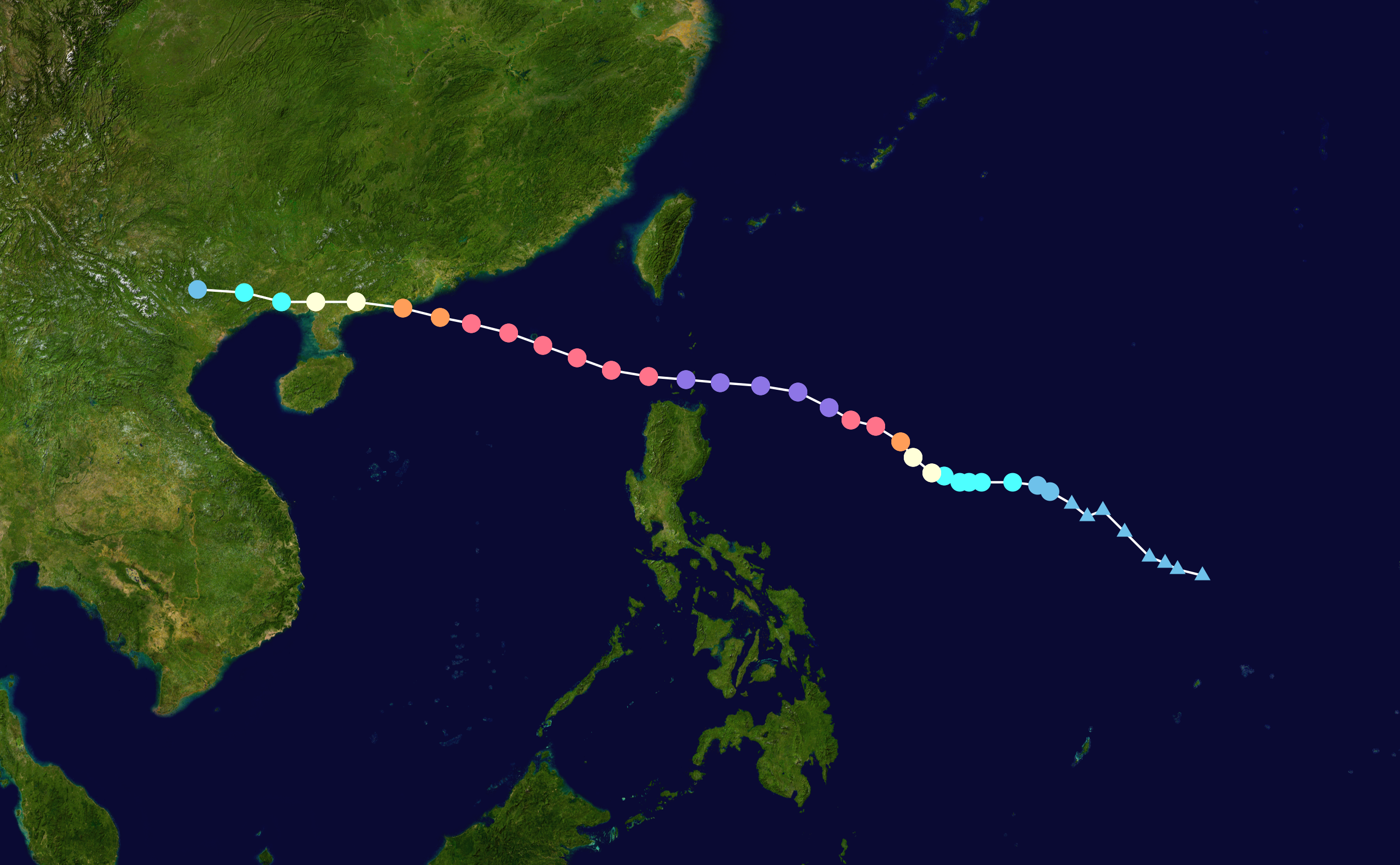
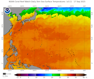
Track and intensity of Super-Typhoon RAGASA (left), source:
NASA, and SSTs over the Western Pacific ahead of the formation of Super-Typhoon RAGASA and Typhoon NEOGURI, 17.09.2025 (right), source:
NOAA Coralreefwatch
|
 |
 |
Later on September 21, 2025, an eyewall replacement cycle in the heart of the tropical cyclone occurred. In this process, the outer bands of a ferocious tropical cyclone deprive the inner eyewall of moisture. Atmospheric moisture is the engine of the tropical cyclone. Subsequently, the inner eyewall collapses, and a secondary eyewall forms with a larger diameter. As a result, the eye of the tropical cyclone typically widens during this process. This process is often accompanied by a temporary decrease in the strength of the tropical cyclone. In the case of Super-Typhoon RAGASA, the eyewall replacement cycle led only to a negligible decrease in the overall cyclone strength. The 1 min-sustained winds remained constant. The central pressure increased by only 3 hPa.
|
Infrared satellite imagery of Super-Typhoon RAGASA at landfall on Panuitan Island, 22.09.2025 07 UTC, source:
NASA Worldview
|
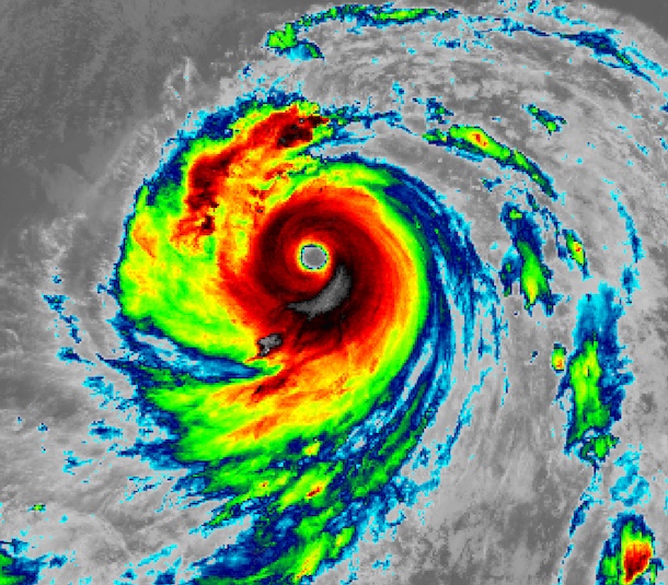 |
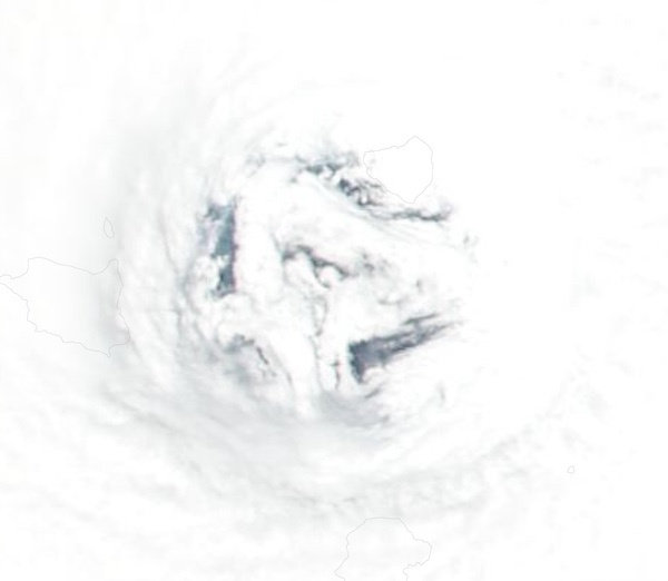
Shortly before approaching the Luzon Strait north of the Philippines, the peak intensity of Super-Typhoon RAGASA was observed on September 22, 2025, at 00 UTC. After the eyewall replacement cycle finished. The 1-minute sustained winds peaked at 270 kph with a central pressure of 910 hPa. An unofficial recording of a buoy east of the Luzon Strait measured a minimum pressure of 900.3 hPa. Before its landfall, the eye of Super-Typhoon RAGASA reached a diameter of more than 70 km. By 07 UTC, Super-Typhoon RAGASA made landfall near peak intensity on Panuitan Island in the Luzon Strait north of the main island of the Philippines. The eye of Super-Typhoon RAGASA was large enough that the entire Panuitan Island was located within the eye of the storm during landfall. Battered by violent winds and torrential rains, widespread significant damage occurred on the Babuyan Islands.
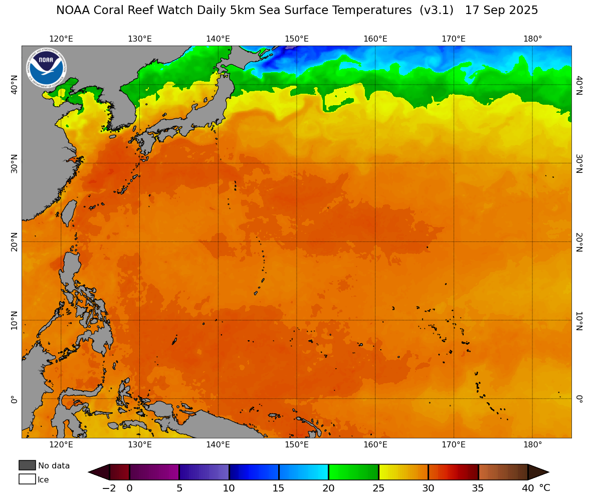
Visible satellite imagery of the mesovortices inside the eye of Super-Typhoon RAGASA prior to landfall on Panuitan Island,
22.09.2025, source:
NASA Worldview
|
 |
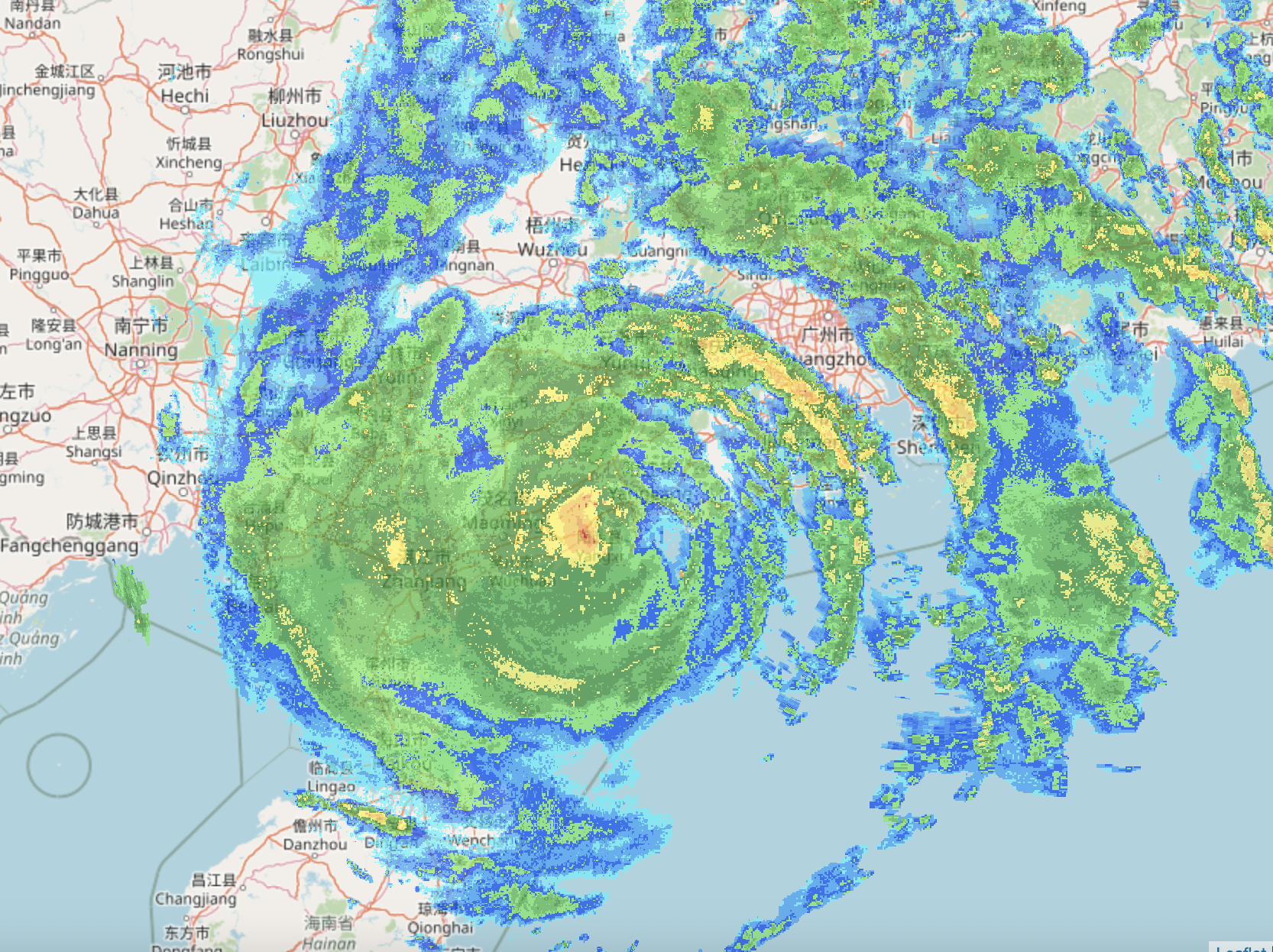
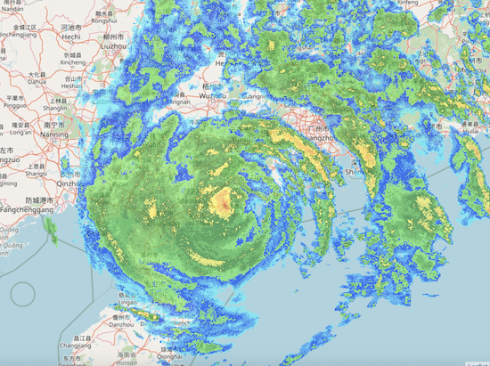
West of the Philippines, Super-Typhoon RAGASA continued on its northwesterly trajectory across the South China Sea. In the following days, the outer bands of Typhoon RAGASA reached Southern China, while the eye of the cyclone approached the coast. By September 24, 2025, Typhoon RAGASA made its second landfall in Southern China around 100 km west of the Hong Kong/Macau metropolitan area. Upon landfall, the cyclone brought torrential rains. Onshore winds induced a storm surge of up to 3 m in Hong Kong, inundating parts of the city. After landfall, the trajectory of Typhoon RAGASA remained close to the coastline. The proximity to the South China Sea and the wet forest land of Southern China allowed Typhoon RAGASA to retain typhoon-strength for more than 12 h after landfall. The surface low of Typhoon RAGASA eventually dissipated over Northern Vietnam on September 25, 2025, about 100 km north of Hanoi.
|
Radar image of Typhoon RAGASA approaching Southern China, source:
Festivalwetter
|
 |
In total, Super-Typhoon RAGASA led to at least 28 fatalities and around $100 million in damages. Though most of the damage occurred far from the actual path of the cyclone. North of the typhoon, the persistent easterly winds of the circulation caused torrential rains in Southern Taiwan. Precipitation totals of more than 500 mm were observed in the rugged terrain of the eastern half of the island. In Hualien County, a barrier lake broke. The Matai’an Creek barrier lake formed earlier this year after a major landslide blocked the creek following heavy rains brought by Tropical Storm WIPHA. A catastrophic flood impacted downstream areas, killing at least 17 people in the county and causing major damage.
Text: KG
September 29, 2025
|