|
Hurricane HILARY has become the first tropical system to directly impact California since Hurricane NORA in September 1997, which moved over the lower Colorado Basin and dissipated in the Arizona-Nevada border region. HILARY brought at many places record-breaking precipitation to the Desert Southwest.
The tropical disturbance eventually maturing into Hurricane HILARY formed on August 12, 2023, from a tropical wave moving over the Eastern Pacific. In the following days, the system slowly organized, reached tropical storm strength on August 16, 2023, named HILARY. The system was initially on the typical trajectory for tropical cyclones in the Eastern Pacific Basin, moving northwestwards away from the American Continent.
500 hPa Geopotential (upper row) and 850 hPa pseudo-potential temperature (lower row) along with the sea surface pressure over Northern America,
19.08.2023 12 UTC - 21.08.2023 00 UTC, source:
wetter3
|
 |
 |
 |
 |
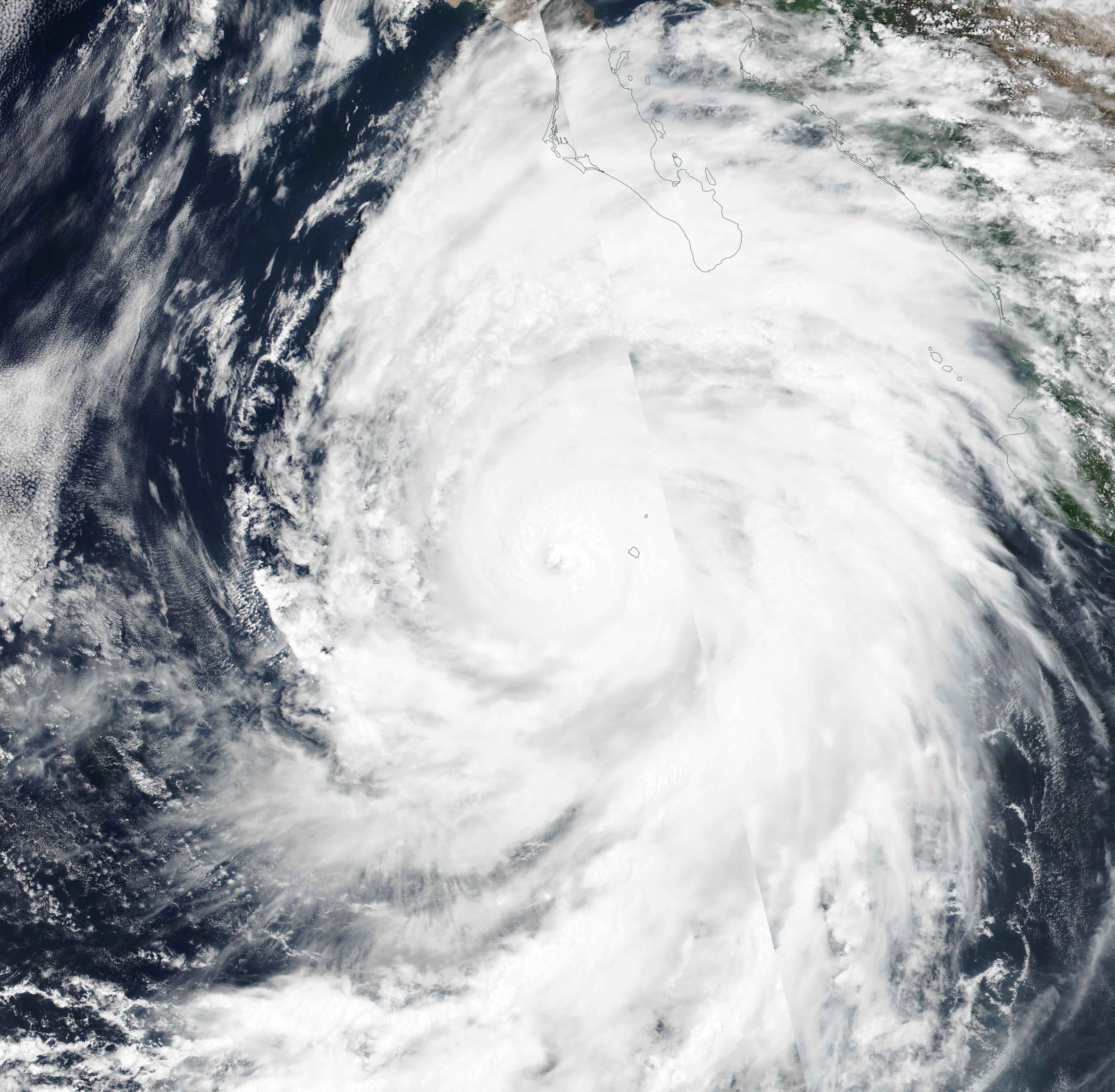
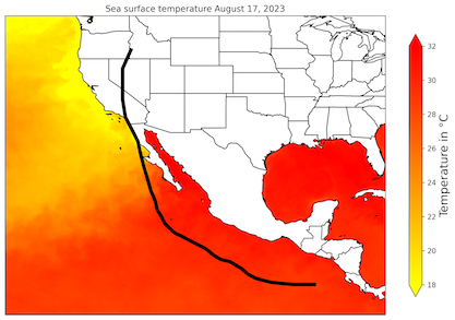
After reaching tropical storm strength, HILARY moved into a region favorable tropical cyclone intensification with sea surface temperatures reaching up to 30 °C and quickly reaching hurricane-strength on August 17, 2023. Within a 18 h period, HILARY intensified into a category 4-hurricane, with sustained winds peaking at 230 kph and the central pressure dropping to 939 hPa on August 18, 2023. On the same day, the hurricane started to interact with the mid-latitude dynamics.
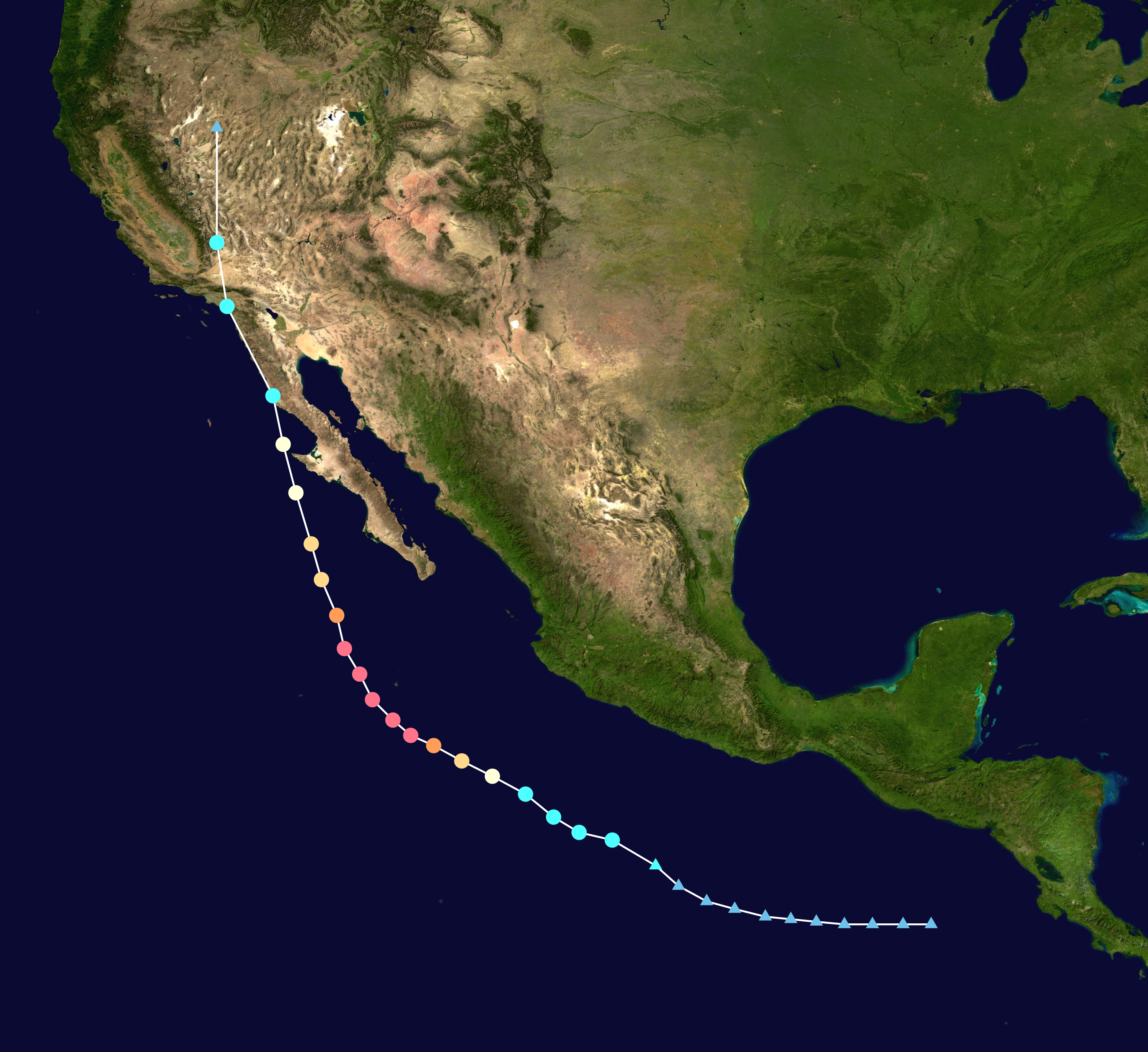
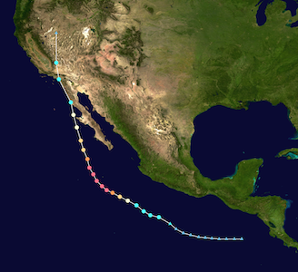
Sea surface temperature and track of Hurricane HILARY (left), source: NOAA NESDIS, Visualization: K. Gramlich,
track and intensity of Hurricane HILARY (right), source:
NASA
|
 |
 |
An exceptional weather pattern across the western part of the US deviated HILARY from the typical track of tropical cyclones over the Eastern Pacific. The combination of a strong trough off the coast of California and an exceptionally strong ridge expanding over the Midwest forced HILARY on a more northerly track, nearing the Mexican coast. The combination of increasing shear and cooler ocean waters led to the gradual weakening of Hurricane HILARY. Nevertheless, the exceptional track of Hurricane HILARY made extensive preparation necessary in the southern part of California as the rare impact of a tropical cyclone was expected.
|
7-day mean 500 hPa geopotential (left) and 500 hPa geopotential anomaly (right) over the US, source:
PSL NOAA
|
 |
 |
By August 20, 2023, the weakened hurricane moved nearly parallel to the coast of the Baja California, with tropical moisture already causing heavy showers in the Desert Southwest. First flash flooding was already reported from the Las Vegas region due to strong downpours forming in the moister air. By 10:30 UTC, Hurricane HILARY made first landfall over the Baja California briefly touching the coast. By 18 UTC, the second landfall of then tropical storm HILARY was observed in San Quintín, Baja California, around 350 km south of San Diego, CA. In the following hours, HILARY continued to move north-northeastwards over the Baja California, moving across the US-Mexican border in the Tijuana-San Diego metropolitan area. Further north, the center of the tropical storm moved over Oceanside, CA, and the Los Angeles Basin. After moving further inland, HILARY degenerated into a post-tropical cyclone, quickly moving northwards along the eastern flank of the ridge over the Midwest.
Upon landfall, Hurricane HILARY brought high winds and intense precipitation to Baja California. Widespread flash flooding and many mudslides were reported from the mountainous peninsula, blocking many roadways. By late August 20, 2023, the swath of tropical moisture from Hurricane HILARY moved northwards into the desert regions of Southern California. Here, heavy rain caused many flash floods. Many parts of the Imperial Valley and the Inland Empire saw more than half of their annual precipitation fall within a few hours. The region is one of the driest in the US, with annual precipitation totals around 50 – 75 mm. Nevertheless, the Imperial Valley provides a significant proportion of the US crop production due to irrigation, making flash flooding in this region especially costly.
|
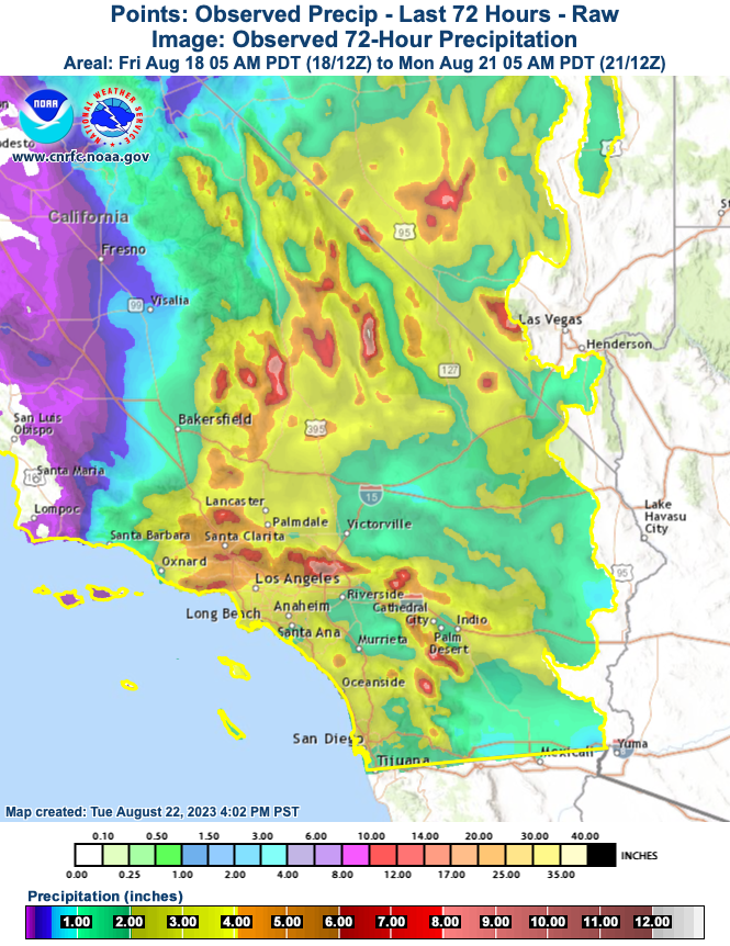
72 h-precipitation totals over Southern California, source:
CNRFC
|
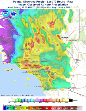 |
In the mountainous terrain of Southern California, precipitation totals reached up to 298 mm at Mount San Jacinto in the San Jacinto Mountains. The intense precipitation led to high run-off along many rivers feeding into the Pacific Ocean, with many rivers running at record levels for the summer months. At the foot of Mount San Jacinto, heavy precipitation fell in Palm Springs, CA, setting a new daily precipitation record of 80.8 mm, which accounts for 68 % of the annual precipitation, leading to widespread flash flooding. The nearby Joshua Tree National Park was already closed on August 19, 2023, in anticipation of the severe flash flooding potential. As a result of the heavy precipitation many mudslides were reported from Southern California, temporally blocking nearly every major roadway in the region.
The city of Los Angeles, CA also recorded exceptionally high precipitation totals for the month of August, with many stations breaking the daily precipitation records for the month of August set in 1977 when the remands of Hurricane DORA passed over Southern California. The 1991 - 2020 climatology for Downtown LA has a 0.0 mm monthly rain total for the month of August, with Hurricane HILARY bringing 63 mm of rain to the station alone. As a result of this one storm alone, the new climatology will disclose significant precipitation for the month of August. In the mountains north of the city, the highest wind gusts related to Hurricane HILARY was observed at the Magic Mountain Truck Trail, where wind gusts peaked at 140 kph. As a result of the impacts of Hurricane HILARY, all schools in the LA district were closed on August 21, 2023.
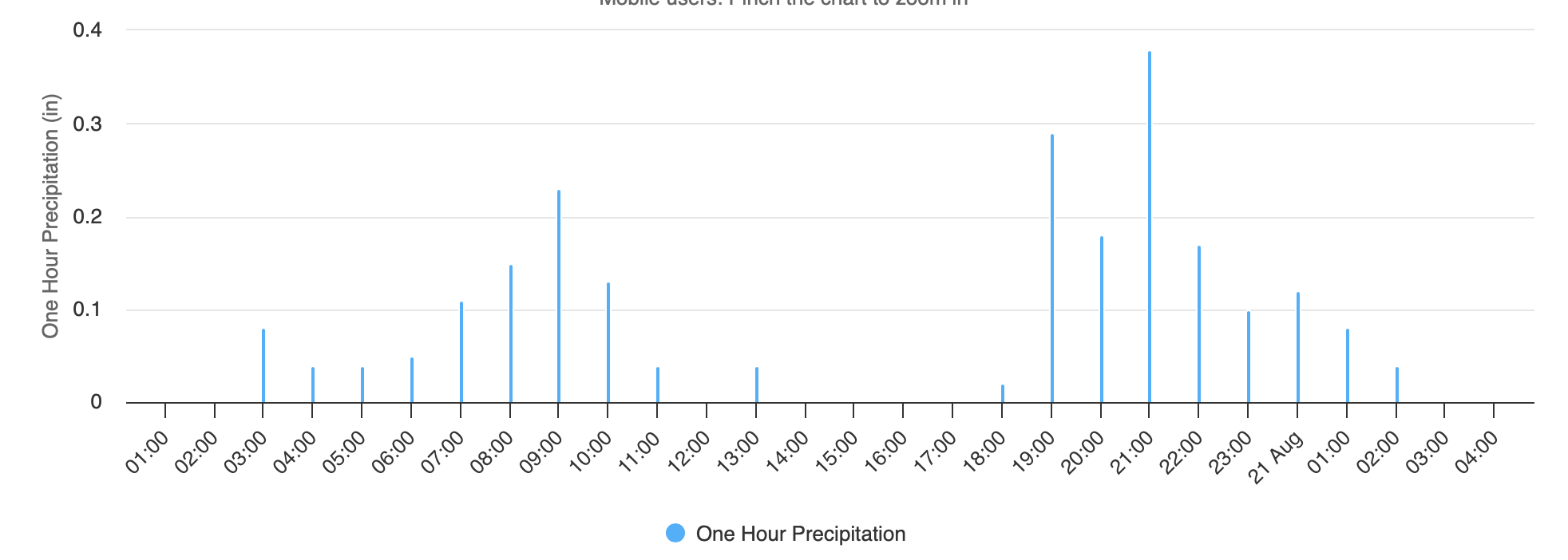
|
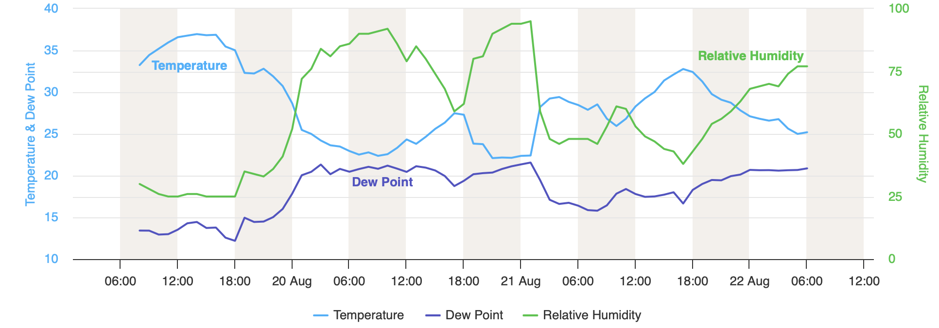
Temperature and dew point (upper figure) and hourly precipitation totals (lower figure) at Badwater Basin, CA, 19.08.2023 15 UTC - 22.08.2023 13 UTC, source:
NWS
|
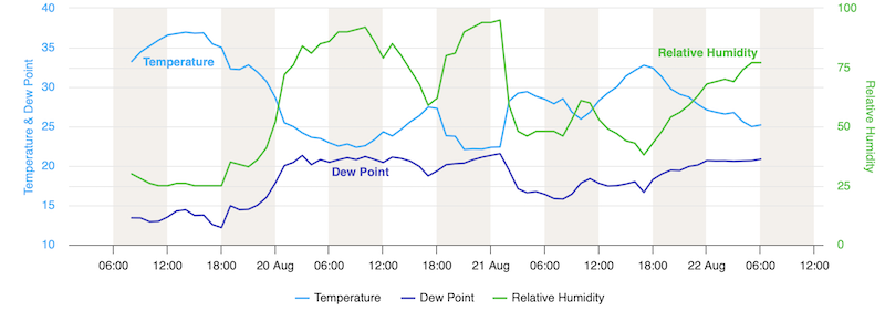 |
With the remands of HILARY moving northwards, intense precipitation also affected the southern part of the Sierra Nevada. In the Death Valley, CA continuous precipitation fell throughout the day, accumulating up to 55.9 mm of rain on the valley floor at a rain gauge near Furnace Creek, CA. This accounts for nearly 100 % of the annual precipitation and shatters the daily precipitation record set just last year on August 05, 2023, when a local thunderstorm dumped more than 40 mm of rain onto the valley floor. The rain led to widespread flash flooding in the park, with many roads being washed out once again. Furthermore, the continuous precipitation also led to temperatures far below average in regions which are accustomed to summer days reaching more than 45 °C. Temperatures on August 20, 2023, topped at 27 °C at Badwater Basin, CA, day-time high-temperatures here normally expected at the beginning of November.
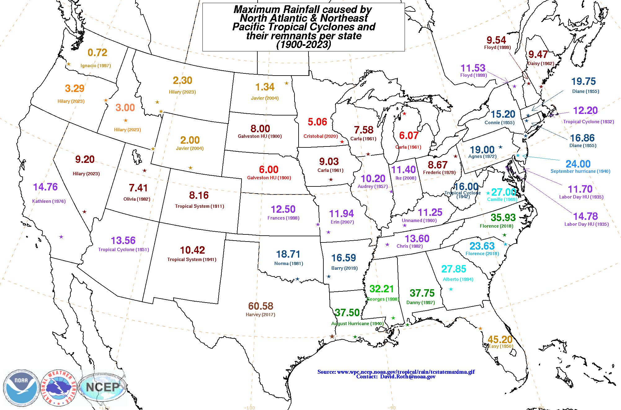
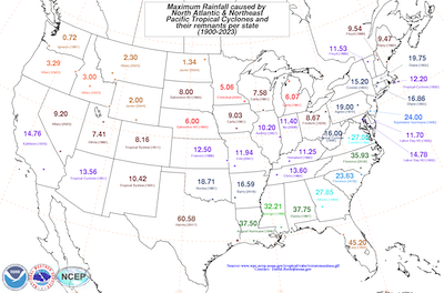
Heavy precipitation continued to spread into Nevada, where heavy precipitation at Mount Charleston, NV destroyed the road leading to the town. As the remands of Hurricane HILARY, moved around the ridge over the Midwest, heavy precipitation fell across many states in the western half of the US. Many states broke their respective all-time records for tropical storm-related precipitation (NV: 233.7 mm, OR: 83.6 mm, ID: 76.2 mm, MT: 58.4 mm).
|
Statewise tropical storm-related precipitation records across the US, source:
NWS
|
 |
Over the Midwest, the exceptional strong ridge brought unbearable heat to parts of the Great Plains with many new daily records being set. Locally, the heat index reached way above the 50 °C-mark, with temperatures reaching more than 40 °C and dew points close to the 30 °C-mark.
With its rare track into the Desert Southwest, Hurricane HILARY became the first hurricane to affect California and the Desert Southwest since Hurricane Nora in September 1997. Which makes Hurricane HILARY not as rare as anticipated, as there was no landfall observed in California. The last tropical storm to make landfall in California was the 1939 California tropical storm, with the last hurricane likely making landfall in California being the 1858 San Diego hurricane. Nevertheless, Hurricane HILARY was an exceptional occurrence, breaking many precipitation records in the western half of the US, with the mid-latitude dynamics bringing sweltering heat to the Midwest.
Text: KG
August 22, 2023
Information on warning levels and icons used
Information on meteoalarm.eu
|