Sunday, February 22, 2026, 22:00 UTC
|
|
|
|
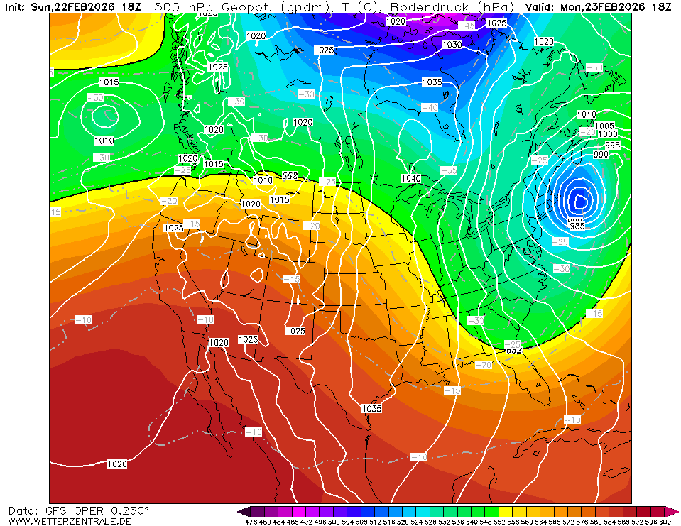
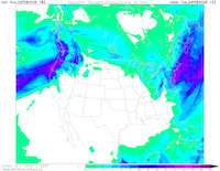
500 hPa geopotential and mean sea level
pressure over Northern America,
23.02 18 UTC
Source: wetterzentrale
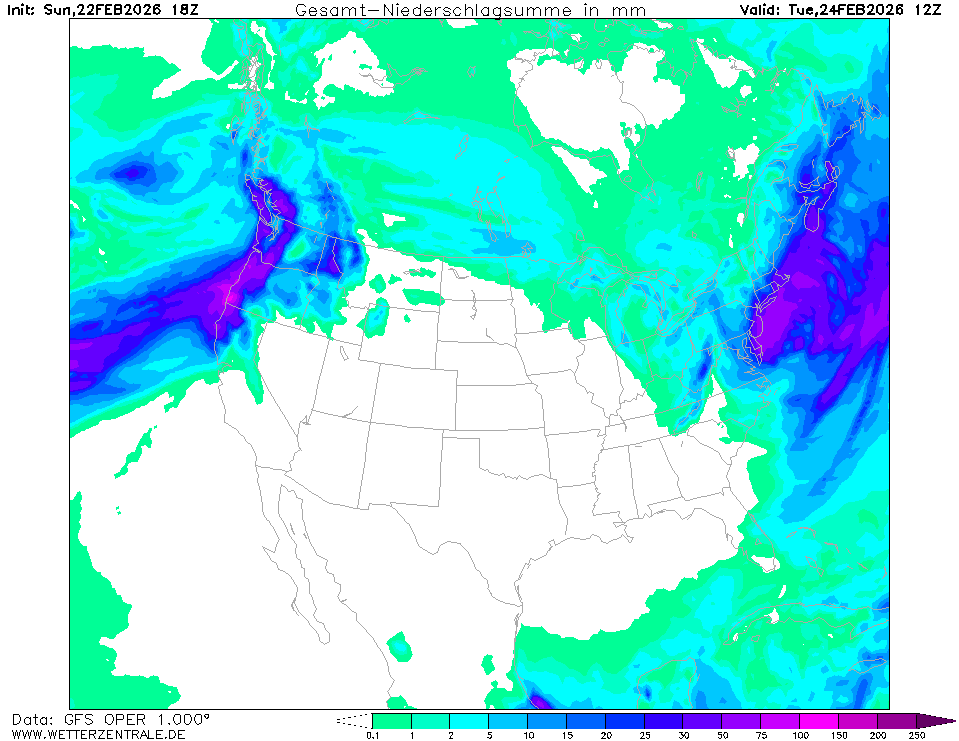
| Accumulated precipitation over
Northern America,
24.02 06 UTC,
Source: wetterzentrale
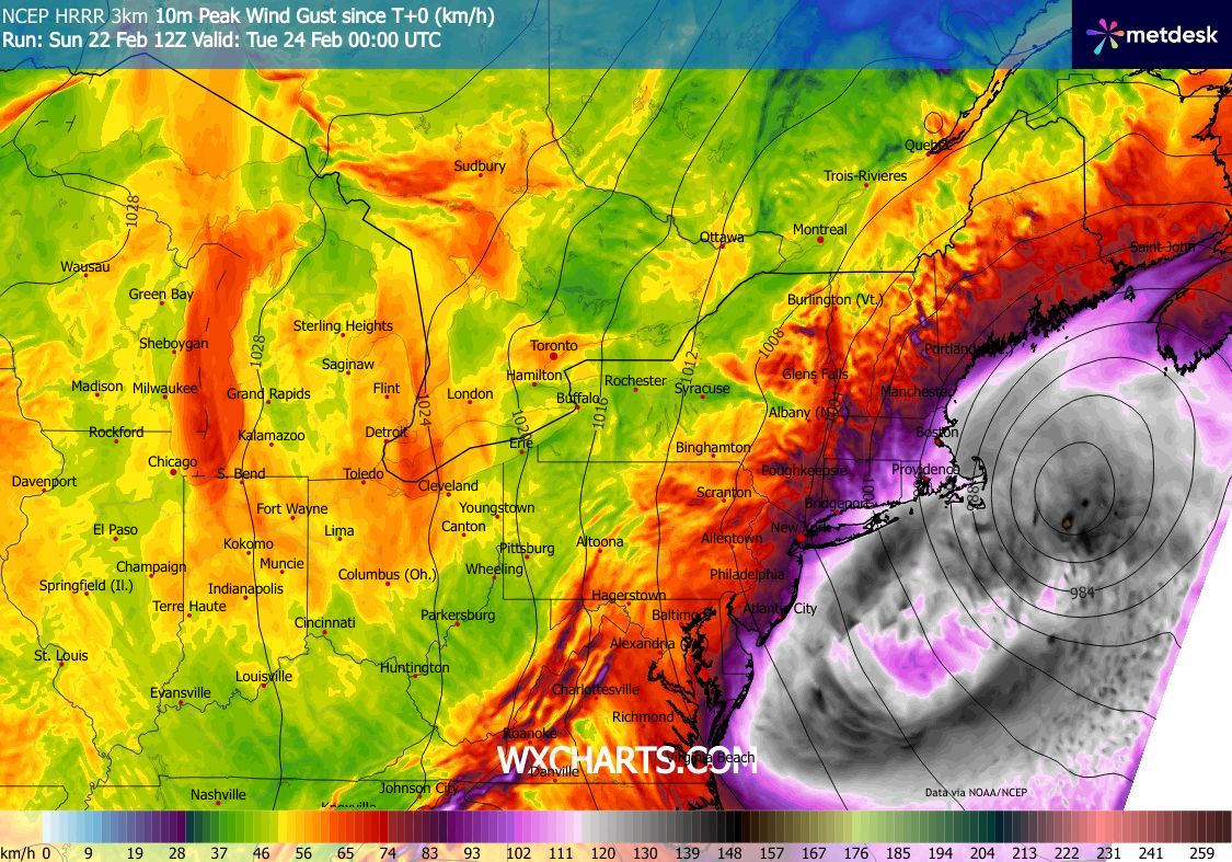
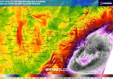
| 10 m peak wind gusts along the US East Coast,
until 24.02 00 UTC
Source: wxcharts
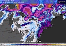
| Snow depth along the US East Coast,
23.02 15 UTC,
Source: wxcharts
|
Blizzard
US East Coast
Issued: Sunday, February 22, 2026, 22:00 UTC
A bomb cyclone off the US East Coast is forecasted to dump very large amounts of snow along the East Coast on Sunday, February 22, 2026, and Monday, February 23, 2026. Widespread fresh snow accumulations of more than 30 cm are possible throughout the densely populated Megalopolis stretching from Washington DC to Boston along the I-95 corridor.
22.01.2026
A strong meridional synoptic pattern is dominating across the US. After a week of very heavy snowfall along the US West Coast, a large ridge has expanded across the Rocky Mountains. Over the Midwest, a large trough has plunged southwards. At the leading edge of said trough, a rapidly deepening low-pressure system has developed off the coast of the Mid-Atlantic states. With its center off the coast of Virginia, the low-pressure system is forecast to undergo explosive cyclogenesis until Monday morning. During this phase of explosive cyclogenesis, it is expected that the warm front of the cyclone will wrap around the cyclone center, reaching inland.
Along the bent-back warm front, heavy precipitation must be expected. There will be a sharp transition between mostly liquid precipitation and heavy snow. Current forecast guidance suggests that most of the affected areas will experience only snow. Along the bent-back warm front, heavy snow is impacting an area stretching from Northern Virginia over Western Pennsylvania, Delaware, New Jersey, New York, and into the Boston Metropolitan Area along the I-95 corridor. In the entire area, fresh snow accumulations of up to 30 cm must be expected. In New Jersey and the New York City metropolitan area, fresh snow accumulations of up to 50 cm may be observed by Monday evening. Traveling conditions along the I-95 corridor will be treacherous to nearly impossible, with persistent hourly fresh snow accumulations of more than 5 cm/h. Depending on the severity of the storm, New York City may see one of the most severe winter storms in recent decades. Along Long Island and Cape Cod, hurricane-force winds will create blizzard conditions with wind gusts of more than 120 kph. Travelling disruptions along the I-95 corridor will likely last well into the coming week.
Sunday, February 22, 2026, 22:00 UTC
KG
|