Tuesday, October 28, 2025, 11:00 UTC
|
|
|
|
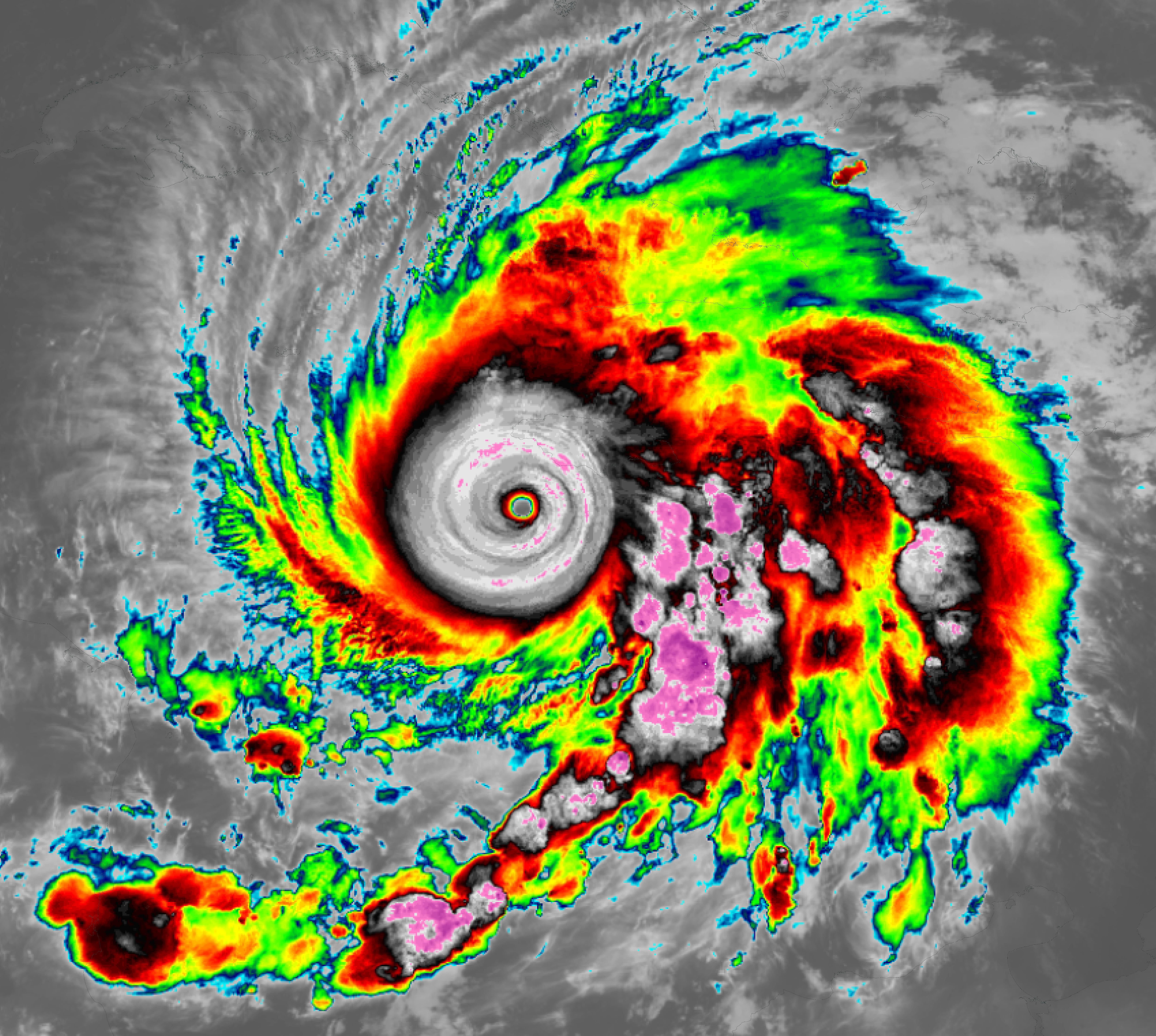
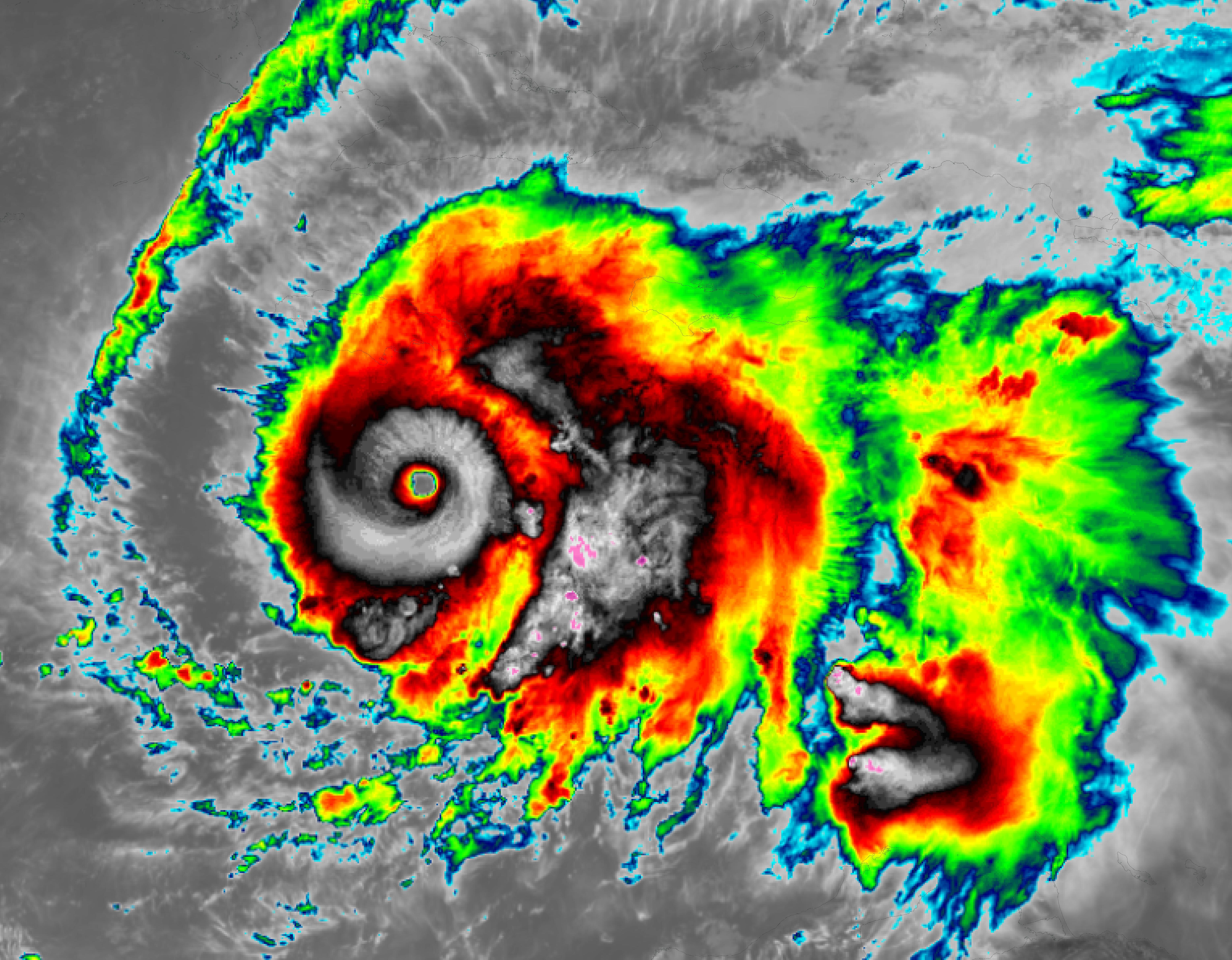
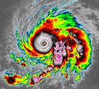
Infrared imagery of
Major Hurricane MELISSA
south of Jamarica,
26.10 17 UTC
Source: NASA Worldview
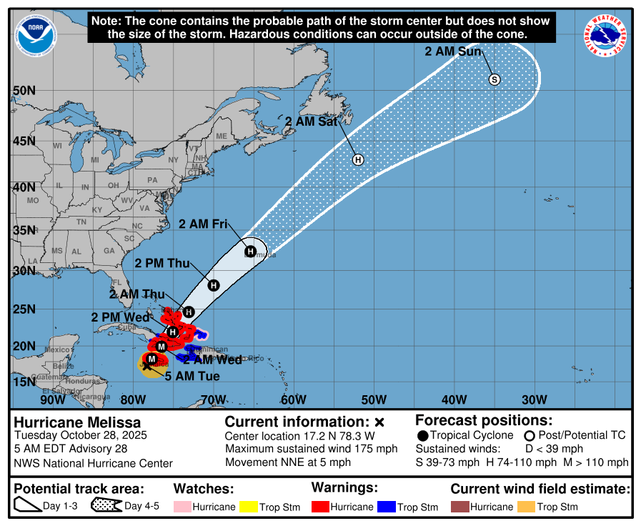
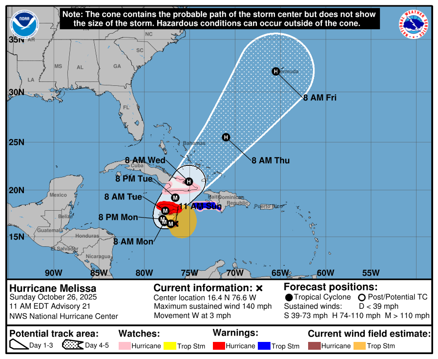
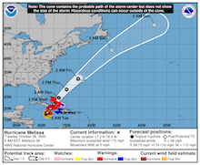
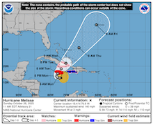
| Track and intensity guidance
for Major Hurricane MELISSA,
26.10 15 UTC
Source: NHC
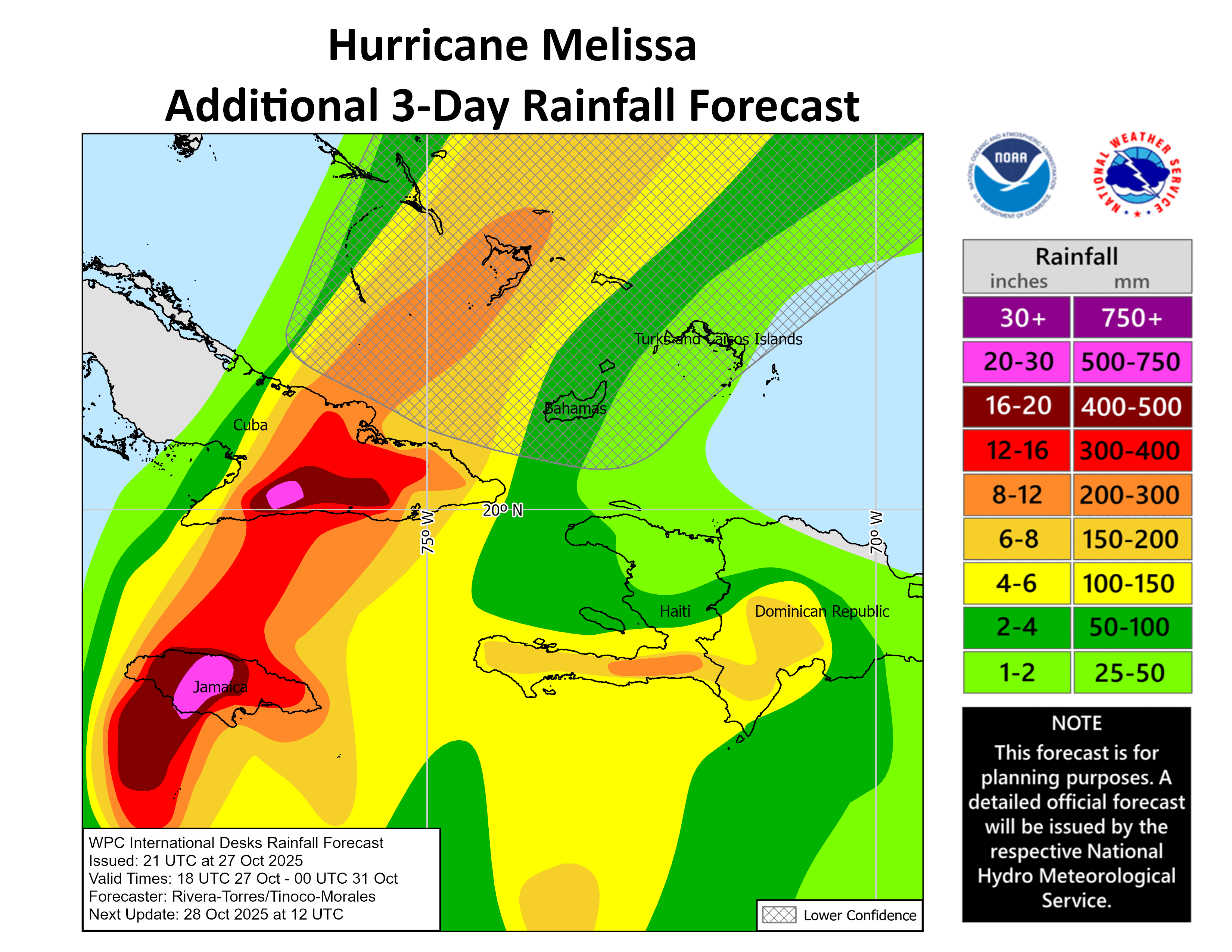
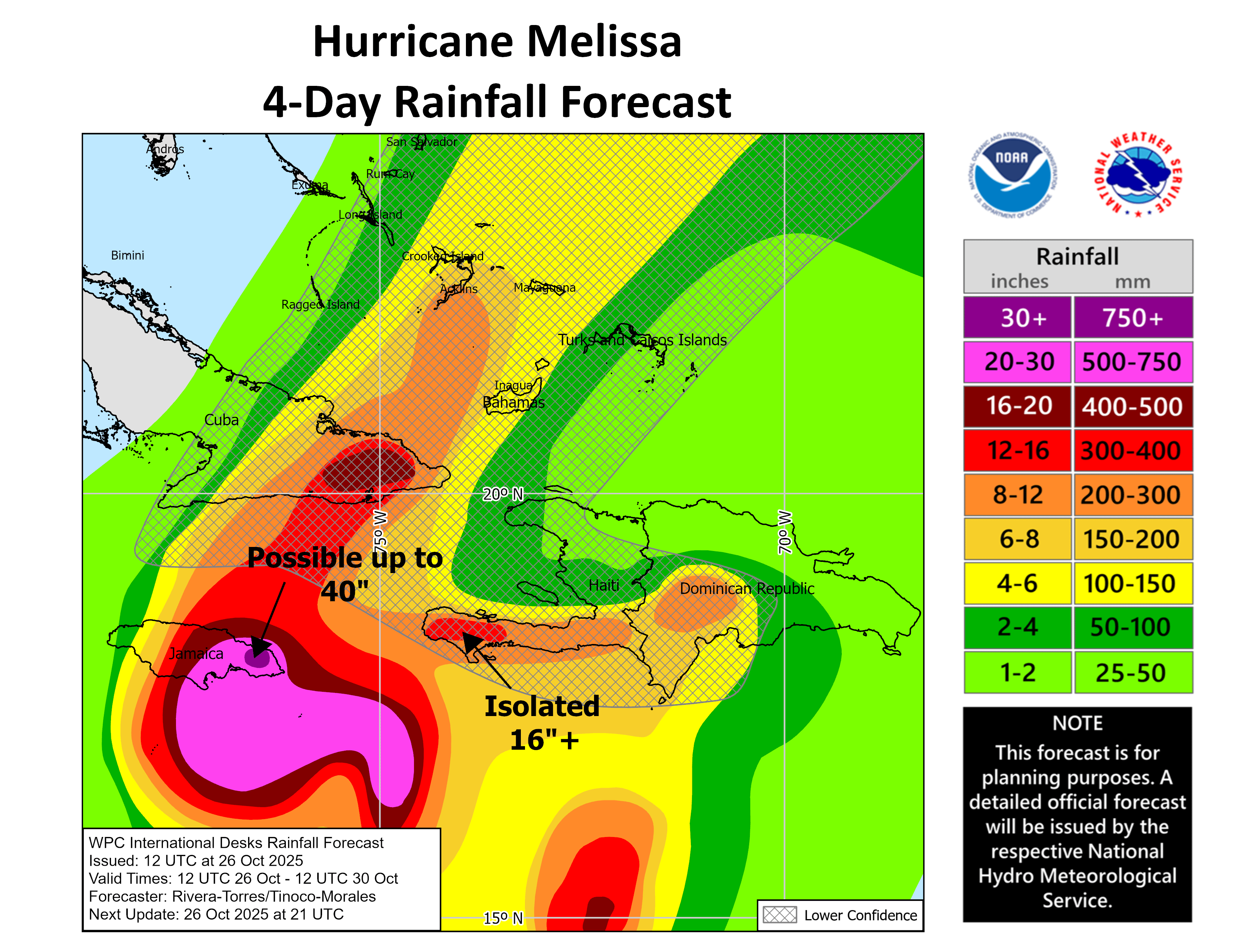
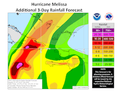
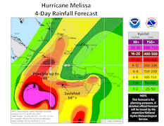
| Forecasted 4-day precipitation totals
across Jamaica, Hispaniola, and Cuba,
26.10 12 UTC
Source: NHC
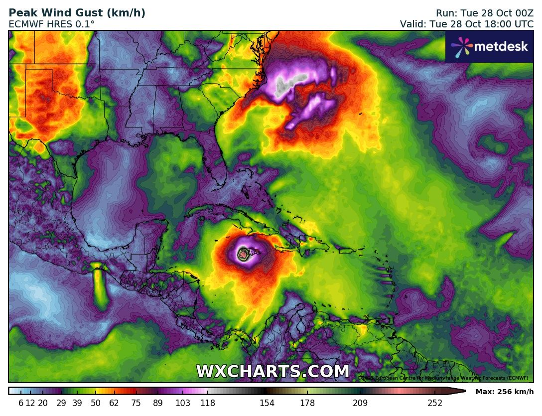
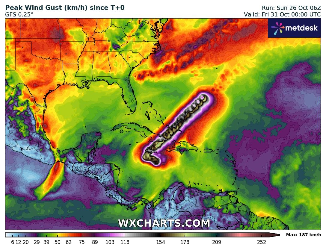
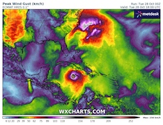
| Peak 10 m across the Caribbean
until 31.10 00 UTC
Source: wxcharts
|
Tropical cyclone
Jamaica, Cuba, Bahamas
Issued: Tuesday, October 28, 2025, 11:00 UTC
Major Hurricane MELISSA is a high-end category 5 hurricane among the most powerful ever to be observed over the Atlantic Ocean. Near peak intensity, MELLISA is expected to make landfall later today, October 28, 2025, in Jamaica. Violent winds of more than 250 kph are likely. In addition, torrential rains with totals of 750 mm will lead to extreme flash flooding and mudslides.
28.10.2025
Since the last forecast advisory of Major Hurricane MELISSA, the hurricane has intensified further. Infrared satellite imagery shows an immaculate structure of the eye wall around the nearly perfectly round eye of the storm. Dvorak-based satellite analysis for Hurricane MELISSA is near the peak of what is possible to achieve over the Caribbean. Currently, MELISSA is rated above T8.0. Such a rating is only achieved for the most violent tropical cyclones on planet Earth. Latest forecast guidance of the National Hurricane Center (NHC) positions the eye of Hurricane MELISSA around 100 km south of Jamaica. The hurricane is moving slowly to the northeast at 8 kph. Since yesterday evening, sustained winds remain constant at 280 kph with gusts of more than 300 kph. The central pressure is estimated to be 901 hPa. This is the 8th lowest central pressure ever recorded over the Atlantic.
Latest forecast guidance suggests that Major Hurricane MELISSA will make landfall later today, October 28, 2025, along the central part of Jamaica. Most likely landfall point is currently estimated to be between Alligator Point to the east and Black River to the west. Jamaican radar imagery shows that the inner eyewall of Hurricane MELISSA is still in a very healthy shape with no sign of an eyewall replacement cycle currently. Due to the enormous ocean heat content ahead of Jamaica, Hurricane MELISSA will likely retain its devastating intensity. The hurricane may even reach sub-900 hPa central pressures before landfall.
Upon landfall, MELISSA will bring violent winds with gusts of up to 300 kph in the hilly terrain of Jamaica and a dangerous storm surge. However, most devastating will be the extreme rains that will continue to impact Jamaica until at least tomorrow, October 29, 2025. Precipitation totals of more than 750 mm are possible. The torrential rains will lead to extreme flash and river flooding. Countless mudslides in the hilly terrain of Central Jamaica are to be expected. Major Hurricane MELISSA will be to most intense hurricane to make landfall in Jamaica in recorded history.
Ahead of a strengthening mid-level trough over the Southeastern US, the forward motion of Major Hurricane MELISSA will increase considerably tomorrow. Early on October 29, 2025, MELISSA will make a second landfall in Southeastern Cuba near Santiago de Cuba. Despite the landfall in Jamaica, Hurricane MELISSA will remain at major hurricane status with predicted sustained winds of more than 200 kph. Violent winds, a dangerous storm surge, and torrential rains will also impact Southeastern Cuba. In the night to October 30, 2025, a third landfall of Hurricane MELISSA is expected in the Southern Bahamas. After the passage of Cuba, the intensity of Hurricane MELISSA is anticipated to drop to a category 2 hurricane upon landfall. Nevertheless, the potentially violent impacts of Hurricane MELISSA on the Bahamas and the Turks and Caicos Islands should not be underestimated.
Sunday, October 26, 2025, 18:00 UTC

|
|
|

|
Infrared imagery of Major Hurricane MELISSA
south of Jamarica,
28.10 10:10 UTC
Source: NASA Worldview
| Track and intensity guidance
for Major Hurricane MELISSA,
28.10 09 UTC
Source: NHC
| Forecasted 3-day precipitation totals
across Jamaica, Hispaniola, and Cuba,
27.10 21 UTC
Source: NHC
| Peak 10 m across the Caribbean
at landfall of Hurricane MELISSA
28.10 18 UTC
Source: wxcharts
|
Tropical cyclone
Jamaica, Hispaniola, and Cuba
Issued: Sunday, October 26, 2025, 18:00 UTC
Major Hurricane MELISSA is threatening Jamaica and Hispaniola with violent winds and torrential rains. Extreme precipitation totals of up to 1000 mm within 2 to 4 days are likely. A category 5 landfall of Major Hurricane MELISSA near Kingston is possible on Tuesday, October 28, 2025. Subsequently, MELISSA will move to the northeast. A second major hurricane landfall near Santiago de Cuba is likely.
26.10.2025
Tropical disturbance MELISSA has been lingering across the Southern Caribbean since October 21, 2025. In the past days, the track of MELISSA has been very erratic due to a very slow forward motion of the storm. High shear and dry air intrusions have prevented an earlier development of MELISSA. Only in the past 24 h, the environment around MELISSA has become very favorable for hurricane intensification. MELISSA reached hurricane status on October 25, 2025, 18 UTC. In the past 24 h, Hurricane MELISSA underwent a rapid intensification cycle. MELISSA intensified from a tropical cyclone with sustained winds of 110 kph and a central pressure of 982 hPa to a category hurricane with sustained winds of 220 kph and a central pressure 953 hPa. At 08 UTC, the current peak intensity of Major Hurricane MELISSA was observed with a central pressure of 944 hPa.
Currently, Major Hurricane MELISSA is located about 200 km south of Kingston. The hurricane is slowly tracking westwards. In the coming hours, further intensification of MELISSA is anticipated. Tomorrow, October 27, 2025, MELISSA is predicted to reach category 5. Abundant ocean heat content with sea surface temperatures of more than 30 °C is expected to fuel MELISSA further. On October 27, 2025, a sharp turn of MELISSA to the northeast is expected as the hurricane comes under the influence of a mid-level ridge. On this trajectory, Major Hurricane MELISSA will make landfall in Jamaica, either as a high-end category 4 or a devastating category 5 hurricane.
Extreme wind speeds of more than 200 kph must be expected upon landfall, along with a dangerous storm surge. The main threat, however, will be torrential rains of MELISSA in the rugged terrain of Eastern Jamaica, Western Hispaniola, and Eastern Cuba. In the coming 2 to 4 days, widespread precipitation totals of more than 300 mm are likely. In the mountains of Jamaica, precipitation totals of more than 1000 mm are possible. As a result, devastating flash floods, mudslides, and river flooding are anticipated both in Jamaica and in Haiti. By Wednesday, October 29, 2025, Major Hurricane MELISSA is expected to make a second major hurricane landfall along the eastern edge of Cuba near Santiago de Cuba. Towards the next weekend, MELISSA will move across the Southern Bahamas and reach the open Atlantic Ocean.
Tuesday, October 28, 2025, 11:00 UTC
KG
Sunday, October 26, 2025, 18:00 UTC
KG
|