Friday, June 13, 2025, 21:00 UTC
|
|
|
|
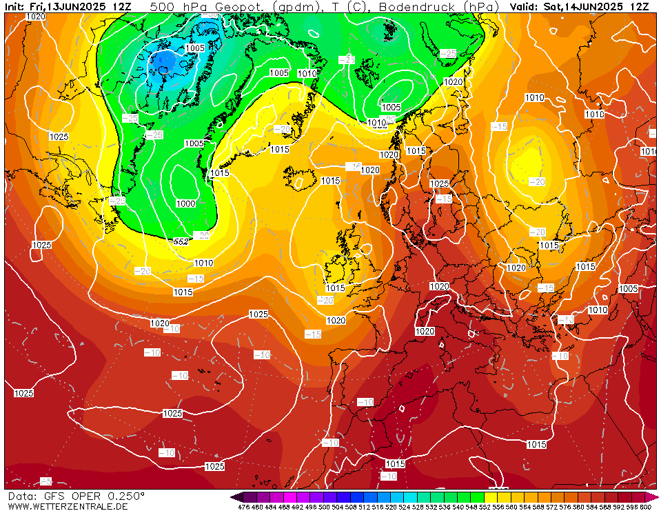
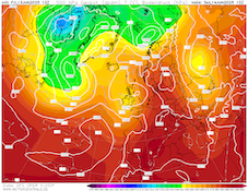
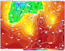
500 hPa geopotential and sea surface pressure
over Europe,
14.06 12 UTC
Source: wetterzentrale
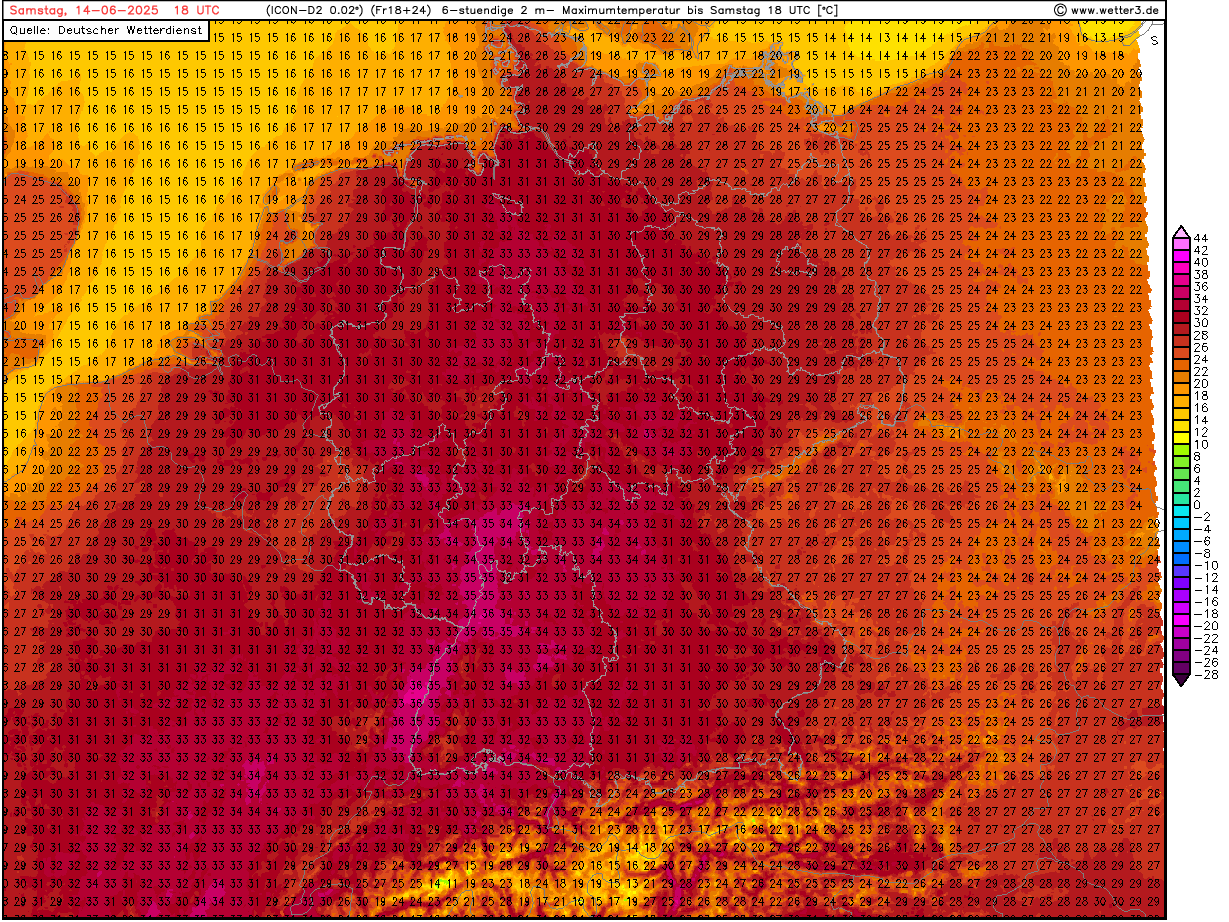
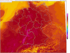
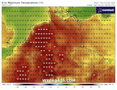
| 2 m maximum temperature over Germany,
14.06 18 UTC
Source: weetter3
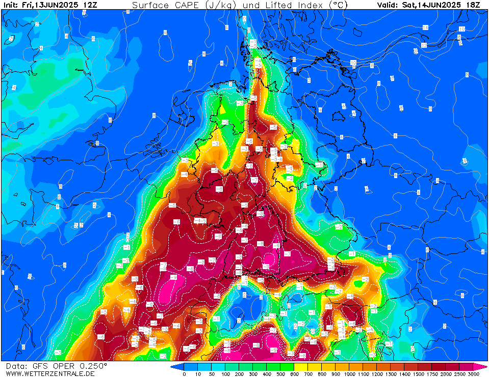
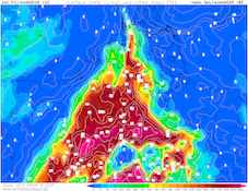
| Mixed-layer CAPE and Lifted Index values
over Central Europe,
14.06 18 UTC
Source: wetterzentrale
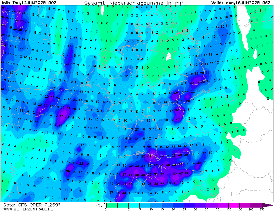
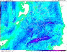
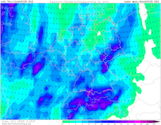
| Accumulated precipitation totals over Central Europe,
until 16.06 06 UTC
Source: wetterzentrale
|
Heat wave, thunderstorms
Western and Central Europe
Issued: Friday, June 13, 2025, 21:00 UTC
A potent early summer heat wave is continuing to impact much of Western and Central Europe. Tomorrow, June 14, 2025, the peak temperatures are forecasted to impact Central Europe with daytime maximum temperatures of up to 36 °C. An approaching trough over the British Isles is expected to induce convective activity across Europe.
13.06.2025
An Omega weather pattern is continuing to bring very warm air masses to Western and Central Europe. The two troughs are located near the British Isles west of the ridge and over Western Russia east of the ridge. With this synoptic pattern, 850 hPa temperatures reach more than 20 °C over Western and Central Europe. In the past few days, temperatures have already reached more than 35 °C in Western Europe.
Tomorrow, June 14, 2025, the trough over the British Isles is forecasted to move eastwards. Ahead of the trough, the very warm airmasses are expected to penetrate far northwards across Central Europe. As a result, most lower-elevation areas will reach daytime maximum temperatures of more than 30 °C. Along the Upper Rhine Valley, maximum temperatures of up to 36 °C are likely. Locally, higher maximum temperatures cannot be excluded. Overnight lows in metropolitan areas are forecasted to remain above the 20 °C mark. Additionally, dewpoints of up to 20 °C will lead to elevated heat stress levels.
Ahead of the cold front of the nearing trough, convective activity is forecasted to flare up on June 14, 2025. With copious diurnal insolation, large mixed-layer CAPE values are expected to build up over Western Germany. In the overnight hours to June 15, 2025, large-scale convective clusters are forecasted to move eastwards across Central Europe. Heavy downpours may occur. With daytime thunderstorms development, strong convective downdrafts are possible due to the formation of intense cold pools. On June 15, 2025, diurnal insolation will likely induce potent convective activity across Southern Germany, especially south of the Danube River. Behind the cold front, temperatures will likely remain at elevated levels compared to the climatological average for mid-June.
Thursday, June 12, 2025, 07:30 UTC
|
|
|
|
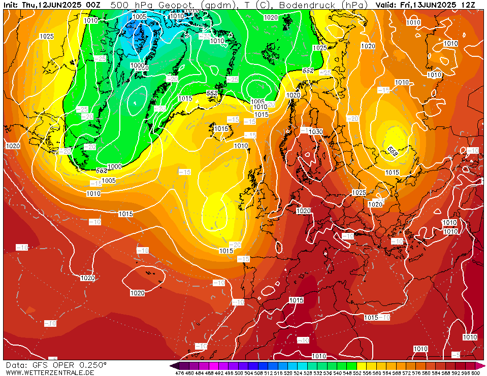
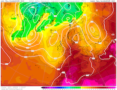
500 hPa geopotential and sea surface pressure
over Europe,
13.06 12 UTC
Source: wetterzentrale
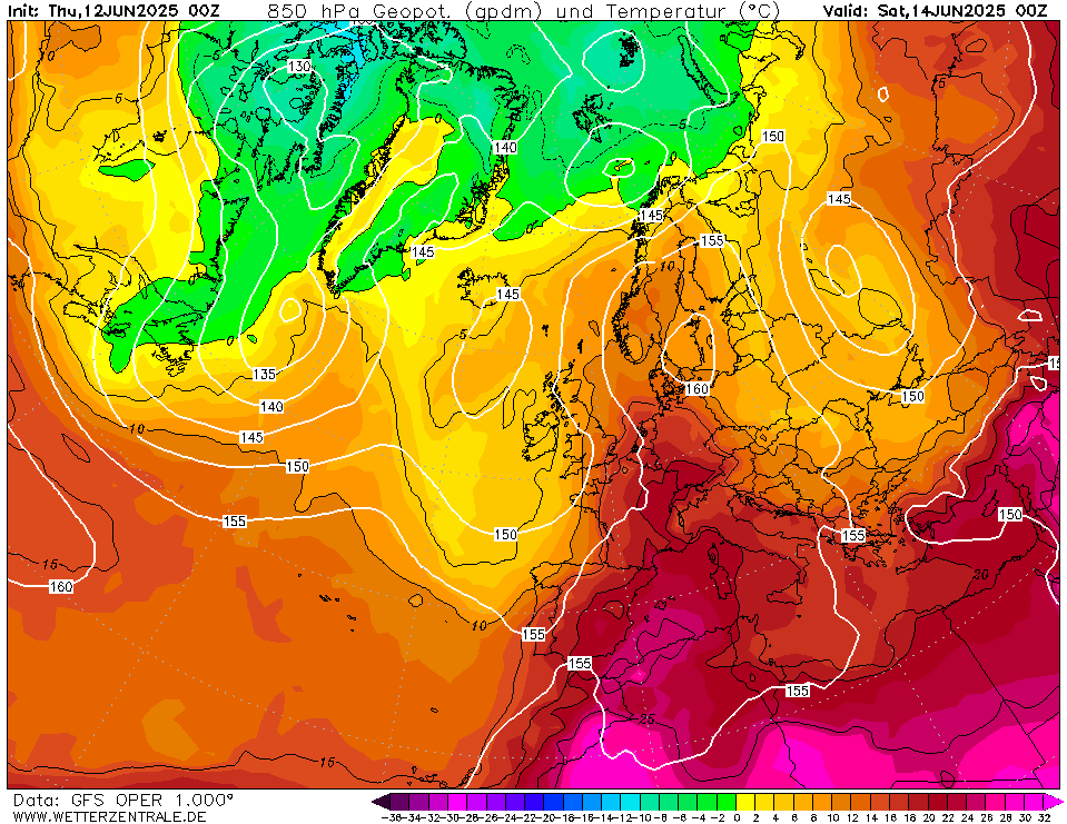
| 850 hPa temperature and geopotential over Europe,
14.06 00 UTC
Source: wetterzentrale
| 2 m maximum temperature over Central Europe,
14.06 18 UTC
Source: wxcharts
| Accumulated precipitation totals over Central Europe,
until 16.06 06 UTC
Source: wetterzentrale
|
Heat wave
Western and Central Europe
Issued: Thursday, June 12, 2025, 07:30 UTC
The first heatwave of the summer season of 2025 is forecasted to impact Western and Central Europe from Thursday, June 12 to Sunday, June 15, 2025. Over France, daytime maximum temperatures of more than 35 °C are forecasted. In Southern Germany, temperatures may also reach up to 35 °C. An approaching trough can induce severe weather both on June 14 and June 15, 2025.
12.06.2025
An omega-shaped weather pattern has developed over Europe in the past few days. A large ridge has expanded northwards across Central Europe. On either side of the ridge, two troughs are located over the Eastern North Atlantic and Eastern Europe. Due to this synoptic set-up, very warm air masses are advected into Central Europe. 850 hPa temperatures are forecasted to reach more than 20 °C for the first time this summer over Western and Central Europe.
Daytime maximum temperatures have already reached more than 35 °C over Southern France on June 11, 2025. Thursday, June 12, 2025, temperatures will once again reach more than 35 °C in parts of France. With the trough west of the ridge moving eastwards, the center of the heatwave is forecasted to shift eastwards into Central Europe. On Friday, June 13, 2025, daytime maximum temperatures will reach more than 30 °C for the first time this summer in large parts of Central Europe. On Saturday, June 14, 2025, the peak of the heat is expected across Central Europe. Maximum temperatures of more than 30 °C will be common. Along the Rhine River, maximum temperatures may approach 35 °C. Heat stress levels will be elevated due to high overnight low temperatures and high dewpoint temperatures of up to 20 °C on June 14, 2025.
The westerly trough is forecasted to induce convective activity as it nears Western Europe. Beginning on Friday, June 13, 2025, convection may develop over France. By June 14, 2025, convective activity is forecasted also in the western parts of Germany. On June 15, 2025, widespread convective activity is forecasted to impact much of Central Europe as colder air masses move eastwards. By June 16, 2025, temperatures are forecasted to decrease close to the seasonal average.
Friday, June 13, 2025, 21:00 UTC
KG
Thursday, June 12, 2025, 07:30 UTC
KG
|