Wednesday, June 04, 2025, 08:00 UTC
|
|
|
|
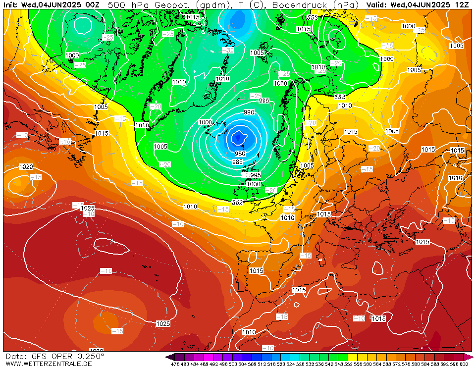
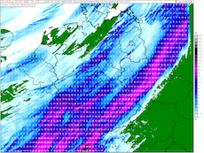
500 hPa geopotential and sea surface pressure
over Europe,
04.06 12 UTC
Source: wetterzentrale
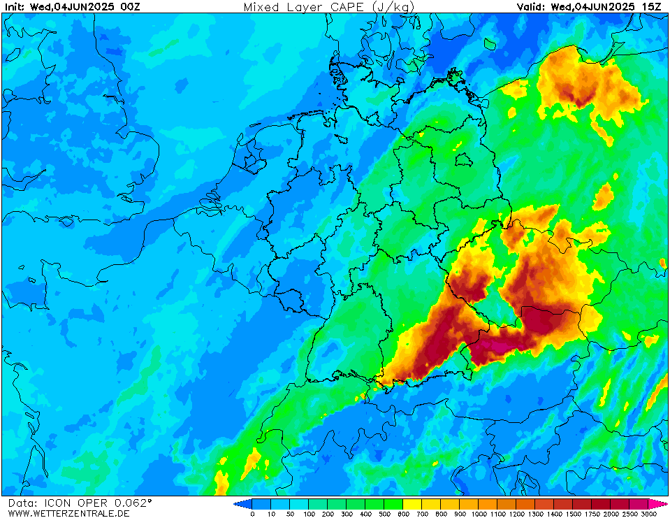
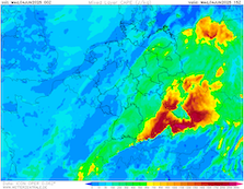
| Mixed-layer CAPE values over Central Europe,
04.06 15 UTC
Source: wetterzentrale
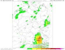
| Peak wind gusts over Germany,
04.06 18 UTC
Source: wetterzentrale
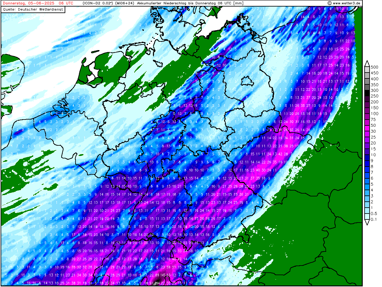
| Accumulated precipitation totals over Germany,
until 05.06 06 UTC
Source: wetter3
|
Severe thunderstorms
Southern Germany
Issued: Wednesday, June 04, 2025, 08:00 UTC
Severe thunderstorm activity is forecasted to impact the southern parts of Germany later today. Ahead of a cold front, synoptic conditions are forecasted to be very favorable for severe thunderstorms to develop with mixed-layer CAPE values of more than 2000 J/kg in the Danube Plain. Heavy downpours with precipitation rates of more than 30 mm/h, wind gusts of more than 100 kph, and large to very large hail are possible.
04.06.2025
Ahead of a large trough over the British Isles, warm and moist airmasses are advected into Central Europe. Over Northern Germany, a small low-pressure system has developed south of the main, unseasonably strong low-pressure system located north of the British Isles. The cold front of this small low-pressure system is expected to stall over Western Germany today, June 04, 2025. At times heavy precipitation is expected along a narrow strip near the cold front stretching from Dijon in France to the Frankfurt metropolitan area. Widespread precipitation totals of 15 to 30 mm are likely.
With diurnal insolation, significant mixed-layer CAPE values are forecasted to build up in the afternoon hours. Between the Northern Alps and the Danube River, mixed-layer CAPE values are expected to reach 1500 to 2000 J/kg. Current high-resolution NWP output suggests that convective activity will flare up over the Southern Black Forest and the Swabian Jura in the afternoon hours. After gradual organization, the convective cells are forecasted to move northeastwards. Upon reaching the Allgäu area in Southern Germany, different NWP solutions tend to diverge. The first solution tends to form new convective clusters by the cold pool outflow east of the decaying initial convective clusters. The second and more potent solution suggests that the initial convective activity forms a large mesoscale convective system (MCS) over the Danube Plain. This system strengthens further as it moves northeastwards across Southern Bavaria, fueled by the high mixed-layer CAPE values in the area.
Regardless of the exact development of the convective activity over Southern Germany, the potential for severe weather is given as large CAPE values and high shear values overlap. High atmospheric water contents of up to 35 mm give the potential for heavy downpours. Depending on the degree of convective organization, there is a potential for violent convective downdrafts of more than 120 kph. Additionally, there is a threat of large to very large hail with diameters of 5 cm if well-organized supercells with strong updrafts develop in the evening hours. The overlap of CAPE and shear in Southern Bavaria is forecasted to be unseasonable high close to the climatological maximum for early June. If this environment is realized, the resultant convective updrafts may even support the formation of hail stones with diameters of more than 5 cm.
In the nighttime hours, the convective activity is forecasted to spread northeastwards into Czechia. The severe weather risks will slowly decay throughout the night to June 05, 2025. In the nighttime hours, the main threat will be related to heavy downpours.
Wednesday, June 04, 2025, 08:00 UTC
KG
|