Wednesday, January 08, 2025, 08:00 UTC
|
|
|
|
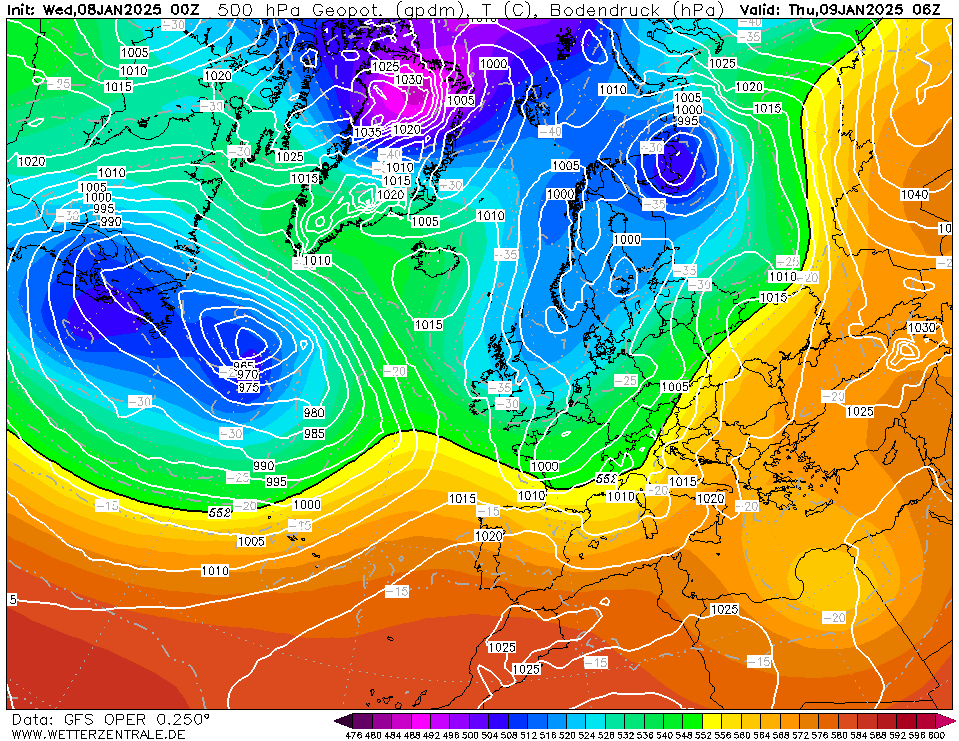
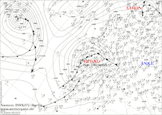
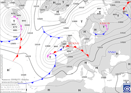
500 geopotential and mean sea level pressure
over Europe,
09.01 06 UTC
Source: wetterzentrale
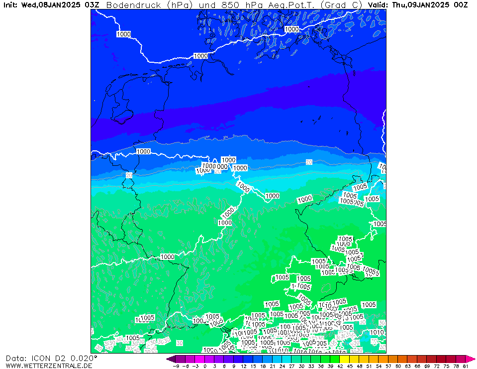
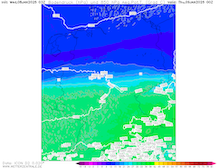
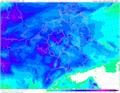
| 850 hPa pseudo-potential temperature
over Germany,
09.01 00 UTC
Source: wetterzentrale
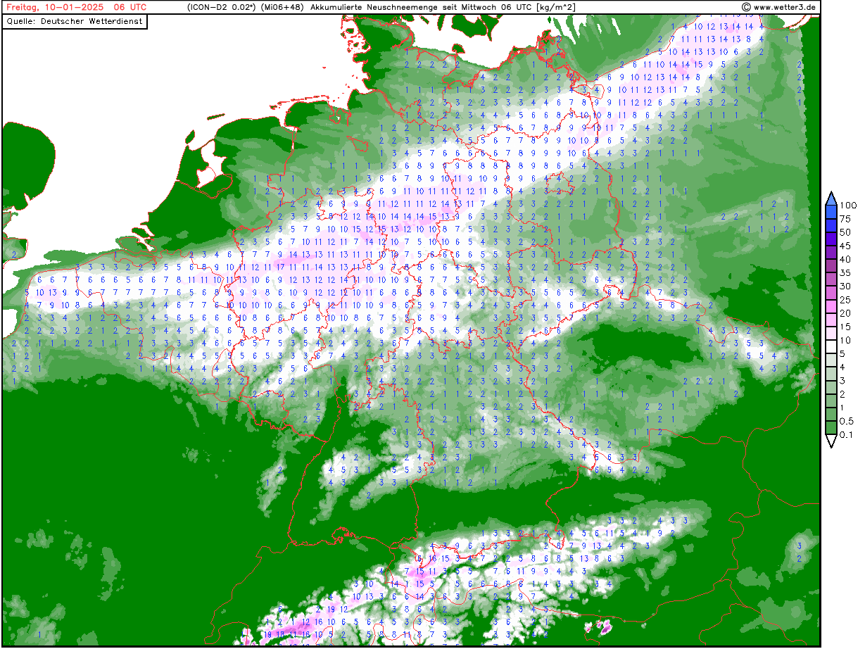
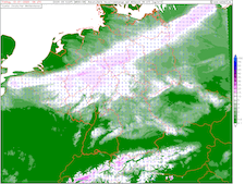
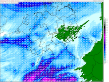
| Total fresh snow accumulation over Germany,
until 10.01 06 UTC
Source: wetter3
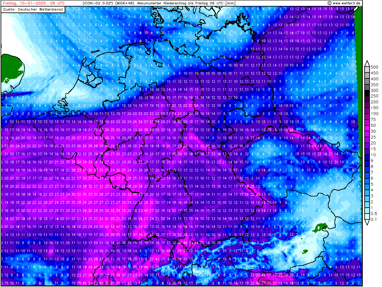
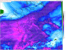
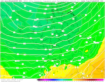
| Accumulated precipitation over Germany,
until 10.01 06 UTC
Source: wetter3
|
Heavy snow
Belgium, Central Germany
Issued: Wednesday, January 08, 2025, 08:00 UTC
An air mass boundary related to low Charly is expected to move across Central Europe. With the air mass boundary, at times heavy precipitation may occur. In a band stretching from Southern North Rhine-Westphalia to Berlin, fresh snow accumulations of 5 to 15 cm are possible.
08.01.2025
The turbulent weather across Central Europe prevails. In quick succession to low Bernd, low Charly is forecasted to move across Central Europe today, January 08, 2025, with its warm front. The warm front of the low will bring moderate precipitation as the subtropical air masses move northeastwards. Over the central part of Germany, it is expected that the warm front will stall, and a distinct air mass boundary will form. The 850 hPa pseudo-potential temperature forecast reveals a sharp pseudo-potential temperature gradient over Germany. Maritime polar air masses to the north will bounder to subtropical air masses in the south.
In the afternoon and evening hours of January 08, 2025, moderate to heavy snow may occur at times in the Rhineland-Palatine, North Rhine-Westphalia, and Hesse. At lower elevations, fresh snow accumulations of 5 cm are possible. At higher elevations, fresh snow accumulations of up to 10 cm are possible. With the intruding subtropical air masses, the precipitation will quickly turn into rain. Freezing rain may occur during the transition period at higher elevations. Currently, forecasts suggest that the surface boundary between snow and rain will be located somewhere in Southern North Rhine-Westphalia.
On Thursday, January 09, 2025, the cold front of low Charly will reach Germany. With the cold front, the snowline will drop significantly. In a band stretching from Southern North-Rhine Westphalia to Berlin, fresh snow accumulations between 5 to 10 cm are possible. In Southern North Rhine-Westphalia, the storm total fresh snow accumulation may reach more than 10 cm at lower elevations and more than 20 cm in the Sauerland mountains. Over Rhineland-Palatine, the cold front may bring up to 5 cm of fresh snow accumulation within a short time. Depending on the precipitation totals over Western Germany, minor river flooding may develop.
Over Southern Germany, the cold front of low Charly will bring heavy precipitation. Relative to the degree of organization of the cold front, high winds may occur over Southern Germany. Along the Danube Plain, wind gusts of up to 90 kph are possible if the cold front is highly organized.
Monday, January 06, 2025, 13:00 UTC
|

|
|
|
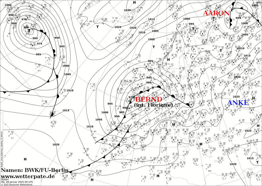
Mean sea level pressure and
analyzed fronts over Europe,
06.01 00 UTC
Source: FU Berlin
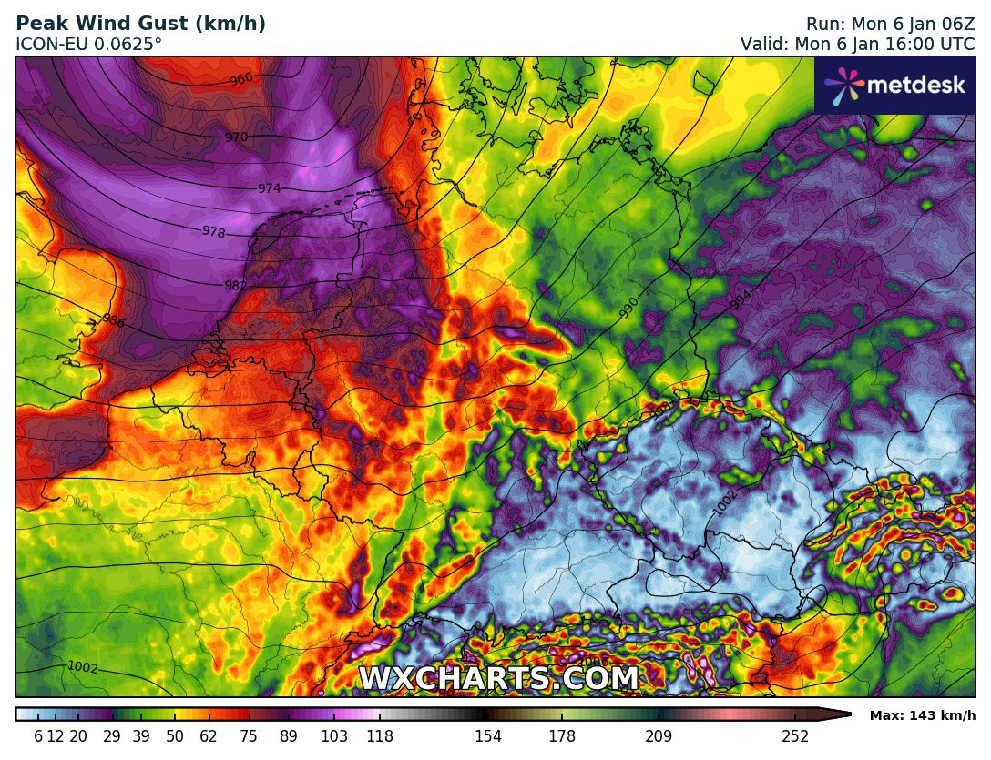
| Peak wind gusts and mean sea level pressure
over Germany,
06.01 16 UTC
Source: wxcharts
| Accumulated precipitation over Germany,
until 07.01 06 UTC
Source: wetter3
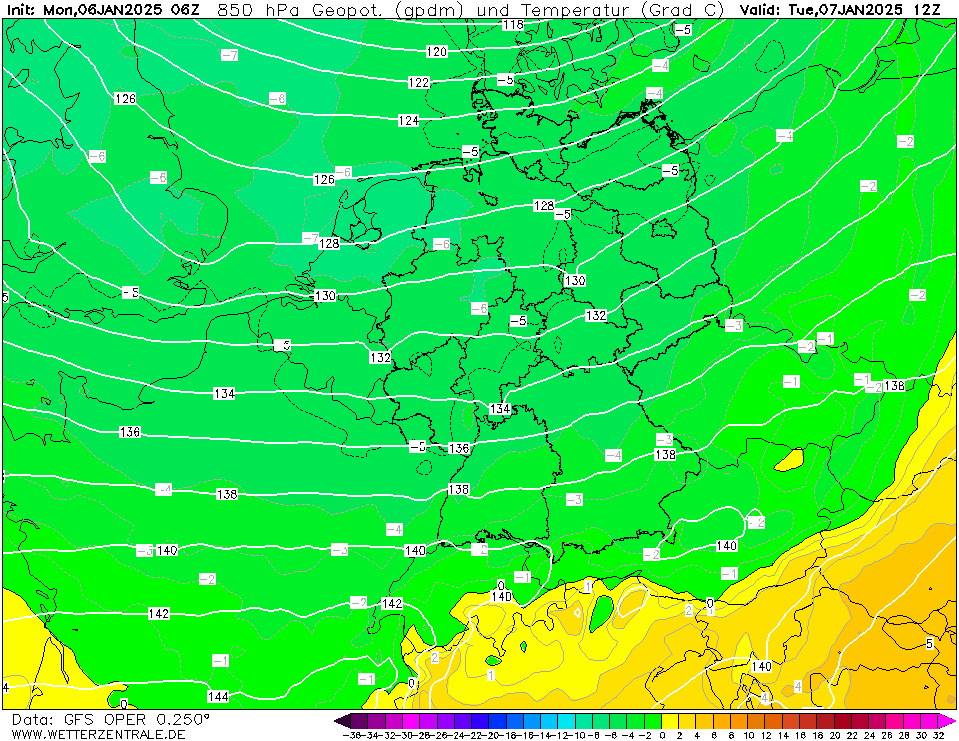
| 850 hPa temperature and geopotential
over Central Europe,
07.01 12 UTC
Source: wetterzentrale
|
Wind storm
Belgium, Netherlands, Northwestern Germany
Issued: Monday, January 06, 2025, 13:00 UTC
Southeast of low Bernd, the sharp pressure gradient of the low-pressure system is forecasted to induce high winds over Central Europe. At exposed locations or close to showers in Belgium, the Netherlands, and parts of Germany, wind gusts of more than 100 kph may occur.
06.01.2025
After low Bernd brought an icy mix of wintery weather with its warm front on Sunday, January 05, 2025, the core of the low-pressure system is currently moving across the North Sea. South of the elongated low-pressure system, a large pressure gradient is inducing high winds across Central Europe. In the past hours (12 UTC), widespread wind gusts of 90 to 100 kph have been observed over the Grand Est in France. Near Reims, a wind gust of 117 kph has been observed in the past hour.
In the coming hours, it is expected that the wind field of low Bernd shifts northeastwards into Belgium, the Netherlands, and the northwestern part of Germany. North of a line stretching from the Moselle River to the Harz Mountains, high winds with gusts of more than 80 kph must be expected. At higher elevations and exposed locations, wind gusts of more than 100 kph may occur. Even at lower elevations, triple-digit wind gusts may occur during the passage of showers in the Northern German Plains during the afternoon and evening hours. Atop the Brocken mountain in the Harz mountain range, hurricane-force winds with gusts of 150 kph can occur. Over the North Sea, hurricane-force winds are expected to transpire from the Skagerrak to the German coast.
Before midnight, the wind field of low Bernd is forecasted to move over the Baltic Sea. Early tomorrow, January 07, 2025, high winds with gusts of 80 kph may occur in Southern Sweden. Behind low Bernd, cold air masses are expected to be advected into Central Europe.
Saturday, January 04, 2025, 18:30 UTC
|
|
|
|
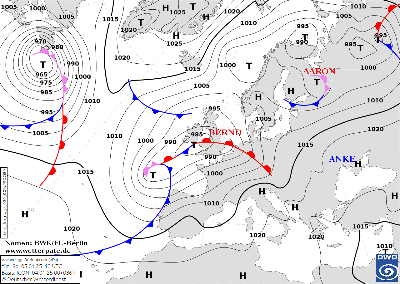
Forecasted mean sea level pressure and
fronts over Europe,
05.01 12 UTC
Source: FU Berlin
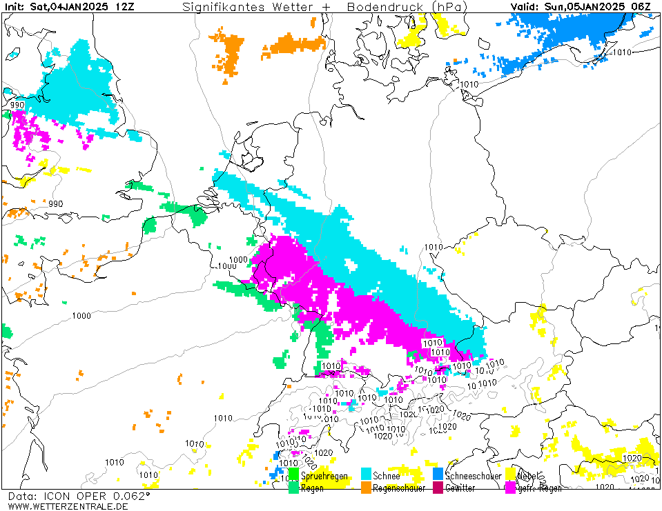
| Significant weather and mean sea level pressure
over Germany,
05.01 06 UTC
Source: wetterzentrale
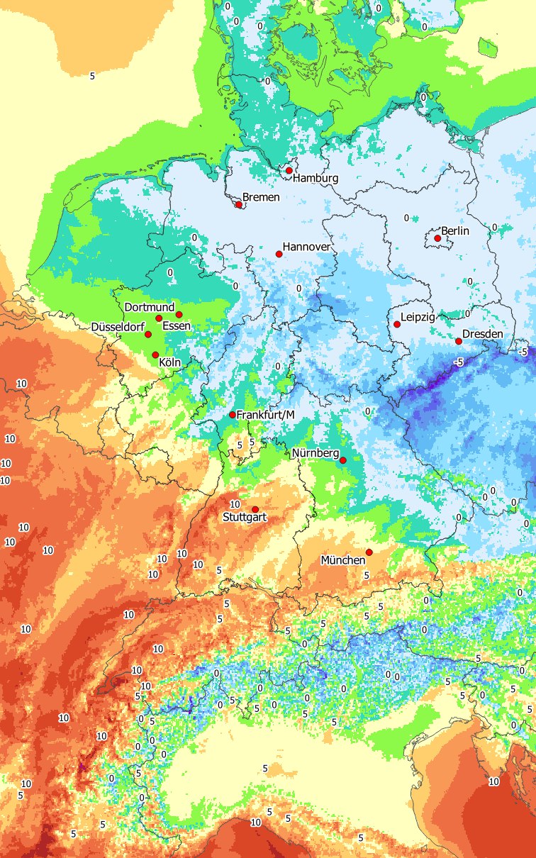
| 2 m temperature
over Germany,
05.01 12 UTC
Source: DWD,
visualization: B. Mühr
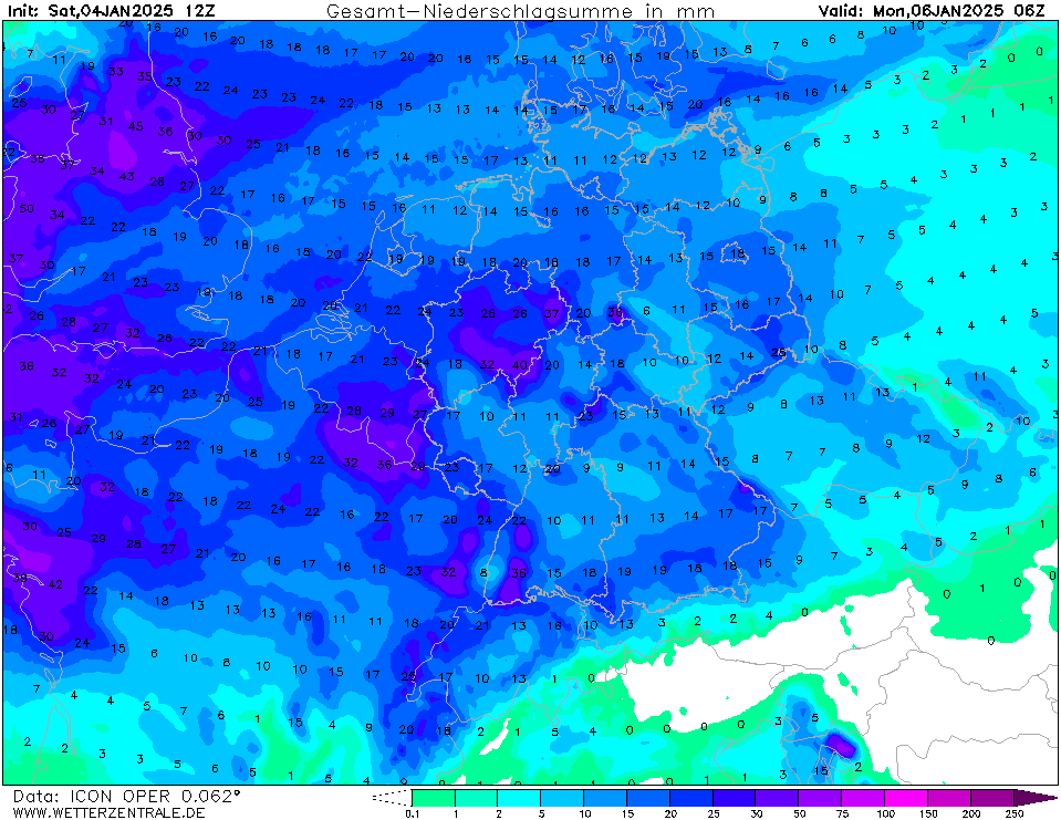
| Accumulated precipitation over Central Europe,
until 06.01 06 UTC
Source: wetterzentrale
|
Icing, snow
Germany
Issued: Saturday, January 04, 2025, 18:30 UTC
A potent warm front is expected to cross Germany on Sunday, January 05, 2025. With the warm front, an icy mix of wintery weather is forecasted to impact all of Germany throughout the day. Behind the front, very mild temperatures with temperatures of more than 12 °C are anticipated at lower elevations.
04.01.2025
A broad low-pressure system over the Eastern Atlantic is expected to reach Europe on Sunday, January 05, 2025. Low Bernd features a potent warm front. With the warm front, an icy mix of wintery weather is forecasted to pass over all of Germany, starting early on Sunday morning. Initially, moderate to heavy snow impacts the southwestern part of Germany. Within a few hours, multiple centimeters of fresh snow may accumulate even at lower elevations. At higher elevations, warm air masses with 850 hPa temperatures of more than 5 °C will be spreading eastwards.
As a result, the precipitation will quickly transform into rain. The transition will begin first at higher elevations because the warm air masses will penetrate these areas the quickest. Due to the prevalent frozen grounds and sub-zero temperatures, a period of freezing rain is expected to occur during the transition from snow to rain. As a result, dangerous road conditions are expected to spread northeastwards across Germany. In Southwestern Germany, the transition will occur around 06 UTC on January 05, 2025. At lower elevations or in narrow valleys, the period of freezing rain will be prolonged due to the collection of cold air. By 12 UTC, the area of freezing rain will reach Central Germany, and by 18 UTC, the freezing rain will reach Berlin.
During the passage of the warm front of low Bernd, treacherous traveling conditions are likely. Due to the rapid transition to very mild temperatures, the grounds will quickly thaw after the initial freezing rain decreasing the risk of prolonged icing. On Monday, January 06, 2025, mild temperatures with maxima of more than 12 °C are expected at lower elevations in Western Germany.
Wednesday, January 08, 2025, 08:00 UTC
KG
Monday, January 06, 2025, 13:00 UTC
KG
Saturday, January 04, 2025, 18:30 UTC
KG
|