Thursday, November 21, 2024, 08:00 UTC
|
|
|
|
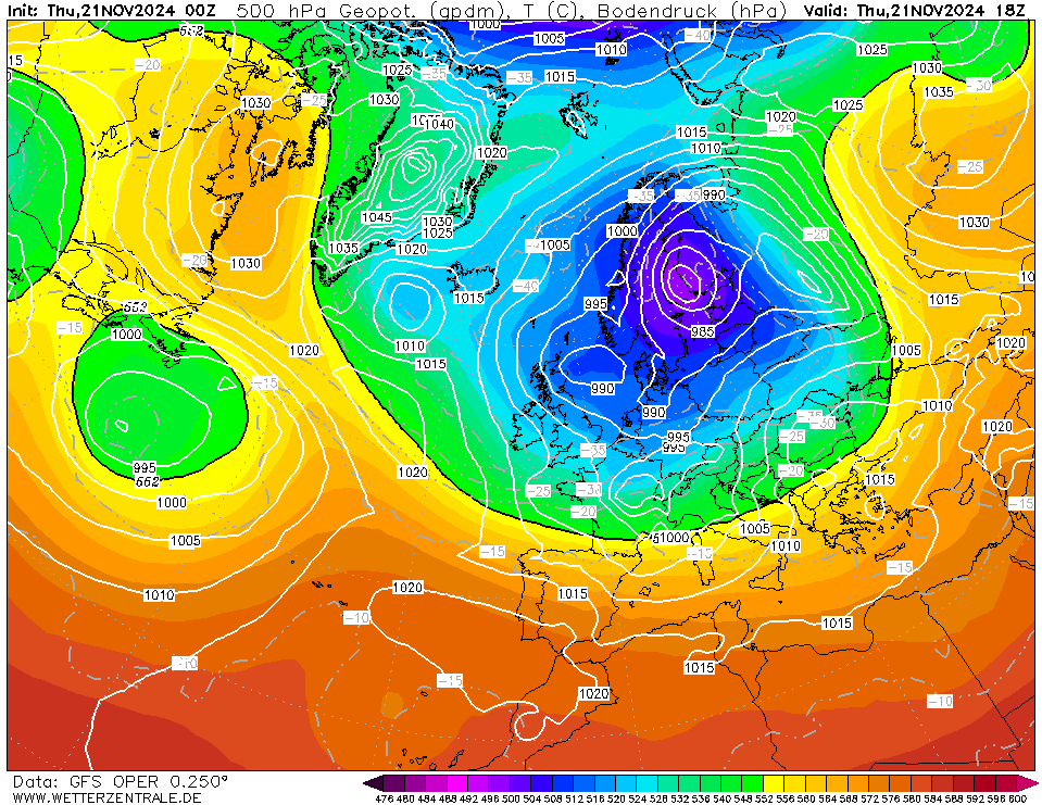
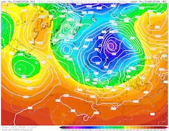
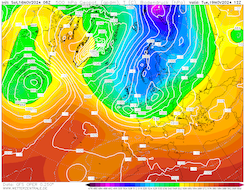
500 hPa geopotential and mean sea level pressure
over Europe
21.11 18 UTC
Source: wetterzentrale
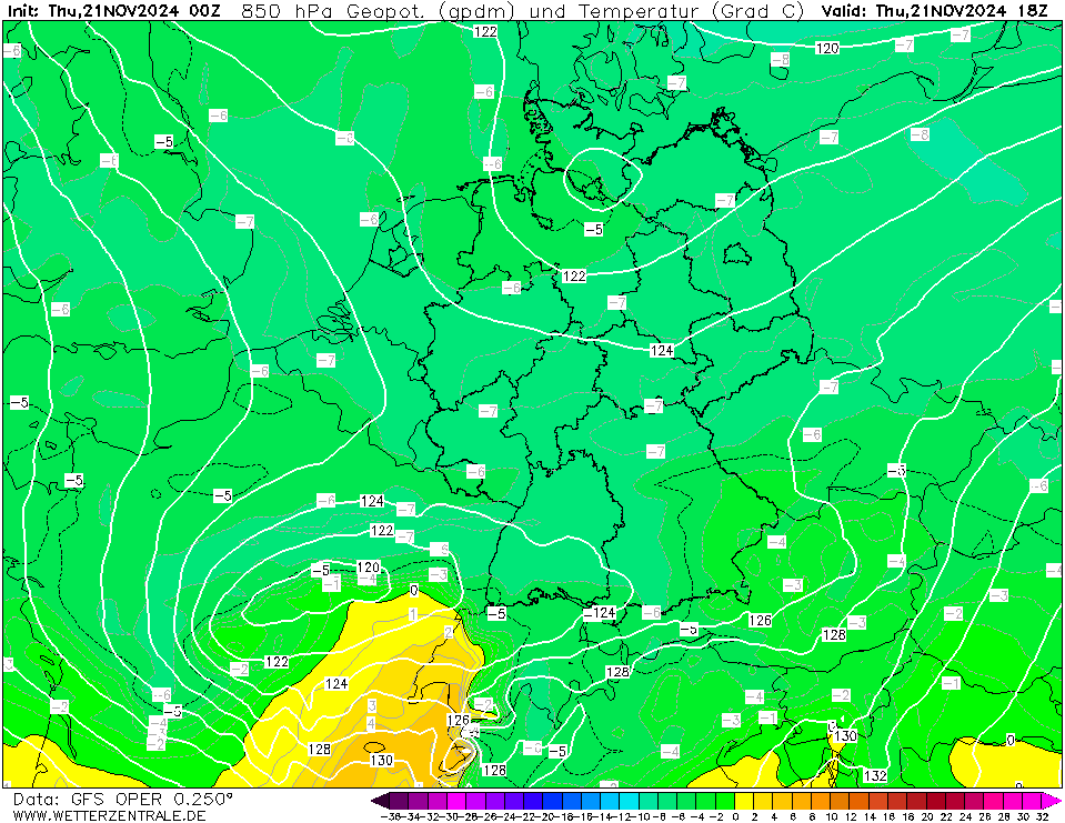
| 850 hPa temperature and geopotential
over Central Europe,
21.11 18 UTC
Source: wetterzentrale
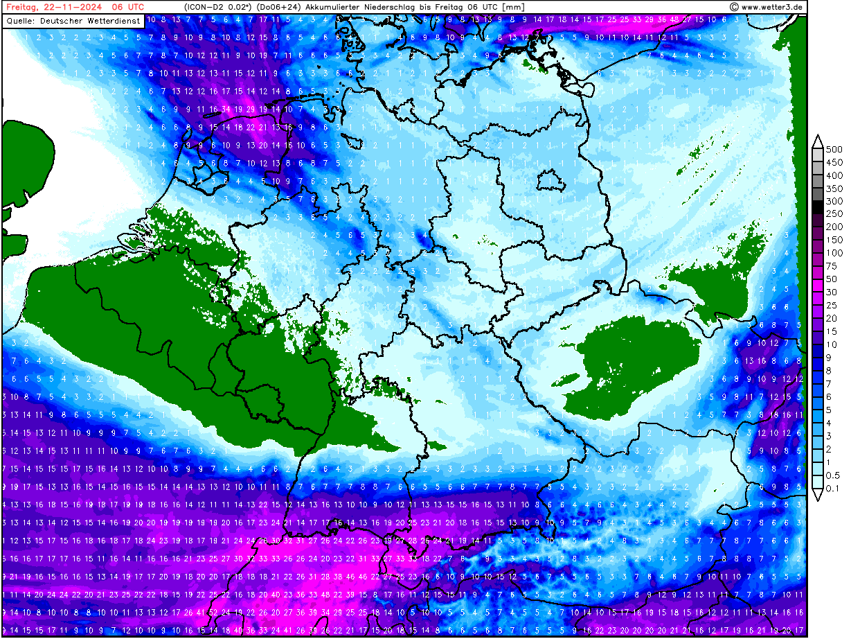
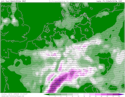
| Accumulated precipitation over Central Europe,
until 22.11 06 UTC
Source: wetter3
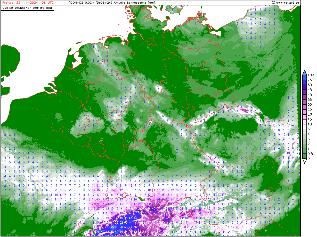
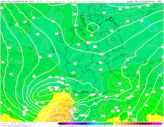
| Snow depth over Central Europe,
22.11 06 UTC
Source: wetter3
|
Heavy snowfall
Switzerland and Southernmost Germany
Issued: Thursday, November 21, 2024, 08:00 UTC
A small low-pressure system is expected to bring abundant snowfall to the southernmost part of Germany and the Alps. Tonight, November 21 to November 22, 2024, fresh snow accumulations of more than 10 cm are possible at lower elevations. In the Black Forest and the Northern Alps, fresh snow accumulations of more than 30 cm are possible.
21.11.2024
A strong trough over Scandinavia is continuing to dominate the weather pattern across Europe. With it, unseasonably cold air masses are advected into Central Europe. Over the Northern Atlantic, a small low-pressure system has developed along the polar front and is quickly approaching Europe. Due to the cold air mass residing over Central Europe, the warm front of said low is not able to clear the low-level cold air masses. As a result, most to all the precipitation related to the low-pressure system is expected to precipitate as snow.
In a stretch from the Bretagne over Paris to the Alps, heavy snowfall is expected today, November 21, 2024. Fresh snow accumulations of 10 cm even at low elevations are possible. In Switzerland and the southernmost part of Germany, particularly heavy snowfall must be expected in the latter half of today and stretching into tomorrow, November 22, 2024. At high elevations in the Western Alps, fresh snow accumulations of more than 50 cm/24 h are possible. Between Zürich and Freiburg, lower elevations must expect unusually large snow accumulations. Within a few hours, fresh snow accumulations of 10 - 20 cm are possible. In the Black Forest and Swabian Jura, fresh snow accumulations of more than 30 cm are possible. Due to the expected heavy snow, significant traffic disruptions are likely to occur in the evening hours.
Saturday, November 16, 2024, 15:30 UTC
|
|
|
|
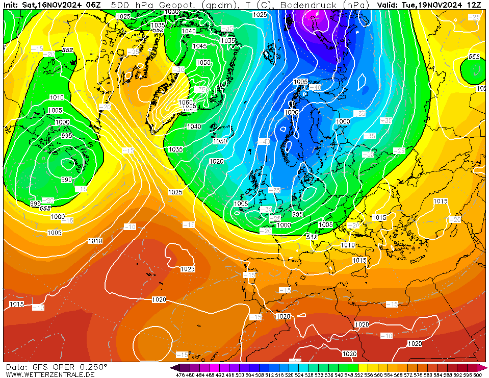
500 hPa geopotential and mean sea level pressure
over Europe
19.11 12 UTC
Source: wetterzentrale
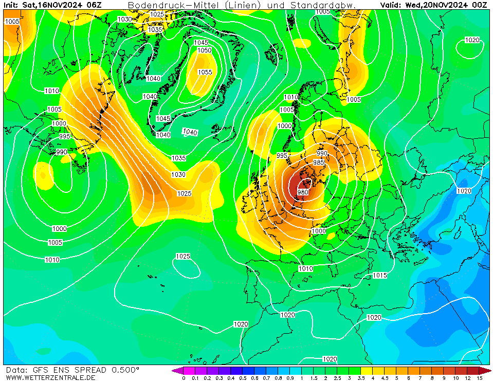
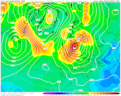
| Ensemble-mean and ensemble standard deviation
of the mean sea level pressure over the Europe,
20.11 00 UTC
Source: wetterzentrale
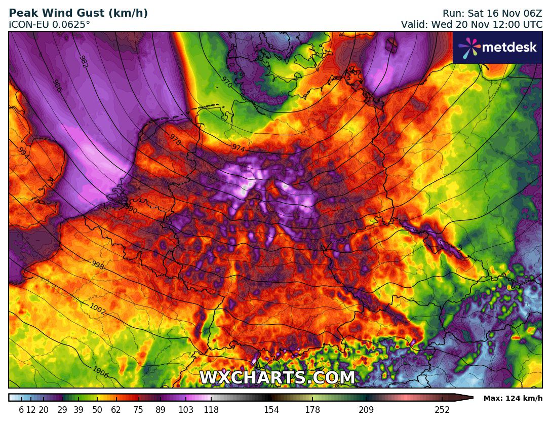
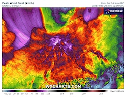
| Peak wind gusts over Germany in case of
a very strong secondary cyclogenesis
20.11 12 UTC
Source: wxcharts
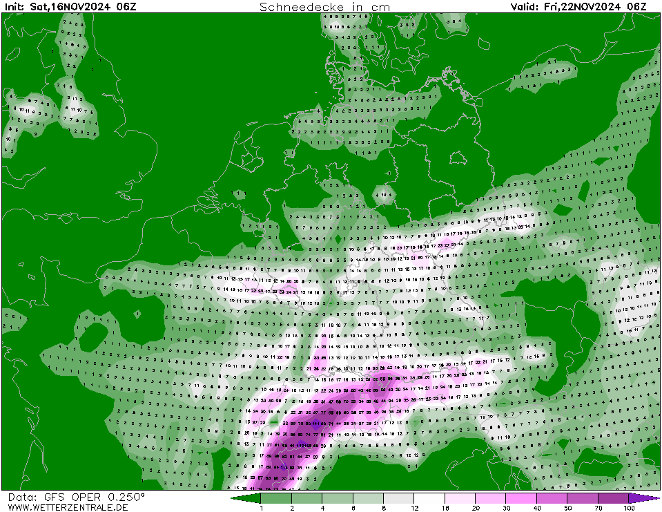
| Snow depth over Central Europe,
22.11 06 UTC
Source: wetterzentrale
|
Wind storm
Central Europe
Issued: Saturday, November 16, 2024, 15:30 UTC
A large trough is forecasted to dominate the weather over Europe following a major weather pattern change. With the trough, below-average temperatures are expected to spread across Central Europe. On Tuesday, November 19, 2024, a secondary cyclogenesis is anticipated to bring a potentially very strong winter storm to Central Europe with wind gusts of more than 100 kph.
16.11.2024
The last 4 weeks were dominated by large high-pressure systems residing over Europe. Subsequently, the low-pressure systems were deviated far northwards into the Arctic. Currently, a large low-pressure system is moving across Scandinavia. Behind the low, cold air masses of Arctic origin are forecasted to move far southwards. Meeting warm airmasses of subtropical origin over the Northern Atlantic, secondary cyclogenesis is expected to occur over the British Isles on Monday, November 18, 2024. Said low is expected to move quickly across Central Europe on Tuesday, November 19, 2024.
Currently, the strength of the secondary cyclogenesis is very uncertain. Depending on the NWP output, a potentially very strong windstorm is forecasted to impact the Netherlands and Northern Germany on November 19, 2024 and November 20, 2024. The ensemble standard deviation for the mean sea level pressure over the North Sea on November 19 and November 20, 2024, is more than 12 hPa, highlighting a very dynamic and uncertain synoptic situation. Depending on the exact strength of the low, a potent windstorm may develop. Coastal areas as well as exposed regions in the mountain ranges of Northern Germany may experience wind gusts of more than 120 kph. Inland, wind gusts of 100 kph are possible. However, both the strength and track of the low are still uncertain.
Behind said low, unseasonably cold air masses are expected to penetrate Central Europe. With 850 hPa temperatures below -7 °C, even low-level areas may see their first snow of the 2024/25 winter season. At elevations above 500 m, the first significant fresh snow accumulations of the winter may occur in the latter half of the week.
Thursday, November 21, 2024, 08:00 UTC
KG
Saturday, November 16, 2024, 15:30 UTC
KG
|