Tuesday, September 17, 2024, 10:30 UTC
|
|
|
|
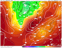
500 hPa geopotential
and sea-surface pressure over Europe,
17.09 12 UTC
Source: wetterzentrale
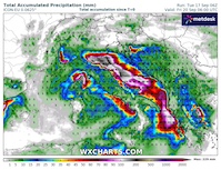
| Accumulated precipitation over Italy,
until 20.09 06 UTC
Source: wxcharts
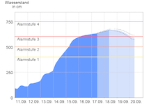
| River level forecast for the Elbe River
at Schöna, SN
17.09 09:30 UTC
Source: Landeshochwasserzentrum Sachsen
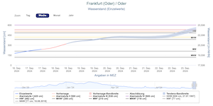
| River level forecast for the Oder River at Frankfurt (Oder), BB
17.09 09:00 UTC
Source: Pegelportal Brandenburg
|
Heavy precipitation, river flooding
Austria, Czechia, Poland, Italy
Issued: Tuesday, September 17, 2024, 10:30 UTC
After extreme precipitation related to low Anett, severe to catastrophic river flooding is spreading downstream along major rivers draining the affected areas. Along the Danube, Oder, and Elbe River a major river flood is occurring. Over Italy, heavy rains related to low Anett are expected up to 250 mm of rain in the next three days.
17.09.2024
In the past 7 days, low Anett brought extreme precipitation to large parts of Eastern Central Europe. In Lower Austria, 7-day precipitation totals surpassed the 400 mm-mark. As a result, severe river flooding is occurring in Austria, Czechia, and Poland. After the precipitation event subsided, the river levels along minor rivers are slowly decreasing. The river flooding is shifting into the major rivers draining the affected area. In Lower Austria, the Danube River is running close to the 100-year flood mark. In the area between Sankt Pölten and Vienna, some minor rivers surpassed the previous records by a large margin. The Perschling at Böheimkirchen reached at its peak a discharge of 270 m³/s. As a reference, a 100-year flood has a discharge of only 108 m³/s at this measuring gauge.
Currently, the highest river levels have already passed Vienna along the Danube River and are pushing into Hungary. In Czechia, the Elbe River has developed a severe river flood. By tomorrow, September 18, 2024, the highest water levels will reach the German-Czech border in the Ore Mountains. With an expected discharge of around 1700 m³/s at Schöna, SN, the river flood along the Elbe River is much lower than during the extreme flooding events in 2002 and 2013. These events had a peak discharge of 4570 m³/s and 3710 m³/s respectively. In Poland, the Oder River is also flooding severely. In the coming days, this river flood will also spread downstream. The highest water levels at the German-Polish border are only expected after September 23, 2024. Though currently, the seems likely that the water levels will remain below the extreme flooding event in 1997.
After the cut-off low related to low Anett will slowly in a westward direction, and much warmer air masses will reach Central Europe. As a result, substantial melting of the snowpack in the Alps must be expected in the coming week. Therefore, a secondary river flooding event may occur in some Alpine Valleys. Especially, the Alpine Valleys draining the Tauern Mountains should monitor the situation closely, as most of the precipitation here fell in the form of snow.
Though the worst rains of low Anett have subsided, heavy precipitation is expected in the Emilia-Romagna region in Italy in the next three days. In the area between Forlì and Bologna, widespread precipitation totals of more than 100 mm are possible. Locally, precipitation totals of more than 250 mm must be expected. Flash and river flooding is possible in the affected area.
Saturday, September 14, 2024, 10:00 UTC
|
|
|
|
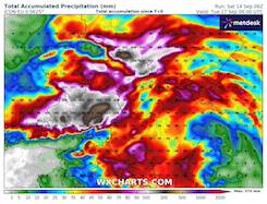
Accumulated precipitation over
Eastern Central Europe,
until 17.09 06 UTC
Source: wxcharts
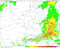
| Peak wind gusts over Central Europe,
15.09 03 UTC
Source: wetterzentrale
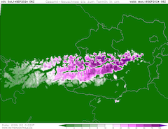
| Total snow accumulation in the Alps,
until 17.09 06 UTC
Source: wetterzentrale
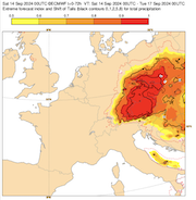
| EFI and shift of Tails index over
Central Europe for the 3-day precipitation,
14.09 00 UTC - 17.09 00 UTC
Source: ECMWF
|
Heavy precipitation, river flooding
Austria, Czechia, Poland
Issued: Saturday, September 14, 2024, 10:00 UTC
In the coming 24 h to 36 h, the highest precipitation totals of low Anett are expected. In the Sudetes and Lower Austria, 24 h precipitation totals will exceed 150 mm. Severe to catastrophic river flooding in the affected areas must be expected.
14.09.2024
In the past 24 h, heavy precipitation related to low Anett has been observed along northward-facing flanks in Eastern Germany, Poland, Czechia, and Austria. Widespread precipitation totals of more than 50 mm have been recorded. In areas with enhanced orographic lift, accumulations of more than 130 mm/24 h have been measured. At higher elevations in the Alps, fresh snow accumulation of more than 50 cm/24 h have been observed. Due to the torrential rains, many minor rivers draining the Sudetes, the Bohemian Forest, and the Northern Alps have rapidly risen.
In the coming 24 h to 36 h, the worst rains related to low Anett are expected to impact Czechia and Austria. Widespread precipitation totals of more than 100 mm/24 h must be expected. Along northward-facing flanks, precipitation totals of more than 150 mm/24 h are forecasted. The worst precipitation totals are expected along the Northern Alps in Lower Austria and the High Ash Mountains, where in the coming 48 h more than 300 mm can accumulate.
At higher elevations in the Alps, significant fresh snow accumulations are likely to occur above 1500 m. In the Eastern Alps, fresh snow accumulations of more than 100 cm are possible.
Due to the torrential rains, to risk of severe to catastrophic river flooding in large parts of Czechia, Poland, and Austria is expected to increase in the coming 48 h. Both in Lower Austria and along the Sudetes, the worst river flooding is expected. In combination with soft and saturated soils and wind speeds in Czechia of more than 80 kph widespread uprooting of trees is possible. Over the weekend, a major river flood is likely to develop along the Elbe, Danube, and Oder Rivers as well as its feeders.
Friday, September 13, 2024, 09:00 UTC
|
|
|
|
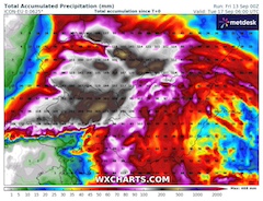
Accumulated precipitation over
Eastern Central Europe,
until 17.09 06 UTC
Source: wxcharts
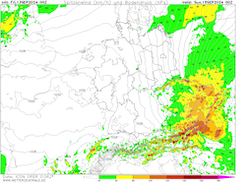
| Peak wind gusts over Central Europe,
15.09 00 UTC
Source: wetterzentrale
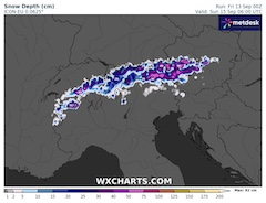
| Snow depth in the Alps,
15.09 06 UTC
Source: wxcharts
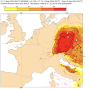
| EFI and shift of Tails index over
Central Europe for the 5-day precipitation,
13.09 00 UTC - 18.09 00 UTC
Source: ECMWF
|
Heavy precipitation, river flooding
Austria, Czechia, Poland
Issued: Friday, September 13, 2024, 09:00 UTC
The threat of extreme precipitation in Austria and Czechia related to Vb-low Anett continues. 5-day precipitation totals of more than 300 mm are possible. Severe river flooding is very likely. At elevations over 1000 m, significant fresh snow accumulations must be expected.
13.09.2024
Yesterday, September 12, 2024, the first precipitation related to low Anett fell across large parts of the eastern Alps stretching into Czechia. Widespread daily precipitation reached more than 40 mm. In Slovenia, daily precipitation of more than 100 mm were observed. At higher elevations in the Alps, significant fresh snow accumulations were recorded, with the snowline dropping to below 1000 m. Above 2000 m, fresh snow accumulation of up to 50 cm/24 h have already been measured.
Today, September 13, 2024, the main precipitation event will commence. In the coming 72 h, widespread precipitation totals of more than 200 mm are likely. In the last NWP models, a shift to the southeast of the highest precipitation totals related to low Anett has been indicated. Due to said shift, an increase in precipitation is forecasted for the Eastern Alps in Austria. In the region between Salzburg and Vienna, extreme precipitation with accumulations of more than 300 mm must be expected. Along northeastwards facing flanks, precipitation totals of more than 400 mm/5 d cannot be excluded.
Due to the cold air mass residing over Central Europe, significant fresh snow accumulations in the Northern Alps must be expected. Today, September 13, 2024, and tomorrow, September 14, 2024, the snowline in the Eastern Alps will remain at 1000 m. Some Alpine valleys may see significant fresh snow accumulation well below 1000 m due to precipitation cooling effects. Above 1500 m, fresh snow accumulations of 100 cm are likely. The Eastern Alps in Austria must expect fresh snow accumulations of more than 200 cm. Especially, the Dachstein and Tauern Mountains will see extreme fresh snow accumulations. Below the tree line due to foliage, significant snow breakage is likely. Above the tree line, a severe avalanche will mature due to the abundant fresh snow accumulation.
Along the Sudetes, the maximum precipitation has shifted eastwards along the mountain range. While the further west in the Giant Mountains, current NWP models show precipitation totals of up to 200 mm, a distinct decrease to yesterday's forecast. A distinct maximum of precipitation totals of up to 400 mm has matured in the High Ash Mountains further east. In the lee of the Sudetes, significantly less precipitation is expected. Over the central part of Czechia, widespread precipitation totals of more than 150 mm are forecasted. Along northeastwards facing flanks, precipitation totals could reach 250 mm.
The exacerbating pressure gradient between low Anett over Eastern Europe and high-pressure system Reinhold moving into Germany will lead to a significant threat of high winds across Czechia. The wind speeds across Czechia are forecasted to increase on Saturday, September 14, 2024, with the highest gusts being expected on Sunday, September 15, 2024. Lower elevations areas could see wind gusts of 80 kph. Along the mountain ranges bordering the Bohemian Massif, wind gusts of 100 kph are forecasted. At the highest peaks of the Sudetes, wind gusts of more than 120 kph must be expected. The combination of soft and saturated soils and high wind speeds will lead to a substantial threat of widespread tree uprooting.
In the entire area, which is impacted by the torrential rains of low Anett, large mud- and rockslides are possible. However, the main threat of this event will be severe river flooding. With the extreme precipitation totals forecasted in the High Ash Mountains, extreme surface run-off is forecasted to drain into the upper part of the Oder River. In Czechia, river flooding along the Elbe River and its feeders must be expected. The highest run-off will drain into the Danube River with its feeders draining the Bohemian Forest and the Eastern Alps.
The exact severity of the river flooding in Austria is still very hard to predict due to the uncertainty of the snow-to-liquid precipitation ratio in the Alps. Nevertheless, lower elevation valleys north of the Alps in Austria have a very high threat of severe flooding due to the extreme surface run-off. Currently, the highest lower elevations precipitation totals are forecasted in the vicinity of the city of Sankt Pölten. Major flooding must be expected. Downstream of the precipitation centers, major river flooding may develop in the coming week.
Thursday, September 12, 2024, 09:00 UTC
|
|
|
|
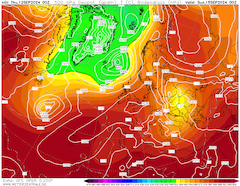
500 hPa geopotential and sea-surface pressure
over Europe,
15.09 00 UTC
Source: wetterzentrale
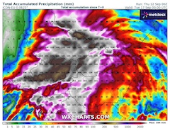
| Accumulated precipitation over Eastern Central Europe,
until 17.09 00 UTC
Source: wxcharts
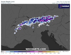
| Snow depth in the Alps,
15.09 06 UTC
Source: wxcharts
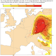
| EFI and shift of Tails index over
Central Europe for the 5-day precipitation,
13.09 00 UTC - 18.09 00 UTC
Source: ECMWF
|
Heavy precipitation, river flooding
Austria, Czechia, Poland
Issued: Thursday, September 12, 2024, 09:00 UTC
A Vb low-pressure system is expected to bring extreme precipitation to large parts of Central Europe. 5-day precipitation totals of more than 400 mm are possible along northeastwards-facing flanks of mountain ranges in the eastern part of Central Europe. Above 1500 m, significant fresh accumulations are forecasted. Severe river flooding must be expected.
12.09.2024
Contrary to the initial forecast from Monday, the track of the Vb-low Anett has shifted eastwards into Czechia and Poland. The associated cut-off low over Northern Italy will move slowly across the Alps from Friday, September 13, 2024, to Sunday, September 15, 2024. Concurrently, a large ridge from Western Russia will expand westwards into Central Europe. By Monday, September 16, 2024, a large ridge will be spanning north of the cut-off low across the British Isles over Scandinavia into Western Russia. The cut-off low will slowly move westwards south of said ridge pattern into early next week.
Due to the changes in the track of low Anett, the highest precipitation totals have also shifted eastwards into Czechia and Poland. Current NWP forecasts suggest that the highest precipitation totals are expected along the northeastwards-facing flanks of the Sudetes. Within the Sudetes, the highest precipitation totals are expected in the Giant Mountains and Opaswakie Mountains. The combination of orographic lift and embedded shower straights allows for precipitation of 400 mm/5 d. Locally, higher precipitation cannot be excluded. Severe river flooding in the region must be expected.
Both on Saturday, September 14, 2024, and Sunday, September 15, 2024, the pressure gradient at the eastern flank of low Anett will be exacerbated as the high-pressure system Reinhold will move eastwards into Central Europe. Along the Sudetes, wind gusts of more than 80 kph are possible. Along the highest mountains of the Sudetes, wind gusts of more than 120 kph are likely. In combination with the soft and saturated soils, widespread tree uprooting is possible.
For much of the Bohemian Massif, 5-day precipitation totals of more than 200 mm must be expected. The highest precipitation totals will likely be in the central part of Czechia. In the southwestern part of Czechia, the precipitation totals will once again increase as the Bohemian Forest induces orographic lift. The northeastern-facing flanks of Bohemian Forest may see 5-day precipitation of more than 300 mm. With a sinking snowline on Friday, September 13, 2024, and Saturday, September 14, 2024, the first snow of the 2024/25 winter season may accumulate at the highest peaks of the Bohemian Forest.
Along the Eastern Alps in Austria, heavy precipitation is expected to bring 5-day precipitation totals of up to 300 mm. Along the Dachstein and Tauern Mountains, 5-day precipitation totals of up to 400 mm are possible. Due to a sinking snowline, much of the precipitation above 1500 m will fall in the form of snow. Fresh snow accumulations of more than 100 cm are possible. Above 2000 m, fresh snow accumulations of more than 200 cm may occur. Above the tree line, a significant threat for avalanches will mature. At lower elevations due to the foliage, widespread snow breakage is possible.
In the entire area that will be affected by the heavy precipitation of low Anett, severe river flooding is more than likely. Especially the rivers draining the Sudetes will see rapidly rising water levels. Major rivers such as the Elbe River, the Danube River, the Vltava River, and the Oder River may see severe flooding later this week and next week. Mud- and rockslides due to the soft and saturated soils must be expected.
The severity of the river flooding is currently still uncertain and will depend on the exact focal point of this event. Nevertheless, the potential for a catastrophic river flood is given and therefore the situation should be monitored closely.
Monday, September 09, 2024, 08:30 UTC
|
|
|
|
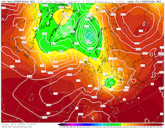
500 hPa geopotential and sea-surface pressure
over Europe,
13.09 06 UTC
Source: wetterzentrale
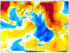
| 850 hPa temperature deviation over Europe,
13.09 18 UTC
Source: wetterzentrale
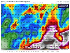
| Accumulated precipitation over Germany,
until 16.09 06 UTC
Source: wxcharts
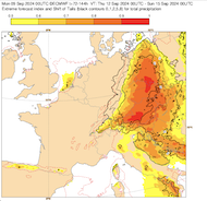
| EFI and shift of Tails index over
Central Europe for the 3-day precipitation,
12.09 00 UTC - 15.09 00 UTC
Source: ECMWF
|
Heavy precipitation, snow
Europe
Issued: Monday, September 09, 2024, 08:30 UTC
A strong cut-off low is expected to bring abundant precipitation to large parts of Central Europe. 7-day precipitation totals of more than 250 mm/24 h along northward-facing flanks in the Alps are likely. At elevations above 2000 m, significant fresh snow accumulations of more than 100 cm are possible.
09.09.2024
After a strong ridge brought well-above-average temperatures for most of the second half of August 2024 and the first week of September, a major weather pattern change is occurring currently over Europe. With a strong trough over Scandinavia, well-below-average temperatures are advected into Europe by September 10, 2024. In Central and Southern Europe, 850 hPa temperature deviations of more than -10 K are possible. North of the Alps the 850 hPa temperature may reach the freezing mark for the first time after the summer.
By September 11, 2024, the trough over Scandinavia will have established itself over Europe. By late September 12, 2024, or early September 13, 2024, a cut-off low will develop at the southern tip of the trough over Northern Italy. Model consensus is that said cut-off low will develop a classic Vb low structure at the surface level. A surface low is expected to move slowly northeastwards across Central Europe later this week.
This weather pattern is known for bringing abundant precipitation to Central Europe. The low- and mid-level circulation around the low-pressure system advects very warm and moist air masses from the Mediterranean around the low-pressure center and into Central Europe. Due to abnormally high water temperatures of the Mediterranean with sea surface temperatures of more than 28 °C, the moisture transport into Central Europe is likely enhanced.
Current, NWP output suggests that in the period from September 12 to September 14, 2024, continuous heavy precipitation is likely to impact the Northern Alps. 7-day precipitation totals of more than 300 mm are possible. The exact location of the focal point of this event remains highly variable in current NWP output. But it will likely impact Southeastern Bavaria and Austria. Further, areas in the Ore Mountains, the Bavarian Forest, and the Giant Mountains could receive upwards of 200 mm of rain.
Due to residing arctic air mass over Central Europe, abundant higher elevation snow accumulation is likely in the Alps. Above 2000 m, fresh snow accumulations of more than 100 cm are possible, especially along the main chain of the Alps in Austria. With 850 hPa temperatures dropping to the freezing mark on September 13, 2024, the snow line will drop below 1500 m. In combination with precipitation cooling effects, some Alpine valleys in the Northern Alps will see significant snow accumulation to elevations as low as 1000 m.
Caused of the uncertainty of both the exact location of the highest precipitation totals and the exact ratio of snow and liquid precipitation in the Alps, a river level forecast remains only vague. Nevertheless, along rivers in the aforementioned regions quickly rising river levels must be expected. Along the Danube and Elbe River, river flooding may occur at the weekend or early next week. Mud- and rockslides must be expected along steep terrain due to the heavy precipitation. In the Alps, snow breakage due to heavy snow is possible.
Tuesday, September 17, 2024, 10:30 UTC
KG
Saturday, September 14, 2024, 10:00 UTC
KG
Friday, September 13, 2024, 09:00 UTC
KG
Thursday, September 12, 2024, 09:00 UTC
KG
Monday, September 09, 2024, 08:30 UTC
KG
|


