Tuesday, September 03, 2024, 10:00 UTC
|
|
|
|
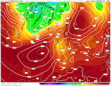
500 hPa geopotential and sea-surface pressure
over Europe,
04.09 18 UTC
Source: wetterzentrale
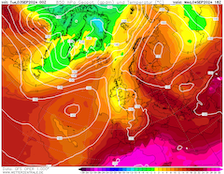
| 850 hPa temperature over Europe,
04.09 18 UTC
Source: wetterzentrale
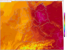
| Maximum 2 m temperature over Germany,
04.09 18 UTC
Source: wetter3
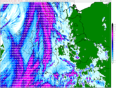
| Accumulated precipitation over Germany,
until 05.09 06 UTC
Source: wetter3
|
Heat, unseasonable warmth
Europe
Issued: Tuesday, September 03, 2024, 10:00 UTC
Another temperature peak is expected to bring temperatures of up to 35 °C to Eastern Germany on September 04, 2024. Well-above-average temperatures in Central Europe are likely to continue until at least September 10, 2024.
03.09.2024
Ahead of a trough moving from the British Isles southward, very warm air masses are advected into Central Europe. 850 hPa temperatures are forecasted to reach up to 20 °C. Both today, September 03, 2024, and tomorrow September 04, 2024, temperatures of more than 30 °C must be expected in Eastern Germany. The highest temperatures of up to 35 °C are forecasted in an area between Schwerin to the north, Magdeburg to the west, Berlin to the east, and Leipzig to the south. Currently, it seems unlikely that a measuring site will surpass the monthly record for September of 36.5 °C set 113 years ago in Jena.
On September 04, 2024, a stark temperature contrast will develop over Germany. Ahead of the trough over Western Europe, a precipitation band will bring locally heavy rains. This leads to temperatures near the 20 °C mark. In a narrow strip stretching from south to north over Germany, precipitation totals of more than 20 mm are forecasted. Local accumulations may surpass the 50 mm mark.
In the following days, the uncertainty over Europe remains large, as the trough over Western Europe evolves into a cut-off low over France. Over Scandinavia, a large ridge develops stretching westwards into the Eastern Atlantic. As a result, very warm airmasses are advected into Central and Eastern Europe, bringing well-above-average temperatures. In the last few days, global EPS have been consistent in the assessment that the temperatures decline to seasonal values in Central Europe after September 10, 2024.
Saturday, August 31, 2024, 10:30 UTC
|
|
|
|
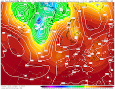
500 hPa geopotential and sea-surface pressure
over Europe,
31.08 12 UTC
Source: wetterzentrale
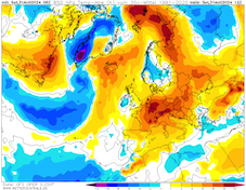
| 850 hPa temperature deviation over Europe,
31.08 12 UTC
Source: wetterzentrale
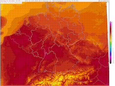
| Maximum 2 m temperature over Germany,
01.09 18 UTC
Source: wetter3
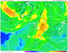
| 850 hPa temperature mean and spread
over Europe,
06.09 00 UTC
Source: wetterzentrale
|
Heat, unseasonable warmth
Europe
Issued: Saturday, August 31, 2024, 10:30 UTC
Well-above-average temperatures continue to persist in large parts of Europe well into the first decade of September. A late-summer heatwave is continuing to impact Central Europe with temperatures of up to 34 °C along the Upper Rhine Valley.
31.08.2024
A complex ridge pattern is currently residing over Europe, stretching far eastwards into Eurasia. With the ridge, unseasonably warm air masses are advected into Europe with 850 hPa deviations of up to 10 K. Over the weekend, an extremely warm air mass for late August/early September is expected to reach Central Europe with 850 hPa temperatures reaching up to 20 °C. As a result, daily maximum temperatures of up to 34 °C are possible in Southern Germany. The highest temperatures are most likely to occur in the Upper Rhine Valley.
On Monday, September 02, 2024, a trough over the Eastern Atlantic reaches Western Europe and leads to increased atmospheric instability. Both on Monday, September 02, 2024, and Tuesday, September 03, 2024, convective activity must be expected across Western and Central Europe.
At the southern tip of the trough, a cut-off will likely form over Western Europe. The erratic nature of cut-off lows leads to a large forecast uncertainty after Tuesday, September 03, 2024. Currently, most global EPS favor the continuation of well-above-average temperatures over Central Europe with a large ridge expanding across Western Europe. In the period from September 06, 2024, to September 09, 2024, most models suggest that 30+ °C temperatures are possible once again.
The latest global EPS forecasts suggest that only after September 10, 2024, temperatures could slowly adjust to seasonable values. Along the Alps at lower elevations, up to 10 straight days with temperatures of more than 30 °C are possible.
Wednesday, August 28, 2024, 09:00 UTC
|
|
|
|
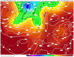
500 hPa geopotential and sea-surface pressure
over Europe,
29.08 12 UTC
Source: wetterzentrale
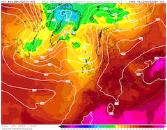
| 850 hPa temperature over Europe,
29.08 12 UTC
Source: wetterzentrale
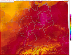
| Maximum 2 m temperature over Germany,
29.08 18 UTC
Source: wetter3
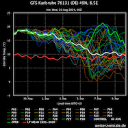
| 850 hPa temperature ensemble
for Karlsruhe, BW,
until 10.09 00 UTC
Source: wetterzentrale
|
Heat, unseasonable warmth
Europe
Issued: Wednesday, August 28, 2024, 09:00 UTC
A persistent omega-pattern is expected to bring a prolonged period of well above-average temperatures to large parts of Europe. In the coming days, a potent late summer heat wave is expected to develop across Europe. In Southern Europe, temperatures of more than 35 °C are possible. In Central Europe, maximum temperatures of up to 35 °C are likely.
28.08.2024
In the last 12 months, prolonged periods of strong ridges residing over Europe were rare. In the last decade of August 2024, a strong ridge from the Mediterranean has expanded across Europe. With a strong trough at the western flank of said ridge, a strong meridional weather pattern has developed over Europe. As a result, unseasonably warm air masses are advected into Europe. Over Southern Europe, 850 hPa temperatures reach up to 25 °C. In Central Europe, 850 hPa temperatures of up to 20 °C are possible.
With a trough approaching over the British Isles, the advection of very warm air masses into Central Europe is exacerbated. Hence, a pronounced heat wave is expected to impact Central Europe. Today, August 28, 2024, and tomorrow, August 29, 2024, maximum temperatures of more than 30 °C are forecasted. Along the Upper Rhine and in Eastern Germany, daily maximum temperatures of up to 35 °C are possible tomorrow.
On Friday, August 30, 2024, the trough over the North Sea will impact the weather across Central Europe, bringing convective activity to the central part of Germany. Concurrently, the northern and central parts of Germany will see a slight temperature decrease due to the inflow of cooler air masses on the backside of the trough. Likely, these air masses will not be able to penetrate Southern Germany.
In the following days into early September, the omega pattern across Europe is expected to move slowly eastward as repeated troughs/cut-off lows will impact Western and Central Europe. This leads to a substantial weather forecast uncertainty, with a tendency of cooler and wetter weather maturing by September 05, 2024, currently.
Currently, the deterministic runs of the global weather models show a very persistent omega pattern over Europe, with the ensembles supporting well-above-average temperatures until at least September 05, 2024. Mean 850 hPa temperatures remain more than 5 K above average for at least 8 days over Southern Germany. The deterministic runs show an 850 hPa temperature deviation of 10 K for the entirety of the first decade of September. As a result, well above-average temperatures especially in Southern Germany will likely persist into September. Some lower elevation sites in Southern Germany could see as much as 10 straight days of 30+ °C days into early September.
Tuesday, September 03, 2024, 10:00 UTC
KG
Saturday, August 31, 2024, 10:30 UTC
KG
Wednesday, August 28, 2024, 09:00 UTC
KG
|


