Monday, August 12, 2024, 14:00 UTC
|
|
|
|
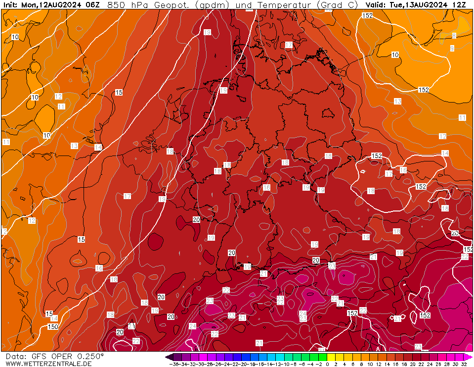
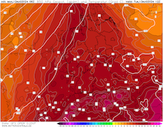
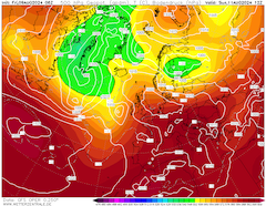
850 hPa temperature over Central Europe,
13.08 12 UTC
Source: wetterzentrale
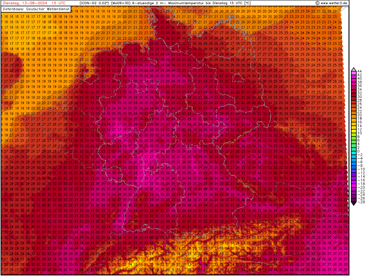
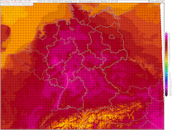
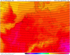
| Maximum 2 m temperature over Germany,
13.08 15 UTC
Source: wetter3
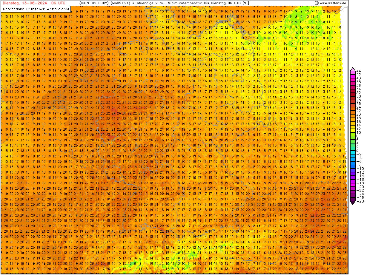
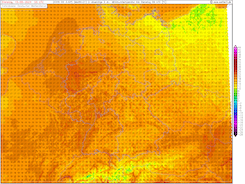
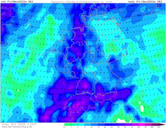
| Minimum 2 m temperature over Germany,
13.08 06 UTC
Source: wetter3
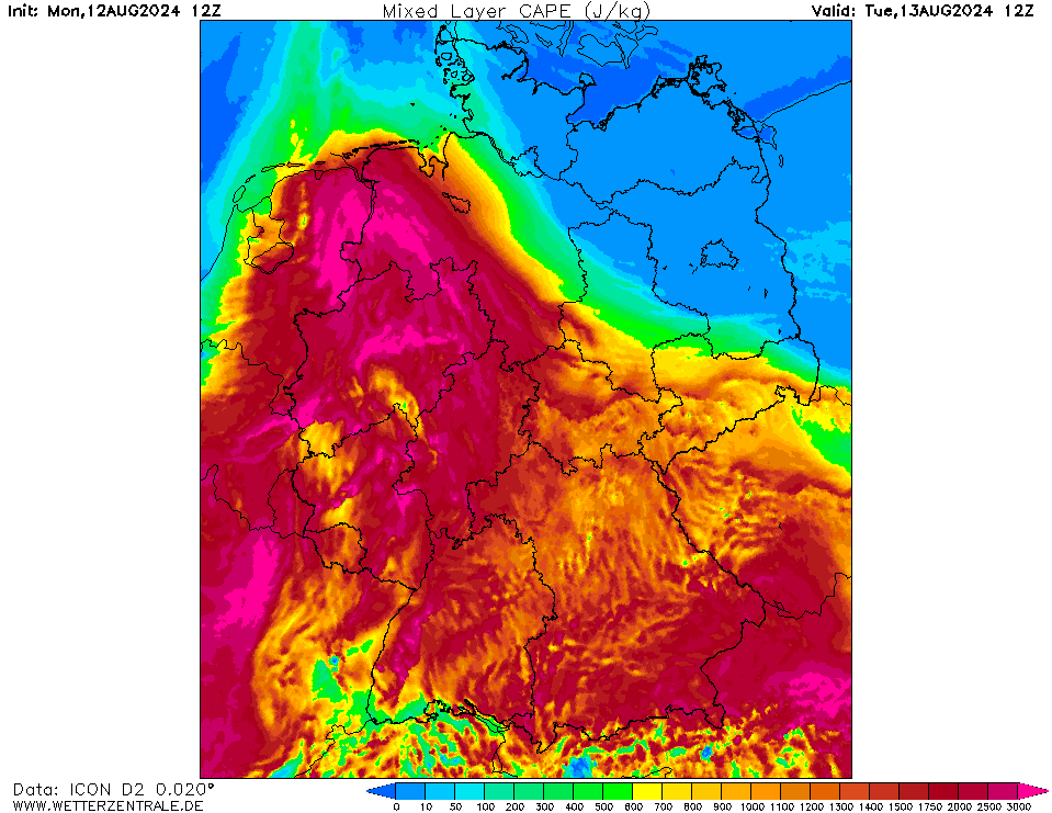
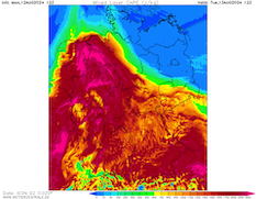
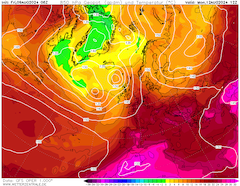
| Mixed-layer CAPE over Germany,
13.08 12 UTC
Source: wetterzentrale
|
Heat, Thunderstorms
Central Europe
Issued: Monday, August 12, 2024, 14:00 UTC
A strong heat wave is persisting across Central Europe. With 850 hPa temperatures expected to rise above the 20 °C mark, daytime maximum temperatures are expected to reach 36 °C. The heat stress will be exacerbated by very high dewpoints reaching more than 20 °C.
12.08.2024
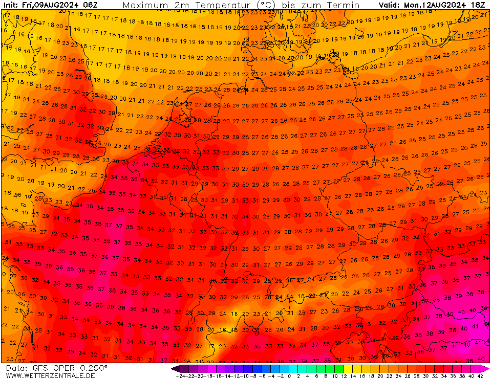
A strong ridge has expanded across Central Europe advecting very warm air masses into Central Europe. 850 hPa temperatures are forecasted to reach more than 20 °C, over the Alps 850 hPa temperatures can reach up to 25 °C. As a result, 2 m air temperatures at lower elevations will reach 35 °C today, August 12, 2024, and tomorrow August 13, 2024. On August 13, 2024, the highest temperatures are forecasted along the Rhine Valley in Western Germany. Locally, daily maximum temperatures of 37 °C may be reached.
Very high heat stress across large parts of Germany must be expected. The heat stress is mainly driven by very high dew points and high overnight temperatures in the night from August 12, 2024, to August 13, 2024. In many parts of Western Germany, the dewpoints will reach more than 20 °C. Locally, dewpoints of up to 22 °C are possible. In the night from August 12, 2024, and August 13, 2024, nighttime temperatures in metropolitan areas of Western Germany will stay above the 20 °C mark. Some cities in North Rhine-Westphalia may see overnight low temperatures as high as 25 °C.
While convective activity today, August 12, 2024, will be mainly limited to Southern Germany where orographic forcing is the strongest, more widespread convective activity is forecasted to occur tomorrow, August 13, 2024. The combination of the high moisture content and very high temperatures over Western Germany will create an environment with very high CAPE values over 2000 J/kg, rare for this region. Due to the lack of a frontal forcing, the convection will find little to no shear to form organized convection. Currently, the most likely scenario is for single cellular convection to form in the afternoon and evening hours due to the diurnal insolation. Initiation is likely triggered in regions with orographic forcing. In the evening and nighttime hours, clustering of the cells is likely and may be leading to further convective activity.
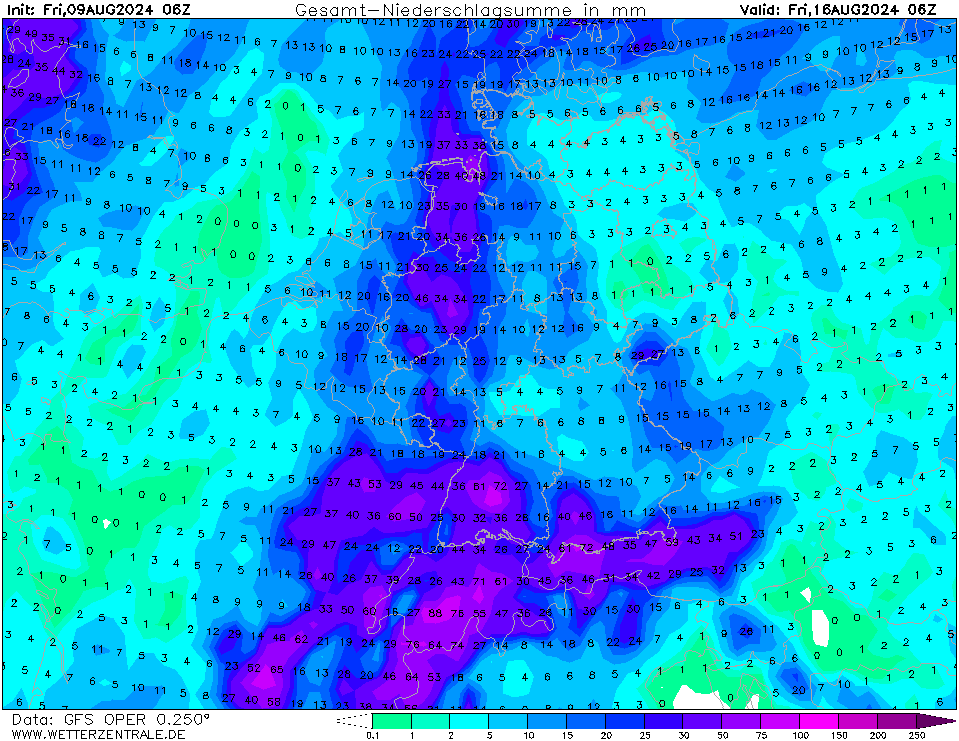
Due to the weak mid-level winds, the cells will likely be stationary or moving very slowly. In combination with the high water content of the atmosphere, precipitable water of more than 40 mm, localized flash-flooding due to extreme downpours is likely. Locally, hourly precipitation rates of more than 50 mm are likely. Other convectively related dangers are less likely to occur due to the low degree of organization of the convection. Further, it must be noted that there is a large spread between models regarding to extent of the convective activity on August 13, 2024.
On August 14, 2024, the approaching trough over the British Isles will provide mid-level lifting to initiate convective activity across Central Europe. More convective organization is expected, but the forecast is uncertain. Uncertainty is caused by potential lingering convective remnants of the previous day affecting further convective development.
Friday, August 09, 2024, 11:00 UTC
|
|
|
|
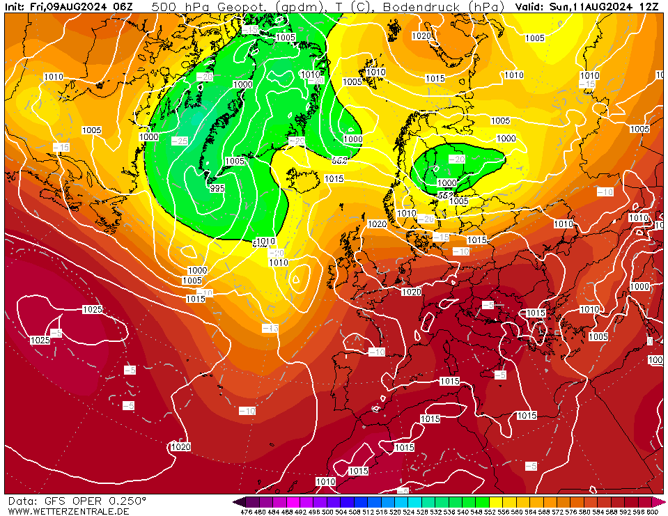
500 geopotential and mean sea-surface pressure
over Europe,
11.08 12 UTC
Source: wetterzentrale
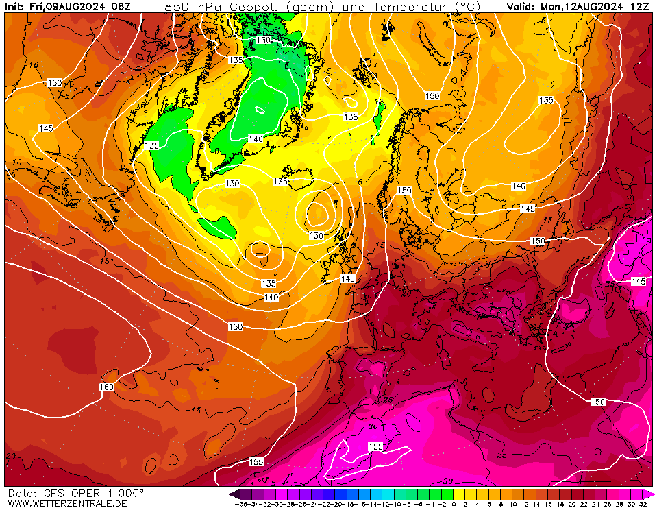
| 850 hPa temperature over Europe,
12.08 12 UTC
Source: wetterzentrale
| Maximum 2 m temperature over Central Europe,
12.08 18 UTC
Source: wetterzentrale
| Accumulated precipitation over Central Europe,
until 16.08 06 UTC
Source: wetterzentrale
|
Heat
Europe
Issued: Friday, August 09, 2024, 11:00 UTC
A strong ridge across Europe will induce a prominent heat wave across Western and Central Europe in the coming days. With 850 hPa temperatures reaching more than 20 °C, near-surface temperatures are expected to surpass the 35 °C mark.
09.08.2024
While Southern and Southeastern Europe have experienced prolonged heat waves in the summer of 2024, the central and western parts of Europe have seen no major heat waves this summer thus far. In Germany, the mean maximum temperature of the summer is currently the lowest since the summer of 2004. In the coming days, a strong ridge from the Mediterranean will extend over Europe. In combination with a strong trough system over Northern Europe, very warm air masses will be advected into the western and central parts of Europe.
On August 11, 2024, a plume of extremely warm air masses with 850 hPa temperatures of more than 25 °C will move northeastwards from the Iberian Peninsula into France and Central Europe. In Southern France, temperatures of more than 40 °C must be expected with the highest temperatures forecasted in the region south of Bordeaux. With an approaching trough over the Eastern Atlantic, the plume will move northeastwards across Europe. On August 12, and August 13, 2024, temperatures in France and southwestern Germany are expected to rise to the 35 °C mark or slightly above. Though, the temperature forecast for August 13, 2024, shows higher uncertainty.
This uncertainty is caused by the nearing trough over the Eastern Atlantic. With mid-level lifting provided by the trough enhanced convective activity over Western and Central Europe must be expected as the trough nears. Over France, strong activity will already commence on August 13, 2024, while over Germany widespread convective activity is forecasted for August 14, and August 15, 2024. The severity of this convective outbreak is still uncertain. Though with high confidence, much cooler air masses will reach Western and Central Europe once the trough has reached Europe, leading to much cooler temperatures starting mid-next week.
Monday, August 12, 2024, 14:00 UTC
KG
Friday, August 09, 2024, 11:00 UTC
KG
|