Thursday, May 23, 2024, 09:00 UTC
|
|
|
|
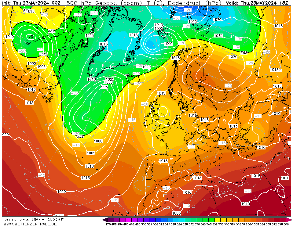
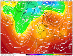
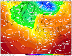
500 hPa geopotential and mean sea-surface pressure
over Europe,
23.05 18 UTC
Source: wetterzentrale
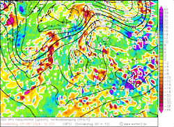
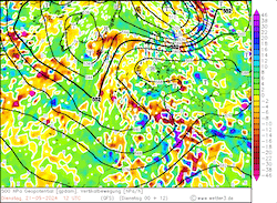
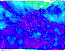
| 500 hPa omega velocity and geopotential
over Europe,
23.05 12 UTC
Source: wetter3
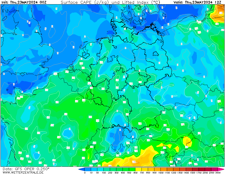
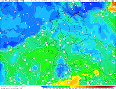
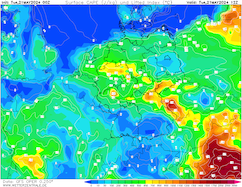
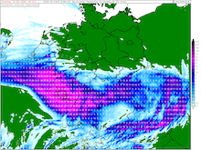
| Surface-based CAPE and lifed index
over Central Europe,
23.05 12 UTC
Source: wetterzentrale
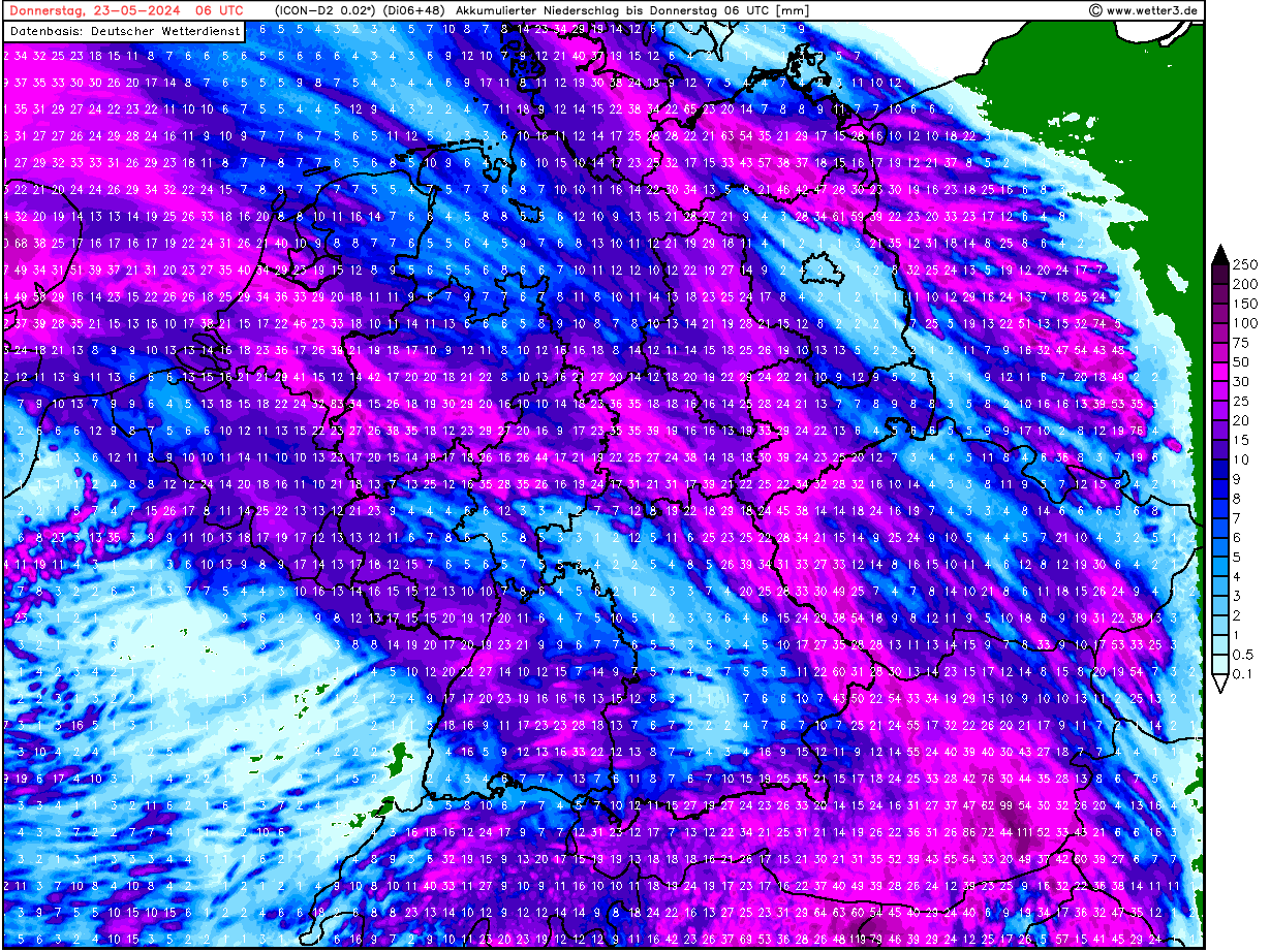
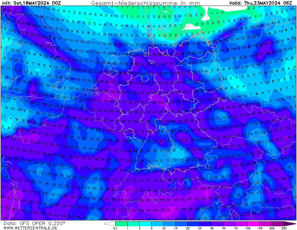
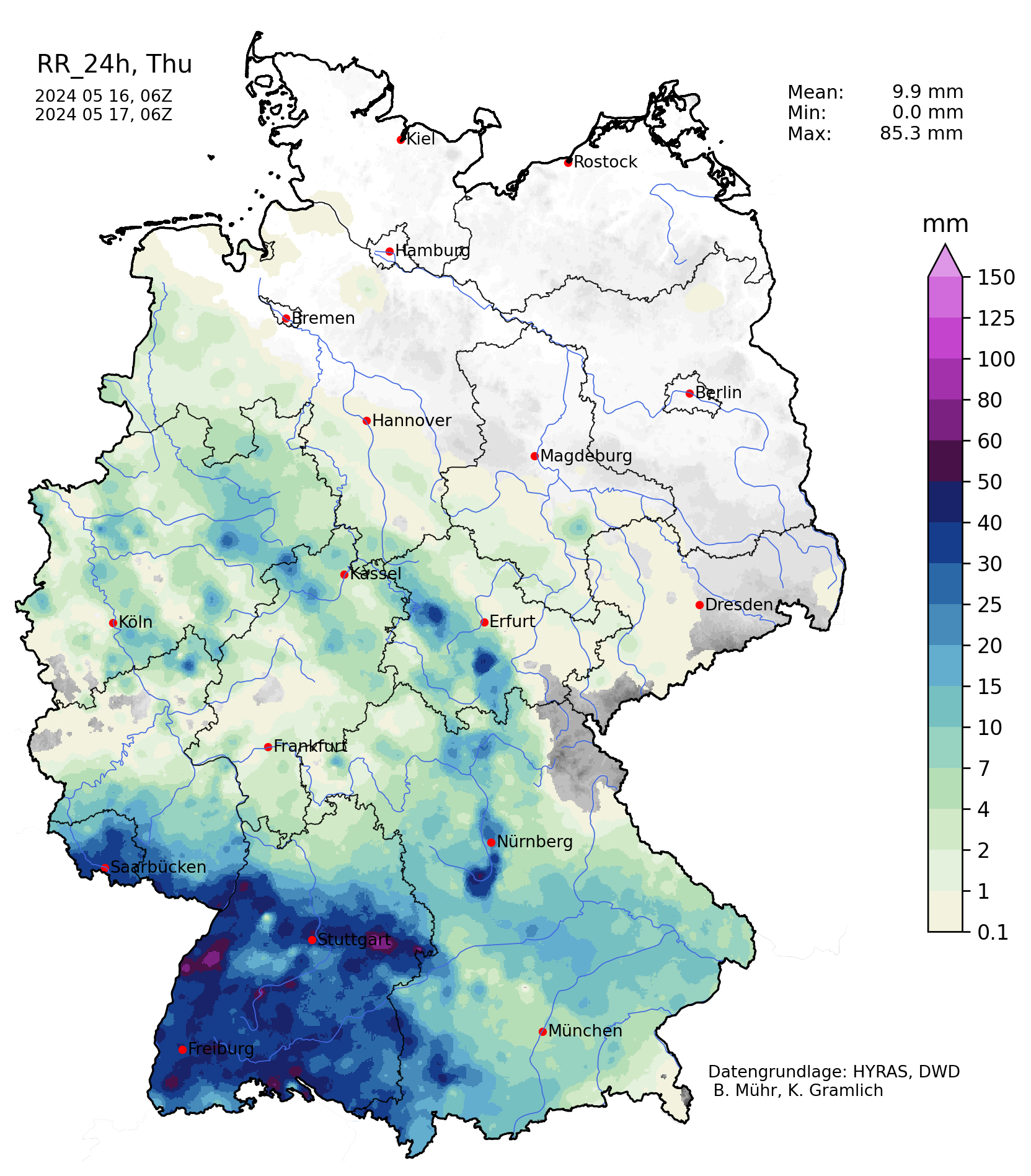
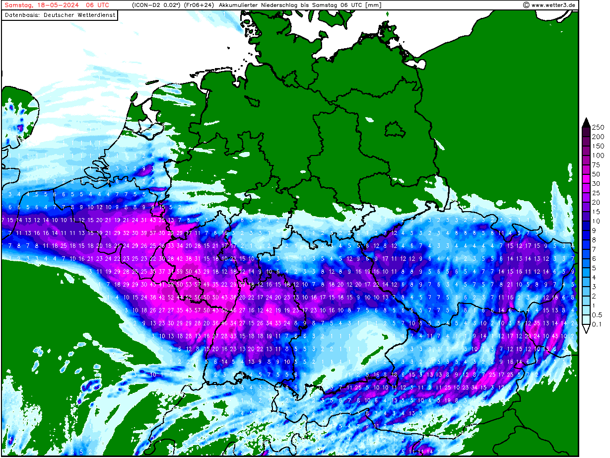
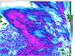
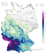
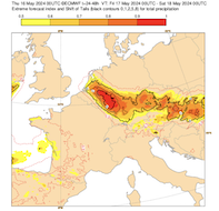
| Accumulated precipitation over Germany
until 25.05 06 UTC
Source: wetter3
|
Heavy rains, river flooding
Western Germany
Issued: Thursday, May 23, 2024, 09:00 UTC
The warning for heavy rains and strong thunderstorms is extended as another low-pressure system ahead of the trough over the British Isles is expected to induce strong convective activity over parts of Germany. 24 h precipitation totals of up to 40 mm are possible. Localized flooding must be expected.
23.05.2024
Since last week, the weather pattern over Europe has been dominated by an Omega weather pattern. As a result, multiple low-pressure systems ahead of a trough over the British Isles, bringing heavy precipitation to Germany. Later today, May 23, 2024, another low-pressure system is expected to move northwards across Germany from south to north. As previously, the combination of the surface low ahead of the trough will provide mid-level lifting. Combined with daytime heating, the potential strong convective activity is given over the southern part of Germany. The heaviest rains are expected in the region between Stuttgart and Munich, with precipitation totals of up to 40 mm.
Throughout the night to May 24, 2024, the thunderstorms are expected to form a broad mesoscale rain complex moving northwestwards across Germany. Currently, it is expected that that rain complex is moving across the western half of Germany, bringing up to 30 mm of rain within a few hours. Higher precipitation totals could mature in parts of North Rhine-Westphalia on Friday, May 24, 2024, due to the formation of embedded thunderstorms.
Tuesday, May 21, 2024, 08:00 UTC
|
|
|
|
500 hPa geopotential and mean sea-surface pressure
over Europe,
21.05 18 UTC
Source: wetterzentrale
| 500 hPa omega velocity and geopotential
over Europe,
21.05 12 UTC
Source: wetter3
| Surface-based CAPE and lifed index
over Central Europe,
21.05 12 UTC
Source: wetterzentrale
| Accumulated precipitation over Germany
until 23.05 06 UTC
Source: wetter3
|
Heavy rains, river flooding
Western Germany
Issued: Tuesday, May 21, 2024, 08:00 UTC
Another round of heavy precipitation entangled with strong precipitation is expected over Germany later today. The areas that were subjected to severe flooding last week will see precipitation totals of up to 30 mm, further northeast precipitation totals of more than 50 mm are possible. There is an elevated risk of flash flooding and mudslides.
21.05.2024
Like last week, a surface low is moving slowly northwards across Germany, located ahead of a trough over the British Isles and France. The combination of the trough and the surface low will provide mid-level lifting sufficient for producing continuous precipitation and strong thunderstorms. In the first half of today, May 21, 2024, continuous precipitation is expected over the flooding regions of the previous week in the Saarland and Palatine region. Here, precipitation totals of up to 30 mm are possible. As a result, the minor rivers in said region are expected to rise again, but not reach the flooding stages from last week. Nevertheless, the oversaturated soils are prone to produce mudslides.
Further northeast, in a belt stretching from the German-Austrian border over Frankfurt, Cologne into the Netherlands, heavy continuous precipitation entangled with strong thunderstorms is expected. Spanning until tomorrow morning, May 22, 2024, precipitation totals of up to 50 mm are possible. Some models suggest that local precipitation totals of up to 80 mm are possible. As a result, river flooding and mudslides are possible.
Both tomorrow, Wednesday, May 22, 2024, and Thursday, May 23, 2024, heavy precipitation is possible in parts of Eastern Germany. Here precipitation totals of more than 50 mm are possible. The forecasted precipitation would reduce drought concerns in the region, which received only sparse precipitation this month.
Saturday, May 18, 2024, 09:30 UTC
|

|
|
|
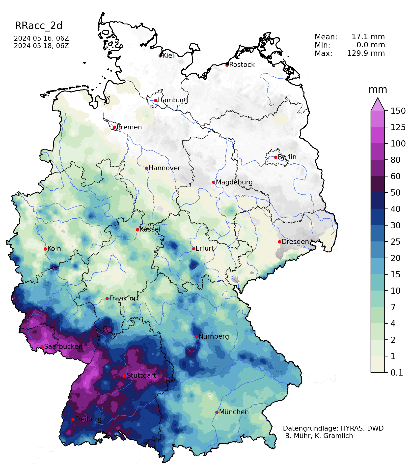
48 h precipitation totals
over Germany,
18.05 06 UTC
Source: Wegefrüh
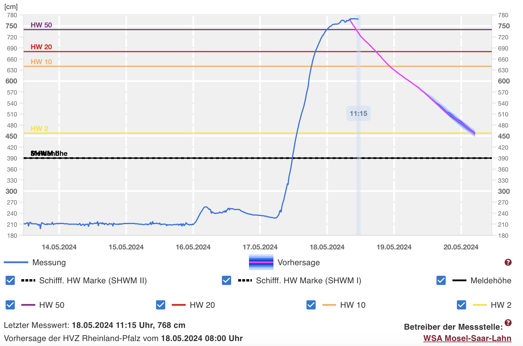
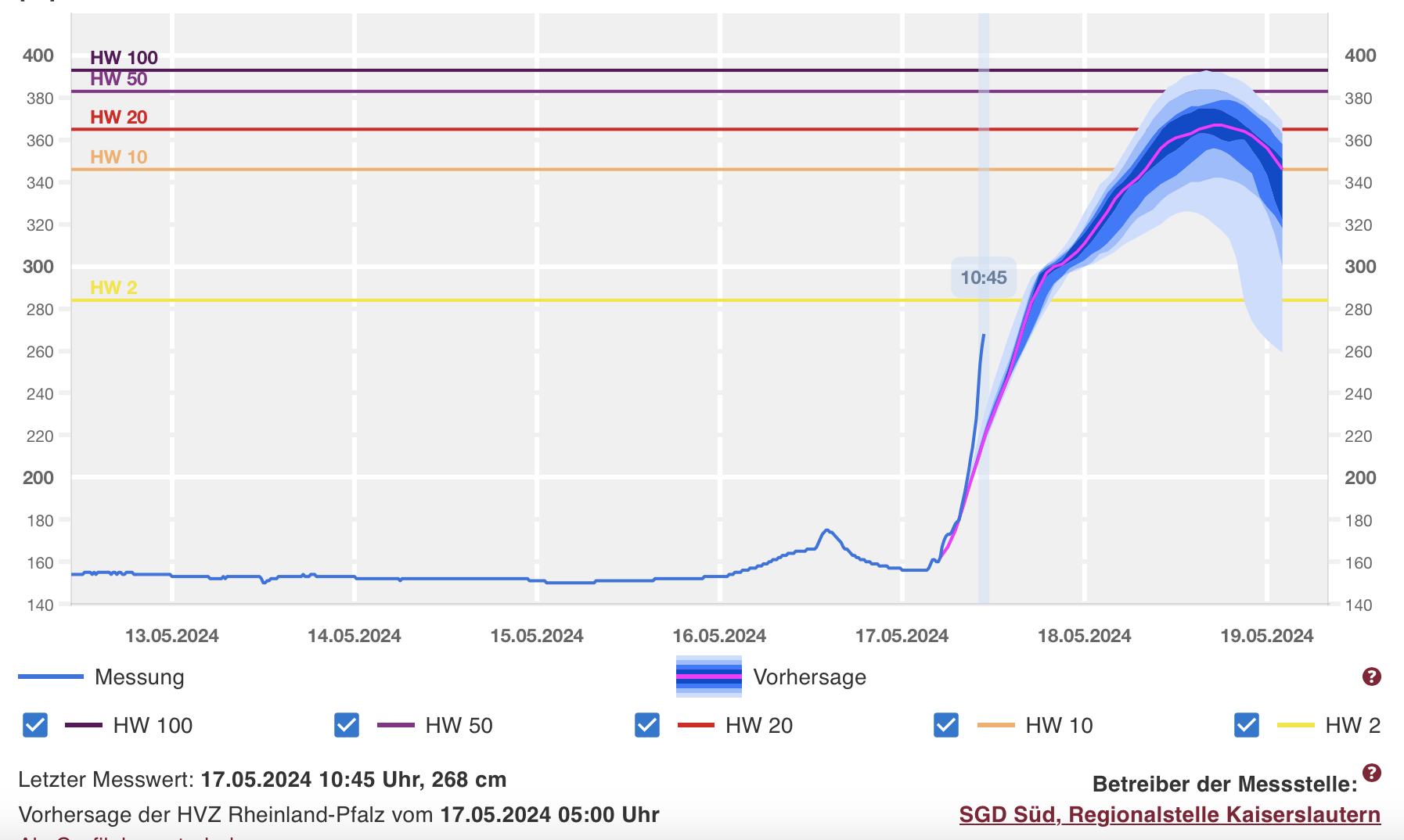
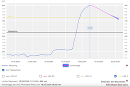
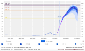
| River level forecast for the river gauge
at Fremersdorf, Saar
until 20.05 06 UTC
Source: Hochwasser RLP
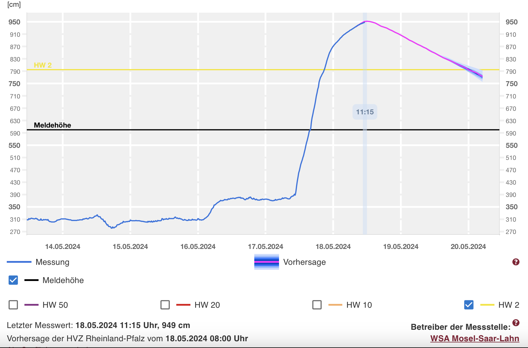
| River level forecast for the river gauge
at Trier, Moselle
until 20.05 06 UTC
Source: Hochwasser RLP
| Accumulated precipitation over Germany
until 23.05 06 UTC
Source: wetterzentrale
|
Heavy rains, river flooding
Western Germany
Issued: Saturday, May 18, 2024, 09:30 UTC
Low Katinka brought intense rains to parts of Western Germany, 48 h precipitation totals reached more than 120 mm. Due to the intense rains, severe river flooding is observed in the Palatine region and the Saarland. Along the Saar River, a 50-year flood is occurring.
18.05.2024
Throughout the day on Friday, May 17, 2024, intense precipitation was observed in the Saarland and the southern part of the Palatine region. Within a 24 h period, precipitation totals of more than 100 mm were observed. As a result of this intense precipitation, severe river flooding was observed in the region. Especially along some minor rivers of the Palatine region, hundred-year flood marks were surpassed. Most of these rivers have reached the highest during the last night and are now slowly receding.
Most of these rivers drain into the Saar River, which is currently running at extreme flooding stages, above the 50-year flood mark. At the measuring gauge at Fremersdorf, the Saar River has reached a record-breaking level of 769 cm, which is 25 cm higher than the high water mark during the severe floods of December 1993. Downstream the Saar River drains into the Moselle River where river levels above the 2-year flood mark are expected. Along these rivers, road closures and residential flooding must be expected.
The warning will be tentatively extended until next Thursday, May 23, 2024, due to the potential for heavy rains on Tuesday, May 21, 2024, and Wednesday, May 22, 2024. The intensity and location of these rains are still very uncertain.
Friday, May 17, 2024, 09:00 UTC
|

|
|
|
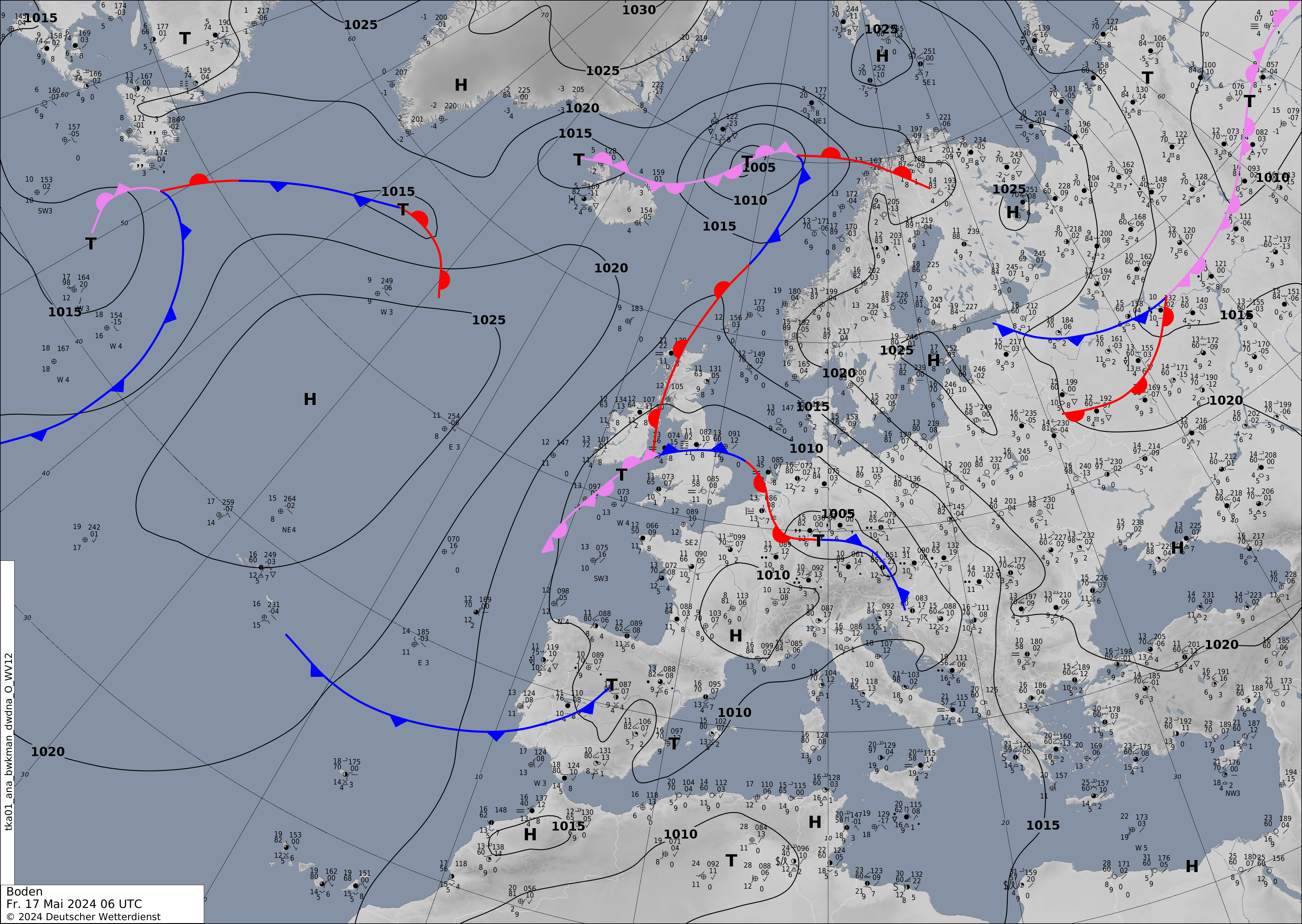
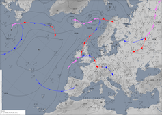
Sea-surface pressure and analyzed fronts
over Europe,
17.05 06 UTC
Source: DWD
| 1-day accumulated precipiation
over Germany,
17.05 00 UTC
Source: wettergefahren-fruehwarnung
| Accumulated precipitation over Central Europe
until 18.05 06 UTC
Source: wetter3
| River level forecast for the river gauge
at Contwig, Schwarzbach
until 18.05 06 UTC
Source: Hochwasser RLP
|
Heavy rains, river flooding
Western Germany
Issued: Friday, May 17, 2024, 09:00 UTC
The threat of heavy rains due to low Katinka continues throughout the day. Throughout today, May 17, 2024, further precipitation is expected, especially in the Palatine region and the Saarland. Precipitation totals of 30 to 50 mm are expected. Especially along minor rivers and creeks feeding into the Saar and Glan Rivers, river flooding must be expected throughout the day.
17.05.2024
After observed precipitation totals of around 50 mm in the night from Thursday, May 16, 2024, to Friday, May 17, 2024, stretching from the central part of Baden-Württemberg over the Palatine into the Saarland. Currently, the surface low is located over Central Germany with its center close to the city of Frankfurt. South of the pressure minimum, a broad precipitation band is stretching above the above-mentioned region.
In the overnight hours from Thursday, May 16, 2024, to Friday, May 17, 2024, a small surface low is expected to develop over the southern part of Germany. The surface low ahead of the trough will provide lifting over the western half of Germany. Throughout the day on Friday, the surface low will slowly move northwards, with the highest precipitation totals expected west of the pressure minimum. Due to the slow movement of said surface low, continuous heavy rains are expected to impact the western half of Germany.
Here, further heavy precipitation is expected, accumulations of 30 to 50 mm must be expected. As a result, quickly rising river levels must be expected. Especially in the Palantine region and in the Saarland, the highest threat for river flooding is forecasted. The highest flooding stages are expected along minor rivers and creeks feeding into the Saar and Glan Rivers. Flooding stages higher than a 20-year flood are likely. Some rivers may rise to 50-year flooding levels. Along the Moselle River, a 2-year flood is possible.
Thursday, May 16, 2024, 09:30 UTC
|
|
|
|
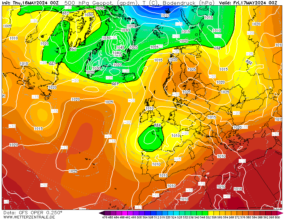
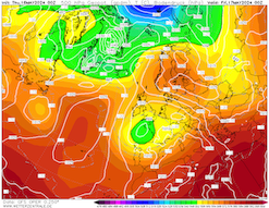
500 hPa geopotential and mean sea-surface pressure
over Europe,
17.05 00 UTC
Source: wetterzentrale
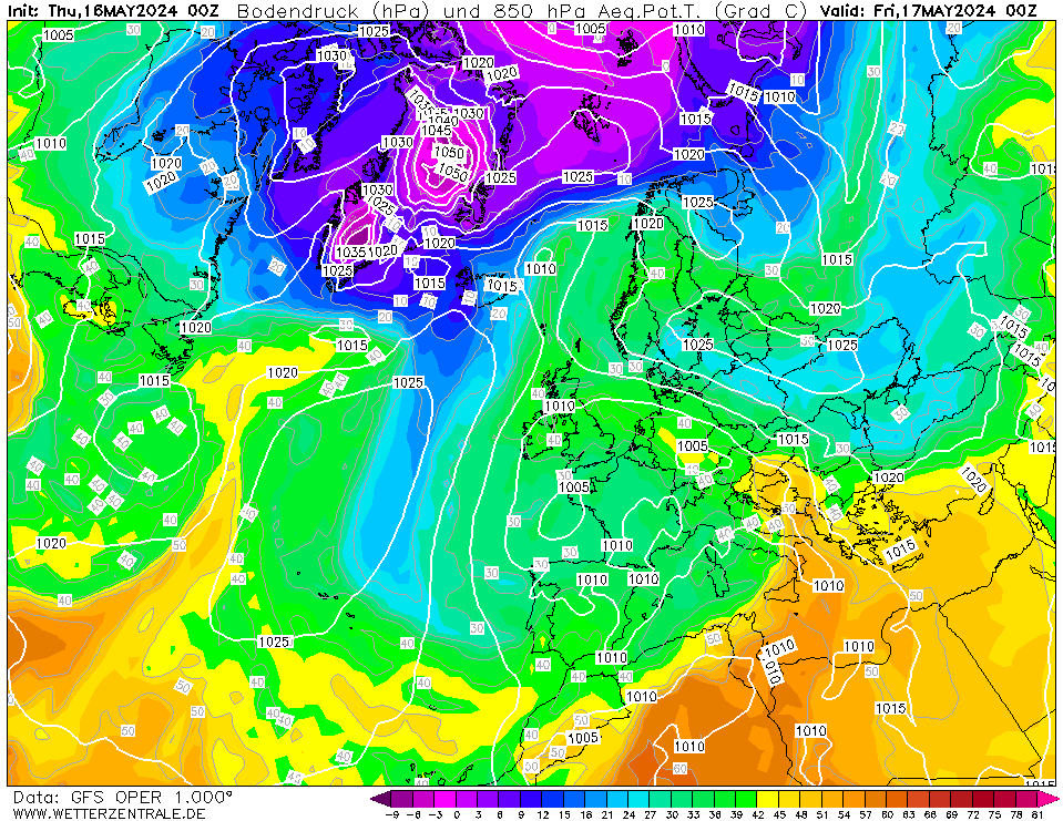
| 850 hPa pseudo-potential temperature and
mean sea-surface pressure
over Europe,
17.05 00 UTC
Source: wetterzentrale
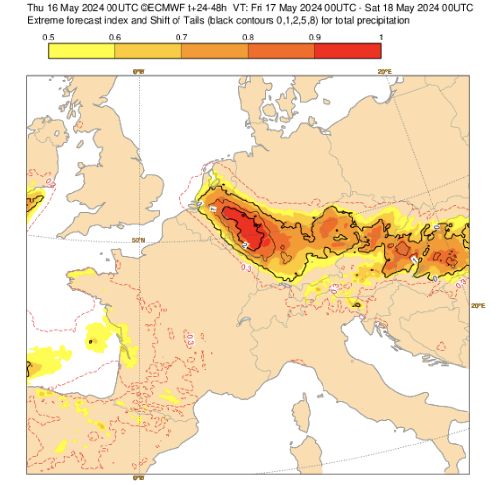
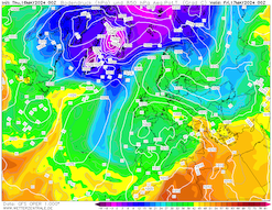
| EFI and SOT index
for the daily precipiation totals
over Central Europe,
17.05
Source: ECMWF
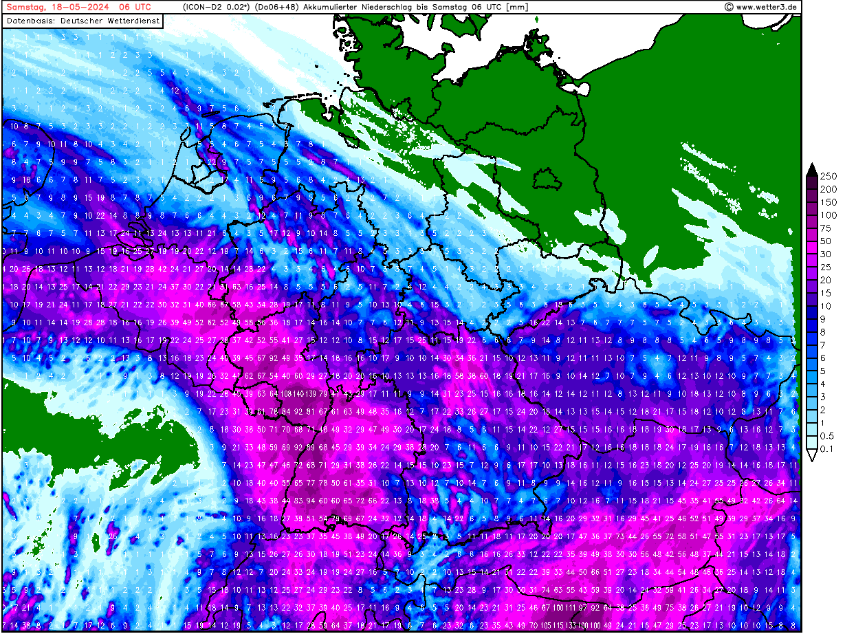
| Accumulated precipitation over Central Europe
until 18.05 06 UTC
Source: wetter3
|
Heavy rains, river flooding
Western Germany
Issued: Thursday, May 16, 2024, 09:30 UTC
A trough over the British Isles moving into Western Europe underneath a ridge over Scandinavia is expected to bring abundant precipitation to parts of Western Germany and neighboring states. 24 h precipitation totals of more than 50 mm are expected, locally 24 h precipitation totals of more than 125 mm cannot be excluded. River flooding must be expected.
16.05.2024
In the western half of Germany, the first half of May has already been exceptionally wet, with parts of Northrhine-Westphalia and Rhineland-Palatine receiving the average monthly precipitation within the first ten days of the month. Since the Ascension Day weekend, the weather pattern over Europe has been dominated by a trough-ridge-trough pattern, known as an omega pattern. In the past days, the trough over the British Isles has been slowly eastwards, underneath the ridge located over Scandinavia. As a result, moist and warm air masses are advected into Central Europe.
In the overnight hours from Thursday, May 16, 2024, to Friday, May 17, 2024, a small surface low is expected to develop over the southern part of Germany. The surface low ahead of the trough will provide lifting over the western half of Germany. Throughout the day on Friday, the surface low will slowly move northwards, with the highest precipitation totals expected west of the pressure minimum. Due to the slow movement of said surface low, continuous heavy rains are expected to impact the western half of Germany.
Starting with strong thunderstorms in the early evening hours today, the heavy rains will slowly move northwards from the German-Swiss border. Early Friday morning, the heaviest rains are expected to reach the Northern Black Forest and the Upper Rhine Valley. By midday, the heaviest rains are expected to shift into Rhineland-Palatine. In the later stages of Friday, May 17, 2024, the precipitation band is expected to expand northwards into the Netherlands, even reaching the North Sea.
Currently, the highest precipitation is expected in a region around the Northern Black Forest stretching into the Palatine region. Here, 24 h precipitation totals of more than 70 mm must be expected, locally 24 h precipitation totals of more than 125 mm cannot be excluded, especially in the Northern Black Forest. Outside of the main focal point of this event 24 h precipitation totals of up to 50 mm must be expected. Please note that the exact location of the heaviest precipitation is still varying depending on the model forecast.
Nevertheless, in the formerly mentioned regions quickly rising river levels and mudslides must be expected on Friday, May 17, 2024, due to the already saturated soils in this region. Especially along smaller rivers and creeks in the Northern Black Forest and the Palatine region, severe river flooding cannot be excluded. In the case of an upper-end ensemble solution, a few minor rivers may reach up to 20-year flood levels or even higher. Precaution actions are strongly advised! Along the Rhine and Moselle River, river flooding may develop later this weekend depending on the severity of the event.
Thursday, May 23, 2024, 09:00 UTC
KG
Tuesday, May 21, 2024, 08:00 UTC
KG
Saturday, May 18, 2024, 09:30 UTC
KG
Friday, May 17, 2024, 09:00 UTC
KG
Thursday, May 16, 2024, 09:30 UTC
KG
|