Tuesday, January 16, 2024, 15:00 UTC
|
|
|
|
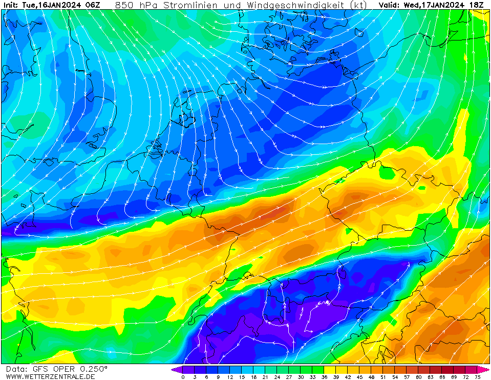
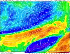
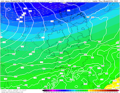
850 hPa streamlines and wind speed
over Central Europe,
17.01 18 UTC
Source: wetterzentrale
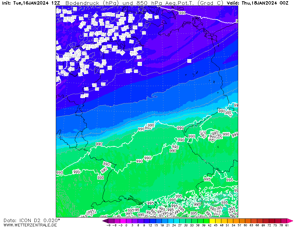
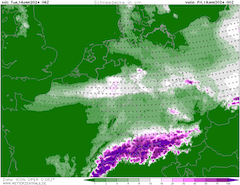
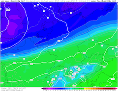
| 850 hPa pseudo-potential temperature and
sea surface pressure over Germany,
18.01 00 UTC
Source: wetterzentrale
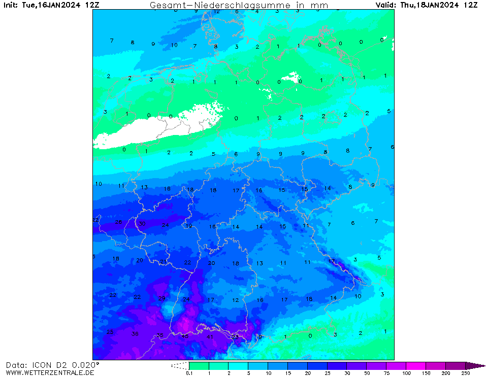
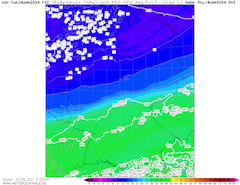
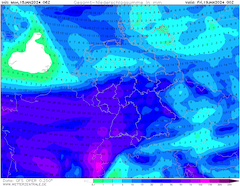
| Accumulated precipitation over Central Europe,
until 19.01 00 UTC
Source: wetterzentrale
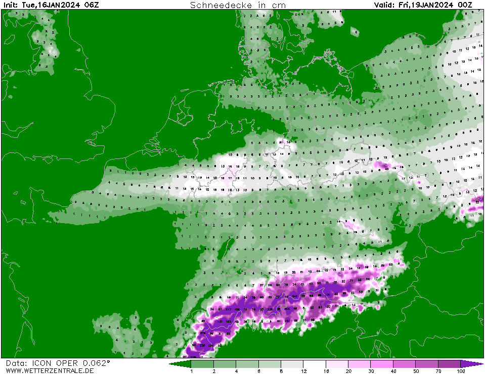
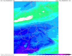
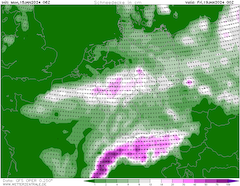
| Snow height over Central Europe,
19.01 00 UTC
Source: wetterzentrale
|
Heavy snow, Severe Icing
Central Europe
Issued: Tuesday, January 16, 2024, 15:00 UTC
Over the past 24 h, all NWP models converge against the airmass boundary developing over the central part of Rhineland-Palatine spanning eastwards. North of the airmass boundary fresh snow accumulations of 15 - 35 cm/24 h are possible, further south continuous freezing rain is likely with ice accumulations of multiple centimeters.
16.01.2024
A shallow surface low is expected to move from the Bay of Biscay eastwards into Central Europe on Wednesday, January 17, 2024. Upstream of the surface low, warm air masses will penetrate northwards, reaching the central part of Germany. A distinct airmass boundary with an 850 hPa temperature gradient of 10 K will be formed.
Current NWP model output converges against a location of the airmass boundary across Rhineland-Palatine, from here spanning across the central part of Germany, along a line of Moselle River, Koblenz, Frankfurt to the German-Czech border. North of this line, especially in the northern half of the Rheinish Massif, heavy continuous snowfall must be expected, stretching as far north as Bonn and as far east as Fulda. Here, between 15 to 35 cm/24 h of fresh snow accumulation is expected. Further to the east fresh snow accumulations are forecasted to be lower, in the realm of 20 cm. North of this line, snow accumulations are expected to reduce fast.
South of the airmass boundary, the light snowfall starting early Wednesday morning is expected to quickly transition into rain. At higher elevations, the warm air masses can penetrate more easily northwards, reducing the risk of large freezing rain accumulations. Nevertheless, widespread freezing rain must be expected in almost the entirety of Baden-Württemberg and Bavaria. Distinct temperature swings of more than 10 K within an hour or two must be expected as surface inversion is removed with temperatures at lower elevations reaching more than 10&thins;°C.
Close to the airmass boundary, the freezing rain is expected to persist for multiple hours as the near-surface inversion will prevent the warm airmasses from above from penetrating through to the surface. Especially in the region, spanning across Trier, Saarbrücken, Darmstadt, to Würzburg, heavy and continuous freezing rain is expected. With 24 h precipitation totals of more than 30 mm, ice accumulations of multiple centimeters must be expected. Prolonged freezing rain is more likely in rivers and other small valleys where the near-surface cold airmass is more sheltered. With the airmass boundary moving southeastwards in the night from Wednesday to Thursday, the freezing rain is expected to turn into snow again. North of Karlsruhe, fresh snow accumulations of more than 10 cm within a few hours on Thursday morning are expected currently.
Around the airmass boundary, treacherous traveling conditions are expected on Wednesday and Thursday, travelling is ill-advised. Especially in the region of continuous freezing rain, the impacts of the large ice accumulation are expected to be severe. The potential for downed powerlines and trees is given. Weather conditions are expected to improve Thursday evening.
Monday, January 15, 2024, 13:00 UTC
|
|
|
|
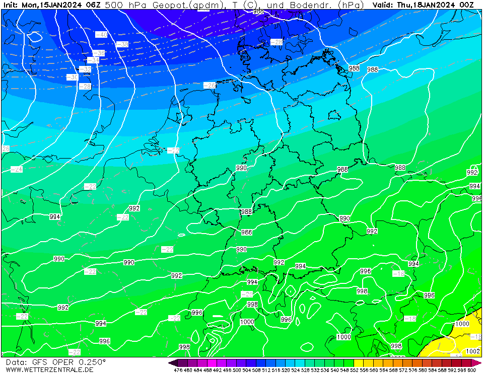
500 hPa Geopotential and sea surface pressure
over Central Europe,
18.01 00 UTC
Source: wetterzentrale
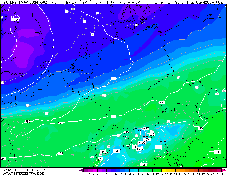
| 850 hPa pseudo-potential temperature and
sea surface pressure over Central Europe,
18.01 00 UTC
Source: wetterzentrale
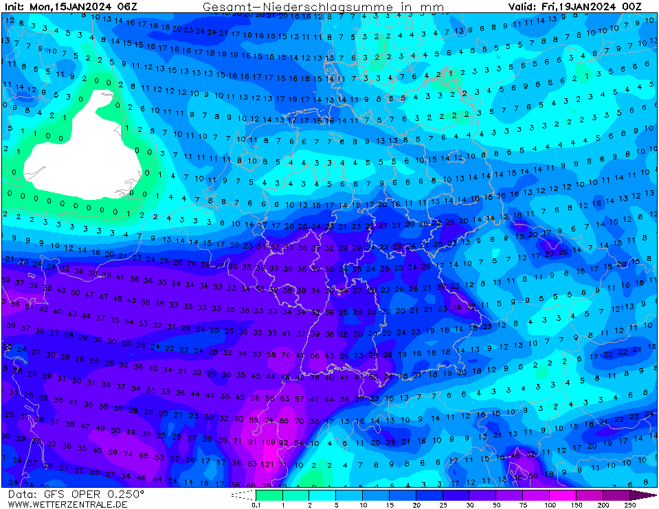
| Accumulated precipitation over Central Europe,
until 19.01 00 UTC
Source: wetterzentrale
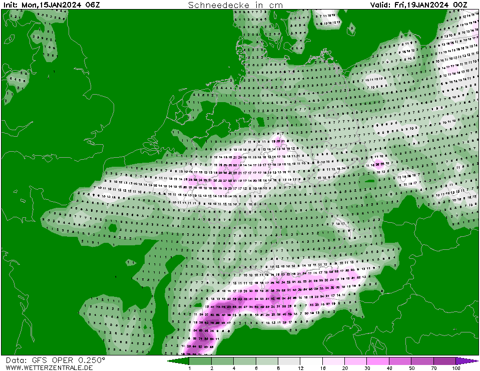
| Snow height over Central Europe,
19.01 00 UTC
Source: wetterzentrale
|
Heavy snow, Icing
Central Europe
Issued: Monday, January 15, 2024, 13:00 UTC
A strong airmass boundary, with 850 hPa temperature gradients of up to 10 K over Central Europe is expected to bring heavy snowfall and ice accumulation to a stretch spanning across the central part of Germany. 36 h fresh snow accumulations can reach up to 30 cm.
15.01.2024
A weak cold wave has been affecting Central Europe since early January with daytime temperatures reaching only slightly above freezing level at lower elevations. At the southern flank of a trough over Scandinavia, a shallow surface low is expected to develop over the Bay of Biscay. The surface low will move northeastwards into Central Europe on Wednesday, January 17, 2024.
The surface low will lead to the northward advection of warm and moist airmasses forming a distinct airmass boundary, spanning across Central Europe. The airmass boundary is most distinct in the 850 hPa pseudo-potential temperature field. In the 850 hPa field over Central Europe, a temperature gradient of up to 10 K is expected to build up on Wednesday.
Along the airmass boundary, continuous precipitation is expected. The airmass boundary will cause a very steep latitudinal gradient in the snowline across Central Europe. South of the airmass boundary, the warm intruding airmasses will bring rain. Especially at lower elevations and in narrow valleys, the conditions for continuous freezing rain are given, with possible ice accumulations of up to 1 cm. At higher elevations, the warm air masses will penetrate further northwards due to the slant airmass boundary in the atmosphere. A short-lived temperature increase of up to 10 °C must be expected along the Black Forest.
Current model output suggests that the snowline will be situated been Mainz and Cologne. North of this line, continuous moderate to heavy snow must be expected. Snowfall will begin Wednesday morning and stretch into Thursday, January 18, 2024. Precipitation totals up to 40 mm are expected in this region with the highest precipitation totals along westwards facing flanks of the hills in the middle part of Germany. Especially in the Rhenish Massif, fresh snow accumulations within a 36 h period of up to 30 cm must be expected.
Along the Rhine Valley, the large uncertainty of the location of the snowline makes the snowfall estimate very difficult. Currently, even the cities along the Rhine River between Mainz and Cologne could receive up to 20 cm of snow until Thursday evening. The shift from the warm side of the airmass boundary at the surface is expected to be very sharp. Shifts of the latitudinal location snow and ice precipitation must be expected. Further eastwards, the precipitation totals are expected to be lower, providing fresh snow accumulations of up to 20 cm. Treacherous traveling conditions must be expected in the central part of Central Europe on Wednesday and Thursday.
Tuesday, January 16, 2024, 15:00 UTC
KG
Monday, January 15, 2024, 13:00 UTC
KG
|