Friday, November 03, 2023, 15:00 UTC
|
|
|
|
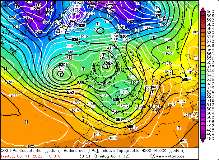
500 hPa Geopotential and sea surface pressure
over Europe, 03.11 18 UTC
Source: wetter3
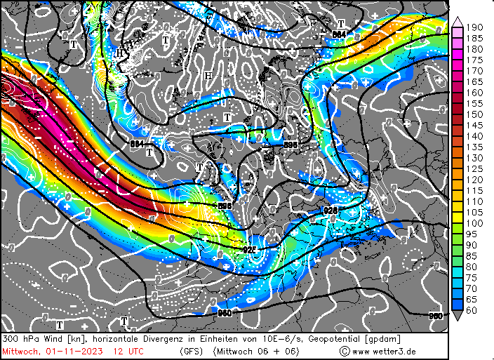
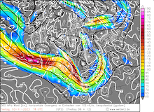
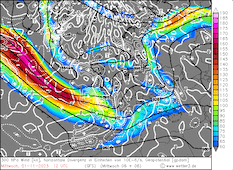
| 300 hPa Geopotential and wind speeds
along with the 300 hPa divergence
over Europe,
03.11 18 UTC
Source: wetter3
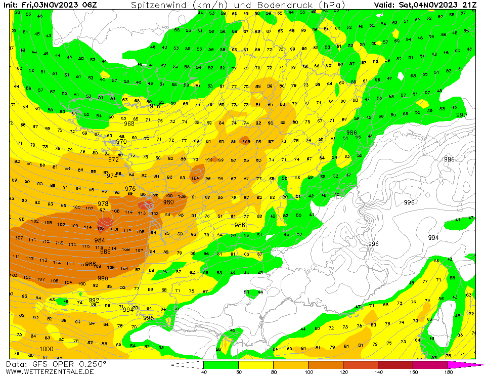
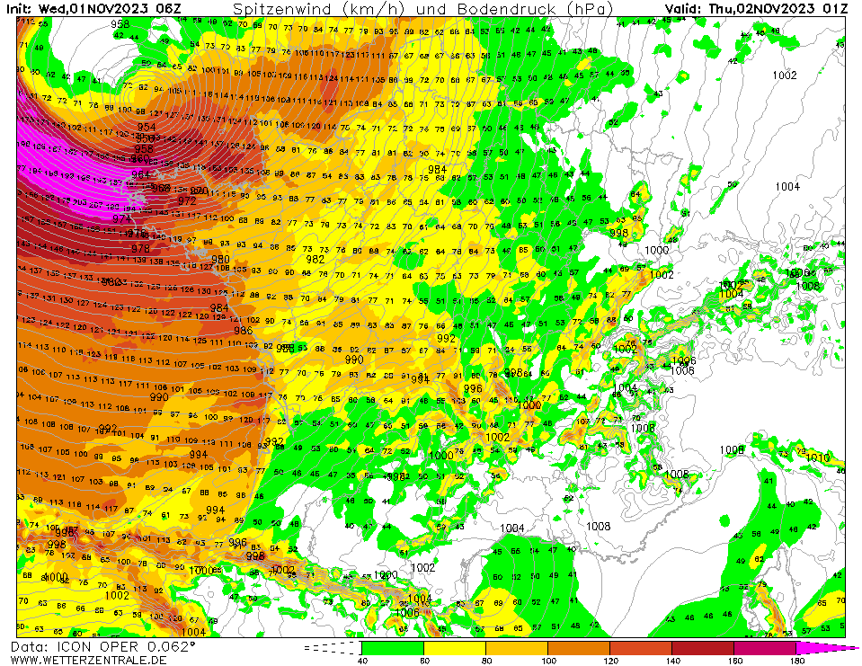
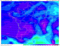
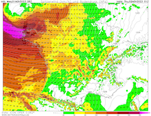
| Peak wind gusts over France,
03.11 21 UTC
Source: wetterzentrale
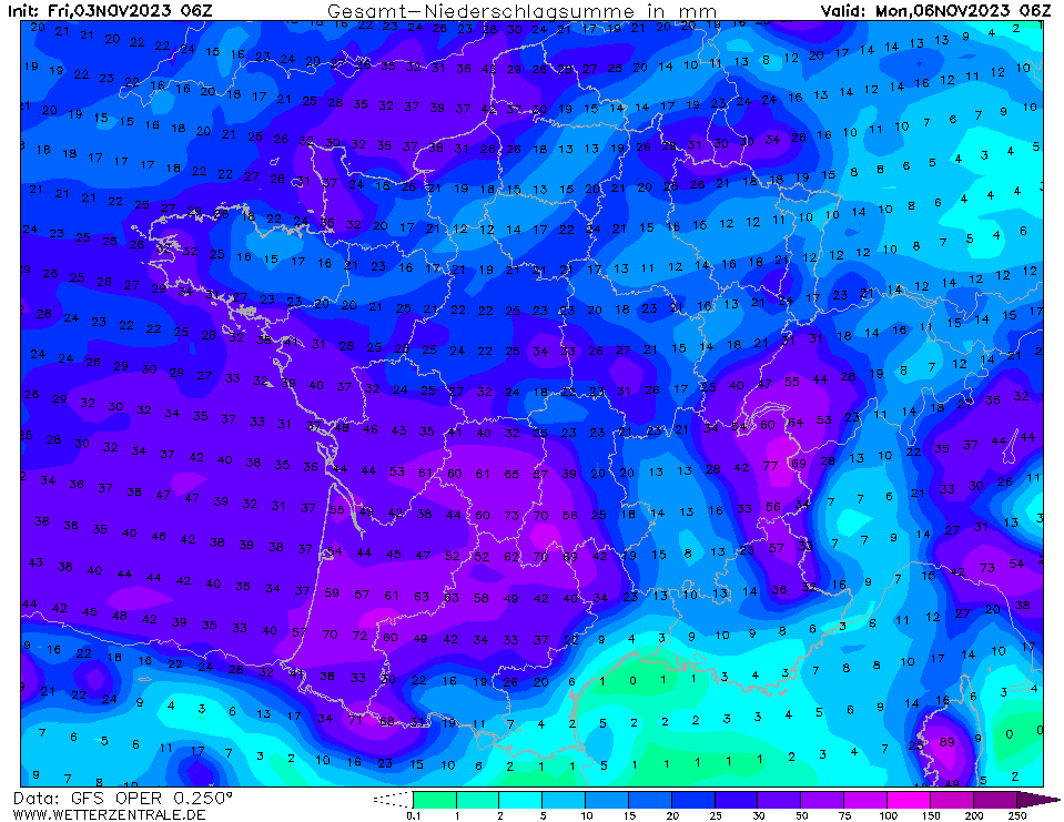
| Accumulated precipitation over France,
until 06.11 06 UTC
Source: wetterzentrale
|
Wind storm
Western Europe
Issued: Friday, November 03, 2023, 15:00 UTC
After Storm Ciarán brought wind gusts of up to 207 kph at Pointe du Raz in Brittany, another powerful windstorm is moving rapidly across the Northern Atlantic and is expected to impact France and the Iberian Peninsula on November 04, 2023, with wind gusts of up to 120 kph.
03.11.2023
Over the Northern Atlantic, two distinct jet streaks are present, combined spanning from Northeastern Canada into Europe. Far south of Iceland, the boundary of the two jet streaks lies. At the surface, a small low-pressure system is moving across the Northern Atlantic, with its center near the boundary region of the two jet streaks. Here, the surface low lies both beneath the left exit and right entry region of the respective jet streaks, creating strong upper-atmospheric divergence, favoring explosive cyclogenesis.
Within a 24 h-period, the core pressure of the cyclone is expected to drop by more than 30 hPa. A core pressure beneath 955 hPa is in the realm of possibilities in the southern part of England in the early morning hours of November 02, 2023. The rapid deepening of the cyclone is enhanced by the favorable positioning of the surface low relative to the jet streak over the Northern Atlantic. The surface low lays beneath the left exit region of the jet streak, where strong upper-atmospheric divergence is present, inducing a middle-tropospheric forcing for lifting.
Though, the surface low lies not directly beneath this region, current model output suggests that the core pressure of the low is not expected to deepen as sharply as Storm Ciarán, only to around 960 hPa. Nevertheless, Storm Domingos is expected to have a strong wind field south of the cyclone center, bringing hurricane-force wind gusts to France and the Northern Iberian Peninsula. Crucially, the brunt of the storm is expected to impact regions of France south of the regions that were already impacted by Storm Ciarán two days prior. The region around Bordeaux is expected to experience wind gusts of up to 100 kph, along the coast wind gusts of up to 120 kph are possible. Over the Bay of Biscay, very rough seas must be expected, with wind gusts reaching up to 150 kph over the open ocean.
In Central Europe, the winds of Storm Domingos will be much weaker, bringing intermittent rain and snowfall to the higher elevations in the Alps. Following Storm Domingos, the very active westerly pattern is expected to calm down.
Wednesday, November 01, 2023, 13:00 UTC
|
|
|
|
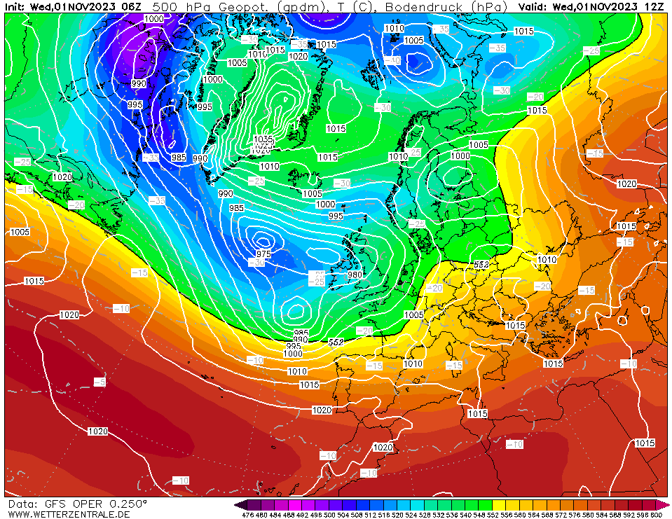
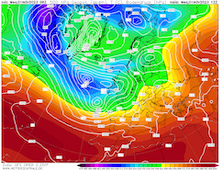
500 hPa Geopotential and sea surface pressure
over Europe, 01.11 12 UTC
Source: wetterzentrale
| 300 hPa Geopotential and wind speeds
along with the 300 hPa divergence
over Europe,
01.11 12 UTC
Source: wetter3
| Peak wind gusts over France,
01.11 01 UTC
Source: wetterzentrale
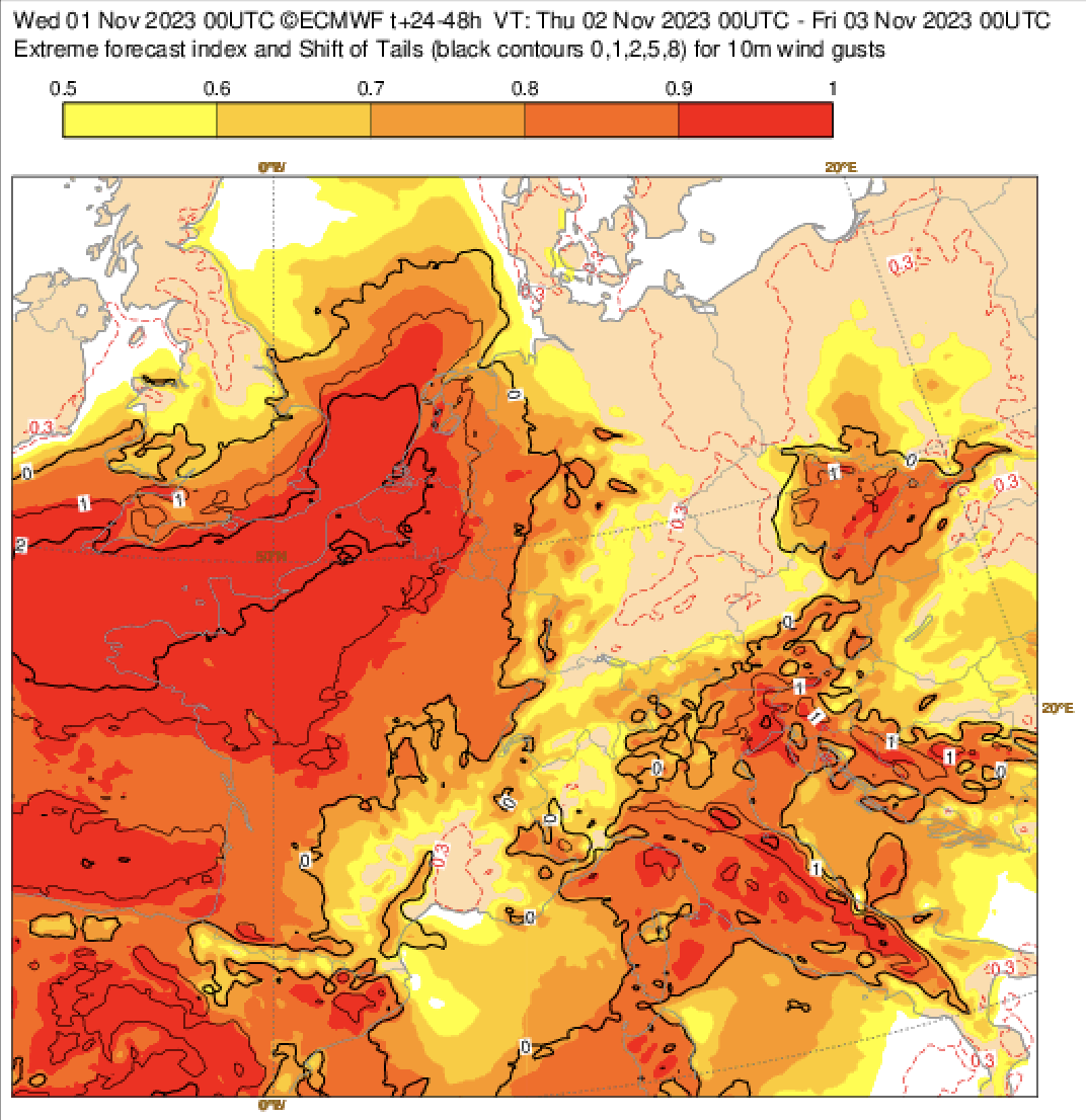
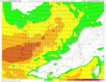
| EFI and Shift of Tails Index
for the 24 h peak wind gusts
over Central Europe,
02.11 - 03.11 00 UTC
Source: ECMWF
|
Wind storm
Western Europe
Issued: Wednesday, November 01, 2023, 13:00 UTC
An extreme windstorm is expected to impact Northern France, with hurricane-force winds and wind gusts of more than 150 kph in exposed locations in the Bretagne and the Normandie in the second half of the night from November 01, 2023, to November 02, 2023.
01.11.2023
On Thursday, November 02, 2023, a powerful extratropical cyclone is expected to impact Western Europe. Current model output shows that a powerful jet streak spanning across the Northern Atlantic is leading to the rapid deepening of cyclone Ciarán. From Northeastern Canada a swell of cold air masses has been advected across the Northern Atlantic, leading to a temperature gradient of up to 20 °C along the polar front in 850 hPa. At the southern flank of the central low-pressure system, a secondary low is deepening currently.
Within a 24 h-period, the core pressure of the cyclone is expected to drop by more than 30 hPa. A core pressure beneath 955 hPa is in the realm of possibilities in the southern part of England in the early morning hours of November 02, 2023. The rapid deepening of the cyclone is enhanced by the favorable positioning of the surface low relative to the jet streak over the Northern Atlantic. The surface low lays beneath the left exit region of the jet streak, where strong upper-atmospheric divergence is present, inducing a middle-tropospheric forcing for lifting.
The center of storm Ciarán is expected to reach Cornwall by midnight. South of the cyclone center, extreme wind speeds must be expected. Over the open ocean, wind gusts of more than 180 kph must be expected, and extreme wind gusts of up to 200 cannot be excluded. Very rough seas are expected to be present over the Eastern Atlantic between Ireland and Spain. Currently, models suggest that the region with the highest wind gusts will be close to the cyclone center and will impact the Brittany directly in the second half of the night from November 01, 2023, to November 02, 2023. Close to the coast, the potential for wind gusts over 160 kph is given. Further inland, hurricane-force wind gusts must be expected. By 03 UTC, the most violent winds will quickly shift across the English Channel, with hurricane-force winds persisting over the Normandie until midday on November 02, 2023.
Depending on the model, parts of Cornwall can also experience hurricane-force winds. Here, the surface pressure will drop to extreme depths, potentially falling below the 955 hPa-mark. The November record for the lowest recorded atmospheric pressure in the United Kingdom is 939.7 hPa on November 11, 1877. Over the British Isles Storm Ciarán is expected to bring heavy rains and snow to the Scottish Highlands. Over Central Europe, the cold front of the system is expected to bring heavy rains and snow to the Southern Alps, with precipitation totals of more than 100 mm and fresh snow accumulations of more than 70 cm until November 04, 2023.
Issued: Wednesday, November 01, 2023, 13:00 UTC
KG
Issued: Friday, November 03, 2023, 15:00 UTC
KG
|