Tuesday, 29 August 2023, 21:00 UTC
|
|
|
|
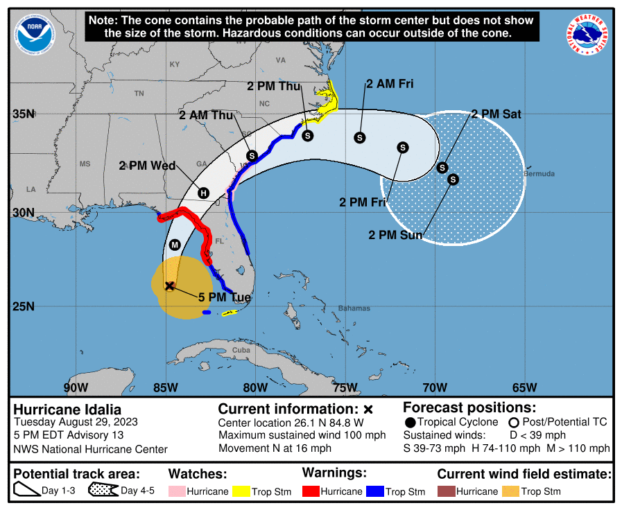
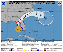
Expected track and strength of Hurricane IDALIA,
29.08 21 UTC
Source: NHC
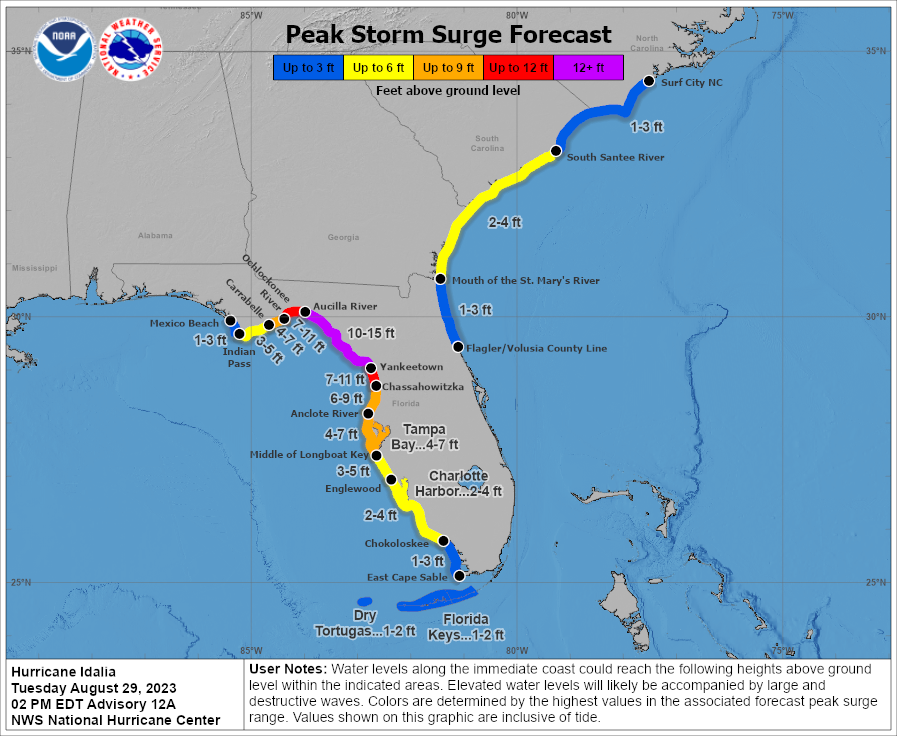
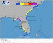
| Expected storm surge along Floridian coast,
29.08 16 UTC
Source: NHC
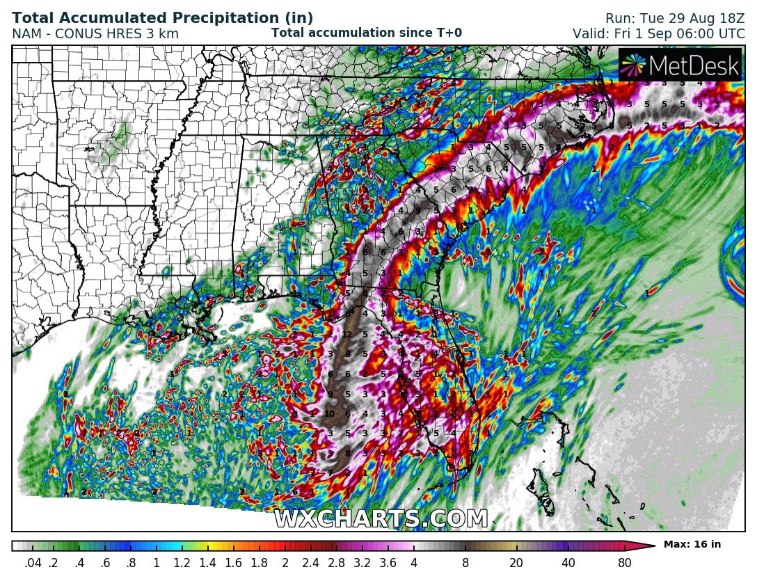
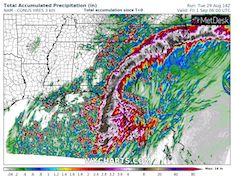
| Accumulated precipitation over the
Southeastern US, unitl 01.09 06 UTC
Source: wxcharts
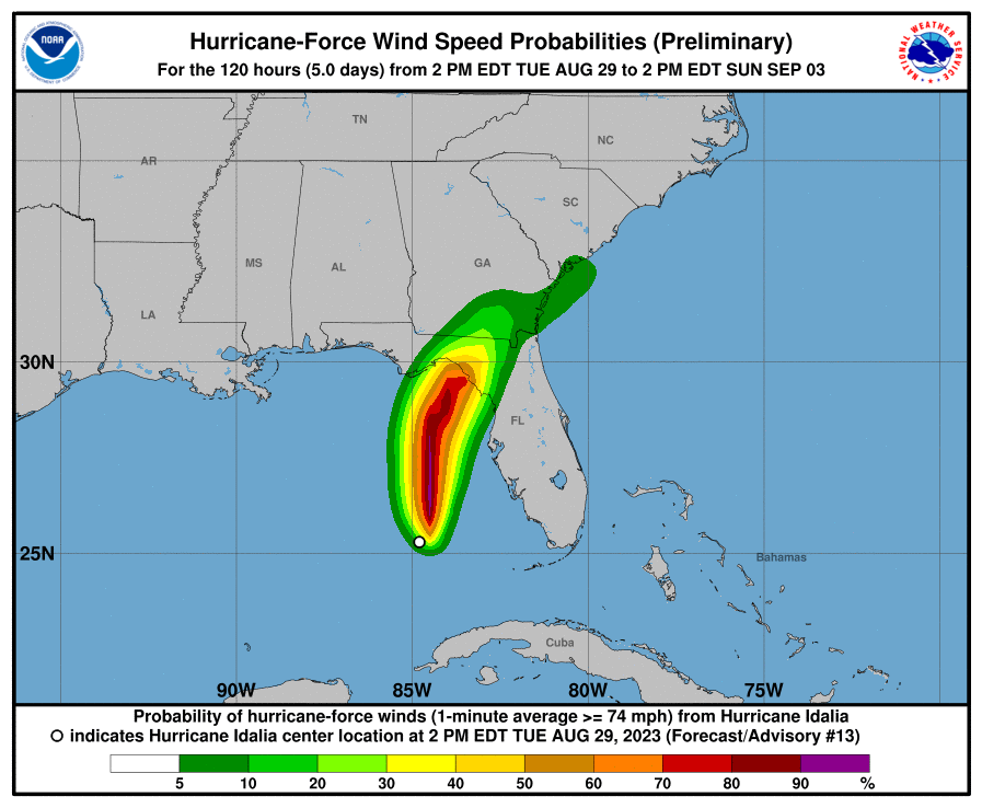
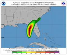
| Possibility for sustained winds reaching
hurricane force, 29.08 16 UTC
Source: NHC
|
Tropical cyclone
Florida, Southeastern US
Issued: Tuesday, 29 Augsut 2023, 21:00 UTC
Less than one year after Hurricane IAN made landfall along the western coast of Florida, near the city of Fort Myers, FL, Hurricane IDALIA is expected to make landfall as a major hurricane north of Tampa, FL in the eastern part of the Florida Panhandle. The expected storm surge in the region is in the same magnitude as observed during the passage of Hurricane IAN.
29.08.2023
The tropical disturbance, which eventually matured into Hurricane IDALIA, formed over the Caribbean Sea off the coast of Honduras on August 25, 2023. In the following days, the system lingered close to the coast nearing the Peninsula de Yucatan, while intensifying slowly into a tropical depression. On August 27, 2023, the system organized further and reached tropical storm strength. By 09 UTC on August 29, 2023, IDALIA has reached hurricane strength, passing west of Cuba into the Gulf of Mexico, causing only minor damage on island of Cuba itself.
Currently, IDALIA is around 210 km northwest of the Dry Tortugas, FL, with sustained winds of 165 kph and wind gusts up to 195 kph. Moving at northwards at 24 kph, the central pressure of the system has dropped to 974 hPa. On its trajectory across the warm waters of the Gulf of Mexico, IDALIA is expected to intensify quickly in the coming hours. Before making landfall before midday local time on August 30, 2023, IDALIA is expected to reach major hurricane status, likely peaking as a strong category 3 hurricane.
IDALIA is currently expected to make landfall in a loosely populated area around 200 km north of Tampa, FL, with sustained winds of up to 200 kph. South of the eye, the main concern will be the severe storm surge of Hurricane IDALIA enhanced by the violent onshore winds. The storm surge is expected to reach between 3 - 5 m along the western coast of Florida between Yankeetown, FL and Aucilla River, FL. Though also in the Tampa Bay, a storm surge of 1.5 - 2.5 m must be expected. North of the eye of the storm, heavier precipitation is expected, with precipitation totals reaching up to 300 mm/48 h, likely causing flash and river flooding. As the storm moves across the southeastern part of the US, the heavy rains will likely spread into the Georgia and the Carolinas.
Issued: August 29, 2023, 21:00 UTC
KG
|