Saturday, 26 August 2023, 11:00 UTC
|
|
|
|
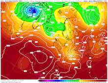
500 hPa Geopotential and sea surface pressure
over Europe, 28.08 12 UTC
Source: wetterzentrale
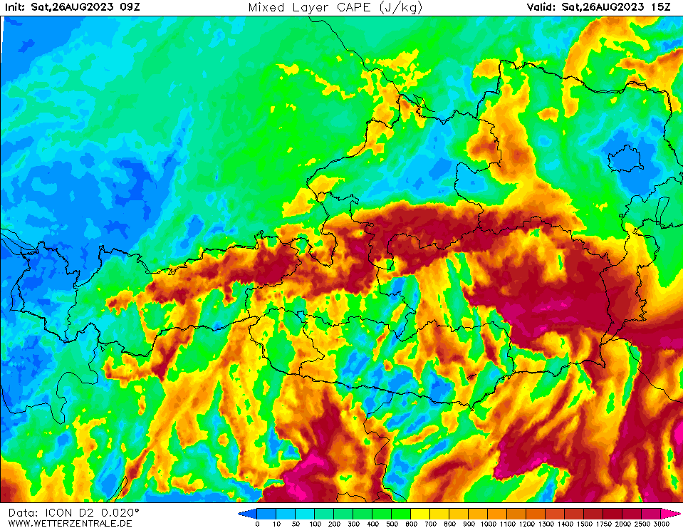
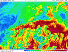
| Mixed-layer CAPE over Austria,
26.08 15 UTC
Source: wetterzentrale
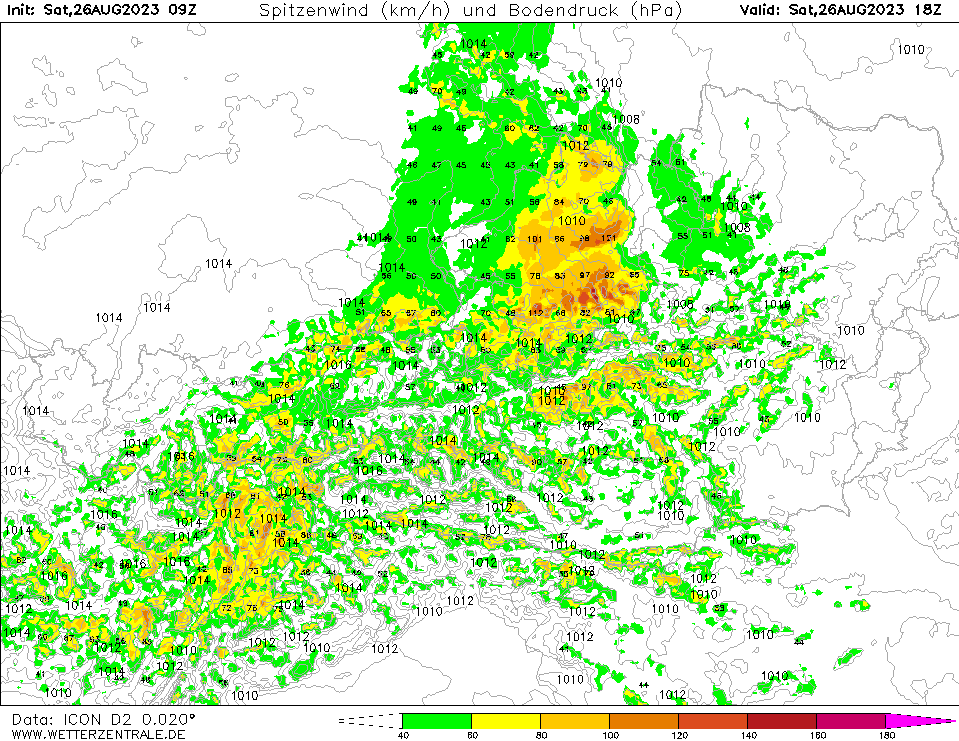
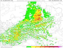
| Peak wind gusts and sea surface pressure
over Austria, 26.08 18 UTC
Source: wetterzentrale
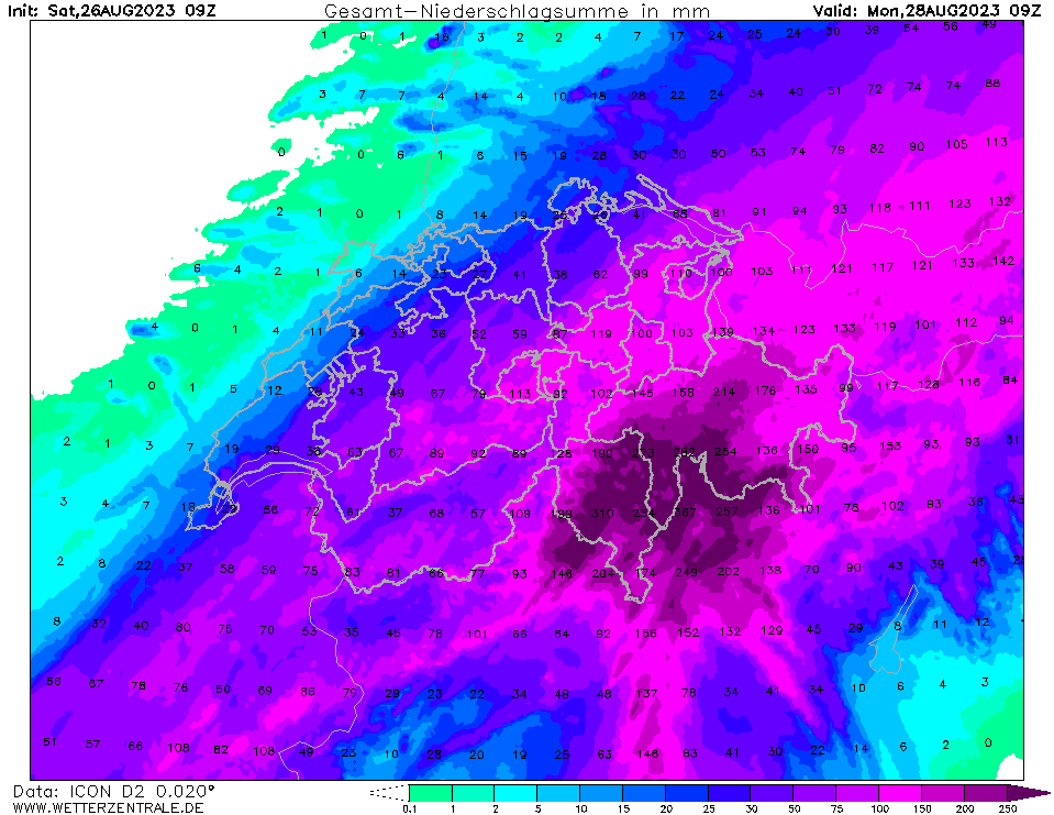
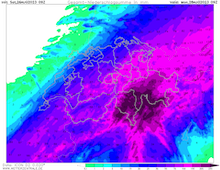
| Accumulated precipitation over Switzerland,
until 28.08 09 UTC
Source: wetterzentrale
|
Heavy precipitation
Central Europe
Issued: Saturday, 26 Augsut 2023, 11:00 UTC
A lee cyclogenesis over the Gulf of Genoa is expected to bring abundant precipitation to the Alpine region until Tuesday, August 29, 2023. Widespread precipitation totals are expected to reach more than 150 mm. Ahead of the continuous rain, severe thunderstorms are expected to form in the afternoon hours of August 26, 2023 in the Alpine foothills of Bavaria.
26.08.2023
After an extended heat wave across the Alps and Southwestern Europe, a trough over the North Sea has become the dominant weather pattern. At the southern tip of the trough, classic lee cyclogenesis is expected over the Gulf of Genoa, accompanied by Mistral winds in the Rh&ocric;ne Valley and the western Mediterranean. The surface low is expected to move slowly northeastwards into the Po Plain. In combination with the upper-level trough, moist and warm air masses from the Mediterranean are advected northwards over the Alps, leading to abundant orographic precipitation.
Ahead of the lee cyclogenesis over the Gulf of Genoa, the nearing trough over the North Sea is expected provide abundant mid-level lifting in the southern part of Bavaria for severe thunderstorms to form in the afternoon hours today, August 26, 2023. Thunderstorms are expected to form an organized squall line moving parallel to the Alps through the Danube Valley. Heavy downpours, violent convective winds of up to 120 kph, and large hail must be expected. e hurricane will rapidly weaken due to the cold waters of the California Current, but still is expected to remain hurricane status upon landfall.
In the Southern Alps, intense precipitation is expected to set in early on August 27, 2023. Highest precipitation totals are expected in the Swiss Canton of Ticino. Within a 48 h-period, precipitation totals of up to 400 mm must be expected, with embedded thunderstorms bringing heavy downpours with hourly precipitation rates of more than 40 mm. As the surface low moves into the Po Plain, the rain is expected to spread across the Alps, spreading into Tyrol and Bavaria. Here, especially in the direct vicinity of the Alps, precipitation totals are expected to reach 100 - 150 mm/48 h. Further north in Bavaria, precipitation totals decrease to 50 - 75 mm/48 h.
As a result of the intense precipitation, small stream flooding and landslides throughout the Alps must be expected, especially in the Swiss Canton of Ticino. Along the major rivers within the Alps, significant river flooding cannot be excluded, most likely effecting the Inn and Alpine Rhine. A large uncertainty remains, concerning the dropping snow line as trough moves over Germany on August 28, 2023. Depending on the model, the snow line can drop rather quickly beneath 2500 m, dampening the excepted run-off especially in Switzerland. Along the Inn, river flooding is likely spreading downstream. In Southern Bavaria, river flooding along the Isar is likely, though no significant high water along the Danube is expected. Along the Rhine, no high water is expected downstream of Lake Constance, with water levels in the Rhine rising moderately.
Issued: August 26, 2023, 11:00 UTC
KG
|