Friday, 18 August 2023, 22:00 UTC
|

|
|
|
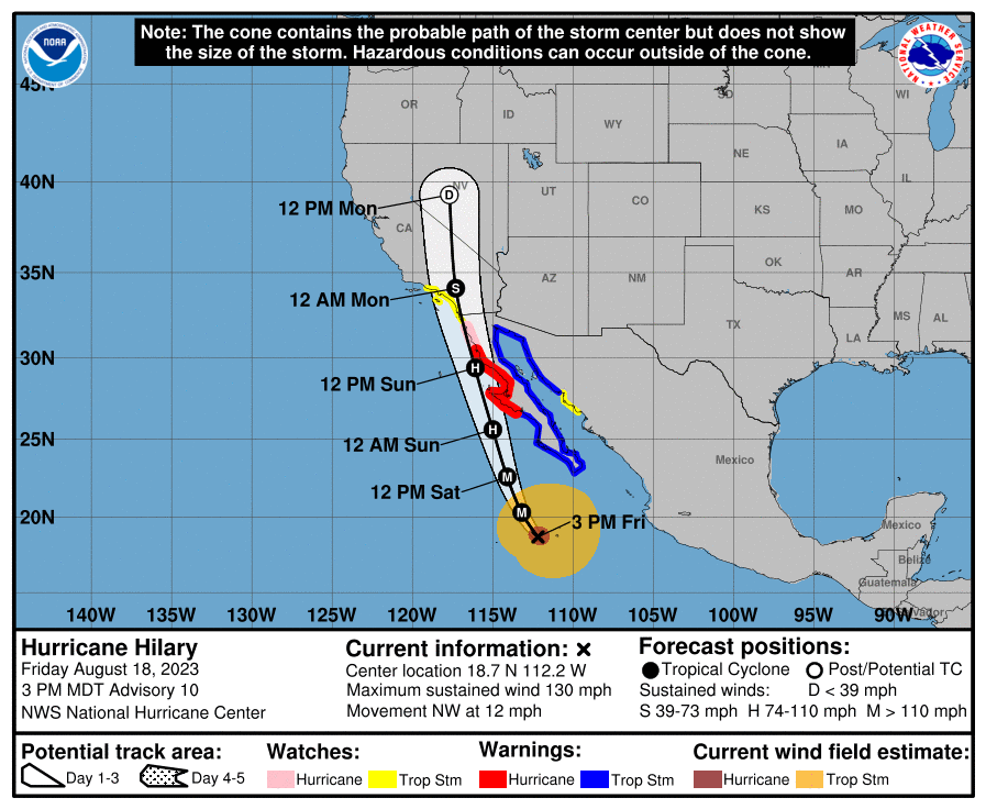
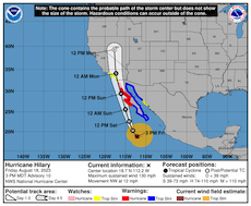
3-day forecast of the track and intensity of Hurricane HILARY,
18.08 21 UTC
Source: NHC
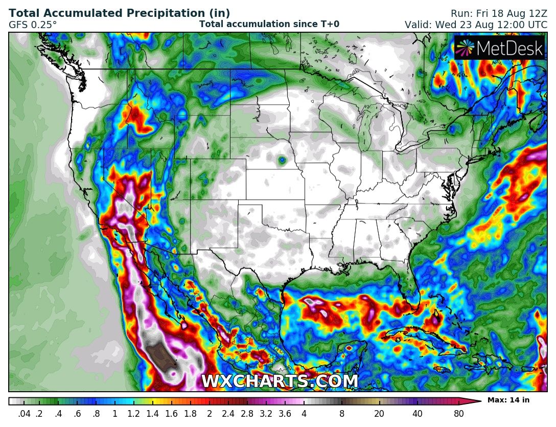
| Accumulated precipitation over Southwestern US,
until 23.08 12 UTC
Source: wxcharts
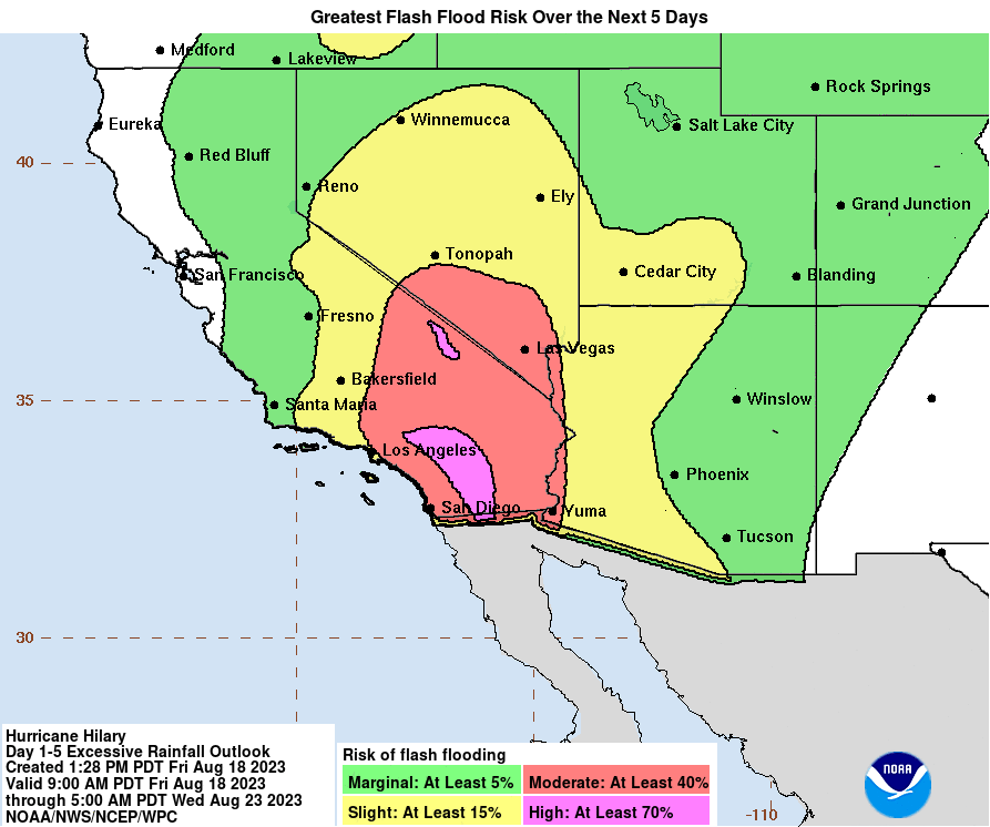
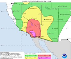
| 5-day flash flooding over Southwestern US,
18.08 15 UTC
Source: NHC
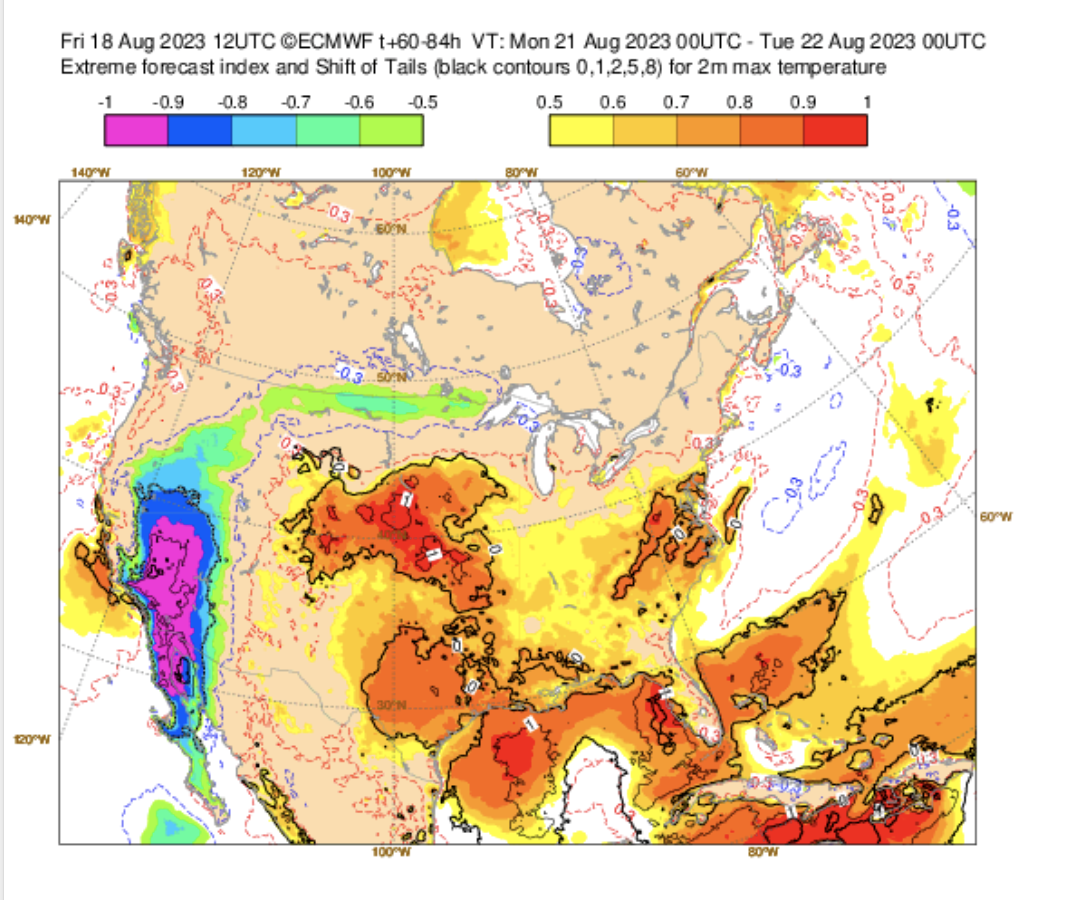
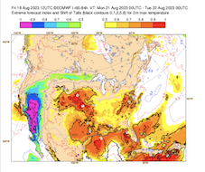
| EFI of 2 m maximum temperature over Northern America,
21.08
Source: ECMWF
|
Tropical cyclone
Mexico, USA
Issued: Friday, 18 Augsut 2023, 22:00 UTC
Hurricane HILARY formed over the Eastern Pacific in the past days, rapidly strengthening into a category 4 hurricane on August 18, 2023, with sustained winds up to 215 kph and a central pressure of 948 hPa. HILARY is expected to make landfall in the northern part of the Baja California on August 20, 2023.
18.08.2023
Hurricane HILARY formed on August 12, 2023, over the Central Eastern Pacific, following the typical track of hurricanes in the Eastern Pacific. Though, an unseasonably strong trough off the coast of Central California led to an unusual track of Hurricane HILARY. Curving more northwards, the hurricane neared the Mexican coast and strengthened rapidly on August 18 and August 19, 2023.
Currently, HILARY reached a category 4 status with sustained winds of up to 215 kph and wind gusts up to 260 kph, with the central pressure dropping to 948 hPa. Now, the hurricane moves with around 19 kph northwestwards and is expected to make landfall in the northern half of the Baja California on August 20, 2023. The exact location of the landfall is difficult to predict as the hurricane moves nearly parallel to the coast of the Baja California. Before landfall, it is expected that the hurricane will rapidly weaken due to the cold waters of the California Current, but still is expected to remain hurricane status upon landfall.
Over the Baja California, HILARY is forecasted to move northwards and gradually weaken, a rare (second) landfall in the vicinity of San Diego, CA cannot be excluded currently. Upon moving into Southern California, HILARY is expected to bring abundant moisture into desert regions of the state. Especially the normally very dry Inland Empire and Imperial Valley will likely receive abundant precipitation. Widespread flash flooding and mudslides along wind gusts of up to 100 must be expected.
Rain totals in the Imperial Valley will likely range between 50 – 100 mm/48 h, which roughly equals 100 – 200 % of the yearly precipitation in this region. El Centro, CA receives around 50 mm of rain annually, with Indio, CA receiving around 75 mm/yr. Heavy rains will likely effect the entire Mojave desert and spread to the metropolitan areas of Las Vegas, NV and Los Angeles, CA. The highest precipitation totals are expected in the San Bernadino mountains with up to 250 mm/48 h. Both river and flash flooding must be expected in the region. Rains will hit the Death Valley, the hottest place on Earth, with expected precipitation totals up to 75 mm/48 h.
The abundant precipitation and high cloud coverage will also lead to extreme cold in Southern California, with day-time high temperature close to the 25 °C-mark, temperatures normally expected in this region in late October and early March. The EFI value in large parts of Southern California is forecasted to be -0.99. Above 3500 m snow must be expected in the southern part of the Sierra Nevada on August 21, 2023.
Issued: August 18, 2023, 22:00 UTC
KG
|