Friday 13 July 2019, 23:30 CET
|

|
|
|
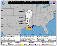
BARRYs trajectory, 13.07.
Image Credit: NOAA
|
Wind speed probability, 13.07.
Image Credit: NOAA
|
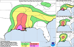
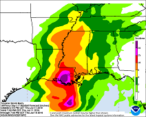
Flash Flood risk (3 days maximum), 16.07., 12 UTC
Image Credit: NOAA
|
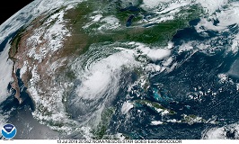
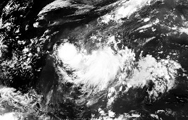
Satellite image, 13.07., 21 UTC
Image Credit: NOAA
|
Tropical cyclone
USA, Louisiana, Texas, Arkansas, Mississippi
Issued: Friday, 13 July 2019, 23:30 CET
BARRY made Landfall near Intracoastal City, Louisiana, as a Category 1 Hurricane. There
is a threat of storm Surge, severe rainfalls up to 600mm and winds up to 115 kph.
11-16 July 2019
BARRY became a Category Hurricane on Saturday 15 UTC as its maximum mean winds exceeded 119 kph. Only two hours later, on 17 UTC, BARRY made Landfall
near Intracoastal City, Louisiana, and quickly weakened to tropical storm again. On Saturday evening, his displacement direction turned to northwest,
before changing to a northern direction in the night of Sunday.
The maximum expected wind speeds are 115 kph and even higher in gusts. Hurricane-force winds extend outward up to 75 km to the east of the center and tropical-storm-force
winds extend outward up to 280 km from the center. The weather station in Eugene Island, Louisiana, reported average wind speeds of 100 kph and gusts of 132 kph at 15 UTC.
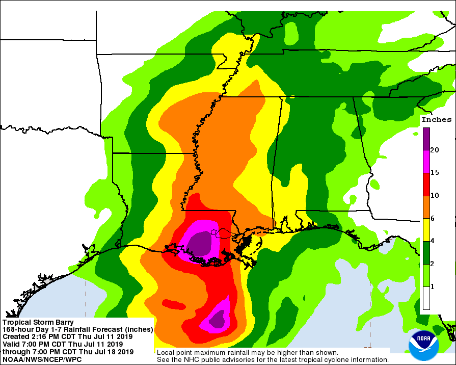
BARRY will provide total precipitation amounts of 300 to 500 mm over south-central and southeast Louisiana and southwest Mississippi. Locally precipitation values can be up to 600mm.
Further inland, in the lower Mississippi Valley and western parts of the Tennessee Valley, total precipitation of 150 to 200 mm is expected, locally up to 300 mm.
This will lead to life-threatening flooding.
Friday 12 July 2019, 20:15 CET
|
|

|
|
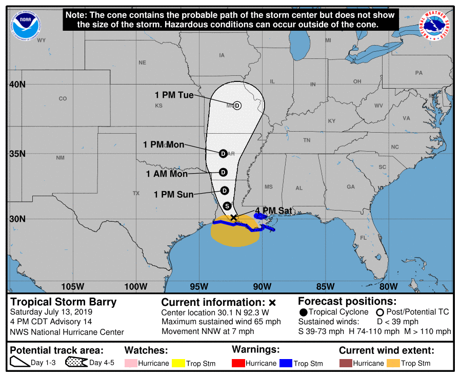
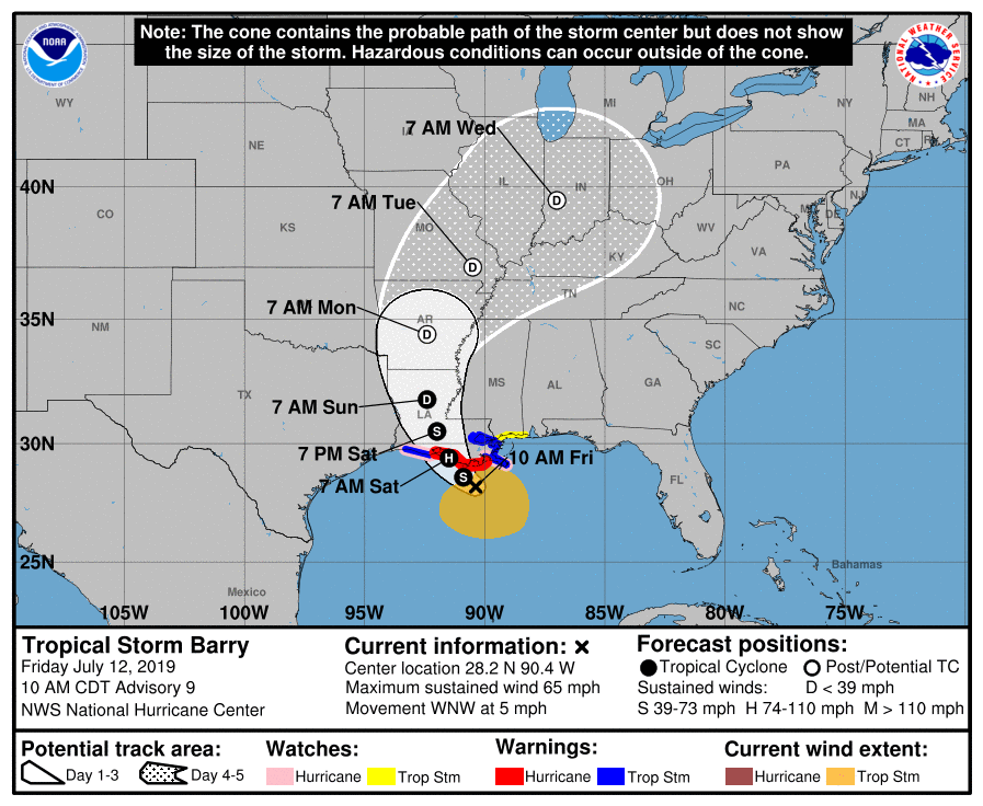
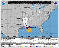
BARRYs trajectory, 12.07.
Image Credit: NOAA
|
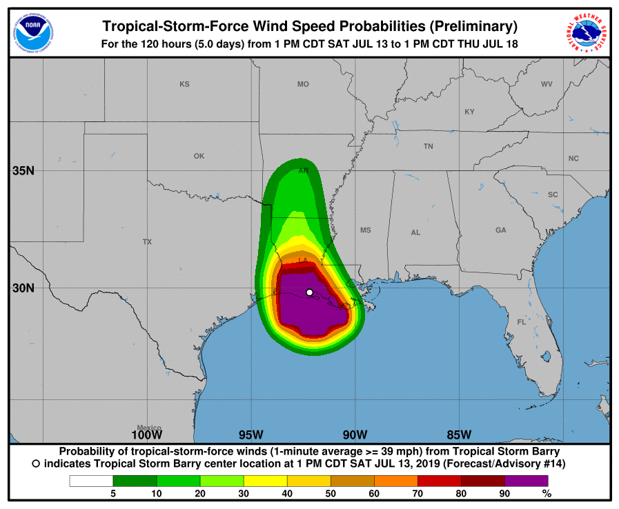
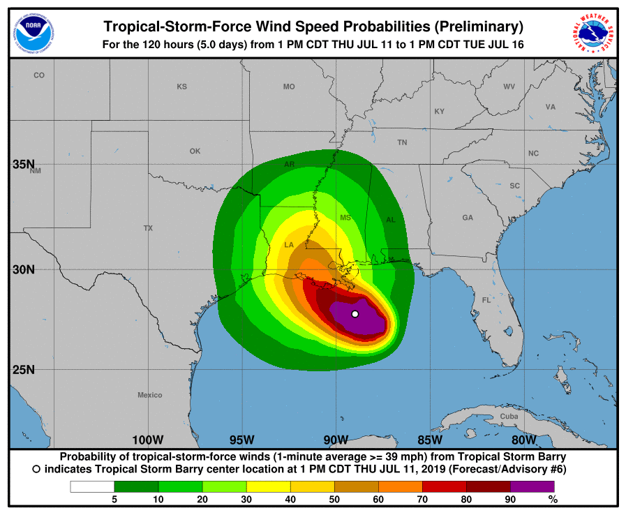
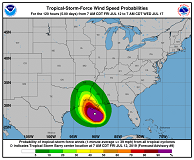
Wind speed probability, 12.07.
Image Credit: NOAA
|
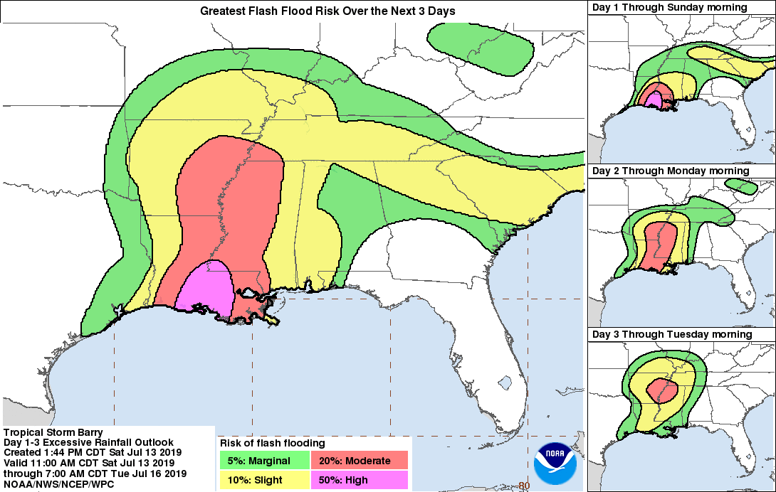
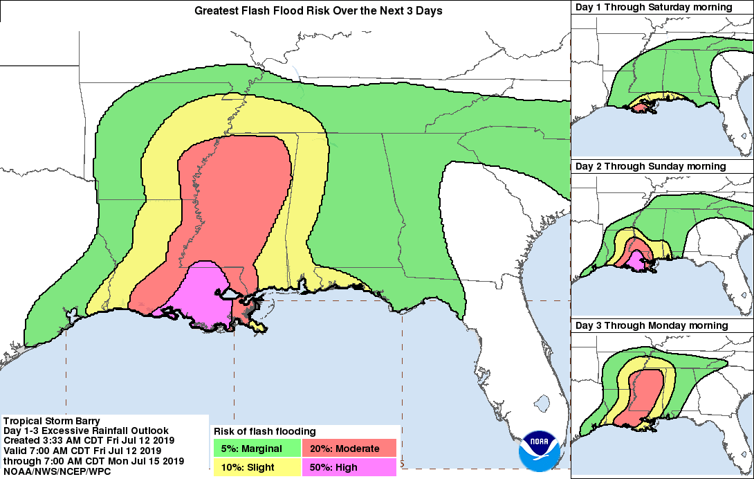
Flash Flood risk (3 days maximum), 15.07., 12 UTC
Image Credit: NOAA
|
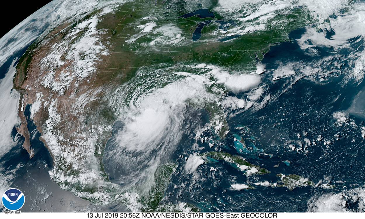
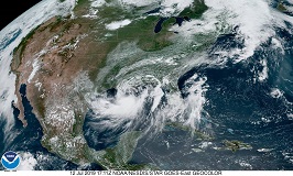
Satellite image, 12.07., 17 UTC
Image Credit: NOAA
|
Tropical cyclone
USA, Louisiana, Texas, Arkansas, Mississippi
Issued: Friday, 12 July 2019, 20:15 CET
Tropical storm BARRY is currently located 160 km south-southeast of Morgan City and is expected to make landfallas Category 1 hurricane
on Saturday at 12 UTC in Louisiana. Wind speeds of up to 130 kph and total precipitation of 500 mm are expected.
11-16 July 2019
BARRY is currently located 160 km south-southeast of Morgan City and is moving west-northwest at 7 kph. On Friday at 18 UTC it has average wind speeds of 100 kph.
The tropical storm is expected to intensify further on its way to the coast and to make landfall as a Category 1 hurricane in Morgan City, Louisiana.
On the coastline of Louisiana hurricane-like conditions are expected. Tropical storm conditions are also expected in the interior of Louisiana and in
the bordering areas of the surrounding federal states.
Along the coast of Louisiana there is danger from life-threatening storm surges. Parts of Lake Pontchartrain and coastal areas of Mississippi are also threatened by storm surges. Water
levels are already beginning to rise in affected areas. The highest levels are expected on Saturday at 18 UTC between Intracoustal City and Shell Beach, Louisiana.
The slow displacement speed of the tropical storm results in long-lasting rainfall and enormous amounts of precipitation.
Along the central Gulf coast, the lower Mississippi Valley and the Tennessee Valley, severe rainfall of up to 500 mm is expected, which can lead to flooding.
In southeastern Louisiana and parts of Mississippi, flash floods and river floods are expected to be life-threatening.
Friday 12 July 2019, 00:15 CET

|
|
|
|
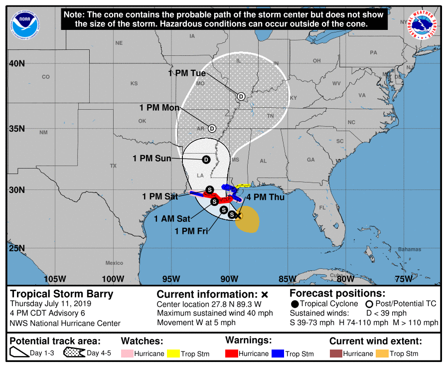
BARRYs trajectory, 11.07.
Image Credit: NOAA
|
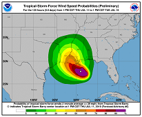
Wind speed probability, 11.07.
Image Credit: NOAA
|
Accumulated precipitation, 11.07., 12 UTC
Image Credit: NOAA
|
Satellite image, 11.07., 18 UTC
Image Credit: Dundee Satellite Recieving Station
|
Tropical cyclone
USA, Louisiana, Texas, Arkansas, Mississippi
Issued: Friday, 12 July 2019, 00:15 CET
Tropical Cyclone BARRY is the first hurricane in the North Atlantic to kick off the 2019 hurricane season. At 21 UTC it
is located 280 km southeast of Morgan City (Louisiana) and has average wind speeds of 65 kph.
11-16 July 2019
Tropical cyclone BARRY is currently located 280 km southeast of Morgan City (Louisiana) and is shifting slowly at 7 kph
to the west. Due to the high water temperatures in the Gulf of Mexico of more than 30°C, the tropical storm will intensify
until land fall. After the storm changes its trajectory northwards, it is expected to hit Morgan City on Saturday at 12 UTC.
Average wind speeds of up to 90 kph are expected in coastal areas. The main threat of the tropical cyclone does not result
from the wind speeds, but further from the precipitation amounts.
Total precipitation of more than 500 mm is estimated in the state of Louisiana. There is a risk of flooding and landslides in Louisiana, but also in eastern Texas, southern Arkansas and western Mississippi.
Furthermore, due to southeastern winds a storm surge is likely at Lake Pontchartrain.
Issued: July 12, 2019, 00:15 CET
FS
Issued: July 12, 2019, 20:15 CET
FS
Issued: July 13, 2019, 23:30 CET
FS
|