Monday, 14 January 2019, 09:30 CET
Heavy snowfall - Warning
Central Europe (Northern Alps, Bavarian Forest, Black Forest, Ore Mountains)
Issued: Monday, 14 January 2019, 09:30 CET
Snow amounts up to 50 cm/24h at higher elevations of the Northern Alps, especially in the Swiss Alps.
Buildings and trees may collapse under enormous snow weight. Situation will get more critical due to additional rain.
Risk of avalanches.
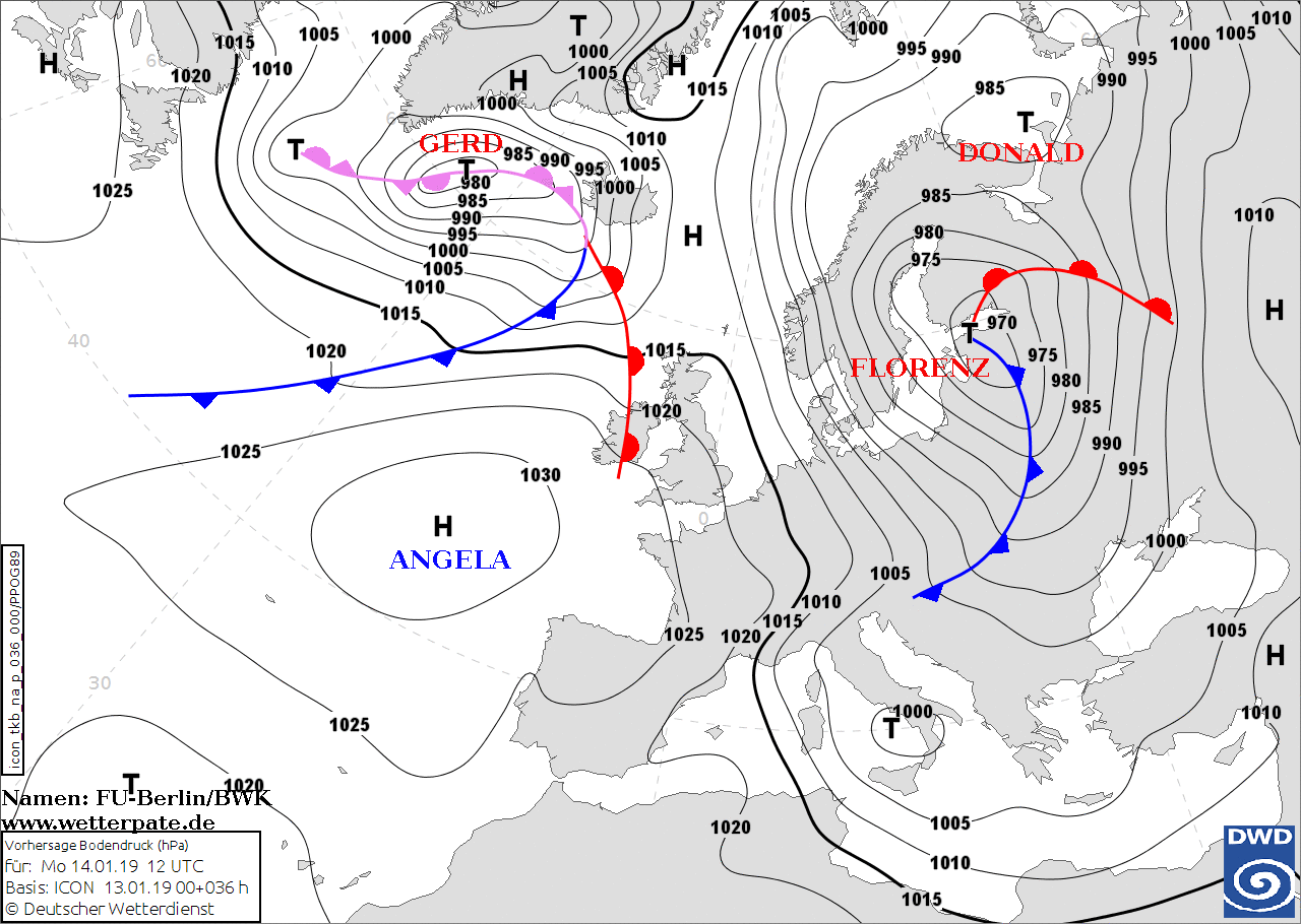
07-14 January 2019
Between high ANGELA over the Eastern Atlantic and low FLORENCE over the Gulf of Finland,
cold air has returned to Germany with a northwestern high-altitude current. Due to the unstable stratified air mass,
very windy rain weather is occurring throughout the country, and thunderstorms cannot be ruled out.
The warm front of low GERD near Iceland reaches Central Europe today and moves rapidly further east.
In the course of the day, temporary precipitation occurs in the incoming wet and cold polar air,
which turns into snow from 300 to 500 metres. Snowfall continues in the Alps, where up to 50 cm of
fresh snow can be expected. However, precipitation also subsides in the Alps towards evening.
Since the pressure difference between the low FLORENCE and high ANGELA is large and the pressure gradient
is correspondingly large, the wind freshens up today and tomorrow and storm gusts are possible in the mountains.
There is also the danger of avalanches and snow breakage. In Lech am Arlberg in Austria and in Balderschwang
(Bavaria) the places are cut off from the outside world due to the high avalanche danger.
Sunday, 13 January 2019, 11:45 CET
Heavy snowfall - Warning
Central Europe (Northern Alps, Bavarian Forest, Black Forest, Ore Mountains)
Issued: Sunday, 13 January 2019, 11:45 CET
Snow amounts up to 100 cm/48h at higher elevations of the Northern Alps, especially in the Swiss Alps.
Buildings and trees may collapse under enormous snow weight. Situation will get more critical due to additional rain.
Risk of avalanches.
07-14 January 2019
On sunday, maritime polar air continues to flow onto Central Europe in the back of low-pressure area EUGEN, causing further snowfalls.
In the course of Sunday, the warm air sector of the subsequent low pressure area FLORENZ reaches Central Europe.
In this process the snow line rises to over 1000 m. Additional rainfall may increase the risk of avalanches dramatically.
The much colder air mass in the wake of FLORENZ, arriving Central Europa on Monday, turns rain into snowfall again at all levels.
Due to the northwestern inflow, the most intense snowfalls occur in Switzerland. Until 15.01. 00 UTC accumulated fresh snow amounts may exceed 100 cm.
In the Bavarian and Austrian Alps up to 70 cm fresh snow are possible in the same period.
At exposed locations strong wind gusts >80 kph also cause large snow drifts.
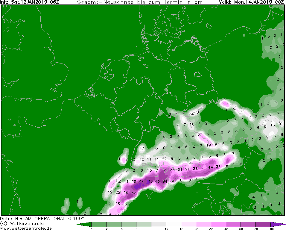
Saturday, 12 January 2019, 12:00 CET
Heavy snowfall - Warning
Central Europe (Northern Alps, Bavarian Forest, Black Forest, Ore Mountains)
Issued: Saturday, 12 January 2019, 12:00 CET
Snow amounts up to 100cm/48h at higher elevations of the Northern Alps; 40cm/48h at summit areas of German Uplands.
Danger of collapsing houses and trees due to enormous weight of snow and additional rain.
Risk of avalanches and snow drifts.
07-14 January 2019
On Saturday low pressure areas EUGEN and DONALD transport maritime air of polar origin from the northwest to Central Europe.
The associated frontal systems of EUGEN cross Germany in the course of Saturday. They lead to rain in the lowlands and snow above 600m, on
Sunday, 13 Jan 2019, rain will occur at least below 1000 m.
While on Sunday, DONALD and EUGEN will be located over north eastern Europe alreday, the next low pressure system
FLORENZ again establishes a flow of maritime air masses, that will be pretty warm at first causing rain
at elevations below at least 1000m on Sunday.
In the wake of EUGEN's cold front much colder air enters central Europe from Monday onwards turning rain into snow again at all levels.
As the inflow of air has shifted to westerly or northwesterly directions, the highest quantities of fresh snow will occur rather in Switzerland than in Austria oder Bavaria.
Locally, fresh snow amounts may exceed 100 cm within 48 h (until 14 Jan 2019). At exposed locations strong wind gusts >100 kph also causes large snow drifts. As
the risk of avalanche danger has reduced slightly on Saturday, it will increase again due to the new snow and rainfall on Sunday and Monday
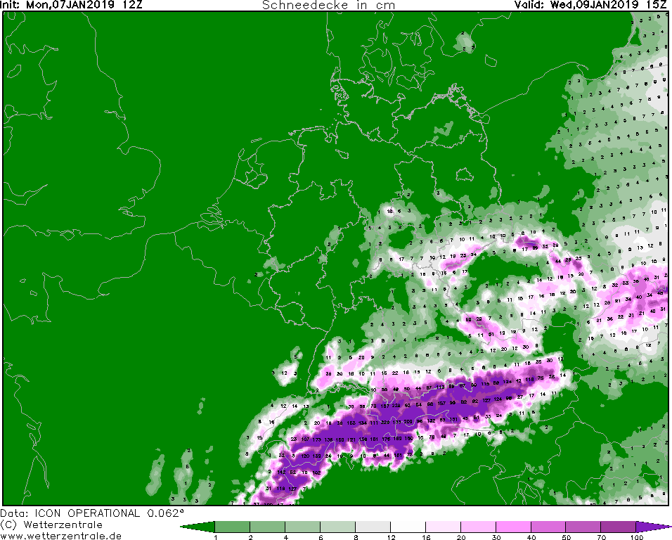
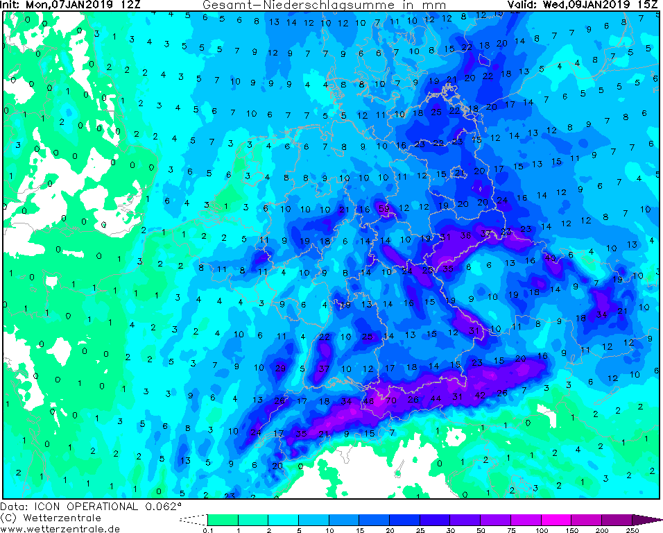
Thursday, 10 January 2019, 11:45 CET
Winterstorm / heavy snowfall - Warning
Central Europe (North Sea, Baltic Sea, Central German Uplands, Alps)
Issued: Thursday, 10 January 2019, 11:45 CET
In the east and the south of Germany, especially on the north side of the Ore Mountains and the Alps, there is hazard from collapsing
buildings or trees due to new snow amounts of up to 50 cm/24h. Restrictions in rail and road traffic have to be taken into account.
07-10 January 2019
Today the extensive low pressure system of CHRISTOF is located between southern Italy and Greece.
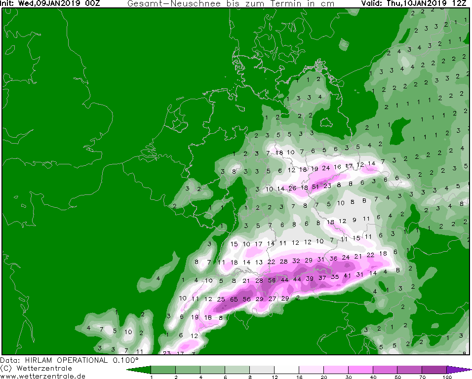
The humid cold polar air continues to flow into Central Europe. As a result, heavy snowfalls continue to occur
at the northern Alpine congestion. New snow quantities of up to 100 cm are expected by Friday evening. Due to the
persistent snowfalls, there is still a high risk of avalanches, and there may also be disruptions in railway network
and on the roads. Roofs of buildings can also collapse due to the snow weight. In the further part of the day,
Germany is temporarily affected by the constant high pressure system of ANGELA, which leads to a calming of the weather.
Because of the constant high pressure, low pressure areas have to make a large curve around this high pressure system,
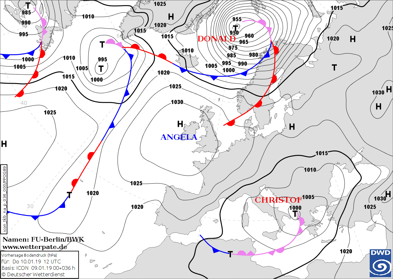
the new storm low DONALD can be found over the northern North Sea.
Its warm front is approaching Denmark from the North Sea this evening.
Tomorrow DONALD continues his trek to the east and the warm front crosses the northwestern half of
Germany in the course of the day. Milder air flows in from the North Sea at higher altitudes, but the
cold air remains close to the ground. This is why precipitation occurs in the transition zone, which
can occur in all aggregation conditions. From snow, sleet, ice grains to freezing rain with ice formation,
anything is possible in some areas. At the Alps the precipitation accumulates and new heavy snowfalls are
expected at the weekend.
Wednesday, 09 January 2019, 11:30 CET
|
|
|
|
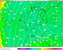
Surface pressure, 10.01., 12 UTC
Image Credit: DWD/FU-Berlin
|
850hPa-Temperature, 09.01., 12 UTC
Image Credit: Wetterzentrale
|
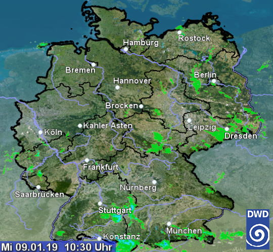
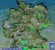
Rain radar, 09.01., 09:30 UTC
Image Credit: DWD
|
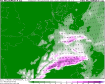
New Snow amount, 10.01., 12 UTC
Image Credit: Wetterzentrale
|
Winterstorm / heavy snowfall - Warning
Central Europe (North Sea, Baltic Sea, Central German Uplands, Alps)
Issued: Wednesday, 09 January 2019, 11:30 CET
Also on Wednesday there is still danger from wind and storm gusts on the coasts of the North and Baltic Sea as well as in exposed areas.
In the east and the south of Germany, especially on the north side of the Ore Mountains and the Alps, there is hazard from collapsing
buildings or trees due to new snow amounts of up to 50 cm/24h. Restrictions in rail and road traffic have to be taken into account.
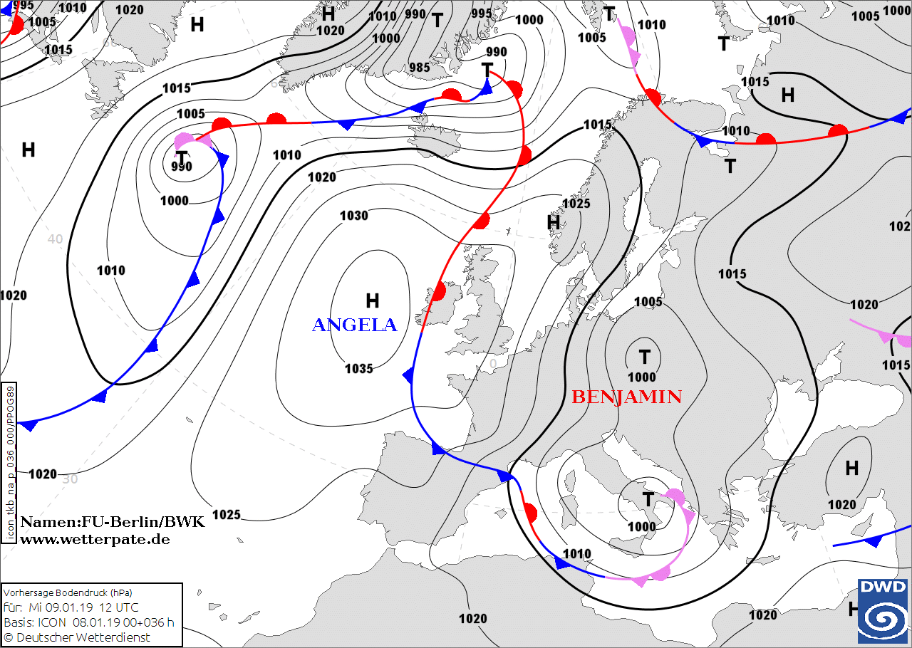
07-10 January 2019
While the storm surge in Hamburg has subsided, the German Baltic Sea coast still is threatened by a flood event. The winds, which are
from northerly or north easterly directions, are squeezing the Baltic Sea water onshore. There is already flooding in parts of the old town of
Lübeck. Water levels of 1.40 m above the mean water level are expected.
The responsible low pressure system BENJAMIN is weakening and the storm's center will be located over south western Poland by Wednesday noon.
The propagation speed of the low-pressure system has significantly reduced, and Germany stays on the western edge within a northerly flow of cold air.
This flow of cold and humid air masses results in precipitation mostly of shower type and snow even in the lowlands. Particularly on the northern sides of the Ore Mountains
and the Alps accumulation of fresh snow may exceed 50 cm/24h
Until Friday morning, fresh snow amounts of another 50-100 cm have to be taken into account particularly along
the Bavarian and Austrian Alps. Snow drifts and the danger of avalanches may cause additional road closures and difficulties in railway network.
Trees and some infrastructure or buildings may collapse due to heavy snow weight on roofs.
On Friday, Germany will get under the influence of a high pressure ridge approaching from the northwest, and precipitation temporarily is not be a big issue.
Tuesday, 08 January 2019, 22:30 CET
Winterstorm / heavy snowfall - Warning
Central Europe (North Sea, Baltic Sea, Central German Uplands, Alps)
Issued: Tuesday, 08 January 2019, 22:30 CET
Possible damage due to collapsing trees and buildings as a consequence of heavy snow weight.
Snow accumulation around or above 50 cm at higher elevations affecting public transport and causing additional road closures
until Thursday.
At exposed areas massive snow drifts. Risk of avalanches
07-10 January 2019
With strong northwesterly winds, winterstorm BENJAMIN caused rough seas and a storm surge along Germany's North Sea coast line.
The high water level of the Elbe River flooded the Hamburg Fischmarkt.
The responsible low pressure system is weakening and the storm's center will be located
over south western Poland by Wednesday noon.
However, wind gusts may be in the order of 100 kph or above on the crests of the ore Mountains and the Alps until Wednesday noon.
In the wake of BENJAMIN cold air is forced into central Europe turning precitation into snow even in the lowlands.
Until Thursday, fresh snow amounts of another 50-100 cm have to be taken into account particularly along
the Bavarian and Austrian Alps. Snow drifts and the danger of avalanches may cause additional road closures.
Trees and some infrastructure or buildings may collapse due to heavy snow weight on roofs.
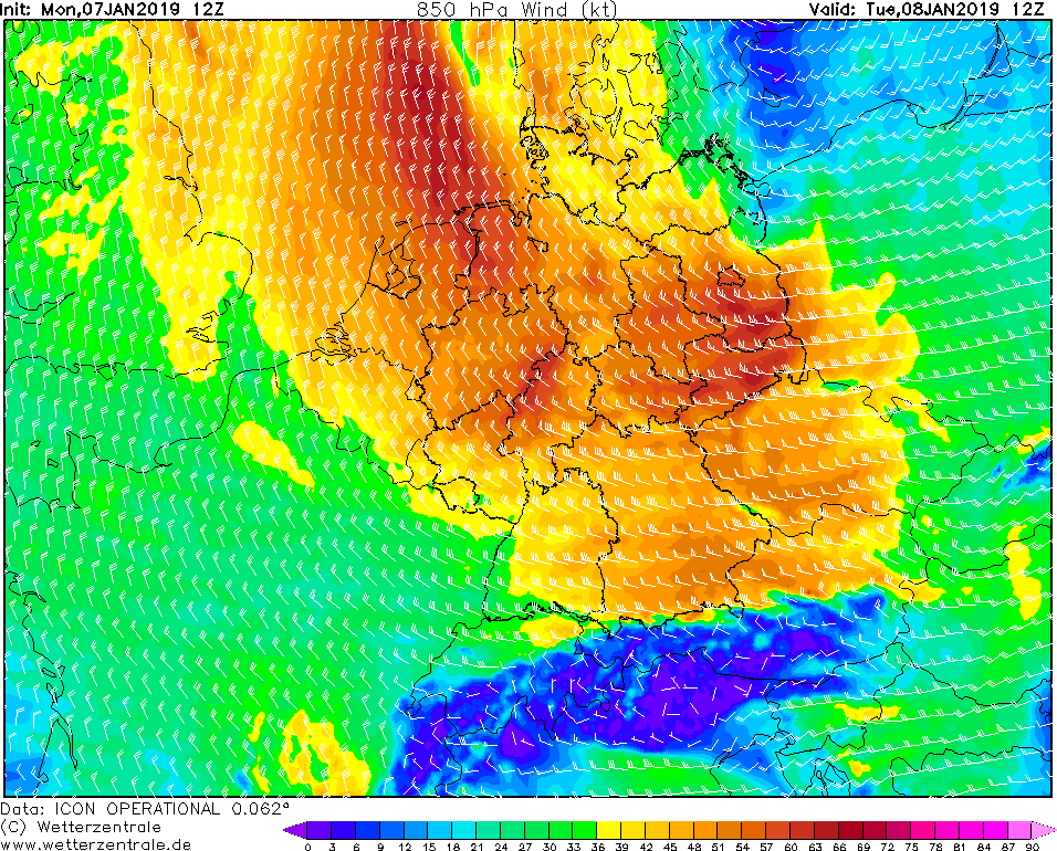
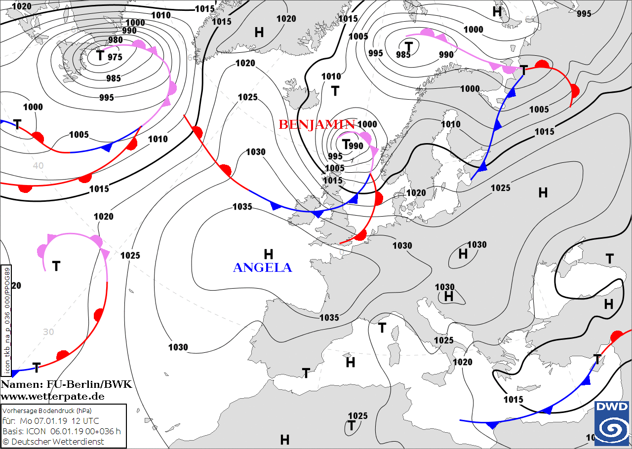
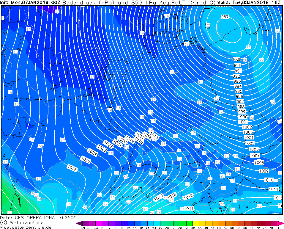
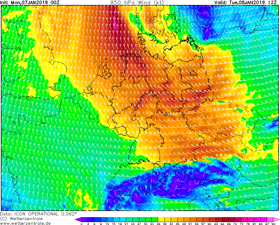
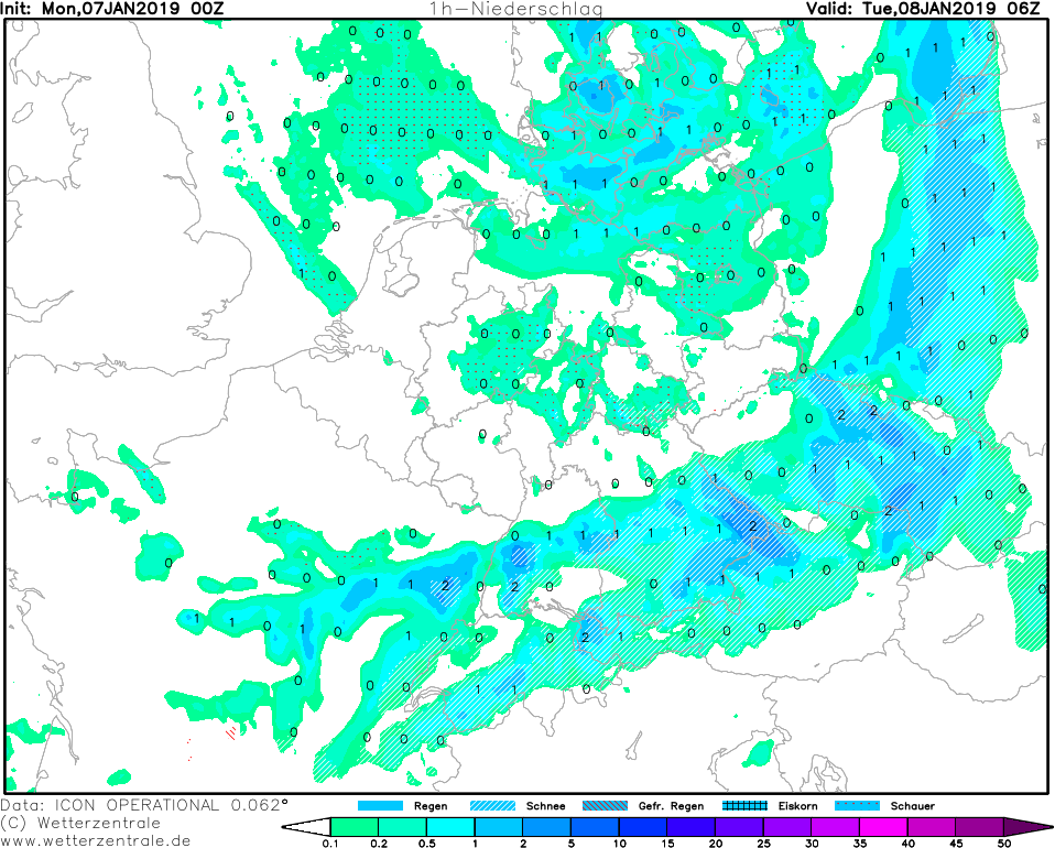
Monday, 07 January 2019, 09:30 CET
Winterstorm - Warning
Central Europe (North Sea, Baltic Sea, Central German Uplands)
Issued: Monday, 07 January 2019, 09:30 CET
Possible damage due to windgusts exceeding 100 kph likely in parts of central Europe. Storm surge along the coastlines of North Sea and Baltic Sea.
Snow accumulation around or above 50 cm at higher elevations affecting public transport during next 48-72 hours.
08 January 2019
The new year starts stormy in the north of Germany. Winterstorm BENJAMIN moves across Denmark and the Baltic Sea on Tuesday morning.
Especially in the northeast it brings storm gusts up to 66 kt (119 km / h). Occasionally, gale gusts can occur, especially on exposed sites.
There is also the danger of a storm surge.
At the moment BENJAMIN is located on the western Atlantic Ocean and Germany and Southwest Europe are influenced by the strong and pronounced high pressure area
ANGELA. Since this extends across the Bay of Biscay far to the west and to the north to Ireland, BENJAMIN is distracted over the North Atlantic before he will
reach Germany on Tuesday morning. It moves from the northwest over the North Sea to Denmark to the southeast, later south over the Baltic Sea and Eastern Europe.
The center will not reach Germany after the current model runs. However, his fronts will reach the northeast of Germany on Monday night. Its development is favored
by its location in the jet stream, due to the region of positive divergence on the left jet exit.
As soon as BENJAMIN has reached the Baltic Sea, it will only slowly relocate, which is expected to be the case on Tuesday evening. Its core pressure is around
987 hPa and starts to rise slowly during the night to Wednesday. The main storm field extends mainly over the northeast of Germany, over Lower Saxony and Bremen.
By the evening this moves to Thuringia and Saxony, as well as to Saxony-Anhalt. The strong winds develop due to the increasing pressure gradient. On the coasts may
be a storm surge.
Due to the adjoining north wind and warm fronts backlog at the Alps, there are again congestion effects in the Alps.
It must be expected with increased rainfall in the form of snow or rain. In the rest of the country, especially in the middle, shower must be expected, wehre also
squalls can occur. On the south side of the Alps, the temperatures rise through foehn effects in the mild area.
BENJAMIN slowly moves south on Wednesday, while moving across Poland and the Czech Republic. The pressure increases slowly and the winds weaken.
Issued: Jan 07, 2019, 09:30 CET
MG
Issued: Jan 08, 2019, 22:30 CET
BM
Issued: Jan 09, 2019, 11:30 CET
FS
Issued: Jan 10, 2019, 11:45 CET
CL
Issued: Jan 12, 2019, 12:00 CET
FS
Issued: Jan 13, 2019, 11:45 CET
FS
Issued: Jan 14, 2019, 09:30 CET
CL
|