Windcharts
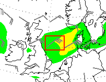
Wind charts show the mean wind speed at a height of 10 meters above ground.
The direction and strength of the wind are indicated by a wind arrow,
colored areas emphasize the areas with particularly high wind speeds.
Colors:
- green: > 40 km/h
- yellow: > 60 km/h
- orange: > 80 km/h
- red: > 100 km/h
In aviation and sea fare wind speeds are given in knots. Also on weather maps, the unit "kt" is usually used for wind speed information.
One knot (kt) equals eon nautic mile per hour, ein nautic mile is 1.852 km.
- 1 kt = 1.852 kph = 0.51 m/s
- 1 kph = 0.54 kt = 0.28 m/s
- 1 m/s = 3.6 kph = 1.94 kt
Example:
In the map above, the wind symbol over the North Sea marks a northeasterly wind blowing at an average of 30 kts. A little further north, the wind blows with 15 kts from the northeast.
From wind charts, the wind fields of low pressure areas can often be tracked well over several days; they can extend over several 100,000 km⊃2; and are sometimes well pronounced over sea. Inland, mean wind speeds are much lower due to friction. Wind gusts are higher but can only be estimated; gustiness depends on the upper level winds and the stratification of the atmosphere.
Along ths shorelines and over open sea the highest wind speeds occur in the vicinity of extra-tropical low pressure systems or tropical cyclones. Inland, gusts in association with thunderstorms can cause greater damage in summer than winter storms. These gusts occur all out of a sudden, last only for minutes and affect only small areas. For Germany the following upper limits of peak wind gusts are given as following estimation:
- Inland: 170 kph during strong winter storms and extreme wind gusts in association with thundertstorms
- Along coastlines: 200 kph during strong winter storms
- On top of mountains: > 250 km/h during strong winter storms