Banner
Der Internet Explorer bietet nur eine eingeschränkte Funktionalität. The browser you're using is only limited functionable.

Saturday, 13 May 2023, 23:00 UTC


Visible satellite imagery of very severe
tropical cyclone MOCHA,
13.05 18 UTC
Source: JTWC
Track and intensity forecast for cyclone MOCHA,
13.05 18 UTC
Source: JTWC
Expected height of the storm surge along the northern
coast of Myanmar due to extremely severe
cyclonic storm MOCHA,
13.05 18 UTC
Source: IMD
Accumulated precipitation over South Asia until
15.05
Source: wetterzentrale


Tropical cyclone
Myanmar, Bangladesh

Issued: Saturday, 13 May 2023, 23:00 UTC

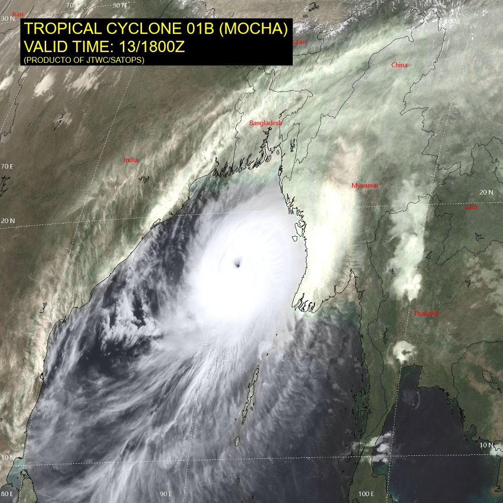
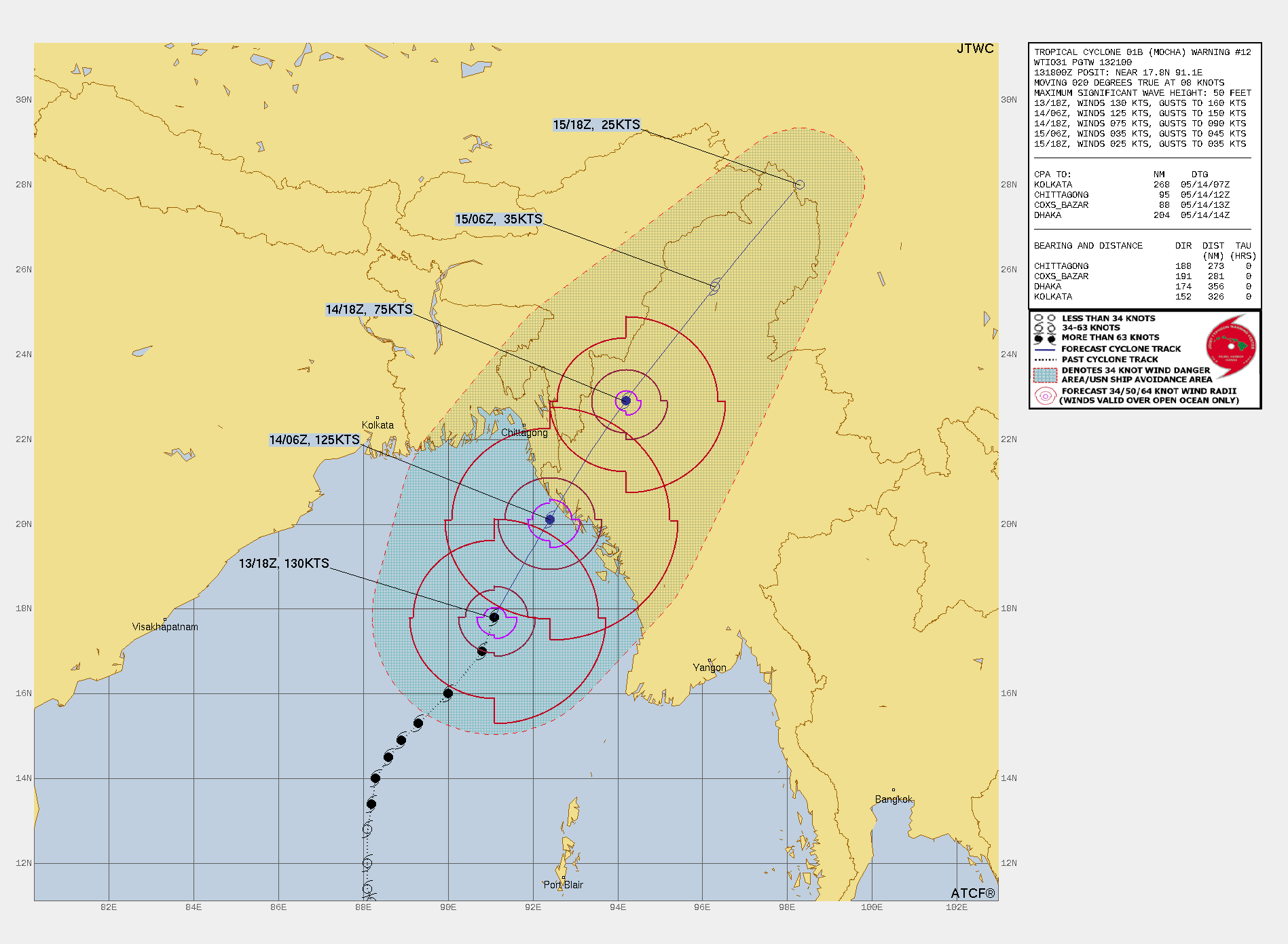
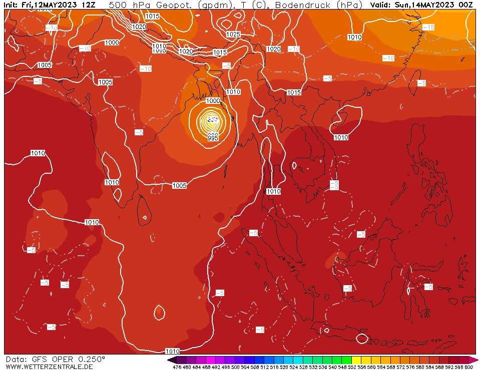
Tropical cyclone MOCHA intensified rapidly in the past 24 hours to an extremely severe cyclonic storm with sustained winds of up to 250 kph, wind gusts of up to 300 kph and the central pressure of the system dropping to 938 hPa. The storm is moving northeastwards at around 18 kph towards the northern coast of Myanmar.

13.05.2023


The favorable conditions over the Bay of Bengal lead to the rapid intensification of the tropical cyclone MOCHA in the past 24 hours. Warm sea surface temperatures, with water temperatures > 30 °C, both strong low-level convergence and upper-level divergence created favorable conditions for tropical cyclone intensification and are expected to prevail. Therefore, the cyclone intensity of extremely severe cyclonic storm MOCHA is expected to remain constant before the landfall of the cyclone.
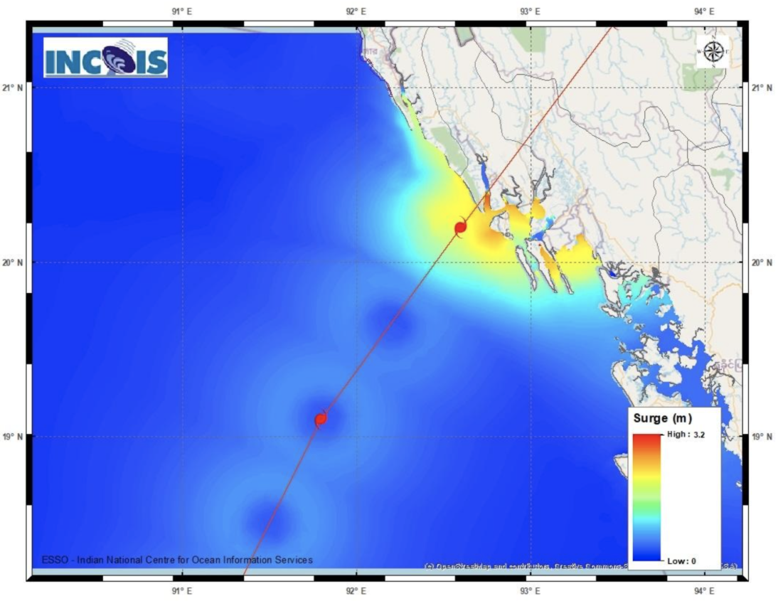
Currently, the cyclone has sustained winds of up to 250 kph and wind gusts of up to 300 kph. The cyclone is moving with around 18 kph to the northeast, with an estimated central pressure of 938 hPa. The current trajectory of MOCHA sees the cyclone hitting the northern coast of Myanmar by tomorrow, May 14, 2023, at around noon close to the mayor city of Sittwe, Myanmar. At landfall, the cyclone is expected to remain very powerful with sustained of up 190 kph and wind gusts of more than 200 kph.

MOCHA is expected to bring an extreme storm surge to northern Myanmar and parts of Bangladesh coast, due shallow shoreline, especially in the region around Sittwe, Myanmar, the effects could be devastating. Furthermore, the cyclone is expected to bring heavy precipitation upon landfall, threatening the world's largest refugee camp along the border of Myanmar and Bangladesh. Due to topography of Myanmar, MOCHA is expected decay rapidly upon reaching land, nevertheless the impacts are expected to be very large.


Friday, 12 May 2023, 20:00 UTC


Visible satellite imagery of very severe
tropical cyclone MOCHA,
12.05 12 UTC
Source: JTWC
Track and intensity forecast for cyclone MOCHA,
12.05 12 UTC
Source: JTWC
500 hPa Geopotential over South Asia,
14.05 00 UTC
Source: wetterzentrale
Accumulated precipitation over South Asia until
15.05
Source: wetterzentrale


Tropical cyclone
Myanmar, Bangladesh

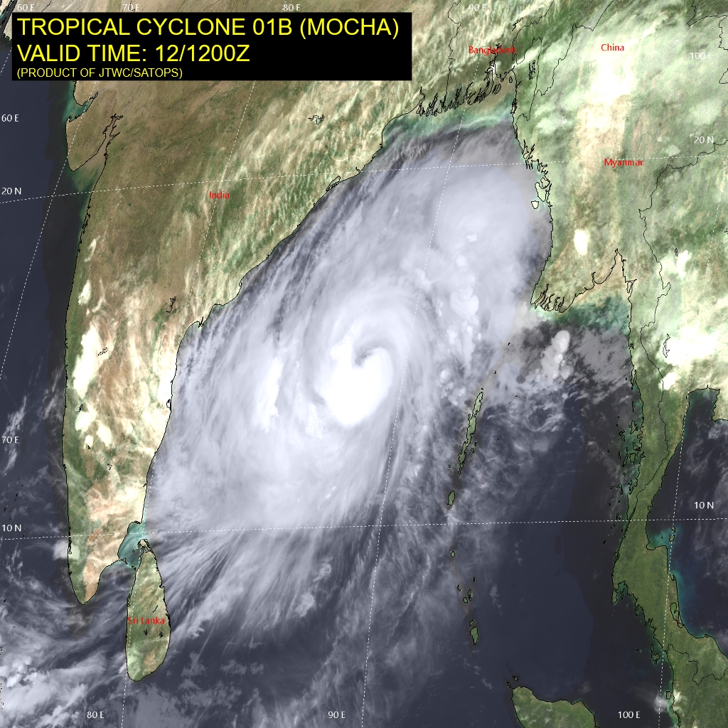
Issued: Friday, 12 May 2023, 20:00 UTC

Very severe tropical cyclone MOCHA is intensifying quickly over the Bay of Bengal, moving northeastwards at 12 kph towards the coast of Bangladesh and Thailand. Currently, the system has sustained winds of up to 165 kph and wind gusts of up to 175 kph, with a central pressure 972 hPa.

12.05.2023


Over the Bay of Bengal, a strong tropical cyclone formed in the past days. By May 11, the cyclonic storm intensified and was named MOCHA. Today, the system intensified rapidly over the Bay of Bengal to a very severe tropical cyclone, which roughly converts to a category 2 hurricane over the Atlantic. The warm ocean waters in Bay of Bengal, with SST in excess of 31 °C and low shear in the mid to upper troposphere gives the potential for a rapid intensification of the cyclone.

Currently, MOCHA has sustained winds of up to 165 kph and wind gusts of up to 175 kph, with a central pressure of 972 hPa, moving north northeastwards at 12 kph. In the coming hours, further intensification of the cyclone is expected due to the favorable environment around the cyclone. The forecast shows the cyclone moving northeastwards towards the northern coast of Myanmar, with sustained winds intensifying to 200 kph and wind gusts increasing to 240 kph, before the expected landfall early on May 14, 2023.

The impact of the cyclone along the coast of Bangladesh and Myanmar is expected to be large, with a very strong storm surge and abundant precipitation, especially in the coastal mountain ranges of Myanmar. The potential for mudslides and flash flooding is given. Though, due to a subtropical ridge steering the cyclone to the northeast, the effects of the cyclone could be less devastating than the cyclone making landfall in the more densely populated Ganges delta, nevertheless the effects of the storm surge could be devastating.


Issued: May 12, 2023, 20:00 UTC
KG

Issued: May 13, 2023, 23:00 UTC
KG


Visit us at
Facebook:

Information on warning levels and icons used
Information on meteoalarm.eu