Wednesday, 20 July 2022, 10:00 UTC
|
|
|
|
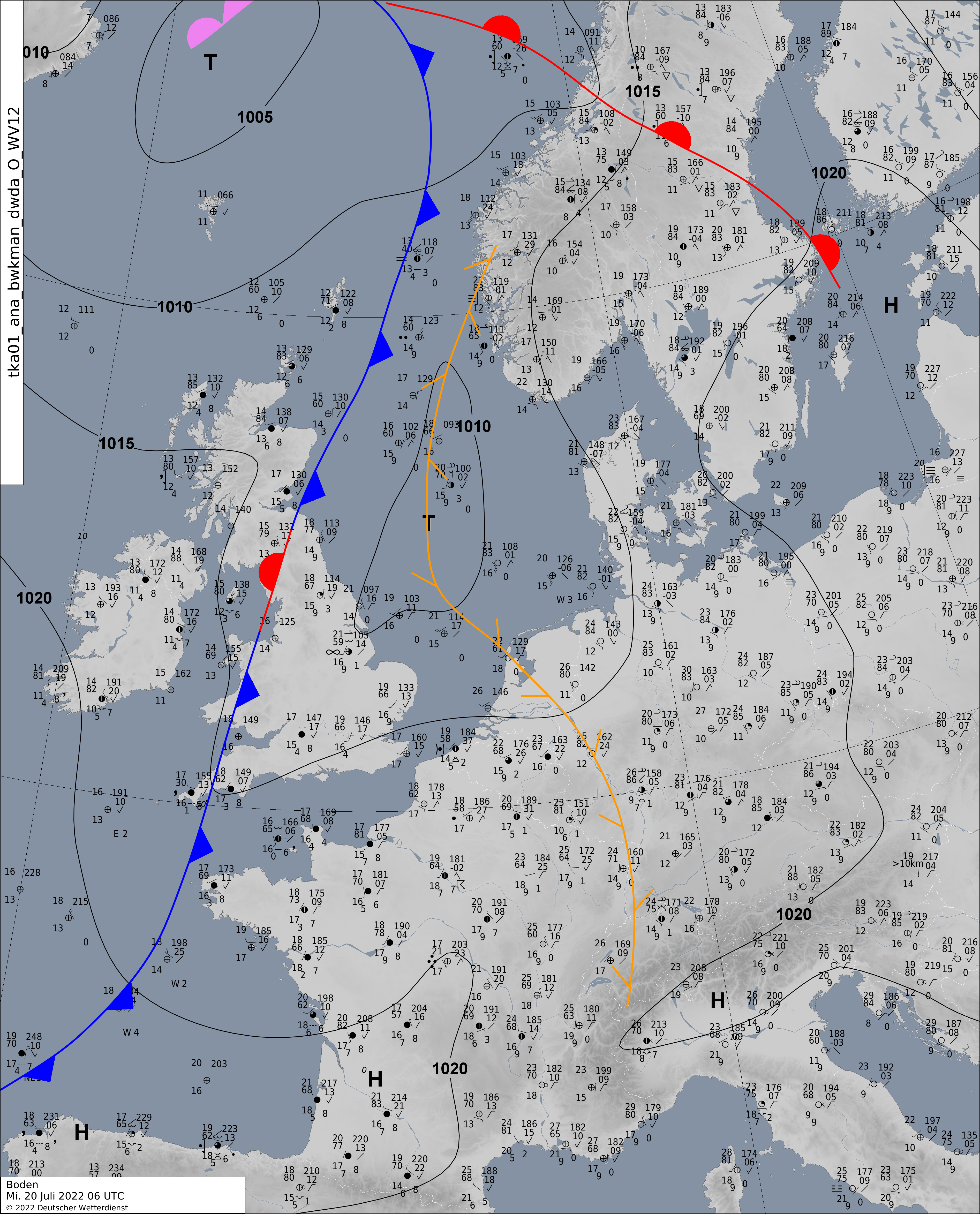
Surface Analysis, 20.07., 06 UTC
Source: DWD
|
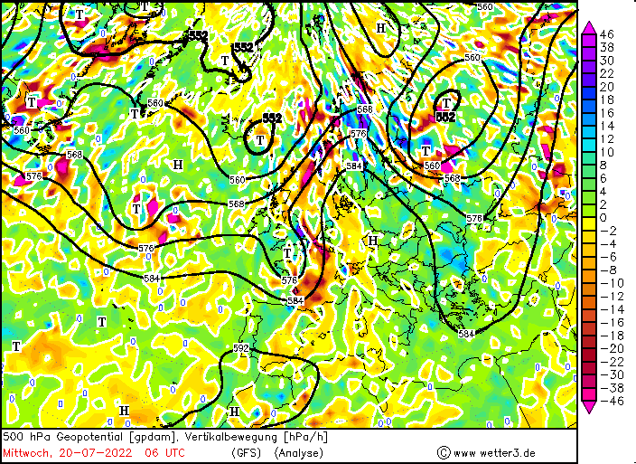
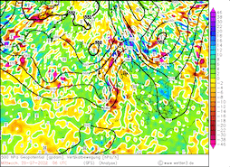
500 hPa Omega velocity over Europe, 20.07., 06 UTC
Source: Wetter3
|
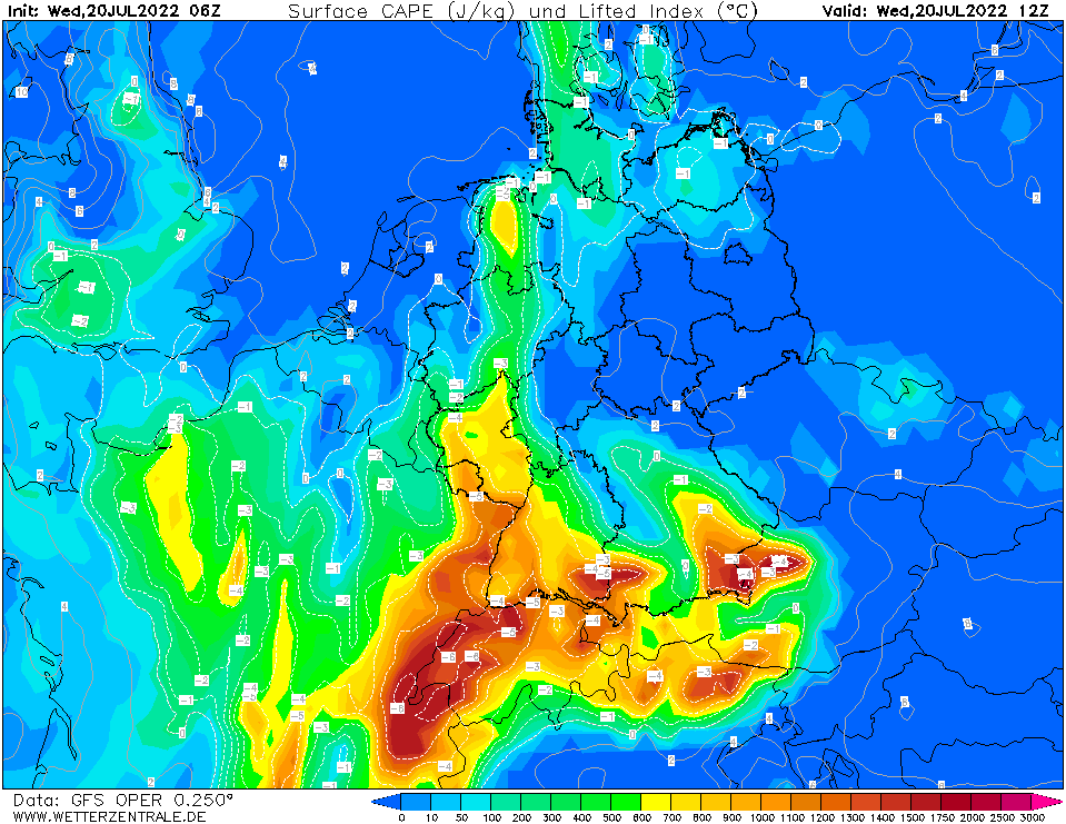
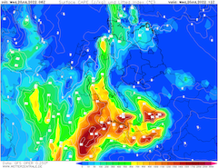
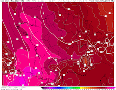
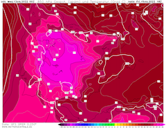
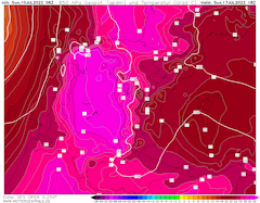
Mixed-layer CAPE over Central Europe,
20.07., 12 UTC
Source: Wetterzentrale
|
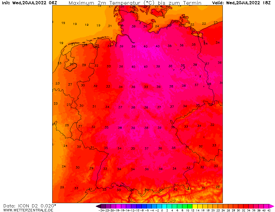
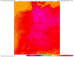
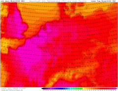
2m maximum temperature Central Europe,
20.07., 18 UTC
Source: Wetterzentrale
|
Heat Wave and Severe Thunderstroms
Central Europe
Issued: Wednesday, 20 July 2022, 10:00 UTC
As the cut-off trough moves north-eastwards over Central Europe, severe heat is induced over Northern Germany with temperatures possibly reaching more than 40 °C, as well as severe thunderstorm activity in the western part of Germany.
20.07.2022
As for the first time in the recorded history for the United Kingdom temperature of more than 40 °C have been measured yesterday, today, July 20, 2022, temperatures over the northern part of Germany are expected to close in on to the 40 °C-mark. With 850 hPa-temperatures nearing the 25 °C-mark in front of cut-off trough, daytime maximum-temperatures are expected surpass the 35 °C-mark significantly over large parts of Central Europe.
As at 09 UTC temperatures in the North German Plain have already surpassed the 35 °C-mark locally, new temperature records seem to be likely in set region, possibly nearing the German all-time record of 41.2 °C from 2019.
In front of the cut-off trough over Western Germany a convergence zone as formed, with mid-level lifting induced by set cut-off trough, possibly severe thunderstorm activity is expected to form in the afternoon and nighttime hours today. With sufficiently high levels of mixed layer CAPE in a small strip over Western Germany and high levels of precipitable water levels above 35 mm high precipitation thunderstorms are possible, inducing locally heavy precipitation and possibly hail.
With very dry soils in Western Germany local flash flooding can´t be excluded if heavy precipitation occurs. Further high DCAPE values give the potential for heavy convective downdrafts connected to set systems, as they move north-eastwards during the evening hours. With a shallow surface low developing over the North German Plain in the evening hours, enduring heavy precipitation ought to be expected in the nighttime hours over the north-western part of Germany.
Monday, 18 July 2022, 10:00 UTC
|
|
|
|
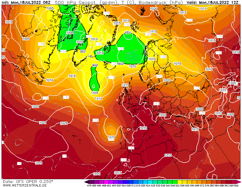
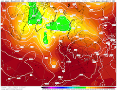
500 hPa-Geopotential, 18.07., 06 UTC
Source: Wetterzentrale
|
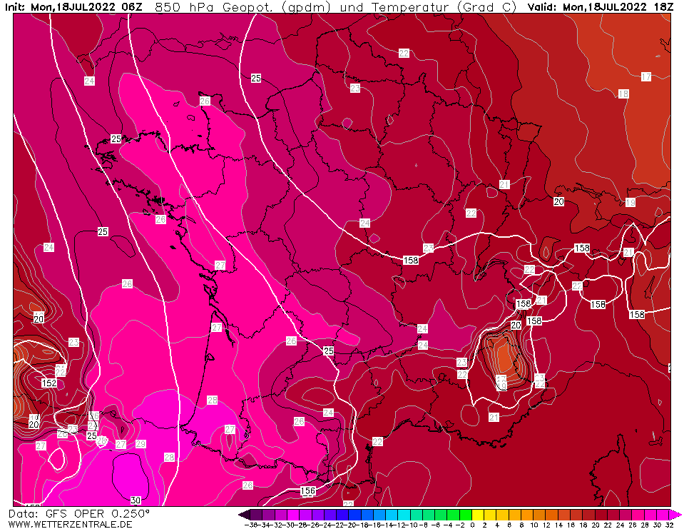
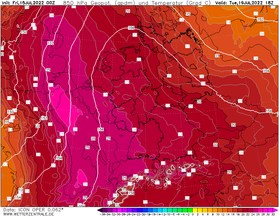
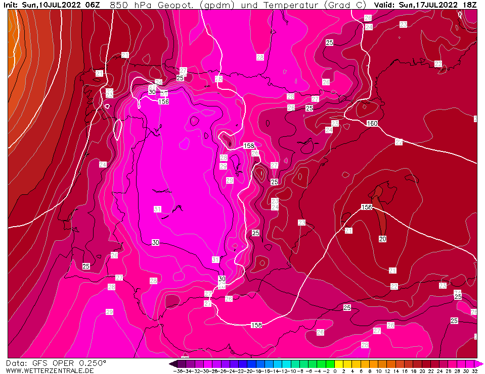
850 hPa-temperature over France, 18.07., 18 UTC
Source: Wetterzentrale
|
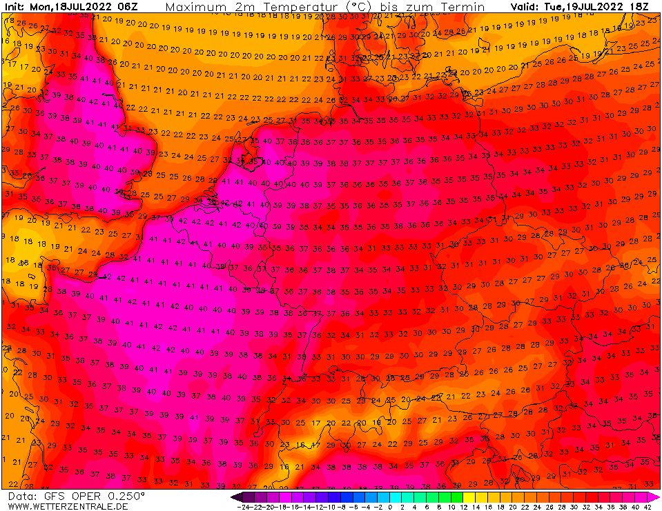
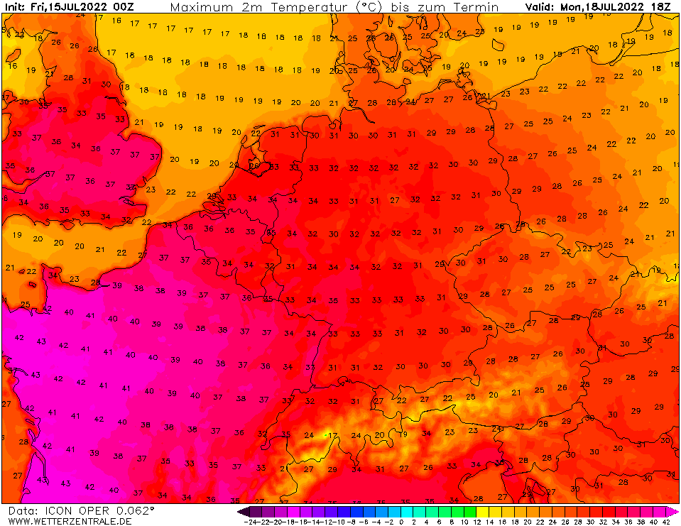
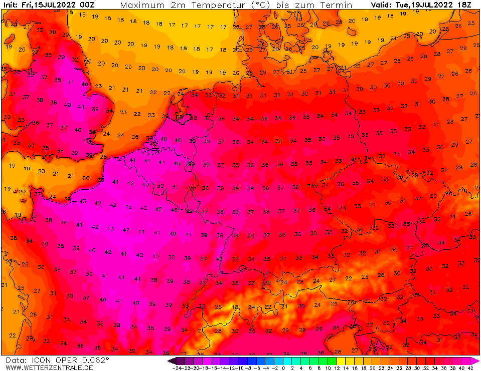
2m maximum temperature Central Europe,
19.07., 18 UTC
Source: Wetterzentrale
|
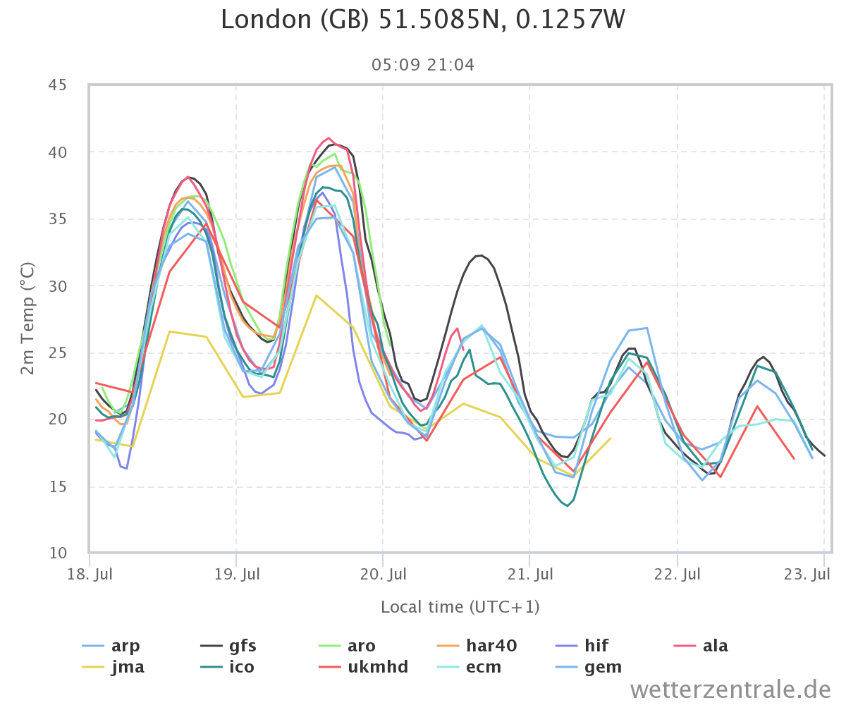
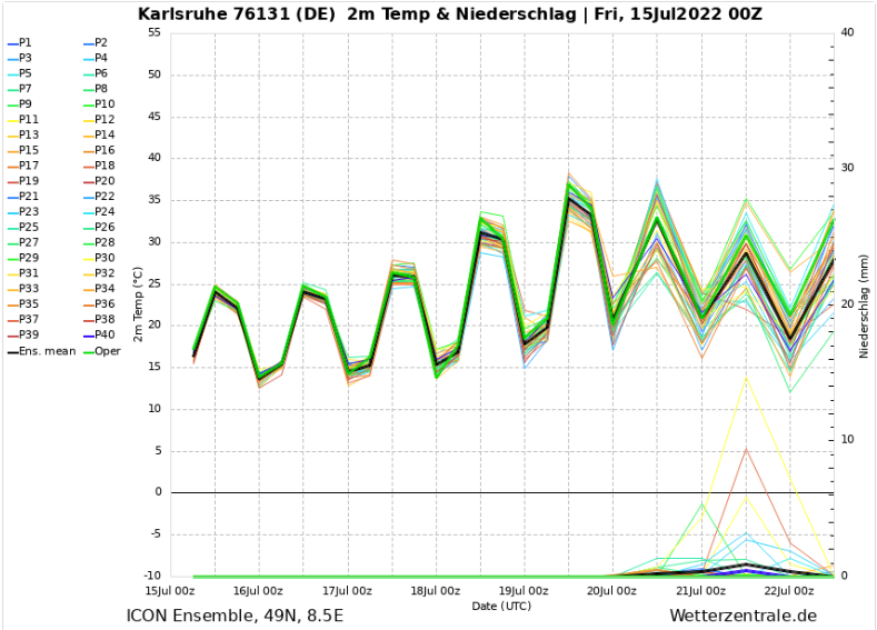
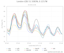
Multi model 2 m temperature ensemble for London,
18.07. until 23.07.
Source: Wetterzentrale
|
Heat Wave
Europe
Issued: Monday, 18 July 2022, 10:00 UTC
With a ridge over Western and Central Europe and a cut-off trough further west very warm air masses advance northward over Europe. Especially over Britain unprecedented heat with temperatures around the 40 °C-mark are possible.
18.07.2022
Today, July 18, 2022, the cut-off trough is still situated off the coast of Portugal, therefore the center of the warmest air masses is still over Western Europe. With 850 hPa-temperatures reaching above the 25 °C-mark, daytime maximum-temperature far above the 40 °C-mark are possible in southern France. As the cut-off trough moves north-eastwards over Europe, the region of highest temperatures advances eastwards.
Especially tomorrow, July 19, 2022, unprecedented heat is possible over large parts of Britain. With the 850 hPa-temperature possibly reaching the 25°C-mark, daytime maximum-temperatures around the 40 °C-mark seem feasible, possibly shattering the all-time record of 38.7 °C in England. Yet there is still some ambiguity between different numerical weather models about the maximum temperature on Tuesday.
Temperatures across Central Europe are also expected to reach far above the 35 °C-mark in the coming days, with the highest temperatures tomorrow over the western part and on Wednesday, July 20, 2022, over the eastern part of Germany. On Wednesday dewpoints are expected to increase with lowered static stability thunderstorm activity with the closing trough ought to be expected moving eastwards over Central Europe.
Subsequently a drop in temperature is expected, yet over the southern part of Germany it must be questioned whether the drop in temperatures below the 30 °C-mark will be lasting. As it is not expected for trough to zonalize the flow over Europe.
Friday, 15 July 2022, 07:00 UTC
Heat Wave
Europe
Issued: Friday, 15 July 2022, 07:00 UTC
A high ridge will provide cloudless skies over Central Europe at the beginning of the coming week. A closing cut-off low from the west will additionally
lead hot air masses from the south and southwest to Germany. On Tuesday, values around 40° C possible in western Germany.
15.07.2022
Today, Friday, and for the rest of the weekend, Germany will be located on the back side of a trough and will thus come under the influence of relatively
cool air flowing in from the north and northwest. The maximum daytime temperatures will hardly exceed 25° C, at night the temperature will drop to below
10° C in many locations. Only in the Rhine valley and on the coast it will remain somewhat warmer at night.
With the beginning of the new week, a high pressure ridge moves over Central Europe. In addition, a cut-off low approaches from the southwest, which has been
stationary off the coast of Portugal for several days. In this course, hot air from the south and southwest is directed to Germany. Temperatures in 850 hPa
reach values of up to 26° C. On Monday, near the ground the highest temperatures will occur in western France. Here, values just above the 40° C mark
are expected. On Tuesday, the heat will then continue to shift to the east. Then, in large parts of Germany, especially in the west, more than 35° C are
possible. On the border with Benelux, the 40° mark can be broken. Also on Wednesday, it will remain hot across Germany, with the focus of the heat wave
over Saxony-Anhalt and Brandenburg. Values around 38° are possible.
No precipitation is expected up to and including Tuesday. Only in the very northern part of Germany there will be a few showers over the weekend. The already
dry soils in large parts of Germany will not see any water until Wednesday at the earliest. However, productive precipitation is not expected in the medium term.
Wednesday, 13 July 2022, 08:00 UTC
|
|
|
|
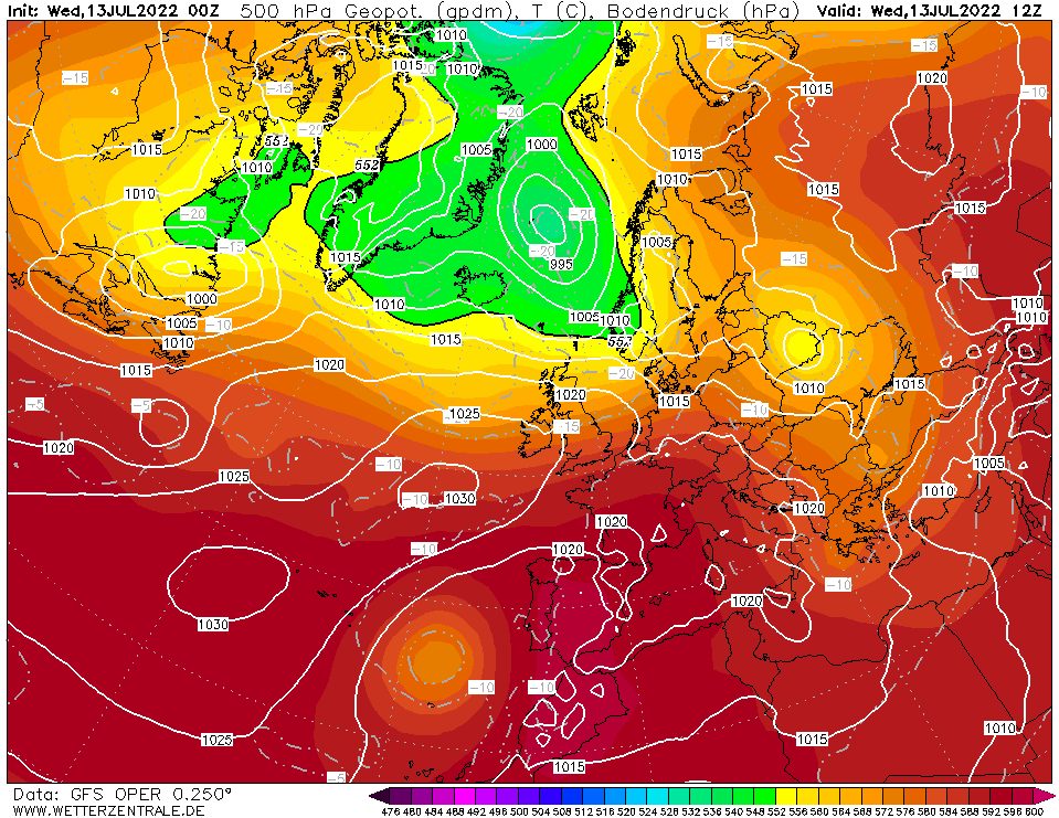
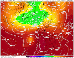
500 hPa Geopotential height Europe,
13.07., 12 UTC
Source: Wetterzentrale
|
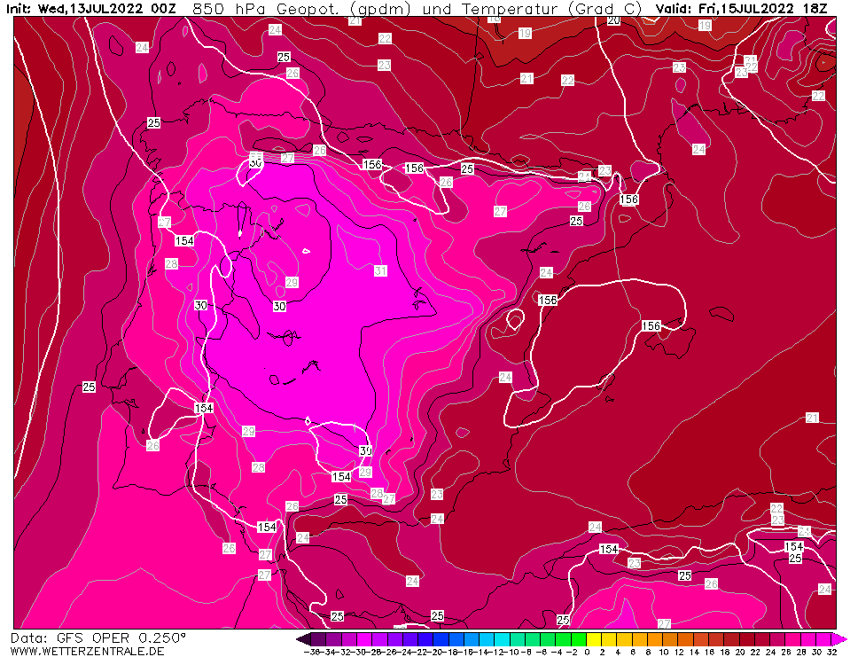
850 hPa temperature and Geopotential height
Iberian Peninsula, 15.07., 18 UTC
Source: Wetterzentrale
|
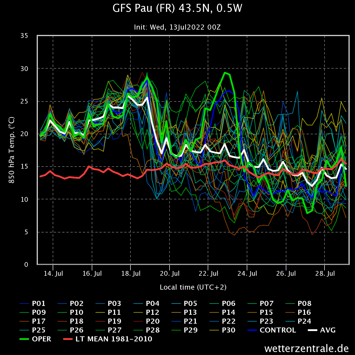
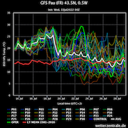
GFS 850 hPa-temperature ensemble
for Pau (FR)
Source: Wetterzentrale
|
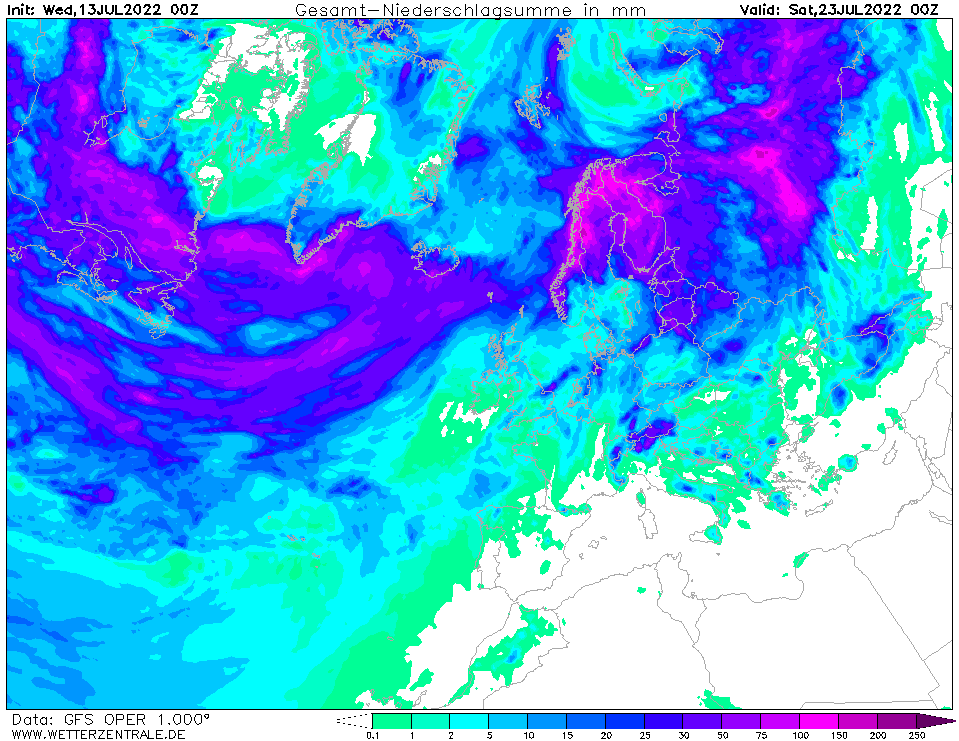
Accumulated precipitation over Europe until
23.07., 00 UTC
Source: Wetterzentrale
|
Heat Wave
Europe
Issued: Wednesday, 13 July 2022, 08:00 UTC
The combination of a cut-off trough over the Atlantic Ocean off the coast of Portugal and a ridge over the Iberian Peninsula very warm air masses advance northwards over Europe.
13.07.2022
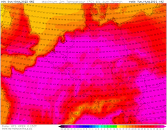
With the cut-off low off the coast of Portugal very warm airmasses from Northern Africa advance northward over the Iberian Peninsula with 850 hPa-temperatures close to the 30 °C-mark. Therefore, severe heat ought to be expected over large parts of the Iberian Peninsula, especially in lower regions, with temperatures possibly exceeding the 45 °C-mark in the coming days. In the coming week temperatures are expected to slightly drop down to the 40 °C-mark.
As stated in the previous advisory, in the coming week the cut-off trough will be reintegrated into the main westward current relating to a higher uncertainty in the forecast. In the first part of next week from Monday, July 18, 2022, to Wednesday, July 20, 2022, the ridge, currently above the Iberian Peninsula, will move eastwards over Europe as the cut-off trough is reintegrated into the main westward current.
Therefore, many European countries will come under the influence of very warm air masses. In France, especially in the southern part, 850 hPa-temperatures are expected to exceed the 25 °C-mark, leading to the daytime high-temperatures to reach well above the 40 °C-mark. In Central Europe after a short heat wave today, July 13, 2022, and tomorrow, July 14, 2022, and subsequent cooler days, temperatures are expected to rise again in the coming week. With 850 hPa-temperatures reaching slightly above the 20 °C-mark, daytime high-temperatures are expected to reach above 35 °C, locally closing in on the 40 °C-mark.
With precipitation activity very limited across large parts of Western and Central Europe, drought conditions are expected to worsen, therefore increasing the fire risk.
Sunday, 10 July 2022, 13:30 UTC
|
|
|
|
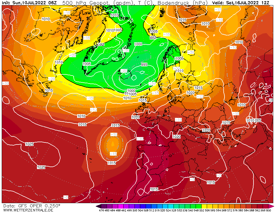
500 hPa Geopotential height Europe,
16.07., 12 UTC
Source: Wetterzentrale
|
850 hPa temperature and Geopotential height
Iberian Peninsula, 17.07., 18 UTC
Source: Wetterzentrale
|
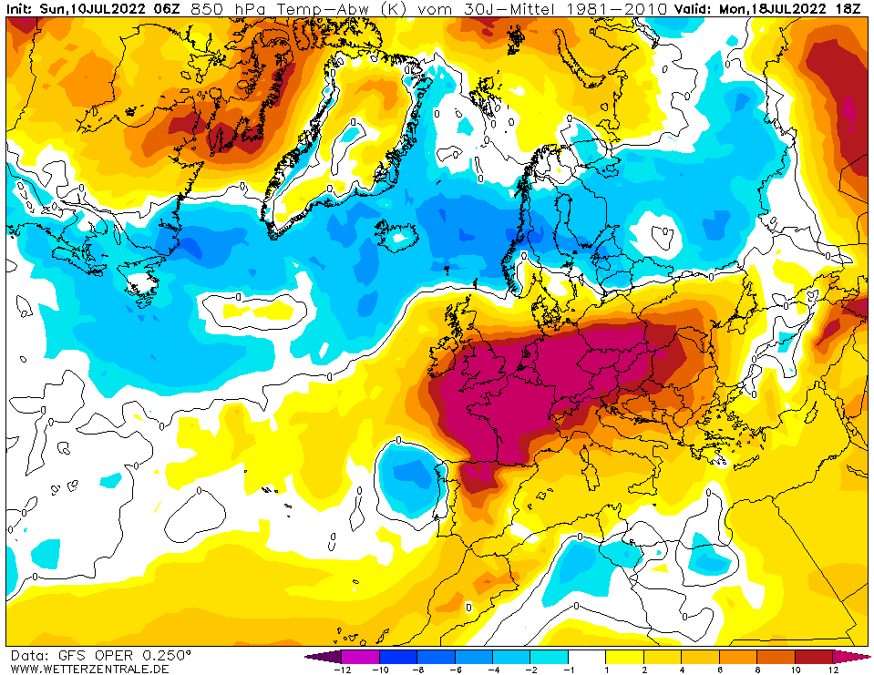
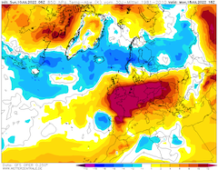
850 hPa temperature deviation Europe,
18.07., 18 UTC
Source: Wetterzentrale
|
6 h maximum temperature Central Europe,
19.07., 18 UTC
Source: Wetterzentrale
|
Heat Wave
Europe
Issued: Sunday, 10 July 2022, 13:30 UTC
As in the first heat wave of this summer season, first Western Europe and later Central and Eastern Europe are expected to come under the influence of a ridge currently above the Iberian Peninsula. In a combination with a cut-off low off the coast of Portugal extremely hot air masses are expected to reach Europe in the coming week.
10.07.2022
The weather pattern of the coming heat wave is already visible in today's weather map with a ridge over the Iberian Peninsula and a cut-off trough over the Atlantic Ocean. In the coming days the combination of ridge and cut-off trough is expected to move eastwards gaining influence over the weather over Europe in the coming week. With this ridge extremely hot air masses are expected to reach large parts of Europe.
Throughout this week 850 hPa-temperatures over the Iberian Peninsula are expected to reach values above 25 °C, leading to day-time high-temperatures fdyching more than 40 °C in lower regions. In a first step significantly warmer air masses get transported over Western and Central Europe, with 850 hPa-temperatures reaching 25 °C over Southern France and 17 °C over Southern Germany, leading to day-time high-temperatures of more than 40 °C and up 35 °C respectively. From Thursday, July 14, 2022, to Saturday, July 16, 2022, a trough over the North Sea gains influence over Central Europe leading to a short-lived drop in temperatures.
On the coming weekend the cut-off trough moves eastwards towards the Iberian Peninsula, extremely hot air masses from Northern Africa get therefore transported above the Iberian Peninsula. With 850 hPa-temperatures reaching possibly more than 30 °C, day-time high-temperatures could reach up to 47°C in lower regions, closing in on the all-time high-temperature record of Europe of 48.0 °C.
In the following week the cut-off trough is expected to be reintegrated into the main westward current, transporting the extremely hot air masses further across Western and Central Europe. With 850 hPa-temperature reaching possibly values well above the 25°C-mark, and 850 hPa-temperature deviation reaching possibly more than +15 K, all-time high record can possibly be shattered by multiple degrees across many European countries. Extreme model runs, especially of the GFS-model, calculate day-time high-temperatures reaching 45 °C over many parts of Western and Central Europe, also therefore impacting the Tour de France. Up to four days with day-time high-temperatures reaching more than 40 °C are possibly expected. Even in England temperatures above the 40 °C-mark could possibly be reached. Due to very low dewpoints, not far above the 0 °C-mark, desert like condition can be expected over many parts of Western and Central Europe. With high static stability, due to the ridge in front of the cut-off trough. thunderstorm activity is expected to be scarce, enhancing drought conditions over much of Europe.
As the reintegration of such a cut-off trough into the main current is always connected to a higher uncertainty, still a large temperature spread is currently in the forecast for Europe. Giving the chance for a fast reintegration of set cut-off trough into the westward current, leading to significantly lower day-time high-temperatures well below the 40 °C-mark for Central Europe. Yet ensemble members over Central Europe cluster around 23°C in 850 hPa from Monday, July 18, 2022, to Wednesday, July 20, 2022, suggesting a reasonably high chance for temperatures reaching more than 40 °C in set timespan over Central Europe.
Issued: July 10, 2022, 13:30 UTC
KG
Issued: July 13, 2022, 08:00 UTC
KG
Issued: July 15, 2022, 07:00 UTC
FS
Issued: July 18, 2022, 10:00 UTC
KG
Issued: July 20, 2022, 10:00 UTC
KG
|