Saturday, 26 December 2020, 11:30 UTC
|
|

|
|
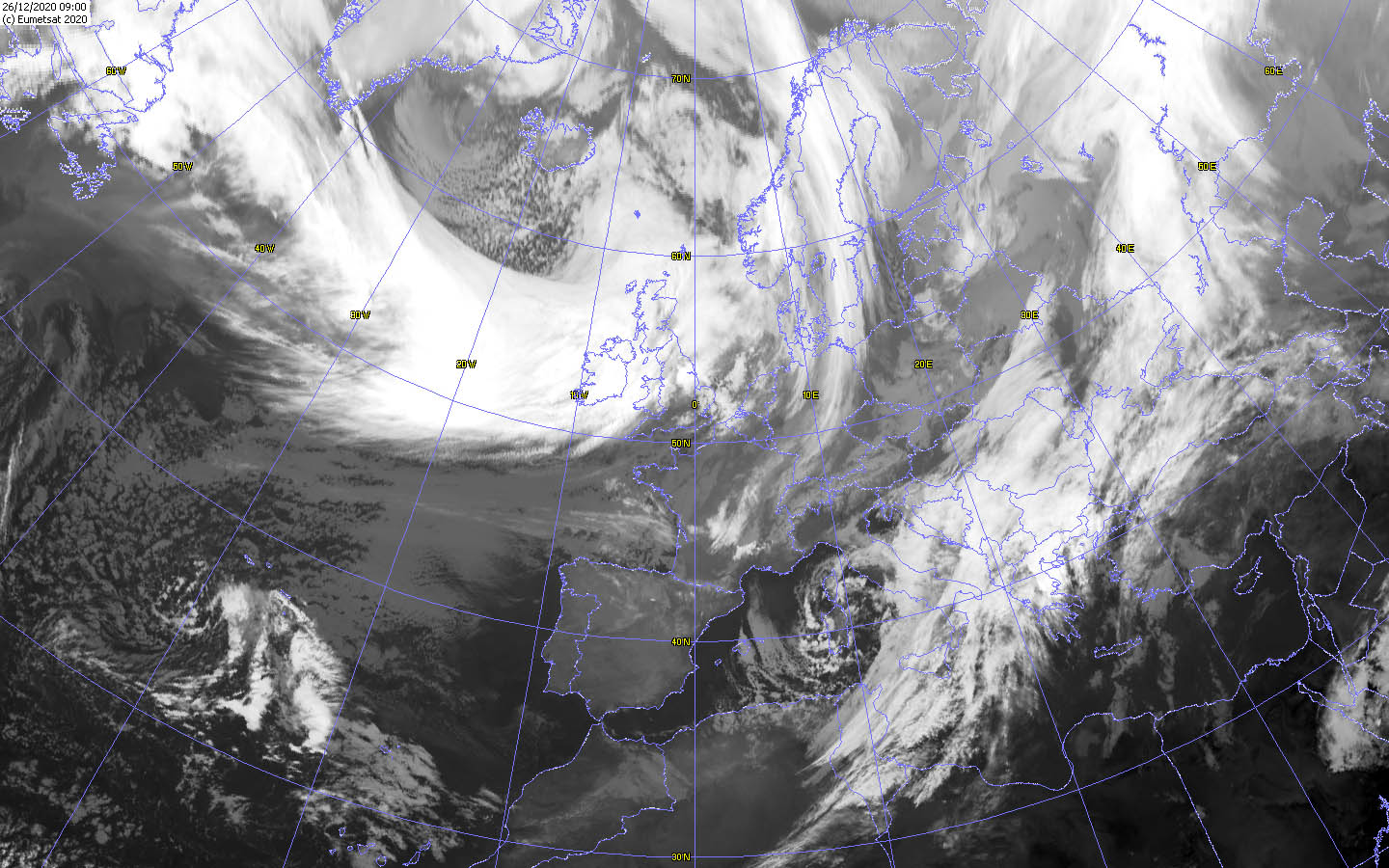
Satellite image (VIS), 26.12. 09 UTC
Data Source: Wokingham
|
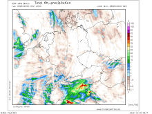
Total 6h precipitation, 28.12. 09 UTC
Data Source: Modellzentrale
|
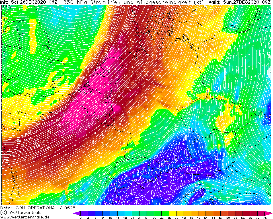
850 hPa Wind Central Europe, 27.12., 09 UTC
Data Source: Wetterzentrale
|
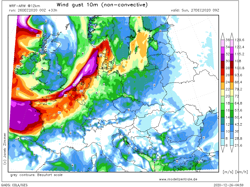
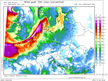
10m Wind gusts Central Europe, 27.12., 09 UTC
Data Source: Modellzentrale
|
Winterstorm
Europe
Issued: Saturday, 26 December 2020, 11:30 UTC
The storm field of Winter Storm HERMINE will reach Ireland and England in the next few hours. At exposed locations, gusts above 120 km/h are expected,
at lower altitudes gusts up to 60 km/h are not excluded. A snowstorm is expected over the Alps on Monday.
26.-29.12.2020
A strong storm low is heading for the British Isles and Europe. Winter storm HERMINE with a core west of the British Isles will cause stormy and especially
in the Alps snowy weather in the next few days. HERMINE is not a fast-moving storm low like GRETA in the past days and therefore moves comparatively slowly towards
the east. The core pressure is currently 965 hPa and will drop to around 960 to 955 hPa by Sunday morning. The core itself will shift towards Scotland by
Sunday noon and move over Whales and England towards the English Channel and Bay of Biscay by Monday. HERMINE has a massive storm field on its southern and
southwestern flanks, which will impact Ireland and Scotland in the next few hours. Gusts up to 150 km/h are not excluded in exposed locations, at lower
altitudes gusts up to 60 km/h are expected. Tonight, the storm field with unchanging strength will then also spread to England. During Sunday night and
Sunday morning, the storm field will intensify and extend over the southern part of England, the northern part of France, the BeNeLux states, as well as
northwestern Germany and Denmark. Here, too, gusts of around 150 km/h are expected in exposed locations. The extreme wind speeds are caused by the high air
pressure gradient as well as by the massive frontal system of HERMINE. As the day progresses, the frontal system and thus also the storm field will shift
further south and thus spread to southern France and almost all of Germany (except southeastern Bavaria) and reach the southwestern parts of Scandinavia.
The BeNeLux countries and Denmark also remain in the area of influence of the storm field. In exposed locations, gusts around 150 km/h are still expected,
in the lowlands wind speeds up to 50 km/h are expected, in France gusts around 60 km/h are not excluded. Rain, snow and graupel showers will also form in the
area of the cold front. In their vicinity, gusts around 100 km/h or higher can also occur in the lowlands, as the wind speeds from high altitudes are transported
to the ground by the precipitation.
In the night to Monday, the storm field weakens over northern and central Europe, but it intensifies over the southeastern parts of Spain and from Monday afternoon
also over Italy (especially northern Italy) and the Balkan states. Wind speeds around 120 km/h are expected there on Monday. In addition, the F—hn will form over the
Alps, and on the southern side of the Alps, accumulated precipitation will form (mainly in the form of snow), which may bring up to half a meter of fresh snow by
Monday evening. Locally, these may also turn out to be higher, reaching almost 1m. The significant snowfall may limit visibility conditions and combined with the
strong winds, Blizzard-like conditions are expected.
Issued: December 26, 2020, 11:30 UTC
MG
|