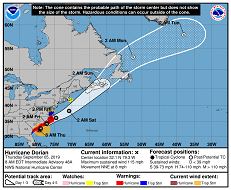
Friday, 06 September 2019, 15:00 CET

|

|

|
|
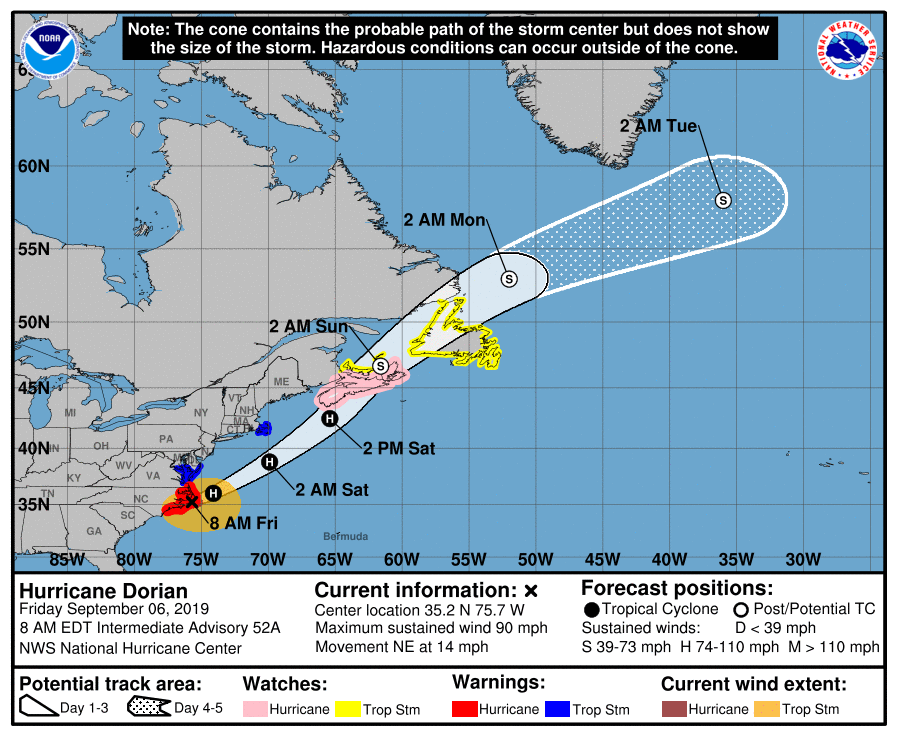
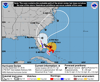
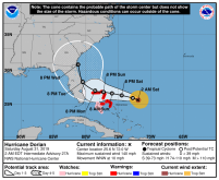
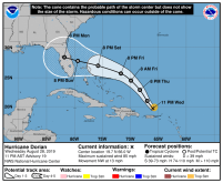
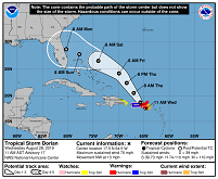
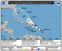
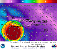
DORIANs predicted trajectory, 06.09., 12 UTC
Image Credit: NHC / NOAA
|
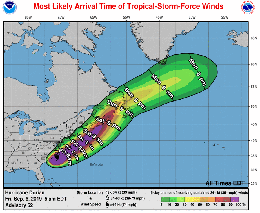
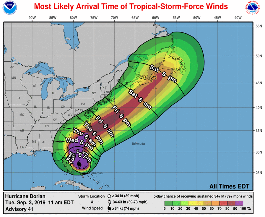
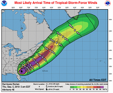
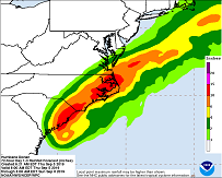
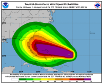
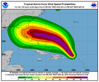
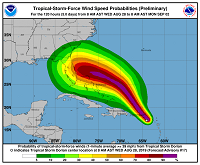
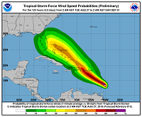
Tropical-storm-force-winds probability
and their most likely time of arrival
06.09., 12 UTC,
Image Credit: NHC / NOAA
|
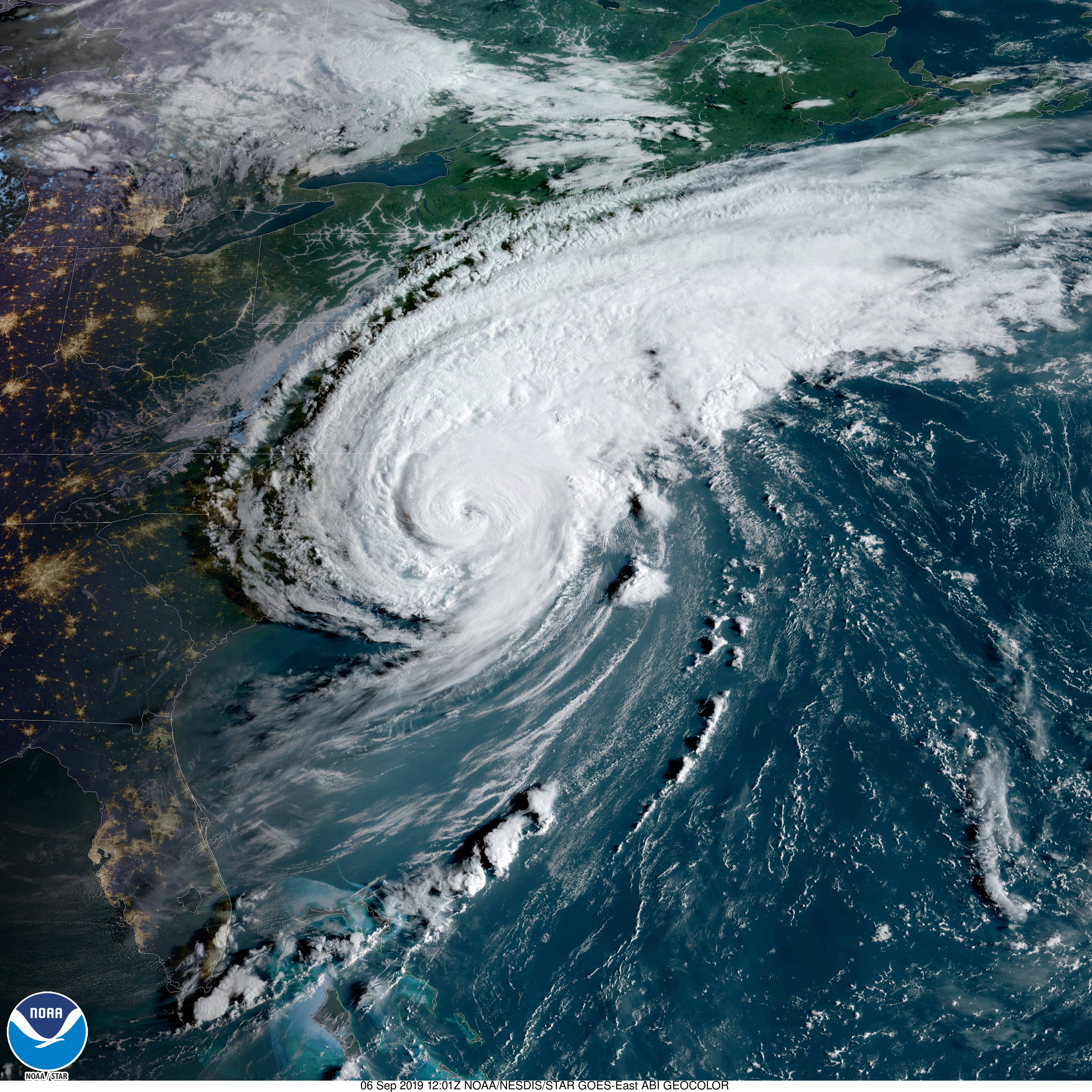
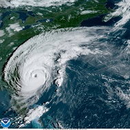
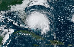
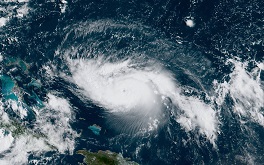
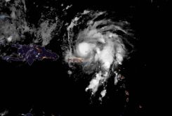
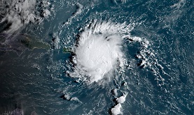
Satellite images, 06.09., 12:01 UTC
Image Credit: NOAA GOES Image Viewer
|
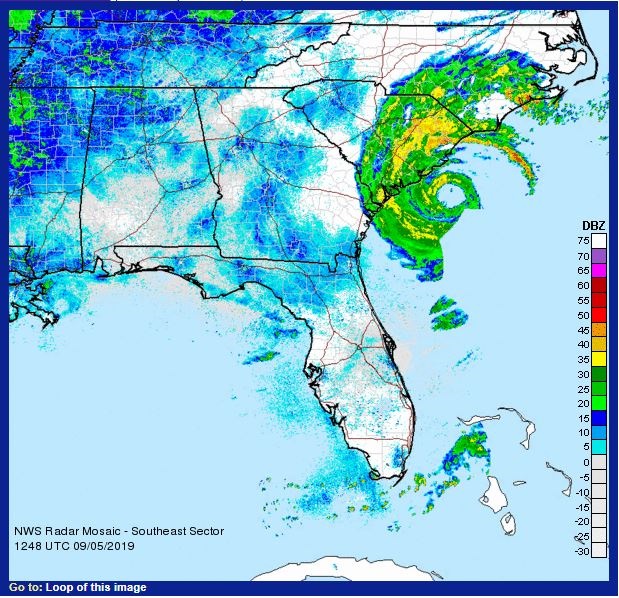
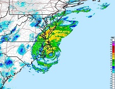
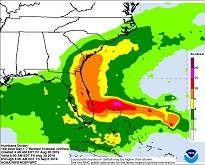
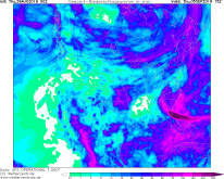
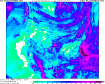
Rain radar, 05.09., 11:58 UTC
Image Credit: NWS / NOAA
|
Hurricane DORIAN
Carribean, Eastern USA, Eastern Canada, Eastern Canada
Issued: Friday, 06 September 2019, 15:00 CET
Category 1 hurricane DORIAN aprroaches the east coast of North Carolina. Mean winds up to 150 kph, extensive rainfall
and storm surge possible in North Carolina and Virginia. DORIAN will decrease to a post-tropical storm in the night to Sunday.
27 Aug - 09 Sep 2019
The eye of hurricane DORIAN is currently (12 UTC) located only about 15 km west of Cape Hatteras, North Carolina. The storm
moves with a displacement speed of 22 kph in a northeasterly direction and grinds over the Outer Banks. DORIAN's winds still
reach velocities of up to 150 kph, in gusts up to 185 kph. Its core pressure is 956 hPa.
The hurricane-like winds still extend within a radius of 75 km around the centre. The tropical-storm-force winds occur even in within 350 km distance to DORIANS eye.
It is expected that DORIAN's intensity will hardly change in the next 24 hours. Only at Sunday, 08 September 00 UTC, the system
will have weakened to a post-tropical storm. In Nova Scotia and Newfoundland, wind speeds of up to 120 kph still must be expected.
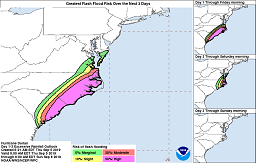
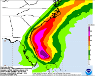
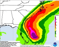
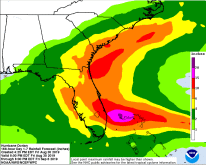
Today, storm surges of up to 2 m have to be expected on the east coast of North Carolina and Virginia.
In the northeast of North Carolina and in the southeast of Virginia, up to 200 mm precipitation may still fall, locally even more.
In the southeast of New England as well as in Nova Scotia up to 125 mm are possible, in Newfoundland up to 50 mm.
Thursday, 05 September 2019, 16:00 CET
|
|
|

|
DORIANs predicted trajectory, 05.09., 12 UTC
Image Credit: NHC / NOAA
|
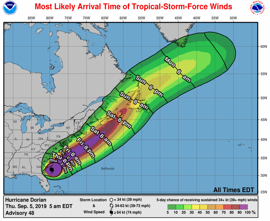
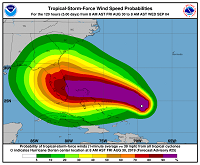
Tropical-storm-force-winds probability
and their most likely time of arrival
05.09., 12 UTC
Image Credit: NHC / NOAA
|
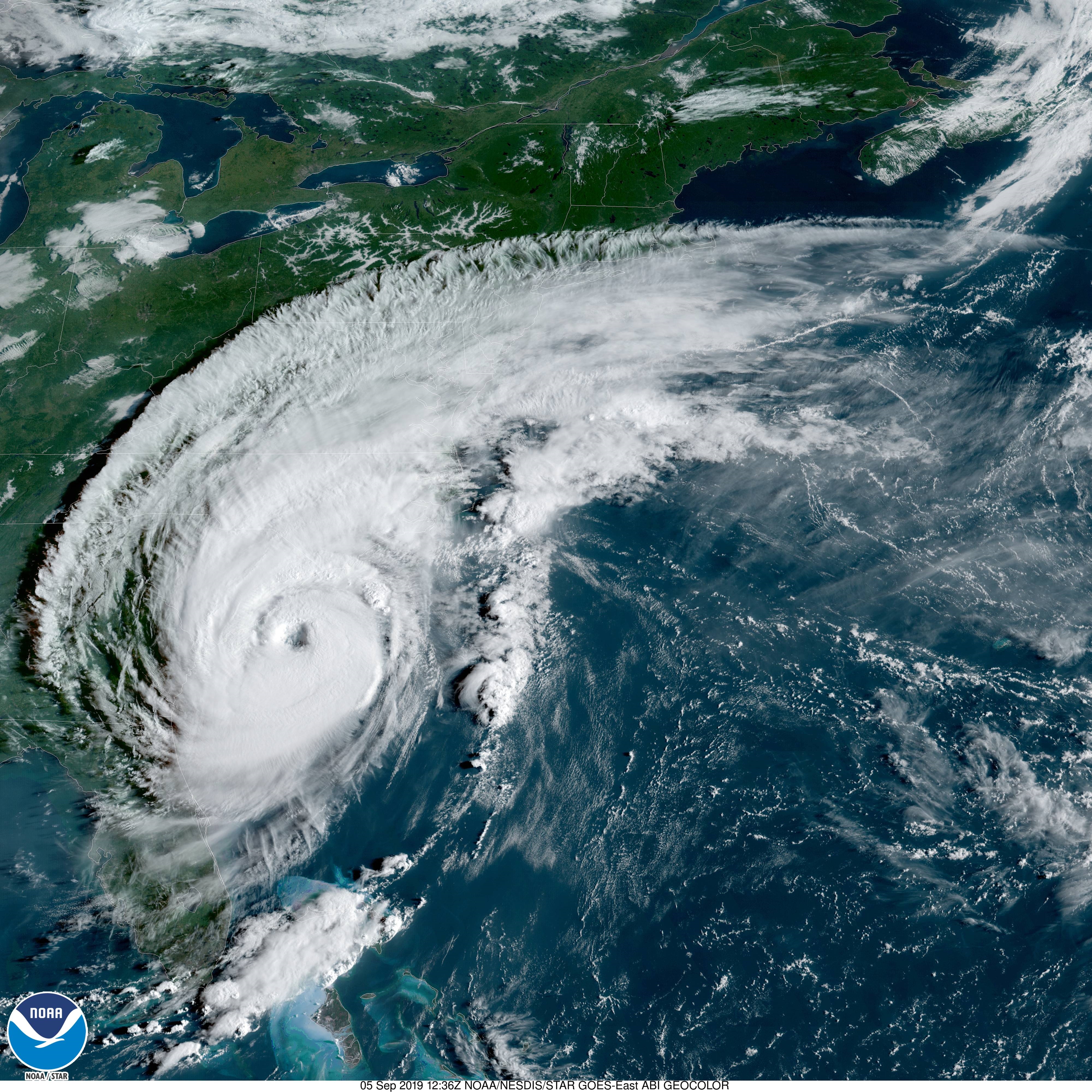
Satellite image (visbile), 05.09., 12:36 UTC
Image Credit: NOAA GOES Image Viewer
|
Rain radar, 06.09., 11:48 UTC
Image Credit: NWS / NOAA
|
|
|

|
|
Predicted accumulated precipitation,05.09. 12 UTC
Image Credit: NHC / NOAA
|
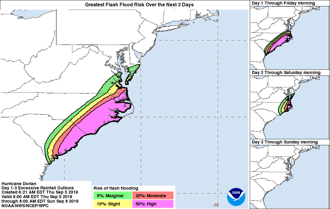
Flash flooding risk,
05.09. 12 UTC until 08.09. 12 UTC
Image Credit: NHC / NOAA
|
Rain radar, 05.09., 12:48 UTC
Image Credit: NWS / NOAA
|
Supercell risk, 05.09., 12 UTC
Image Credit: SPC / NOAA
|
Hurricane DORIAN
Carribean, Eastern USA, Eastern Canada, Eastern Canada
Issued: Thursday, 05 September 2019, 16:00 CET
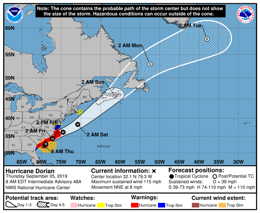
Hurricane DORIAN maintaned category 3 status and is moving along the east coast of Florida, Georgia and Carolina. Still life threatening
situation due to hurricane-like winds, rain up to 400 mm and storm surge up to 2.5 m.
27 Aug - 09 Sep 2019
With mean winds of 185 kph and gusts of up to 225 kph, hurricane DORIAN still belongs to category 3. Its core
pressure also remains largely unchanged at 959 hPa. The system is currently located about 90 km southeast
of Charleston, South Carolina, and moves north-northeast at 13 kph. As a result, the eye of the storm is
slowly approaching the mainland. DORIAN is expected to make landfall on Friday at 10 UTC in Havelock, North
Carolina. Already about 6 hours later the eye of the storm will be over open sea again and will then move
away from US mainland in a northeastern direction.
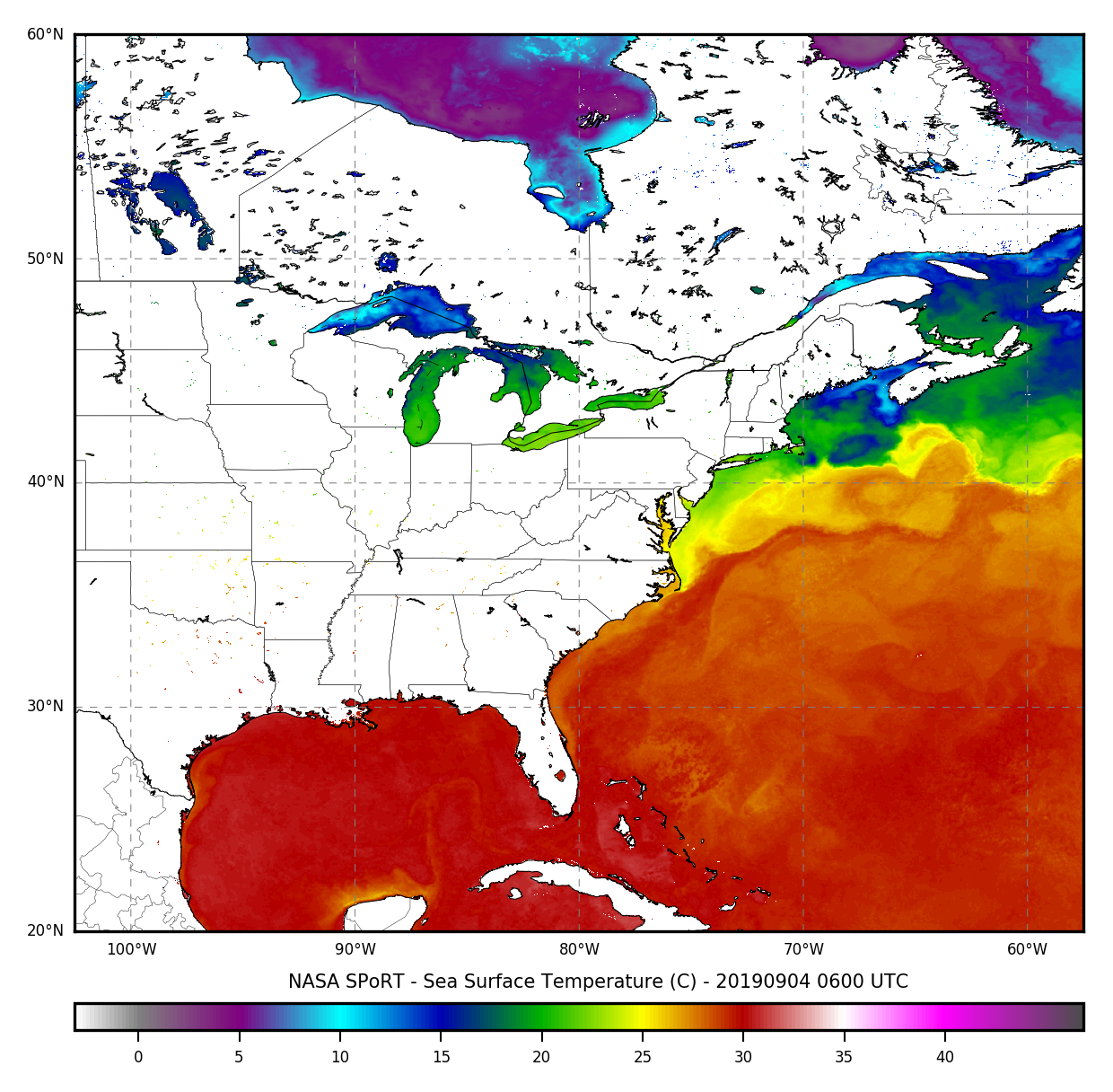
One reason for the remarkable durability of the hurricane is the fact that the system still benefits from
very warm water masses. Even on the coast of North Carolina the sea surface temperature is still up to 30°C.
Only when the hurricane crosses the Gulf Stream in a northerly direction and encounters significantly colder
water masses (SST ≤ 25°C) it will weaken significantly. According to current forecasts, DORIAN will maintain
its hurricane status until 08 September. With the predicted trajectory this would imply landfall on Nova Scotia
and possibly even Newfoundland as a hurricane.
Hurricane DORIAN has enormous potential of danger in various aspects.
In the coastal areas of Florida, Georgia, South- and North Carolina and in the southeast of Virginia there is danger
from hurricane-like winds.
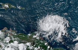
In the same states there is also danger from heavy rain and thunderstorms. As can be seen from the satellite image,
the remarkable cloud coverage from DORIAN extends far inland. Thundestorms with hurricane-like gusts and flash-flooding
amounts of precipitation are not only possible in coastal areas but also far inland.
In the area of the outer Eyewall (currently above South and North Carolina) super cells with isolated tornadoes may form.
There is also a significant risk of storm surges of up to 2.5 m in South- and North Carolina and in the southwest of Virginia.
In the bays and river estuaries around Pamlico Sound (North Carolina) the storm surge can be even higher.
Tuesday, 03 September 2019, 18:45 CET
|
|
|
|
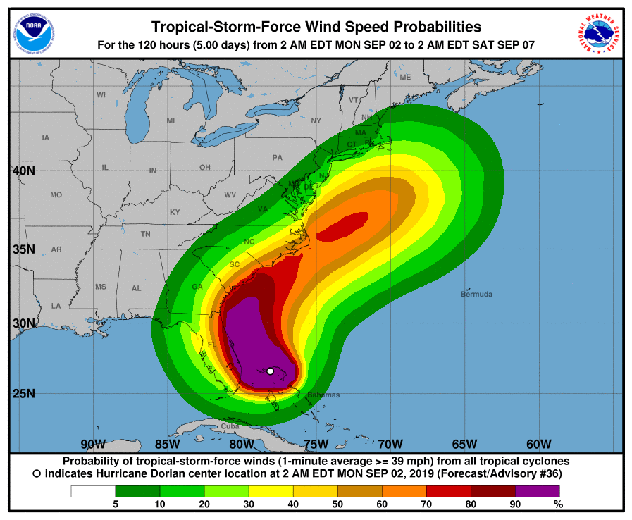
Tropical-storm-force-winds probability
and their most likely time of arrival
03.09., 15 UTC,
Image Credit: NHC / NOAA
|
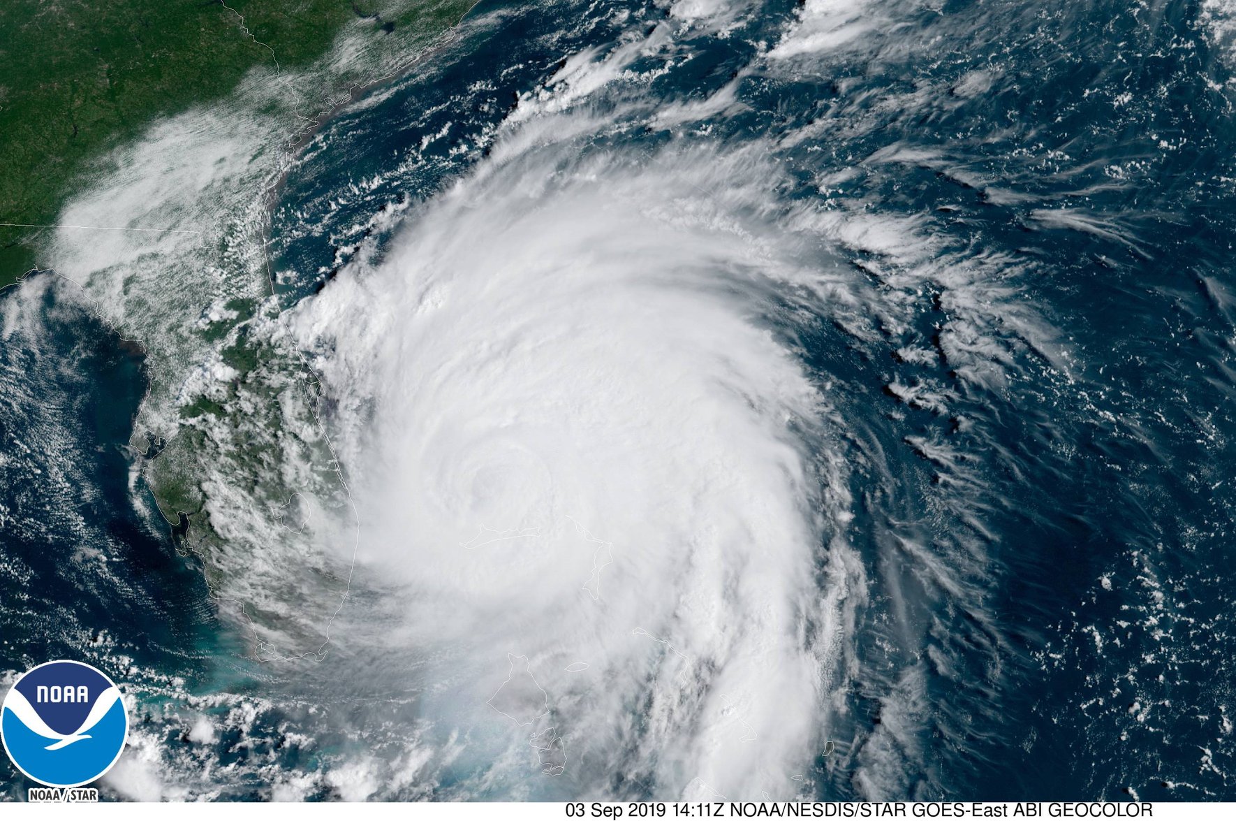
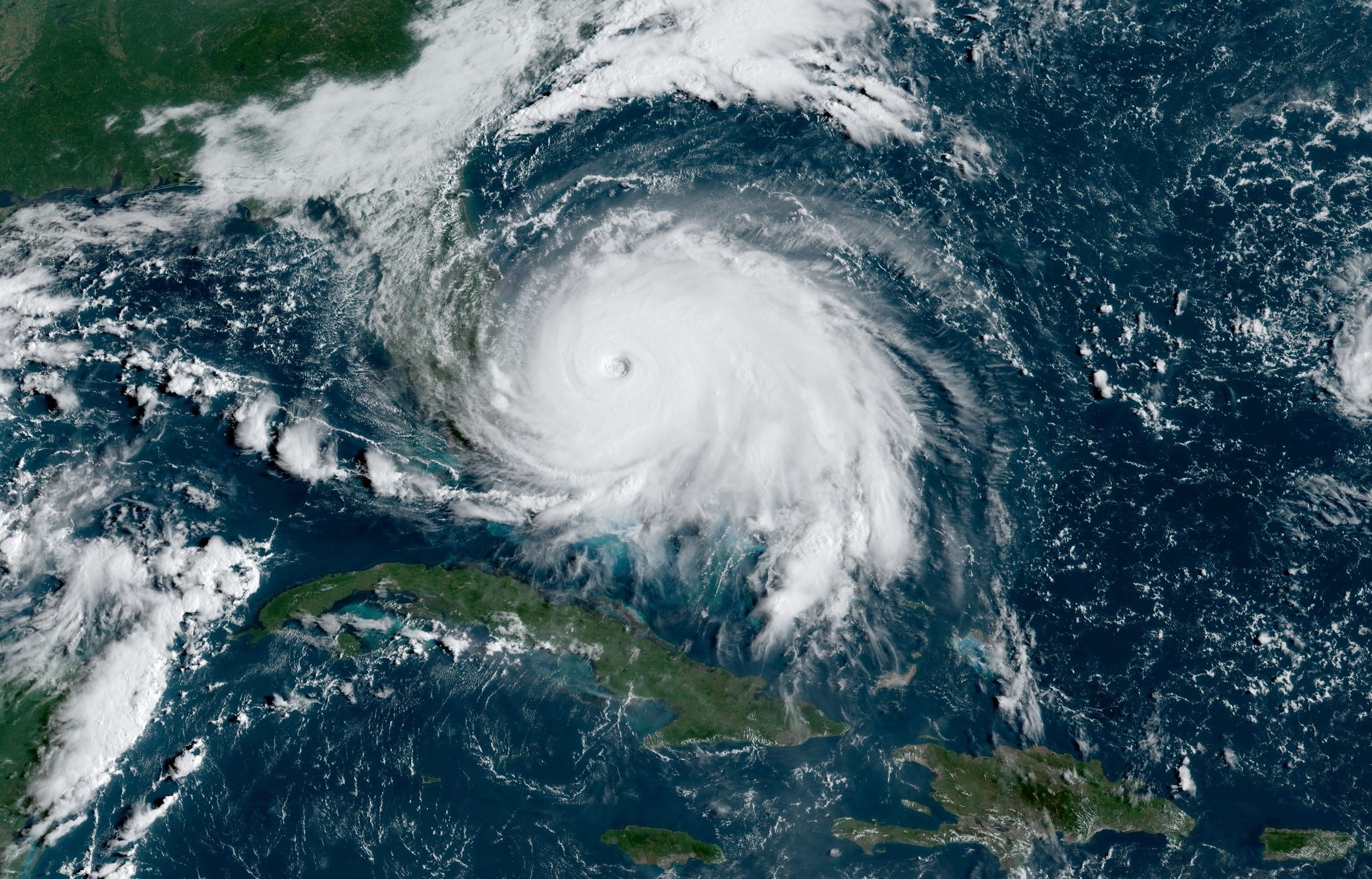
Satellite images, 03.09., 14 UTC
Image Credit: NOAA GOES Image Viewer
|
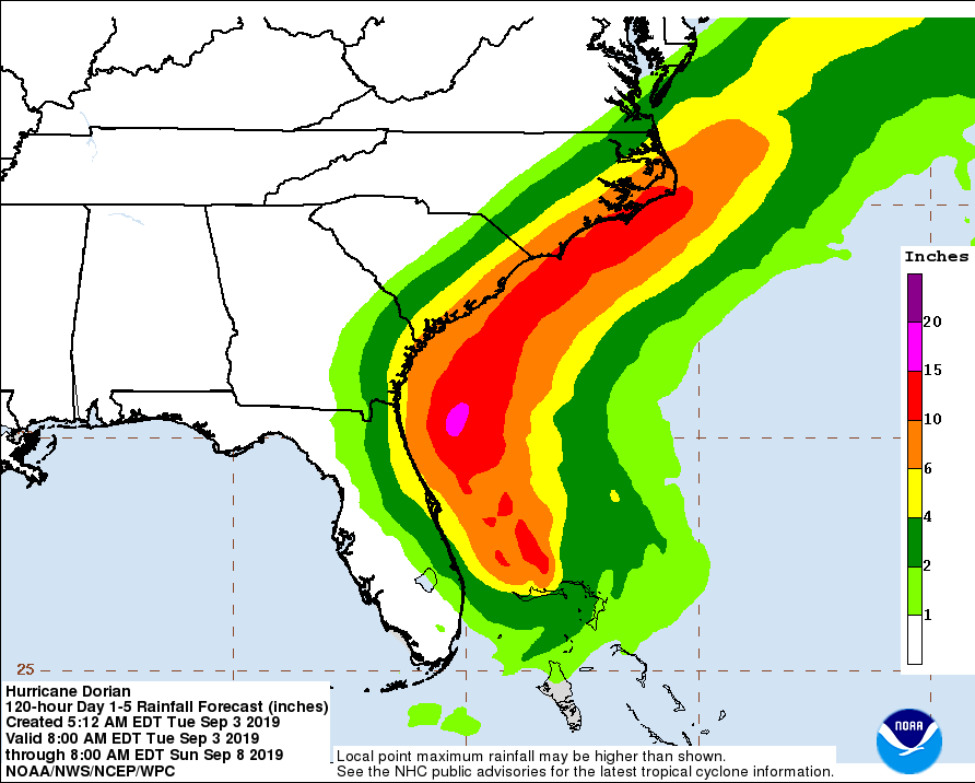
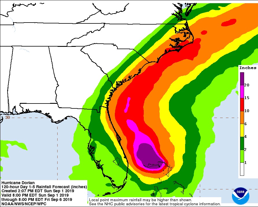
Predicted accumulated precipitation,
08.09., 12 UTC
Image Credit: NHC / NOAA
|
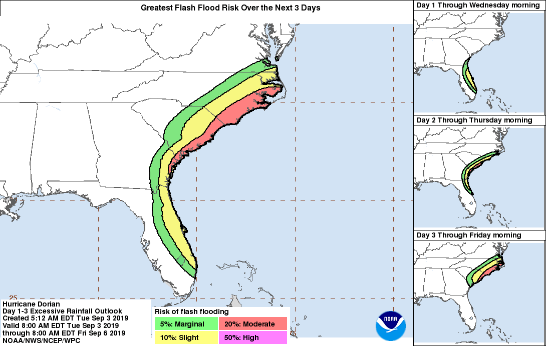
Flash flooding risk,
03.09. 12 UTC until 06.09. 12 UTC
Image Credit: NHC / NOAA
|
Hurricane DORIAN
Carribean, Eastern USA, Eastern Canada
Issued: Tuesday, 03 September 2019, 18:45 CET
After more than 12 hours of almost stationarity hurricane DORIAN finally started moving to the north-northwest in the last hours.
Due to an eye replacement cycle DORIANs intensity decreased to category 3. Still live-threatening situation.
27 Aug - 09 Sep 2019
After the eye has wobbled around over the island of Grand Bahama for more than 12 hours, DORIAN starts moving north-northwest now.
The eye is currently located about 85 km north of Freeport, Grand Bahama Island. The core pressure of the hurricane is 955 hPa.
The mean winds still reach 175 kph with gusts up to 215 kph.
While DORIAN will move parallel to the east coast of Florida and Georgia at a distance of about 140 km, it will approach
the mainland in South Carolina and touch the coast in North Carolina. Until then, the intensity of the hurricane will
hardly change. The system will weaken further when it encounters significantly colder water masses north of North Carolina.
According to the latest forecasts, DORIAN may maintain its hurricane status on its way north beyond 45 degrees latitude and
even make landfall on Newfoundland as a hurricane.
Even if the system does not make landfall in Florida, there is a danger of hurricane-like winds, especially near the extensive rainbands.
There is also a risk of rainfall of up to 200 mm and resulting flooding and landslides. On the entire east coast, especially in Carolina,
there is the danger of a storm surge of up to 2 m.
Monday, 02 September 2019, 16:45 CET

|
|
|

|
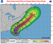
Tropical storm (≥ 8 bft) probability,
02.09., 06 UTC
Image Credit: NHC / NOAA
|
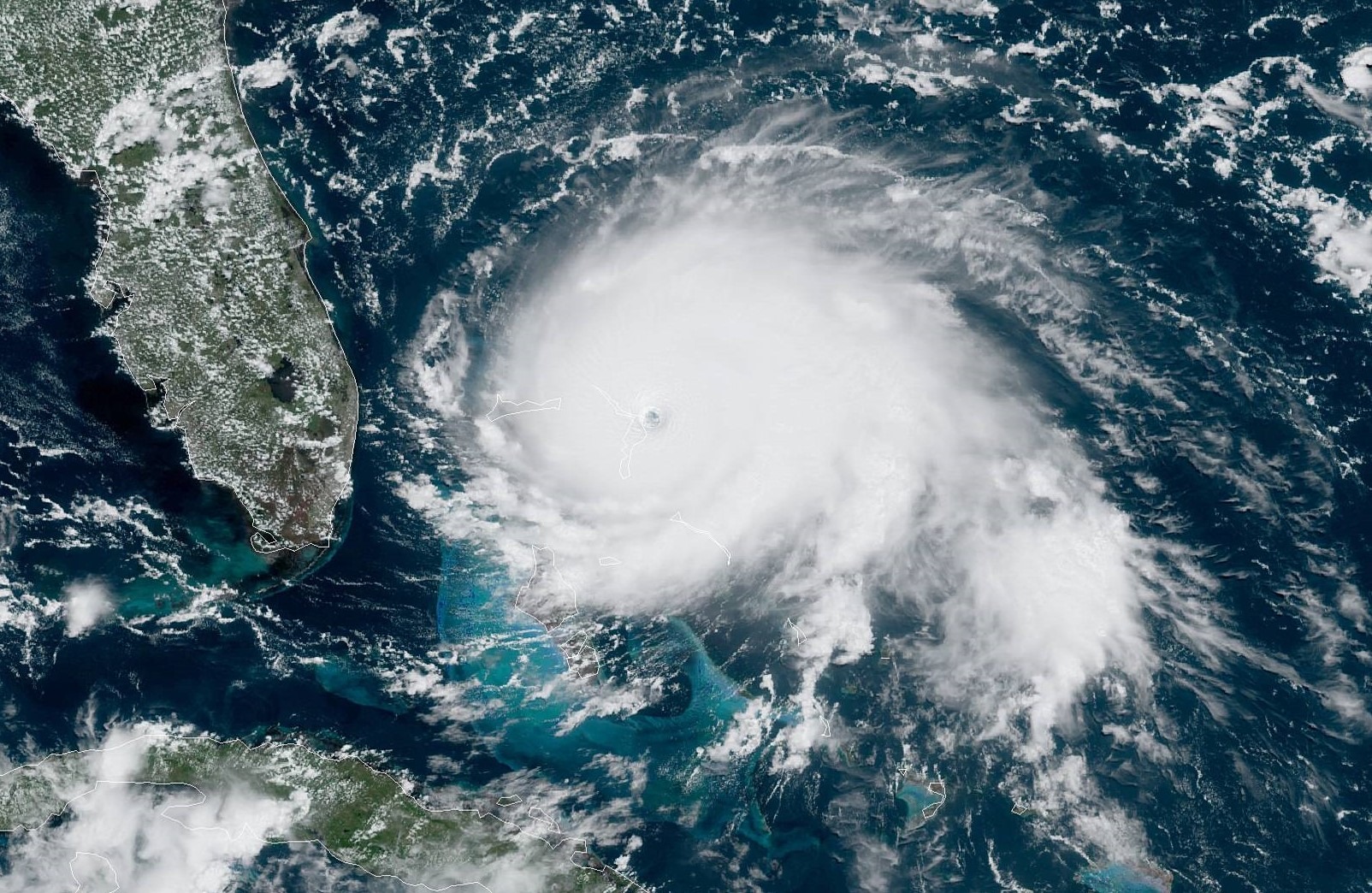
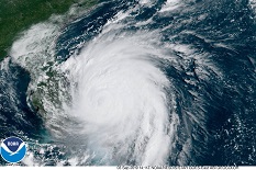
Satellite images, 02.09., 14 UTC
Image Credit: NOAA GOES Image Viewer
|
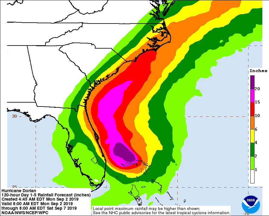
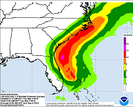
Predicted accumulated precipitation,
07.09., 12 UTC
Image Credit: NHC / NOAA
|
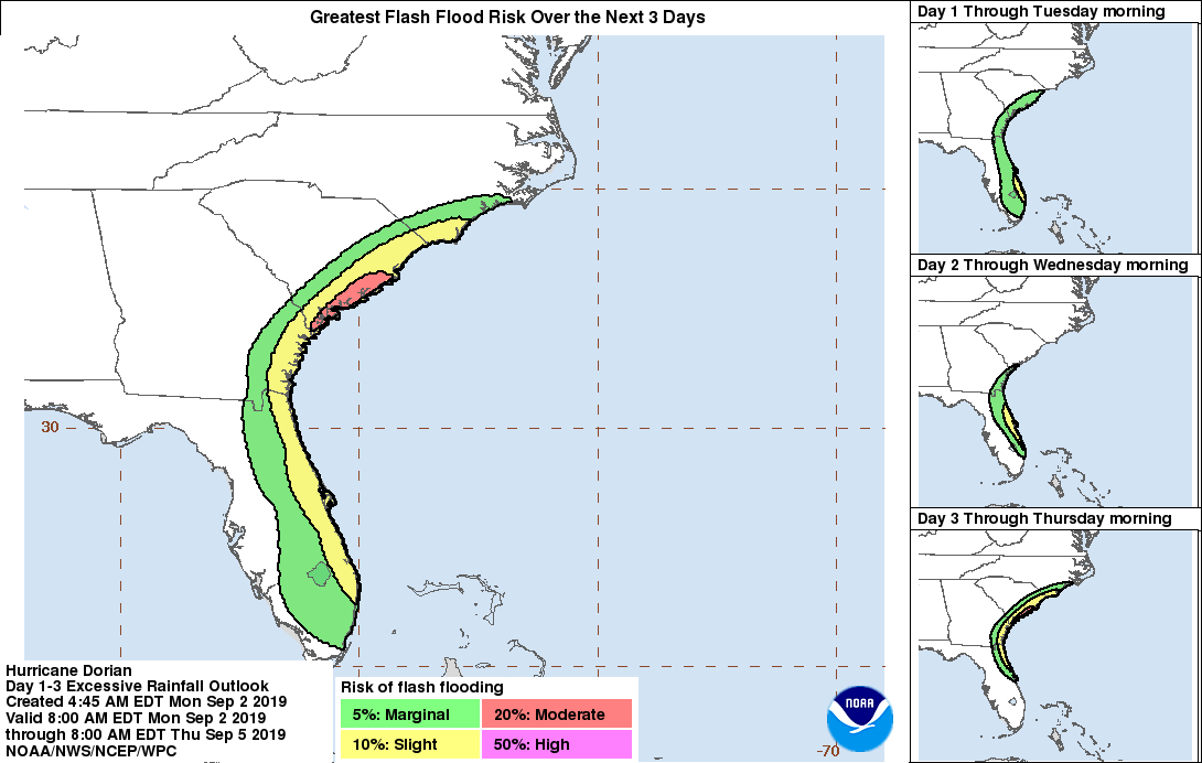
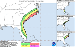
Flash flooding risk,
02.09. 12 UTC until 05.09. 12 UTC
Image Credit: NHC / NOAA
|
Hurricane DORIAN
Carribean, Eastern USA, Eastern Canada
Issued: Monday, 02 September 2019, 16:45 CET
Still category 5 Hurricane DORIAN almost becomes stationary over the Island of Grand Bahama. The storm is expected to shift northwards
within the next 24 hours. Even without a land fall on the US mainland, hurricane-like winds and precipitation of up to 300 mm must be expected.
27 Aug - 09 Sep 2019
The eye of Category 5 Hurricane DORIAN is currently located over the Island of Grand Bahama. Maximum mean winds are 270 kph with gusts
up to 325 kph. The core pressure of the hurricane is 916 hPa.
DORIAN became almost stationary with an movement of only 2 kph in western direction. This leads to enormous amounts of rain and hurricane-like
winds on the Island of Grand Bahama and Great Abaco. Within 72 hours, rainfall of up to 750 mm may fall. This is more than the average
annual value in Karlsruhe, Germany (728 mm).
Tomorrow, Tuesday evening, the system is expected to be deflected northwards from a trough over the mainland of the USA. According
to current forecasts, the hurricane will travel along the east coast of Florida, Georgia and South Carolina with a distance of
approx. 90 km. As can be seen on the satellite image, some rainbands extend up to several hundred kilometers from the center,
especially in the west southwest of the eye. Flash flooding and landslides, just as hurricane-like winds may not only occur
on the coastal areas but also in the inland of Florida.
In North Carolina the storm will come very close to the coast or even make landfall. Especially the Outer Banks and the
bordering estuaries of the Neuse River or the Pamlico River but also in the west of the Albemarle Sound there can be
enormous storm surges of up to 1.75 m due to the east winds prevailing north of the hurricane.
Sunday, 01 September 2019, 22:45 CET
|

|

|
|
DORIANs trajectory, 01.09., 12 UTC
Image Credit: NHC / NOAA
|
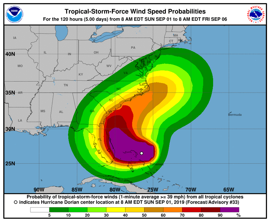
Tropical storm (≥ 8 bft) probability,
01.09., 12 UTC
Image Credit: NHC / NOAA
|
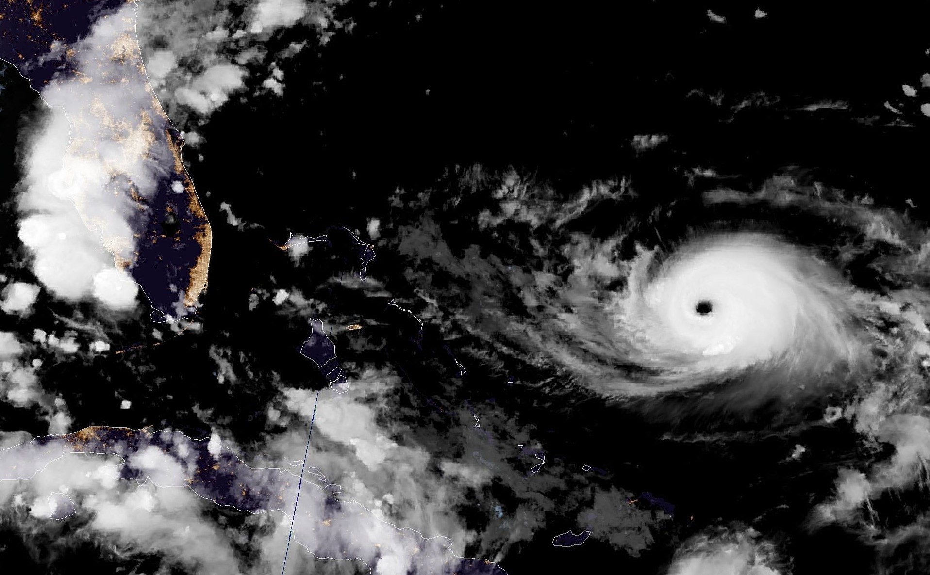
Satellite images, 01.09., 18 UTC
Image Credit: NHC / NOAA
|
Predicted accumulated precipitation,
07.09., 00 UTC
Image Credit: NHC / NOAA
|
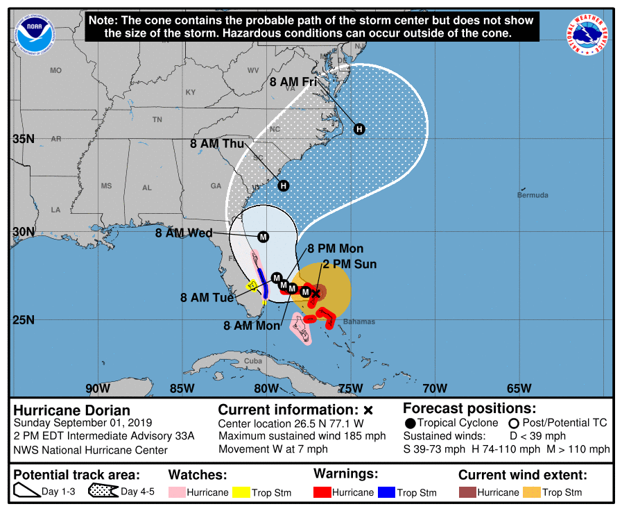
Hurricane DORIAN
Carribean, Eastern USA, Eastern Canada
Issued: Sunday, 01 September 2019, 22:45 CET
Catastrophic Hurricane DORIAN has developed into a Category 5 hurricane and made landfall on Great Abaco
Island at 18 UTC, 01 September. Maximum sustained winds were 300 kph at that time which is the strongest Atlantic hurricane landfall on record.
27 Aug - 09 Sep 2019
Due to the high sea surface temperature in the Caribbean Sea and minimal vertical wind shear in the atmosphere, DORIAN was intesified into a
catastrophic Category 5 hurricane. The maximum mean winds are 300 kph with gusts of up to 360 kph. The eye of the storm is currently over the
Caribbean island of Great Abaco. The minimum pressure in the eye is 911 hPa. The system moves with approx. 11 kph in western direction.
The eye of the storm is expected to pass over Grand Bahama on September 2, 06 UTC. According to the latest forecasts, the storm will approach
the east coast of Florida (Palm Beach) up to 130 km before being deflected to the north. From then on the trajectory will proceed parallel to
the east coast of Florida, Gerogia and South Carolina. Landfall in South or North Carolina cannot be excluded. By then, DORIAN will have
downgraded to a Category 2 or Category 1 hurricane.
Wind speeds of up to 300 kph must be expected in the northern Caribbean islands. Severe storm damage is expected. In addition,
rainfall of up to 650 mm is expected.
On the east coast of the USA, wind speeds of up to 250 kph and precipitation rates of up to 300 mm must be expected.
Saturday, 31 August 2019, 11:00 CET
|
|

|
|
DORIANs trajectory, 31.08., 02 UTC
Image Credit: NHC / NOAA
|
Tropical storm (≥ 8 bft) probability,
30.08., 20 UTC
Image Credit: NHC / NOAA
|
Satellite images, 31.08., 02 UTC
Image Credit: NHC / NOAA
|
Predicted accumulated precipitation,
06.09., 20 UTC
Image Credit: NHC / NOAA
|
Hurricane DORIAN
Carribean, Eastern USA, Eastern Canada
Issued: Saturday, 31 August 2019, 11:00 CET
DORIAN has intensified into a Category 4 hurricane and poses a significant threat to Florida and the nortwestern Bahamas.
Total precipitation values of 400 mm possible, locally even more.
27 Aug - 09 Sep 2019
Hurricane DORIAN has strengthened into a Category 4 hurricane in the last few hours and will remain in this category
until Tuesday. Yesterday evening at 20:30 DORIAN was about 925 km east of West Palm Beach/Florida.
The hurricane moves northwest at a speed of 10 kph (17 km/h). Today DORIAN passes north of the
southeastern and central Bahamas. The east coast of Florida is expected to be reached on Monday evening.
DORIAN still belongs to category 4 (gusts of wind up to 230 km/h).
In addition to the risk of severe storm damage, flooding and landslides also pose a risk. In the northern Bahamas and
the south of Florida, rainfall of up to 400 mm and precipitation intensities of up to 150 mm/3h must be expected.
Friday, 30 August 2019, 19:45 CET

|
|
|
|
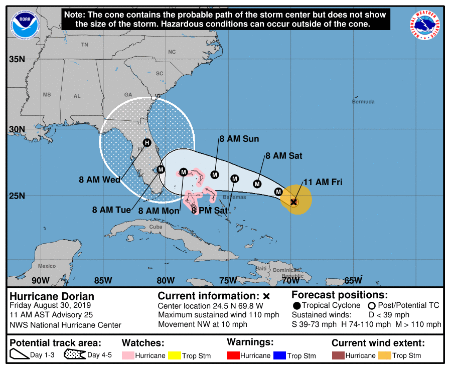
DORIANs trajectory, 30.08., 15 UTC
Image Credit: NHC / NOAA
|
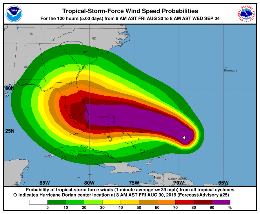
Tropical storm (≥ 8 bft) probability,
30.08., 12 UTC
Image Credit: NHC / NOAA
|
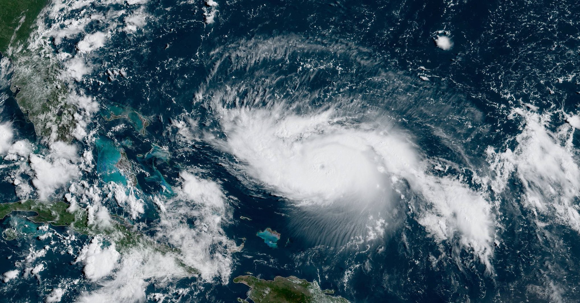
Satellite images, 30.08., 15 UTC
Image Credit: NHC / NOAA
|
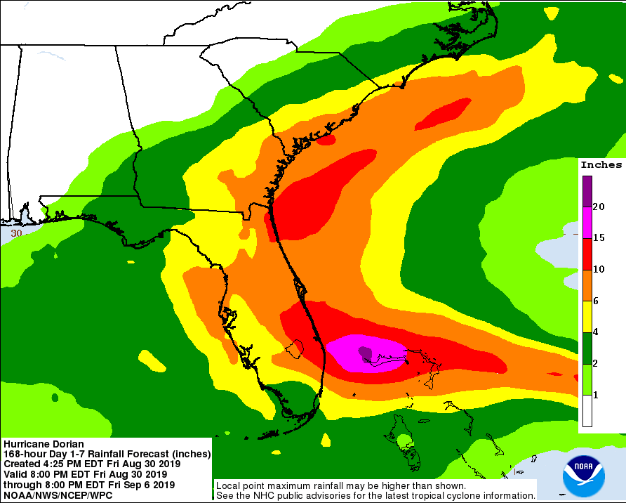
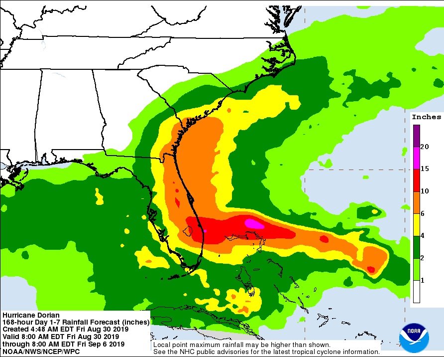
Predicted accumulated precipitation,
06.09., 12 UTC
Image Credit: NHC / NOAA
|
Hurricane DORIAN
Carribean, Eastern USA, Eastern Canada
Issued: Friday, 30 August 2019, 19:45 CET
DORIAN has intensified into a Category 2 hurricane and poses a significant threat to Florida and the nortwestern Bahamas.
Intensification up to Category 4 expected. Total precipitation values of 400 mm possible, locally even more.
27 Aug - 09 Sep 2019
Hurricane DORIAN is currently located approximately 350 km north-northwest of the Turks- and Caicos Islands. The mean
wind speeds are 175 kph, in gusts up to 205 kph. DORIAN's core pressure is currently 972 hPa. The tropical system moves
northwest with a displacement speed of about 18 kph.
According to the latest predictions, DORIAN's trajectory leads over the Abaco Islands and Grand Bahama. On September 03,
landfall as upper Category 3 or lower Category 4 Hurricane is expected in Palm Beach, Florida.
In addition to the risk of severe storm damage, flooding and landslides also pose a risk. In the northern Bahamas and
the south of Florida, rainfall of up to 400 mm and precipitation intensities of up to 150 mm/3h must be expected.
Thursday, 29 August 2019, 11:00 CET
|
|
|
|
DORIANs trajectory, 29.08., 23 UTC
Image Credit: NHC / NOAA
|
Tropical storm (≥ 8 bft) probability,
28.08., 20 UTC
Image Credit: NHC / NOAA
|
Satellite images, 28.08., 23 UTC
Image Credit: NHC / NOAA
|
Predicted accumulated precipitation,
05.09., 00 UTC
Image Credit: Wetterzentrale
|
Hurricane DORIAN
Carribean, Eastern USA, Eastern Canada
Issued: Thursday, 29 August 2019, 11:00 CET
Hurricane DORIAN moves with forward speed of 13 kph towards ther northwest. Mean winds of 80 kph,
in gusts up to 130 kph are expected. Total precipitation of 200 mm possible in eastern Puerto Rico.
27 Aug - 09 Sep 2019
Hurricane DORIAN has been located about 95 km northwest of San Juan, Puerto Rico since yesterday evening at 8 pm.
It moves with a forward speed of 13 kph (20 km/h) towards the northwest. The northwestern direction is expected
to remain until Friday. DORIAN is crossing the Atlantic far east of the southeastern and central Bahamas.
The maximum average speed is 80 kph (130 km/h), much higher in gusts. Gusts of wind can occur up to a distance of 30
km from the centre. In the next few days, the hurricane will pick up speed again, so that it will develop into a
stronger hurricane.
Due to heavy precipitation, storm surges may continue to occur in the central and northwestern
Bahamas as well as on the east coast of Florida during the week and at weekends. Where exactly
storm surges occur remains to be seen.
In Puerto Rico, wind speeds of 100 kph, gusts of up to 130 kph and rainfall of up to 200 mm/24h must be calculated.
There is a risk of storm damage, flooding and landslides.
Wednesday, 28 August 2019, 18:00 CET
|
|
|
|
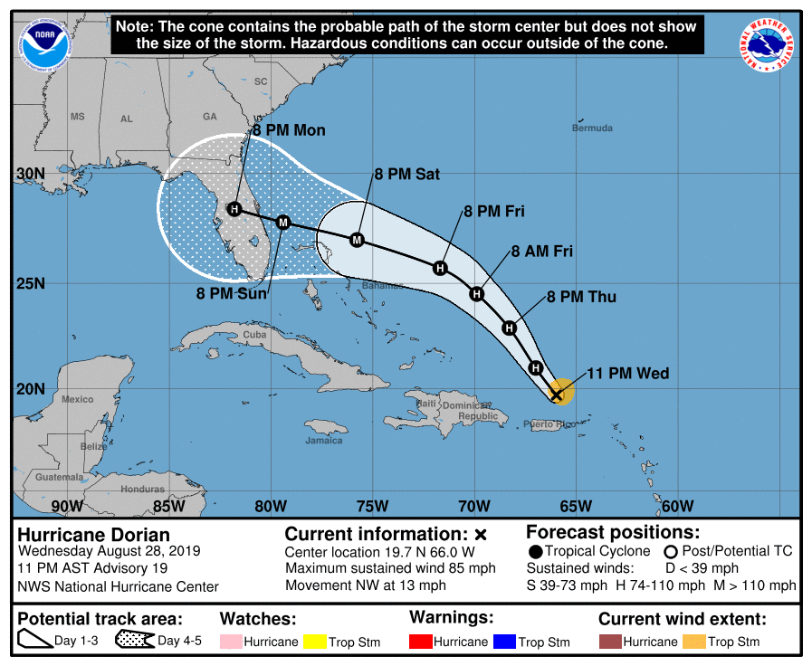
DORIANs trajectory, 28.08., 15 UTC
Image Credit: NHC / NOAA
|
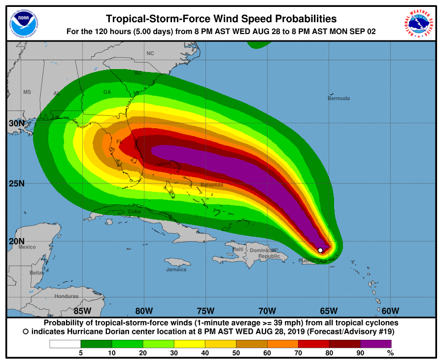
Tropical storm (≥ 8 bft) probability,
28.08., 15 UTC
Image Credit: NHC / NOAA
|
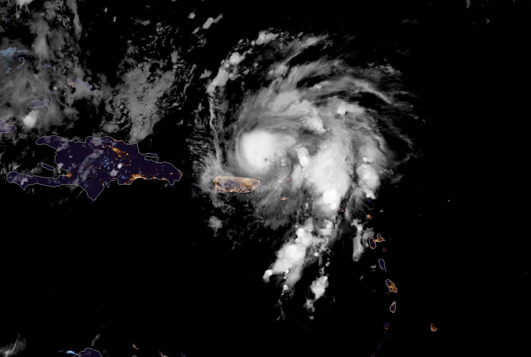
Satellite images (visible), 28.08., 12 UTC
Image Credit: NHC / NOAA
|
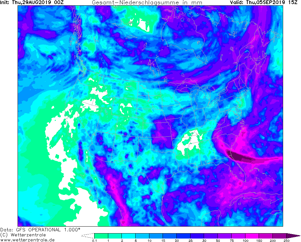
Predicted accumulated precipitation,
05.09., 00 UTC
Image Credit: Wetterzentrale
|
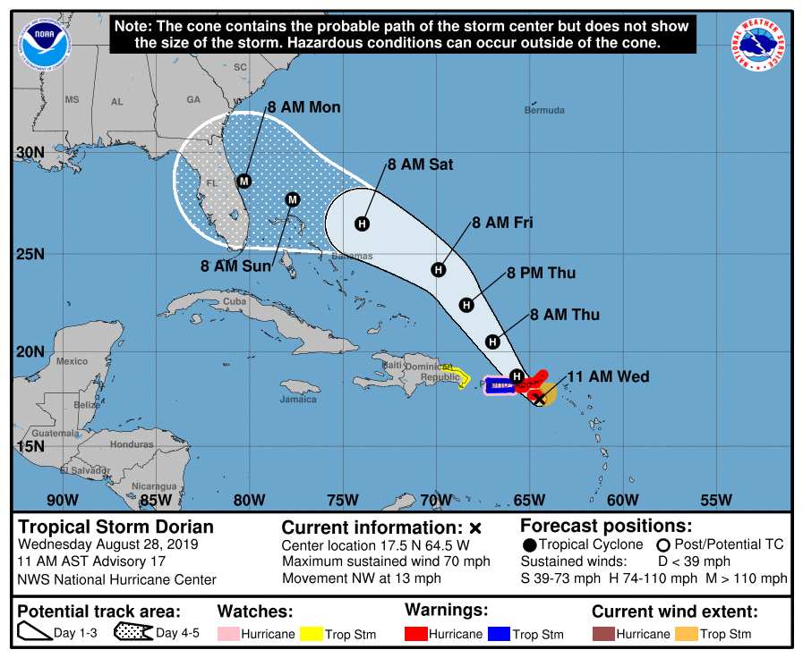
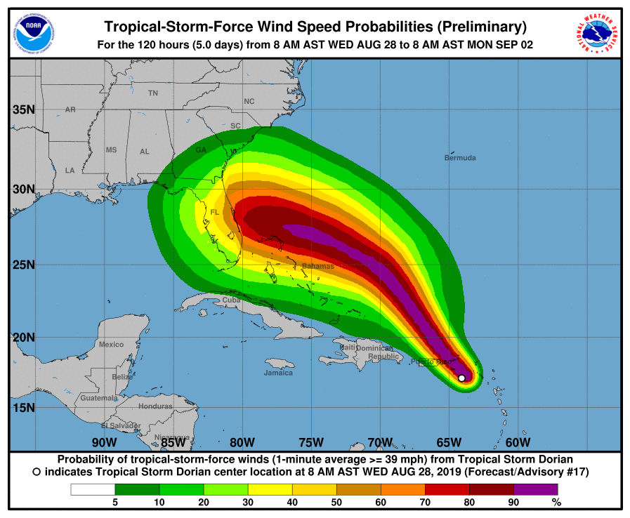
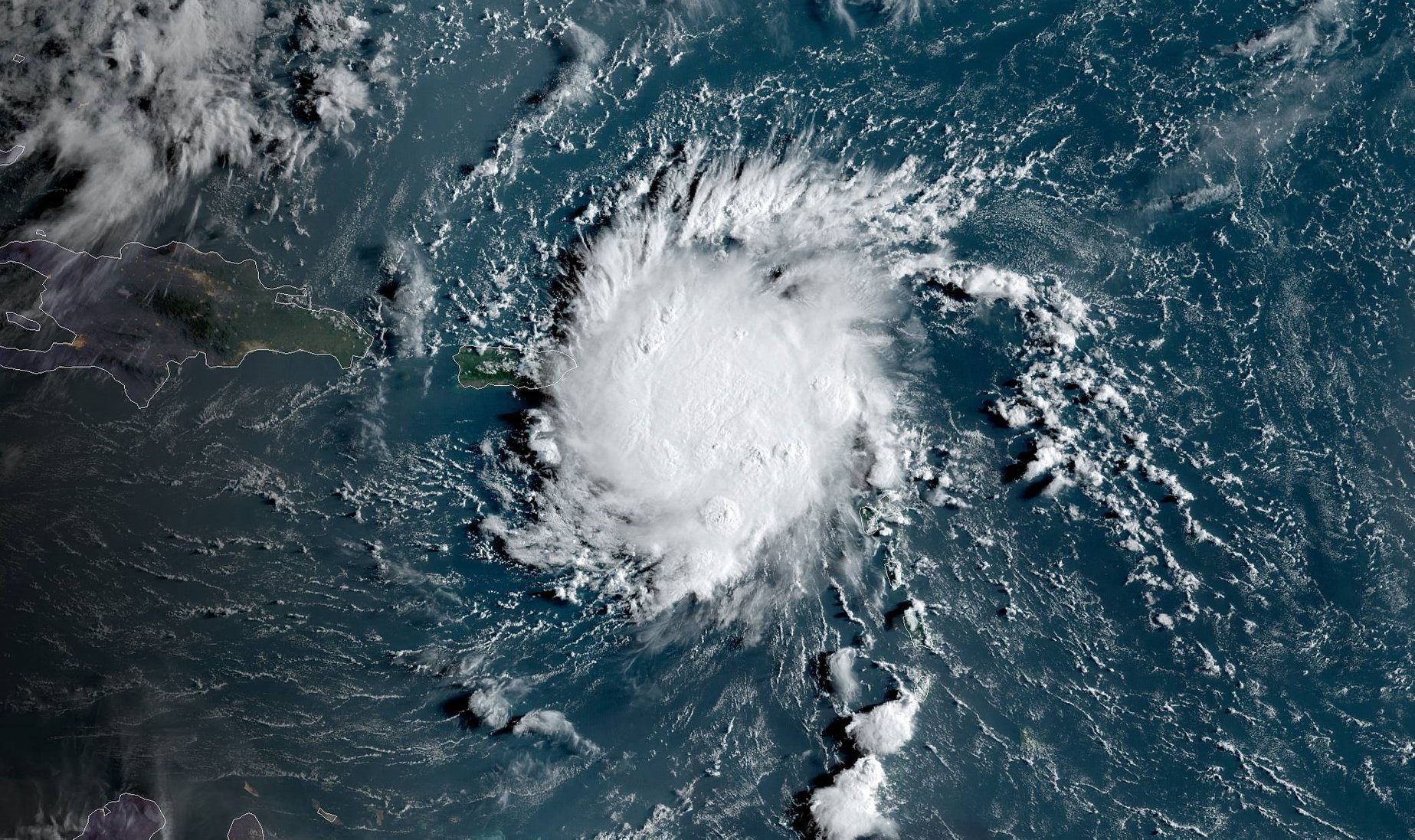
Tropical Storm DORIAN
Carribean, Eastern USA, Eastern Canada
Issued: Wednesday, 28 August 2019, 18:00 CET
Tropical storm DORIAN is likely so reach hurricane-strength within the next 6 hours. Mean winds of 100 kph
in Puerto Rico, in gusts up to 130 kph. Total precipitation of 200 mm possible in eastern Puerto Rico.
27 Aug - 09 Sep 2019
Tropical storm DORIAN is currently located 100 km south of Isla de Vieques and is moving northwest with a
displacement speed of 20 kph. Its trajectory spans over the island state of Puerto Rico and then continues
in a northwesterly direction towards the east coast of the American mainland.
It is likely that the system will reach hurricane strength within the next few hours. On 29 August at 00 UTC,
mean winds of 120 kph and gusts of up to 150 kph are expected. The storm will continue to intensify due to
the high sea surface temperature in the Caribbean. On 01 September wind speeds of up to 185 kph and gusts
of up to 225 kph are expected, equivalent to hurricane category 3.
In Puerto Rico, wind speeds of 100 kph, gusts of up to 130 kph and rainfall of up to 200 mm/24h must be calculated.
There is a risk of storm damage, flooding and landslides.
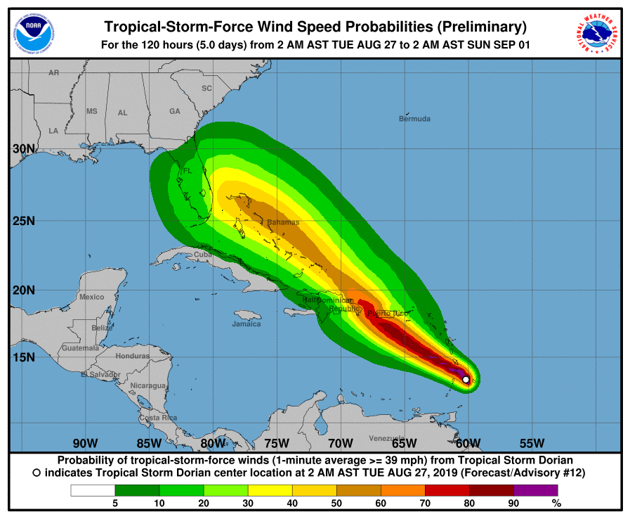
Tuesday, 27 August 2019, 12:15 CET
|
|
|
|
DORIANs trajectory, 27.08., 06 UTC
Image Credit: NHC / NOAA
|
Tropical storm (≥ 8 bft) probability,
27.08., 12 UTC
Image Credit: NHC / NOAA
|
Predicted mean wind Puerto Rico,
28.08., 21 UTC
Image Credit: NWS
|
Satellite images (visible), 26.08., 18 UTC
Image Credit: NHC / NOAA
|
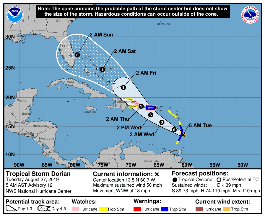
Tropical Storm DORIAN
Carribean, Eastern USA, Eastern Canada
Issued: Tuesday, 27 August 2019, 12:15 CET
Tropical storm DORIAN is the third tropical system of the 2019 Atlantic Hurricane Season. Tropical storm conditions are to be expected
in the Lesser Antilles on Tuesday and in Puerto Rico on Wednesday. Rainfall up to 150mm possible.
27 Aug - 09 Sep 2019
Tropical storm DORIAN developed on August 24 in an area of strong convection and is currently located above the island of St. Lucia.
It moves with a displacement speed of 20 kph in a west-northwest direction.
The current wind speeds are 85 kph, the core pressure approx. 1005 hPa. Tomorrow , Wednesday, from 12 UTC on the storm will move
about 120 km south of Puerto Rico. Wind speeds of 110 kph and gusts of up to 140 kph are expected on the southwest coast.
In the Lesser Antilles and in Puerto Rico up to 1500 mm precipitation are expected. Orographic precipitation can also lead
to higher amounts locally. There is a risk of flooding and landslides.
Issued: August 27, 2019, 12:15 CET
FS
Issued: August 28, 2019, 18:00 CET
FS
Issued: August 29, 2019, 11:00 CET
CL
Issued: August 30, 2019, 19:45 CET
FS
Issued: August 31, 2019, 11:00 CET
CL
Issued: September 01, 2019, 22:45 CET
FS
Issued: September 02, 2019, 16:45 CET
FS
Issued: September 03, 2019, 18:45 CET
FS
Issued: September 05, 2019, 16:00 CET
FS
Issued: September 06, 2019, 15:00 CET
FS
|